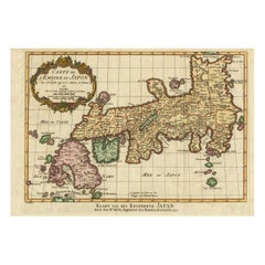
Items Similar to Rare Antique Map of Japan with Place Names Given in Dutch Nomenclature, 1726
Want more images or videos?
Request additional images or videos from the seller
1 of 6
Rare Antique Map of Japan with Place Names Given in Dutch Nomenclature, 1726
$2,156.66
$2,695.8220% Off
£1,605.49
£2,006.8720% Off
€1,800
€2,25020% Off
CA$2,954.08
CA$3,692.6020% Off
A$3,285.59
A$4,106.9820% Off
CHF 1,715.63
CHF 2,144.5420% Off
MX$39,982.08
MX$49,977.5920% Off
NOK 21,911.22
NOK 27,389.0220% Off
SEK 20,548.86
SEK 25,686.0720% Off
DKK 13,702.77
DKK 17,128.4620% Off
Shipping
Retrieving quote...The 1stDibs Promise:
Authenticity Guarantee,
Money-Back Guarantee,
24-Hour Cancellation
About the Item
Antique map titled 'Nieuwe Kaart van het Eyland Japan'.
Rare map of Japan, it shows each of the Japanese provinces, with place names along the route from Nagasaki to Edo. The place names are all given in Dutch nomenclature. This map originates from 'Oud en Nieuw Oost-Indiën' by F. Valentijn. Artists and Engravers: François Valentijn (1666-1727), a missionary, worked at Amboina from 1684 to 1694 and 1705 to 1713 and travelled extensively in the VOC's lands.
Artist: François Valentijn (1666-1727), a missionary, worked at Amboina from 1684 to 1694 and 1705 to 1713 and travelled extensively in the VOC's lands.
Condition: Very good, please study image carefully.
Date: 1726
Overall size: 59 x 50 cm.
Image size: 56 x 44 cm.
We sell original antique maps to collectors, historians, educators and interior decorators all over the world. Our collection includes a wide range of authentic antique maps from the 16th to the 20th centuries. Buying and collecting antique maps is a tradition that goes back hundreds of years. Antique maps have proved a richly rewarding investment over the past decade, thanks to a growing appreciation of their unique historical appeal. Today the decorative qualities of antique maps are widely recognized by interior designers who appreciate their beauty and design flexibility. Depending on the individual map, presentation, and context, a rare or antique map can be modern, traditional, abstract, figurative, serious or whimsical. We offer a wide range of authentic antique maps for any budget.
- Dimensions:Height: 23.23 in (59 cm)Width: 19.69 in (50 cm)Depth: 0 in (0.01 mm)
- Materials and Techniques:
- Period:
- Date of Manufacture:1726
- Condition:Condition: Very good, please study image carefully.
- Seller Location:Langweer, NL
- Reference Number:Seller: BGRN-2511stDibs: LU3054326361432
About the Seller
5.0
Recognized Seller
These prestigious sellers are industry leaders and represent the highest echelon for item quality and design.
Platinum Seller
Premium sellers with a 4.7+ rating and 24-hour response times
Established in 2009
1stDibs seller since 2017
2,508 sales on 1stDibs
Typical response time: <1 hour
- ShippingRetrieving quote...Shipping from: Langweer, Netherlands
- Return Policy
Authenticity Guarantee
In the unlikely event there’s an issue with an item’s authenticity, contact us within 1 year for a full refund. DetailsMoney-Back Guarantee
If your item is not as described, is damaged in transit, or does not arrive, contact us within 7 days for a full refund. Details24-Hour Cancellation
You have a 24-hour grace period in which to reconsider your purchase, with no questions asked.Vetted Professional Sellers
Our world-class sellers must adhere to strict standards for service and quality, maintaining the integrity of our listings.Price-Match Guarantee
If you find that a seller listed the same item for a lower price elsewhere, we’ll match it.Trusted Global Delivery
Our best-in-class carrier network provides specialized shipping options worldwide, including custom delivery.More From This Seller
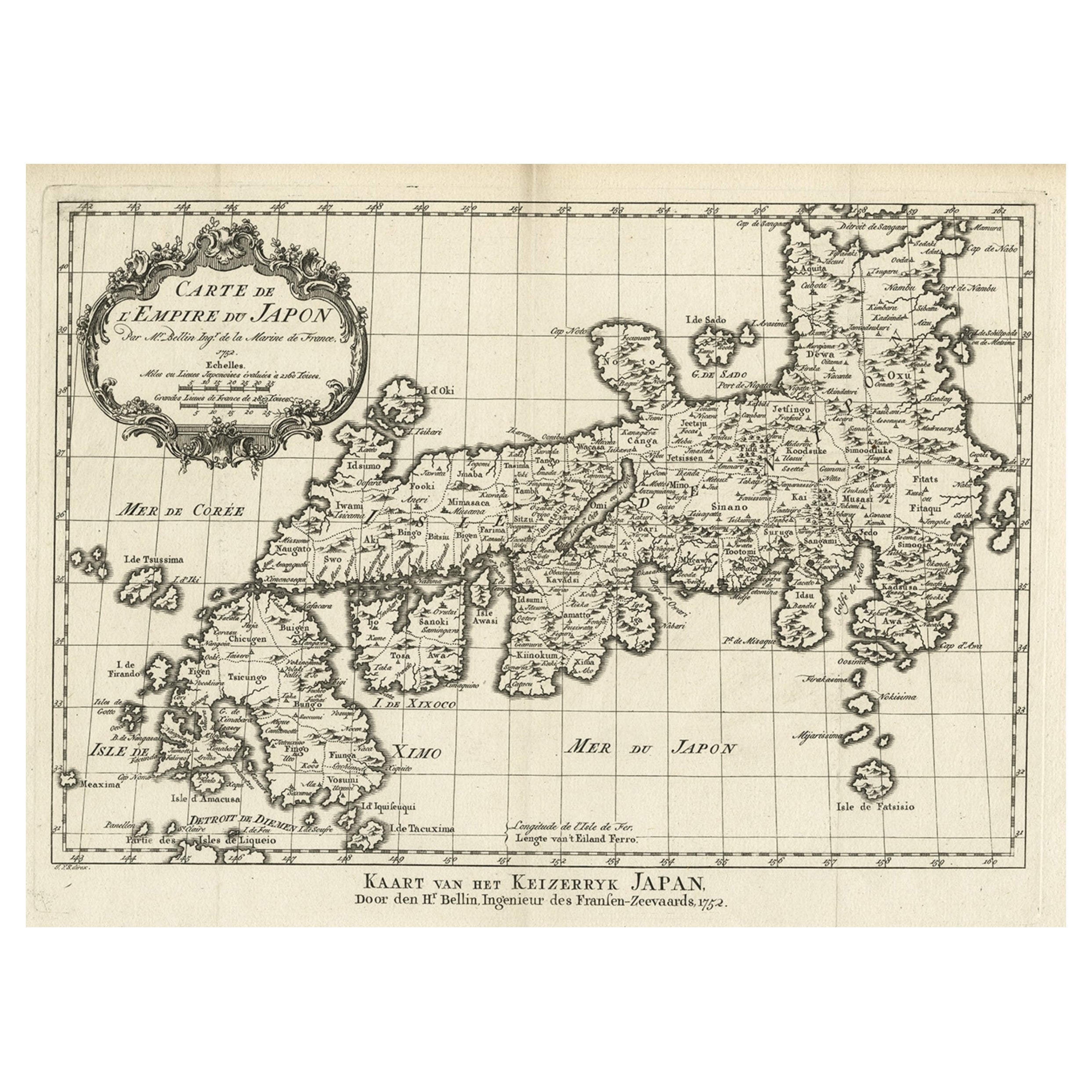
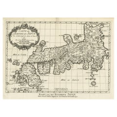
View AllAntique Map of Japan by J.N. Bellin, 1752
Located in Langweer, NL
Bellin's wonderfully detailed map of Japan from the atlas of Prevost d'Exiles' influential collection of travel narratives, Histoire Generale des Voyages. Considered the best general...
Category
Antique Mid-18th Century Maps
Materials
Paper

$440 Sale Price
20% Off
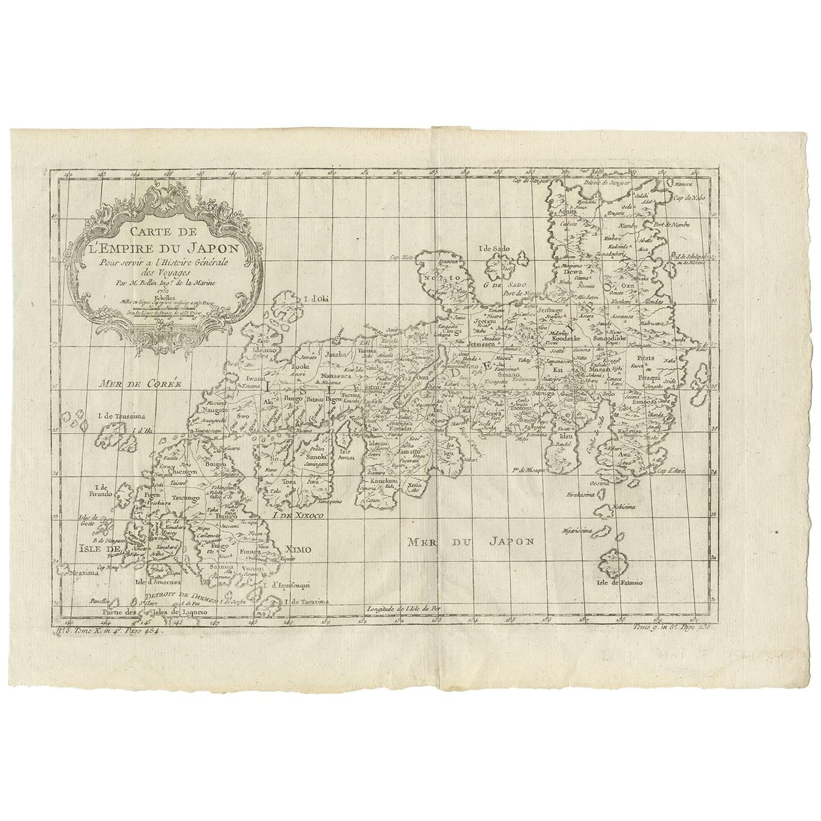
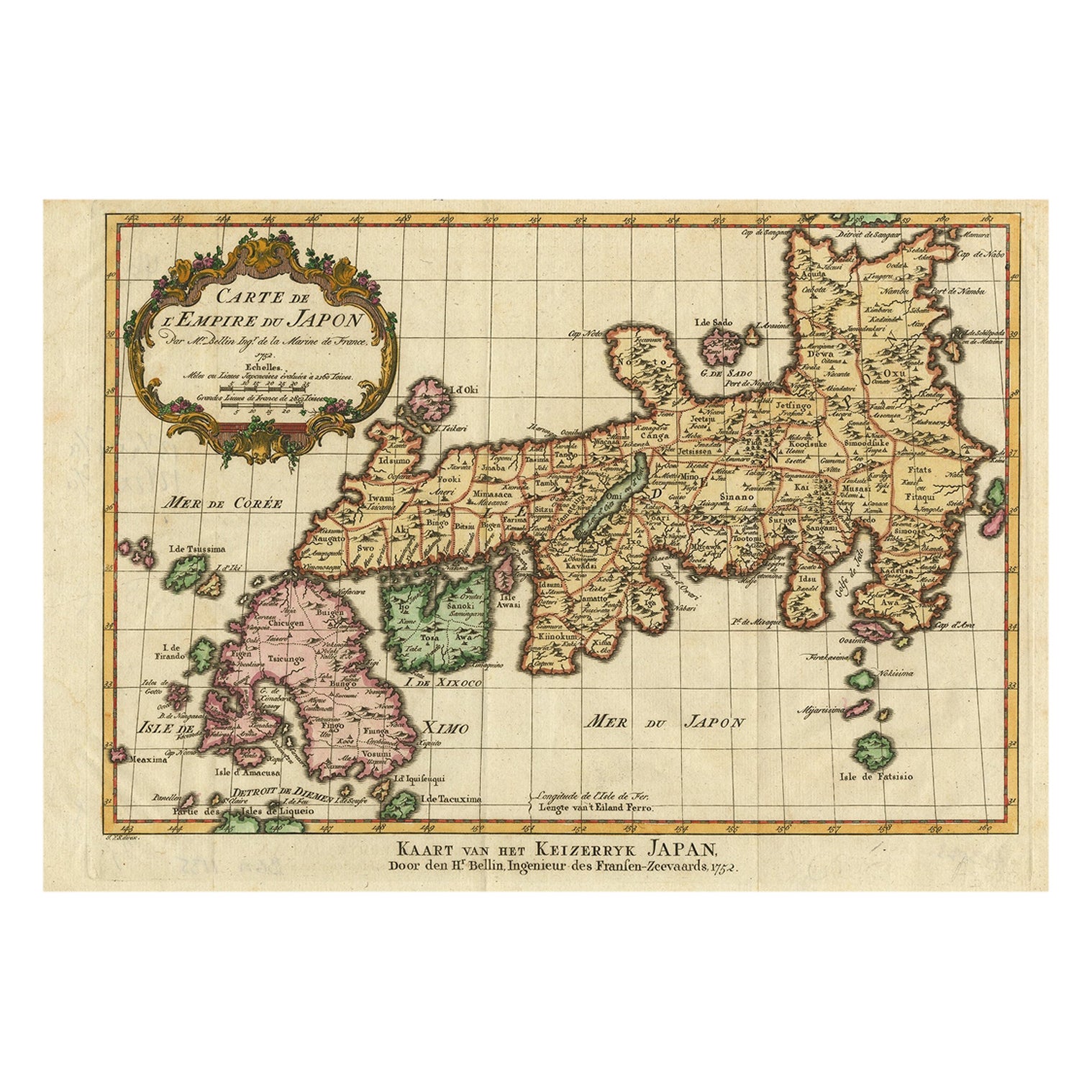
Original Antique Map of the Empire of Japan, Centered on the Bay of Osaka, c1752
Located in Langweer, NL
Antique map titled 'Carte de L'Empire de Japon (..).'
Map of the Empire of Japan. Centered on the Bay of Osaka, this map covers from Hirado (here identified as I. Firando) and Na...
Category
Antique 1750s Maps
Materials
Paper
$805 Sale Price
20% Off
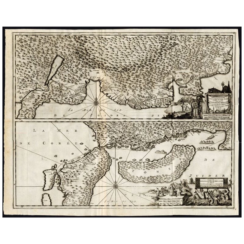
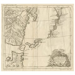
Antique Map of the Region of Osaka and Hirado Island in Japan, 1725
By Pieter Van Der Aa
Located in Langweer, NL
Antique map titled 'Description exacte et fidele des villes, bourgs et villages qui les Ambassadeurs de Hollande ont rencontrez dans leur voyage par terre de la ville Osacca jusqu'a ...
Category
Antique 18th Century Maps
Materials
Paper
$1,270 Sale Price
20% Off
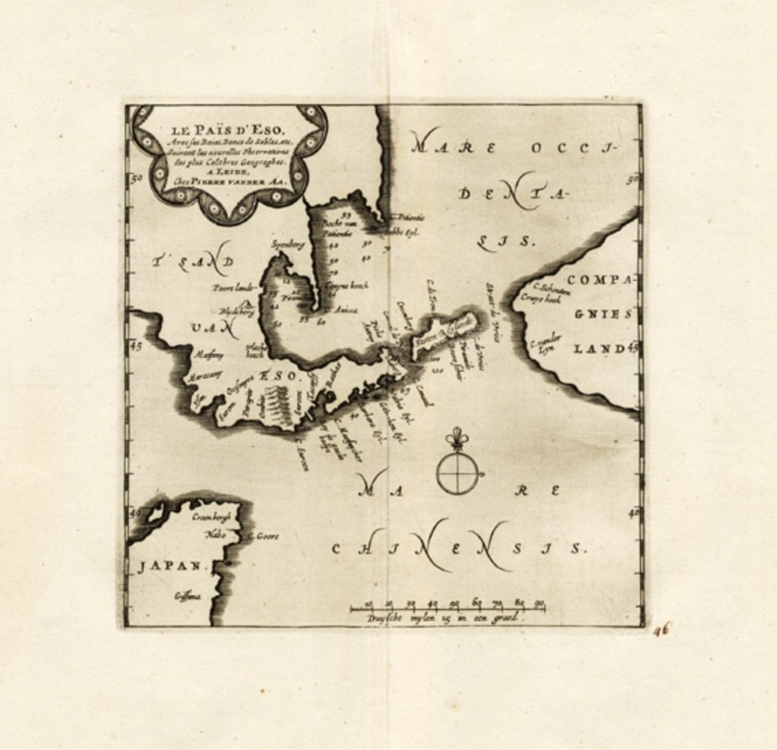
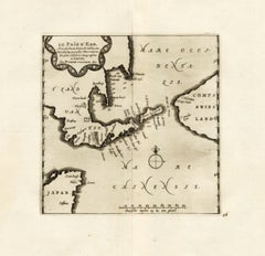
Extremely Rare Map of The land of Eso or Hokkaido in Japan, 1725
Located in Langweer, NL
Plate 46: 'Le Pais d' Eso.' (The land of Eso / Hokkaido in Japan.) Extremely rare in this edition.
This plate originates from the very scarse: 'La Galerie Agreable du Monde (..). T...
Category
Antique 18th Century Maps
Materials
Paper
$694 Sale Price
20% Off
Nice Antique Map of the Empire of Japan. Centered on the Bay of Osaka, ca.1752
Located in Langweer, NL
Antique map titled 'Carte de L'Empire de Japon (..).'
Map of the Empire of Japan. Centered on the Bay of Osaka, this map covers from Hirado (here identified as I. Firando) and Naga...
Category
Antique 1750s Maps
Materials
Paper
$910 Sale Price
20% Off
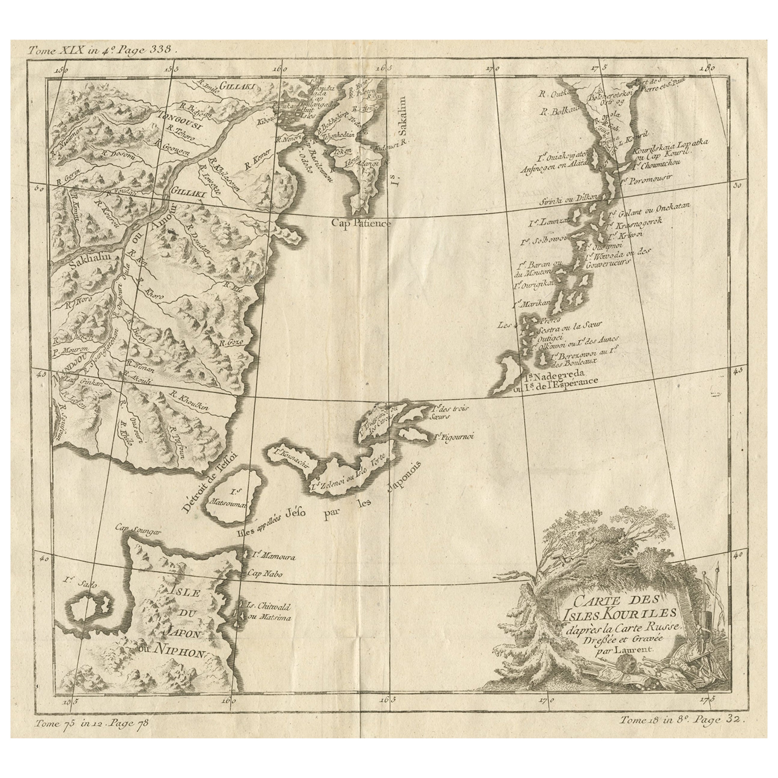
Old Map of The Kurile Islands, from Hokkaido, Japan to Kamchatka, Russia, c.1750
Located in Langweer, NL
Antique map titled 'Carte des Iles Kouriles'. Original antique map of the Kuril Islands.
The Kuril Islands or Kurile Islands are a volcanic archipelago that stretches approximate...
Category
Antique 1750s Maps
Materials
Paper
$316 Sale Price
20% Off
Free Shipping
You May Also Like
1627 Hendrik Hondius Map Entitled "Vltoniae Orientalis Pars, " Ric.a009
Located in Norton, MA
1627 Hendrik Hondius map entitled
"Vltoniae orientalis pars,"
Ric.a009
Title:
Vltoniae orientalis : pars
Title (alt.) :
Ultoniae orientalis pars
Creator:
Mercator, Gerh...
Category
Antique 17th Century Dutch Maps
Materials
Paper

Antique French Map of Asia Including China Indoneseia India, 1783
Located in Amsterdam, Noord Holland
Very nice map of Asia. 1783 Dedie au Roy.
Additional information:
Country of Manufacturing: Europe
Period: 18th century Qing (1661 - 1912)
Condition: Overall Condition B (Good Used)...
Category
Antique 18th Century European Maps
Materials
Paper

$648 Sale Price
20% Off
Original Antique Map of Switzerland, Engraved By Barlow, Dated 1807
Located in St Annes, Lancashire
Great map of Switzerland
Copper-plate engraving by Barlow
Published by Brightly & Kinnersly, Bungay, Suffolk.
Dated 1807
Unframed.
Category
Antique Early 1800s English Maps
Materials
Paper

1646 Jansson Map Entitled "Procinvia Connactiae, " Ric.a006
Located in Norton, MA
1646 Jansson map entitled
"Procinvia connactiae,"
Ric.a006
Description: The PROVINCE of CONNAVGT 490 x 380From vol 4 of Jansson's Atlas Novus 1646, published in Amsterdam with...
Category
Antique 17th Century Unknown Maps
Materials
Paper

Antique 1803 Italian Map of Asia Including China Indoneseia India
Located in Amsterdam, Noord Holland
Antique 1803 Italian Map of Asia Including China Indoneseia India
Very nice map of Asia. 1803.
Additional information:
Type: Map
Country of Manufacturing: Europe
Period: 19th centu...
Category
Antique 19th Century European Maps
Materials
Paper

$584 Sale Price
20% Off
1636 Jansson Map of Ireland Entitled "Comitatus Lageniae, " Ric.a007
Located in Norton, MA
1646 Jansson map entitled
"Procinvia connactiae,"
Ric.a006
Description: The PROVINCE of CONNAVGT 490 x 380From vol 4 of Jansson's Atlas Novus 1646, published in Amsterdam with...
Category
Antique 17th Century Unknown Maps
Materials
Paper

More Ways To Browse
Japan Antiques Collectables
Caribbean Colonial Furniture
Antique Maps West Indies
California Island Map
Pirate Antique
Map Of Holy Land
Antique Blackwood Furniture
Antique Macedonia
Antique Maps Of New York City
Victorian Compass
Antique Maps Caribbean Islands
Hungary Map
Cartographer Tool
Goa Furniture
George Fleet
Sri Lanka Map
Philippines Map
Antique Map Ceylon