Items Similar to Rare Map of the Philippines; Joseph Freewills Island & Mindanao South End, 1773


Want more images or videos?
Request additional images or videos from the seller
1 of 5
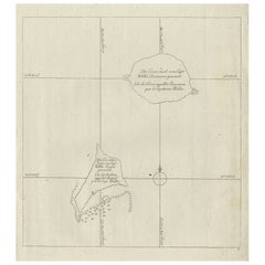
Rare Map of the Philippines; Joseph Freewills Island & Mindanao South End, 1773
$229.97
$287.4620% Off
£170.42
£213.0220% Off
€192
€24020% Off
CA$313.95
CA$392.4320% Off
A$349.25
A$436.5720% Off
CHF 183.08
CHF 228.8520% Off
MX$4,267.79
MX$5,334.7420% Off
NOK 2,331.33
NOK 2,914.1720% Off
SEK 2,194.63
SEK 2,743.2920% Off
DKK 1,461.87
DKK 1,827.3420% Off
Shipping
Retrieving quote...The 1stDibs Promise:
Authenticity Guarantee,
Money-Back Guarantee,
24-Hour Cancellation
About the Item
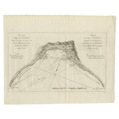
Three charts on one sheet titled '1) A Dangerous Shoal 2) Joseph Freewills Island 3) The South End of Mindanao'.
It shows Captain Carteret's voyage: Saint George's Channel to Mindanao. This print originates from 'An account of the voyages undertaken by the order of His present Majesty for making discoveries in the Southern Hemisphere, and successively performed by Commodore Byron, Captain Wallis, Captain Carteret, and Captain Cook, in the Dolphin, the Swallow, and the Endeavor (..)'.
Artists and Engravers: Published by John Hawkesworth.
Condition: Good, minor wear. Please study image carefully.
- Dimensions:Height: 11.03 in (28 cm)Width: 9.06 in (23 cm)Depth: 0 in (0.02 mm)
- Materials and Techniques:
- Period:1770-1779
- Date of Manufacture:1773
- Condition:Wear consistent with age and use.
- Seller Location:Langweer, NL
- Reference Number:Seller: JAK-382 1stDibs: LU3054326675432
About the Seller
5.0
Recognized Seller
These prestigious sellers are industry leaders and represent the highest echelon for item quality and design.
Platinum Seller
Premium sellers with a 4.7+ rating and 24-hour response times
Established in 2009
1stDibs seller since 2017
2,494 sales on 1stDibs
Typical response time: 1 hour
- ShippingRetrieving quote...Shipping from: Langweer, Netherlands
- Return Policy
Authenticity Guarantee
In the unlikely event there’s an issue with an item’s authenticity, contact us within 1 year for a full refund. DetailsMoney-Back Guarantee
If your item is not as described, is damaged in transit, or does not arrive, contact us within 7 days for a full refund. Details24-Hour Cancellation
You have a 24-hour grace period in which to reconsider your purchase, with no questions asked.Vetted Professional Sellers
Our world-class sellers must adhere to strict standards for service and quality, maintaining the integrity of our listings.Price-Match Guarantee
If you find that a seller listed the same item for a lower price elsewhere, we’ll match it.Trusted Global Delivery
Our best-in-class carrier network provides specialized shipping options worldwide, including custom delivery.More From This Seller
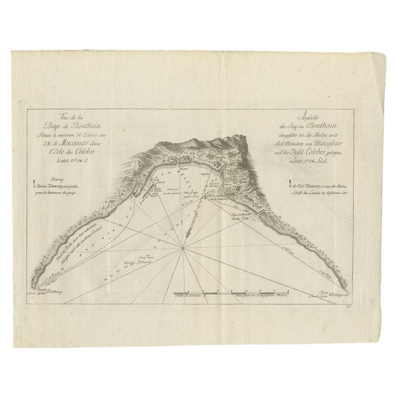
View AllAntique Map of a Bay Nearby Makassar, Celebes 'Sulawesi)' by Hawkesworth, 1774
Located in Langweer, NL
Antique map titled 'Vue de la Baye de Bonthain (..)'. Map of the island Sulawesi (Celebes), Indonesia that Philip Carteret rested his crew and made repairs to his ship the Swallow fo...
Category
Antique 18th Century Maps
Materials
Paper
$110 Sale Price
20% Off
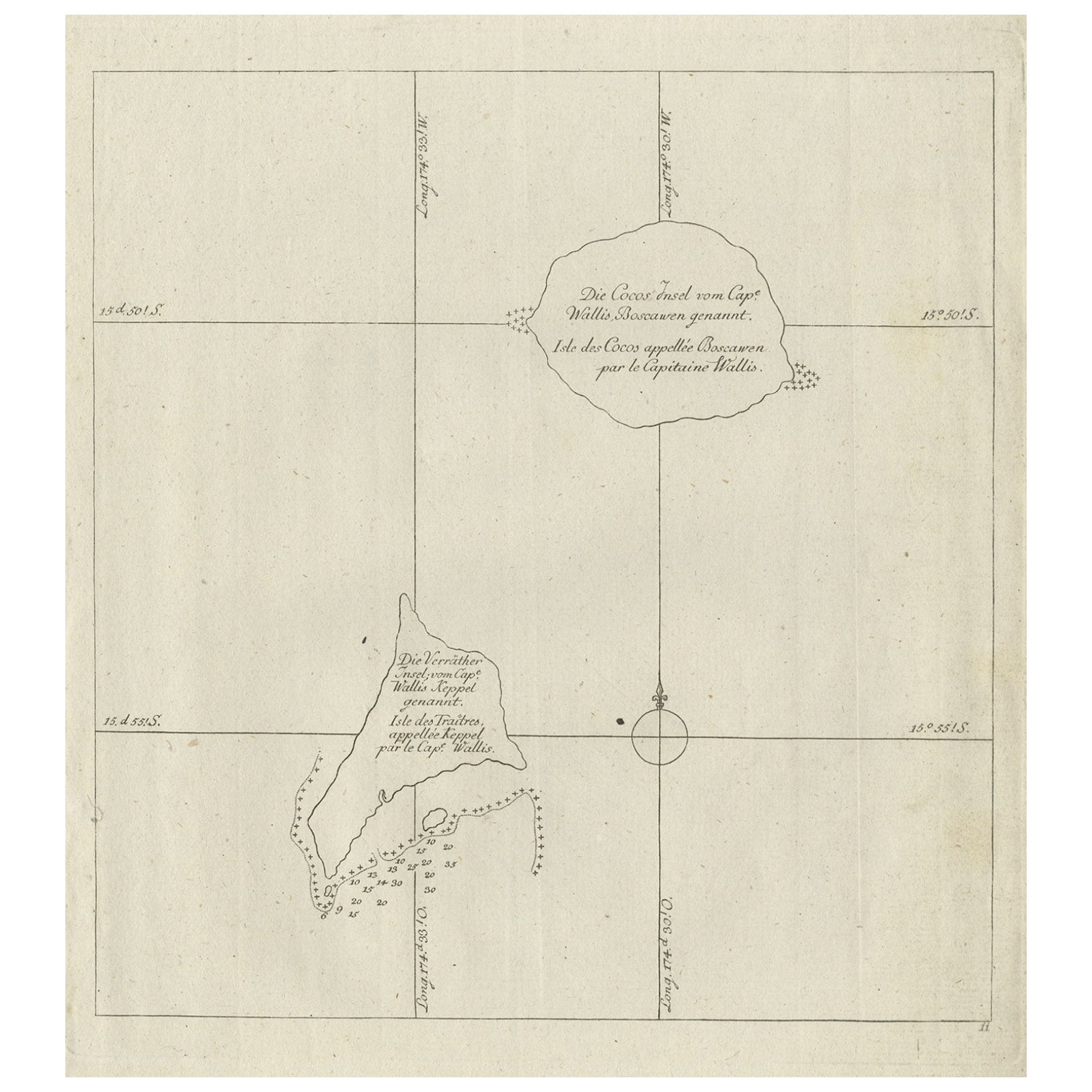
Antique Map of the Cocos or Keeling Islands, 1778
Located in Langweer, NL
Antique map titled 'Die Cocos Insel vom Capt. Wallis Bosawren. Die Verrather Islel von Capt. Wallis Keppel Genannt'. Also with French subtitles. Old map of the Cocos or Keeling Islan...
Category
Antique 18th Century Maps
Materials
Paper
$277 Sale Price
20% Off
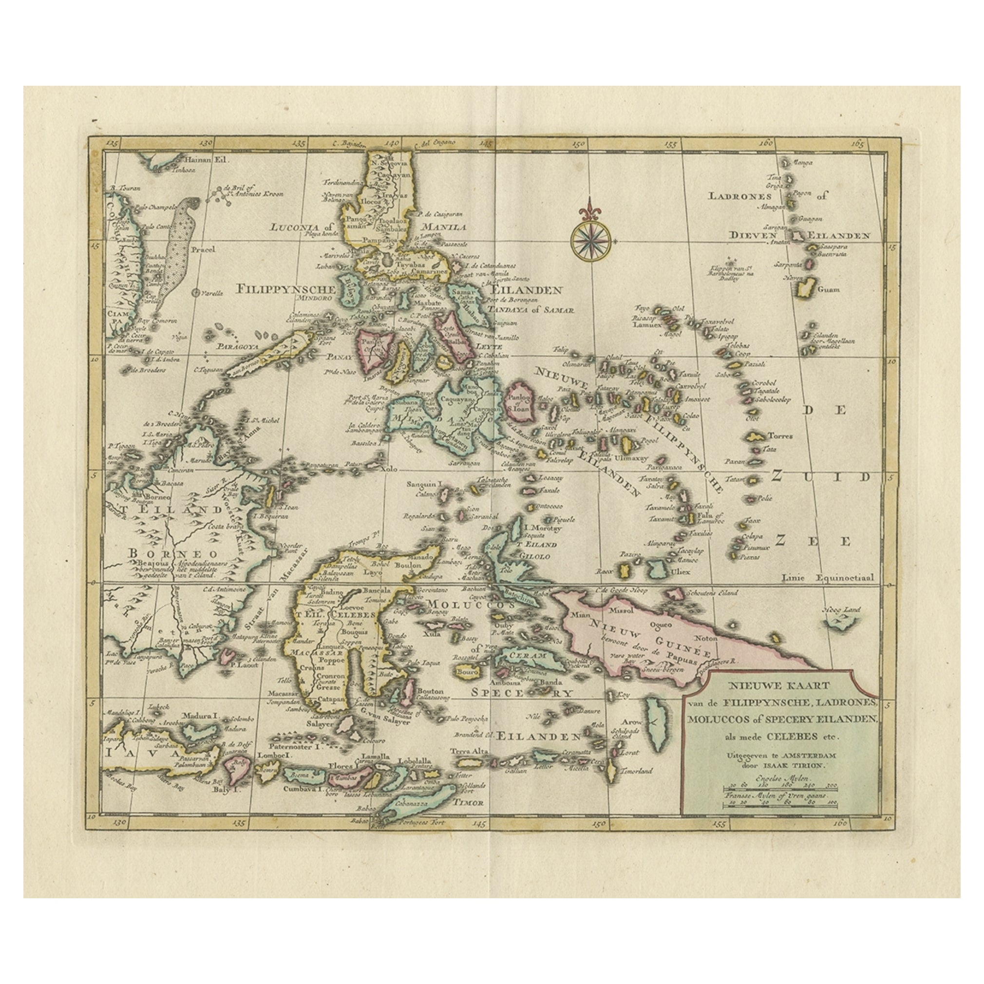
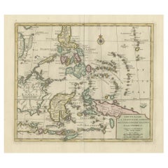
Old Original Map of the Philippines and Part of Indonesia 'Spice Islands', 1744
Located in Langweer, NL
Antique map titled 'Nieuwe Kaart van de Filippynsche, Ladrones, Moluccos of Specery Eilanden, als mede Celebes etc'.
Old map of the Philippines and part of Indonesia. Originates ...
Category
Antique 1740s Maps
Materials
Paper
$891 Sale Price
20% Off
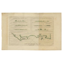
Antique Map of New Ireland, 1774
Located in Langweer, NL
Antique print titled 'Neu Irrland (..)'. Antique map of New Ireland with 7 coastal profiles, Papua New Guinea. Originates from 'Geschichte der See-Reisen u...
Category
Antique 18th Century Maps
Materials
Paper

$277 Sale Price
20% Off
Old Map of the Philippines and Part of Indonesia 'Spice Islands', 1744
Located in Langweer, NL
Antique map titled 'Nieuwe Kaart van de Filippynsche, Ladrones, Moluccos of Specery Eilanden, als mede Celebes etc'.
Old map of the Philippines and part of Indonesia. Originates ...
Category
Antique 1740s Maps
Materials
Paper

$632 Sale Price
20% Off
Antique Map of New Ireland Island in the Bismarck Archipelago, New Guinea, 1772
Located in Langweer, NL
Antique map titled 'Nova Hibernia'. Antique map of New Ireland, an island in the Bismarck Archipelago, New Guinea. Lying just north of New Britain, from which it is separated by St. ...
Category
Antique 18th Century Maps
Materials
Paper
$210 Sale Price
20% Off
You May Also Like
Antique French Map of Asia Including China Indoneseia India, 1783
Located in Amsterdam, Noord Holland
Very nice map of Asia. 1783 Dedie au Roy.
Additional information:
Country of Manufacturing: Europe
Period: 18th century Qing (1661 - 1912)
Condition: Overall Condition B (Good Used)...
Category
Antique 18th Century European Maps
Materials
Paper

$648 Sale Price
20% Off
Original Antique Map of South East Asia by Thomas Clerk, 1817
Located in St Annes, Lancashire
Great map of South East Asia
Copper-plate engraving
Drawn and engraved by Thomas Clerk, Edinburgh.
Published by Mackenzie And Dent, 1817
Unframed.
Category
Antique 1810s English Maps
Materials
Paper

West Coast of Africa, Guinea & Sierra Leone: An 18th Century Map by Bellin
By Jacques-Nicolas Bellin
Located in Alamo, CA
Jacques Bellin's copper-plate map entitled "Partie de la Coste de Guinee Dupuis la Riviere de Sierra Leona Jusquau Cap das Palmas", depicting the coast of Guinea and Sierra Leone in ...
Category
Antique Mid-18th Century French Maps
Materials
Paper

1654 Joan Blaeu Map the Sutherland, Scotland, Entitled "Southerlandia, "Ric0007
Located in Norton, MA
1654 Joan Blaeu map of the
Sutherland, Scotland, entitled
"Southerlandia,"
Hand Colored
Ric0007
Description:
Lovely map centered on Sedan and D...
Category
Antique 17th Century Dutch Maps
Materials
Paper

California, Alaska and Mexico: 18th Century Hand-Colored Map by de Vaugondy
By Didier Robert de Vaugondy
Located in Alamo, CA
This is an 18th century hand-colored map of the western portions of North America entitled "Carte de la Californie et des Pays Nord-Ouest separés de l'Asie par le détroit d'Anian, ex...
Category
Antique 1770s French Maps
Materials
Paper

Original Antique Map of South America. C.1780
Located in St Annes, Lancashire
Great map of South America
Copper-plate engraving
Published C.1780
Two small worm holes to left side of map
Unframed.
Category
Antique Early 1800s English Georgian Maps
Materials
Paper

More Ways To Browse
Captain Cook
Philippines Antique
3 Dolphins
George Cook
Antique Map Of The Philippines
Persian Maps
Antique Map Of The Philippines
Large Map Of Italy
Used Marine Compass
West Indies Colonial
Antique Pamphlets
Sicily Map
Thailand Map
Antique Maps Of Russian Empire
Antique Navigational Tools
Australian Colonial
Antique German Compass
Key Trade Sign