Items Similar to Saint Domingue Map 1793 – Colonial Haiti and Dominican Republic Plan


Video Loading
Want more images or videos?
Request additional images or videos from the seller
1 of 11
Saint Domingue Map 1793 – Colonial Haiti and Dominican Republic Plan
$1,146.14
£845.26
€960
CA$1,584.13
A$1,761.66
CHF 924.47
MX$21,482.62
NOK 11,685.58
SEK 10,955.70
DKK 7,308.63
About the Item
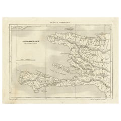
1793 Map of Saint Domingue (Haiti and DR) – Colonial Island Plan
This antique map is titled “A Map of the Island of St. Domingo” and dates from circa 1793. It depicts the entire island of Hispaniola, comprising modern-day Haiti and the Dominican Republic, at a crucial time during the late 18th century when Saint Domingue (Haiti) was France’s richest colony and on the eve of the Haitian Revolution.
This map of the Island of St. Domingo was published in Bryan Edwards’ 'The History, Civil and Commercial, of the British West Indies', first issued in 1793.
The map was commissioned by Bryan Edwards for inclusion in his work. Most maps in this publication were engraved by Samuel John Neele (1758–1824), a well-known London engraver who specialised in clear and precise cartographic engravings for atlases and historical books of the period.
Therefore, the maker details are:
Creator: Commissioned by Bryan Edwards
Engraver: Most likely Samuel John Neele, London
Publication: The History, Civil and Commercial, of the British West Indies, 1793
The engraving shows in fine detail the coastal settlements, rivers, capes, mountain ranges, and internal roads. Major towns and ports are labelled along both the French-controlled western portion (Saint Domingue) and the Spanish-controlled eastern portion (Santo Domingo). The map also includes surrounding features such as the western tip of Cuba at top left and the island of Tortuga off the northern coast. Notable bays like the Gulf of Gonâve, Port-au-Prince Bay, and Samaná Bay are clearly marked.
During the period this map was published, Saint Domingue was the most profitable colony in the world, known for its extensive sugar and coffee plantations reliant on enslaved African labour. Within a decade, the colony would experience the Haitian Revolution (1791–1804), the only successful slave revolt in history leading to the establishment of Haiti as the first Black republic and the second independent nation in the Americas after the United States.
The engraving provides a valuable historical record of settlements and geography just prior to these transformative events. It would have been published in an important historical or colonial reference work for British and European readers interested in Caribbean economic and political affairs.
Condition:
Good condition for its age. Clean impression with strong engraved lines. Original fold lines as issued, with a few minor fold separations repaired on verso. Some light toning and handling creases, mainly in margins, not affecting the printed area. No staining or tears within the engraved image. Fully suitable for framing.
Framing tips:
Frame this map in a thin black or dark wood moulding to maintain a classic archival look. Use an off-white or light cream museum mat to draw attention to its engraved details and allow space for fold depth if float mounted. UV-protective glazing is recommended to preserve the paper and prevent light damage while displaying its fine historic cartography.
- Dimensions:Height: 19.1 in (48.5 cm)Width: 31.89 in (81 cm)Depth: 0.01 in (0.2 mm)
- Materials and Techniques:Paper,Engraved
- Place of Origin:
- Period:
- Date of Manufacture:1793
- Condition:Good condition for its age. Clean impression with strong engraved lines. Original fold lines as issued, with a few minor fold separations repaired on verso. Some light toning and handling creases, mainly in margins, not affecting the printed area.
- Seller Location:Langweer, NL
- Reference Number:Seller: BG-13306-1-161stDibs: LU3054345663652
About the Seller
5.0
Recognized Seller
These prestigious sellers are industry leaders and represent the highest echelon for item quality and design.
Platinum Seller
Premium sellers with a 4.7+ rating and 24-hour response times
Established in 2009
1stDibs seller since 2017
2,577 sales on 1stDibs
Typical response time: <1 hour
- ShippingRetrieving quote...Shipping from: Langweer, Netherlands
- Return Policy
Authenticity Guarantee
In the unlikely event there’s an issue with an item’s authenticity, contact us within 1 year for a full refund. DetailsMoney-Back Guarantee
If your item is not as described, is damaged in transit, or does not arrive, contact us within 7 days for a full refund. Details24-Hour Cancellation
You have a 24-hour grace period in which to reconsider your purchase, with no questions asked.Vetted Professional Sellers
Our world-class sellers must adhere to strict standards for service and quality, maintaining the integrity of our listings.Price-Match Guarantee
If you find that a seller listed the same item for a lower price elsewhere, we’ll match it.Trusted Global Delivery
Our best-in-class carrier network provides specialized shipping options worldwide, including custom delivery.More From This Seller
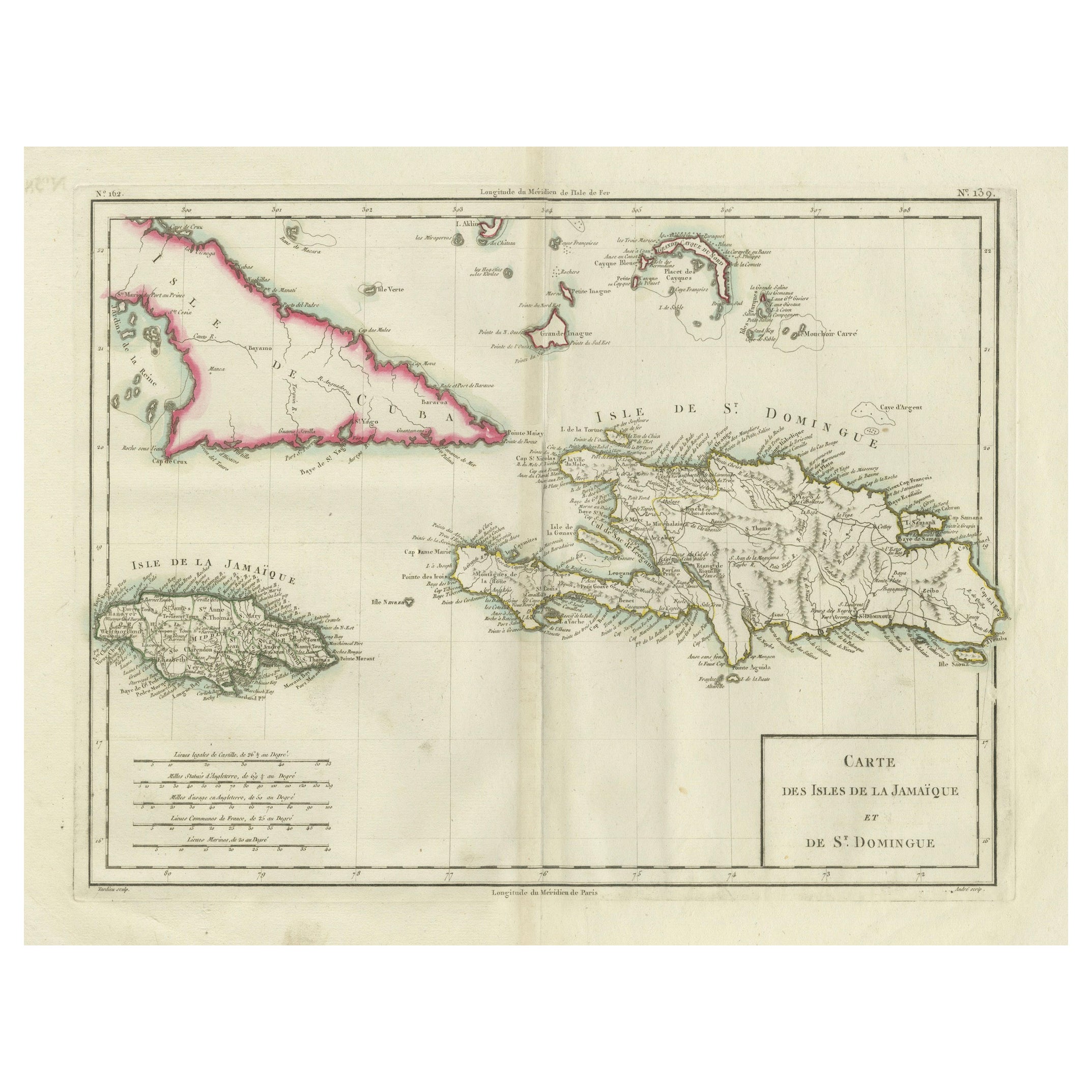
View AllAntique Map of Jamaica and Hispaniola (Saint-Domingue and Santo Domingo), 1802
Located in Langweer, NL
This is an original antique map titled "Carte des Isles de la Jamaïque et de St. Domingue," depicting the islands of Jamaica and Saint-Domingue (modern-day Haiti and the Dominican Re...
Category
Antique Early 1800s Maps
Materials
Paper

$534 Sale Price
20% Off
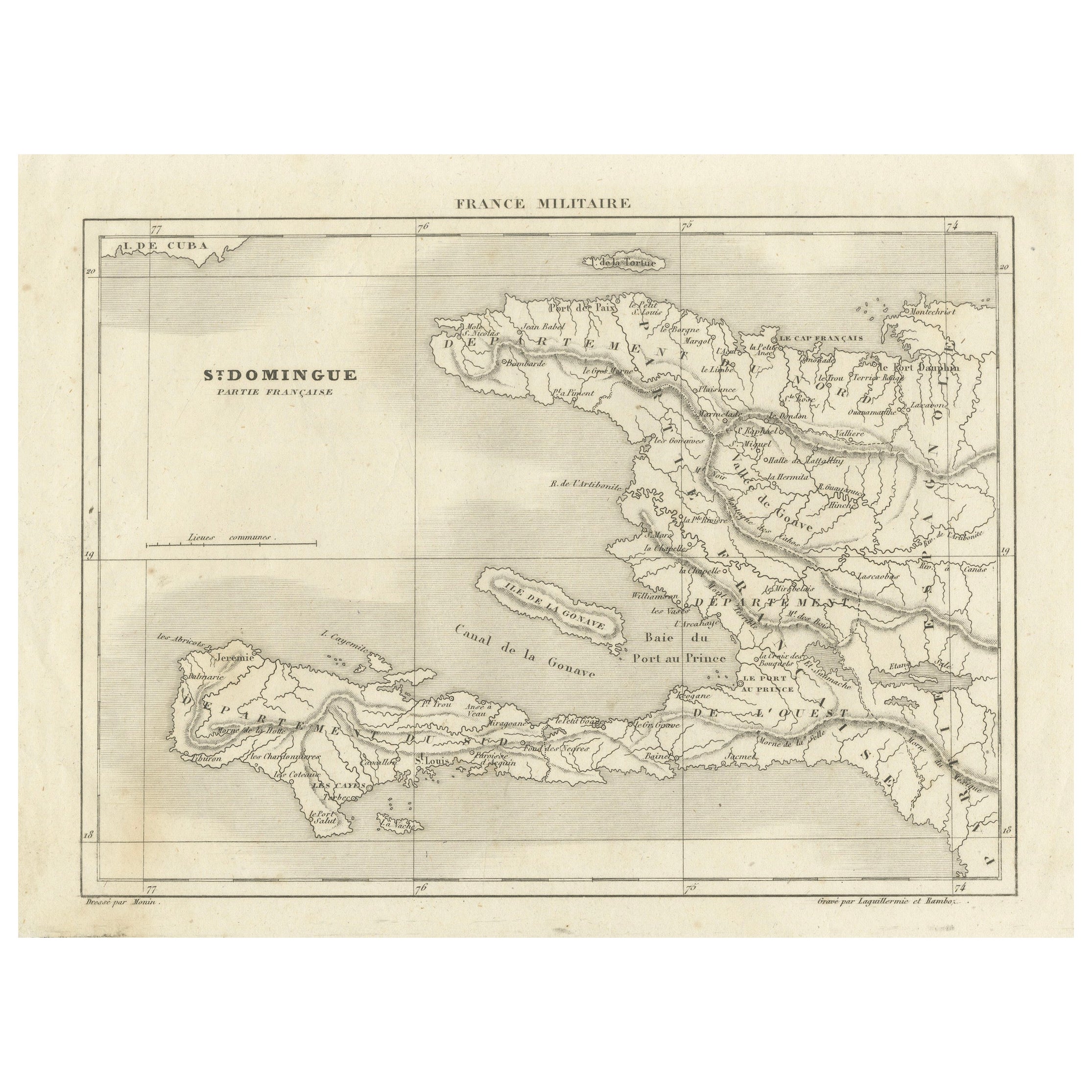
Saint-Domingue (French Section): 18th Century Map from France Militaire Series
Located in Langweer, NL
This map is titled "St. Domingue (Partie Française)" and is part of the France Militaire series. It focuses on the French portion of Saint-Domingue, which corresponds to modern-day H...
Category
Antique 1790s Maps
Materials
Paper
$114 Sale Price
20% Off
Authentic Antique Map of the Caribbean, Gulf Coast and Central America, 1787
Located in Langweer, NL
Antique map titled 'Les Isles Antilles et le Golfe du Méxique'. Original old map of the Caribbean, Gulf Coast and Central America. With inset map of Bermuda...
Category
Antique Late 18th Century Maps
Materials
Paper

$296 Sale Price
20% Off
Free Shipping
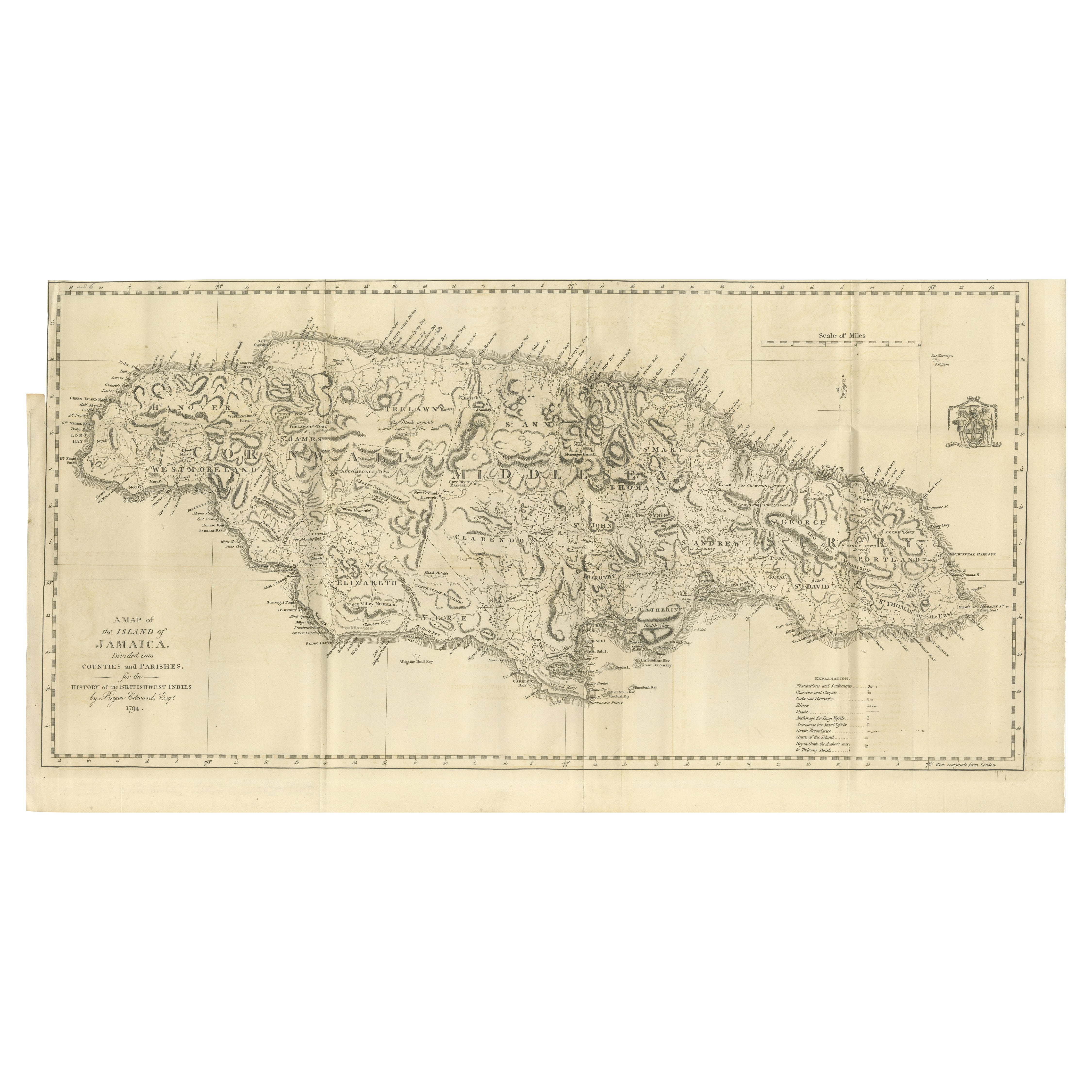
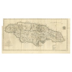
1794 Map of Jamaica by Bryan Edwards – Parishes, Plantations, Settlements
Located in Langweer, NL
1794 Bryan Edwards Map of Jamaica – Parishes, Plantations, Settlements
This is an important antique map titled “A Map of the Island of Jamaica, Divided into Counties and Parishes,” created by Bryan Edwards in 1794. It was published in the second edition of his influential work *The History of the British West Indies*, which provided detailed insights into the geography, society, and economy of the Caribbean at the height of British colonial influence.
The map meticulously depicts Jamaica divided into its traditional counties and parishes, each shaded to aid visual differentiation. Major settlements are clearly labelled, including Kingston, Montego Bay, Spanish Town, and Falmouth. The island’s intricate network of rivers, mountains, and coastal features are rendered with careful hachure and stipple shading to indicate elevation and terrain. Edwards uses small circular symbols to denote the locations of numerous sugar plantations that formed the backbone of Jamaica’s economy during this period, each plantation representing not only agricultural wealth but also the grim history of enslaved African labour central to the island’s prosperity.
Further notations identify churches, barracks, forts, and ports, demonstrating the comprehensive utility of this map for historical research into colonial infrastructure. The map even marks Bryan...
Category
Antique Late 18th Century English Maps
Materials
Paper
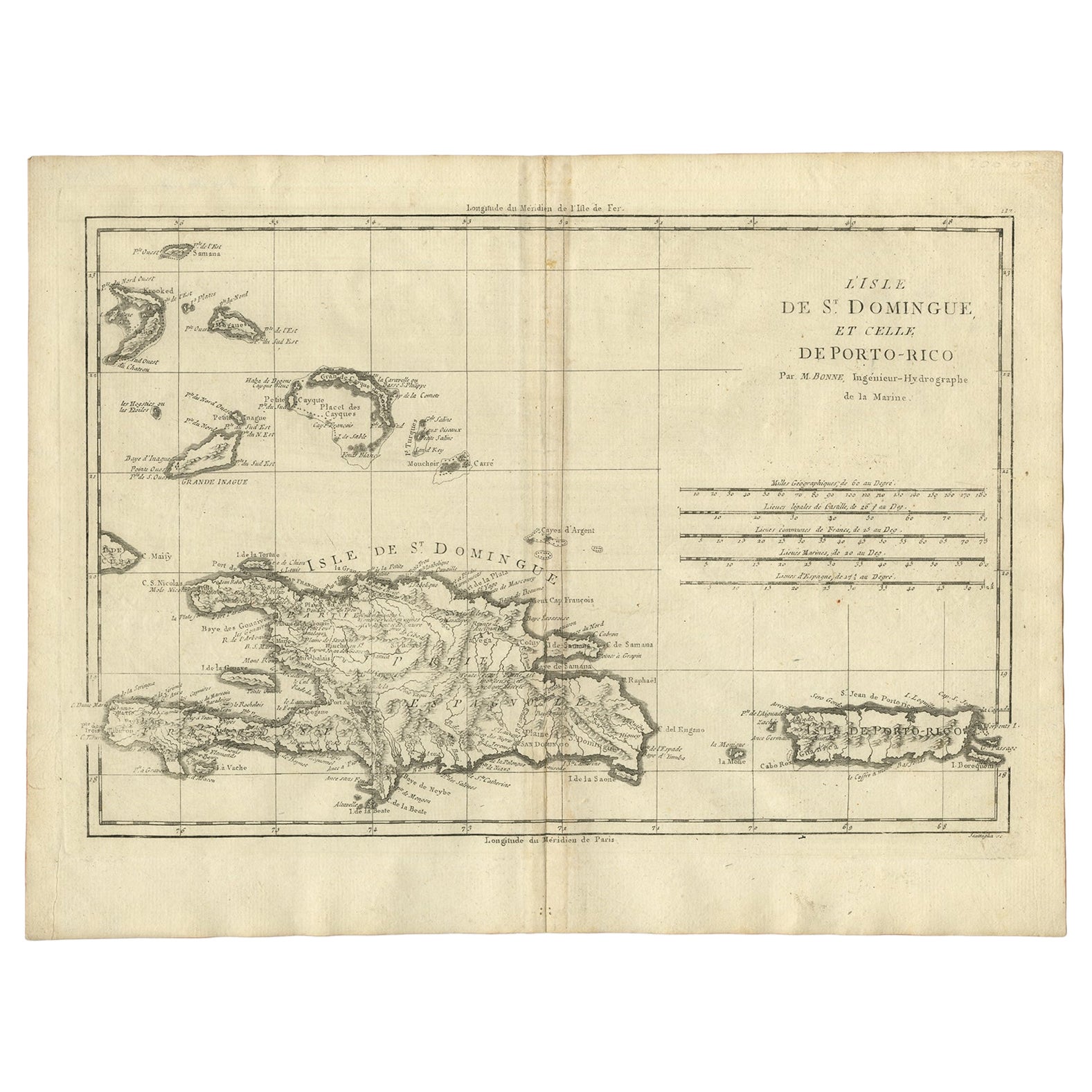
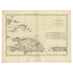
Detailed Antique Map of Santa Domingo, Puerto Rico, Eastern Bahamas, ca. 1780
Located in Langweer, NL
Description: Antique map titled 'L'Isle De St. Domingue, et celle De Porto-Rico.'
Detailed map of Santa Domingo, Puerto Rico, etc. Includes substanti...
Category
Antique 1780s Maps
Materials
Paper
$668 Sale Price
20% Off
Martinique Map by Rigobert Bonne – French Antique Map, c.1768
Located in Langweer, NL
Map of Martinique by Rigobert Bonne, circa 1768
This is a detailed antique map of Martinique titled “Isle de la Martinique,” engraved by Rigobert Bonne around 1768 for the Atlas Encyclopédique. Bonne, a renowned French hydrographer and successor to Bellin, is celebrated for his scientifically precise and elegantly engraved maps.
The map shows Martinique with its mountainous interior, rivers, and settlements labelled, including Fort Royal, Fort St. Pierre, Le Marin, and Le Prêcheur. Coastal features, bays, and capes are marked, along with anchorages important for maritime navigation in the 18th century. The depiction includes relief shown pictorially, characteristic of Bonne’s cartographic style, enhancing both geographic understanding and aesthetic appeal.
This copperplate engraving retains original hand colouring outlining the coastlines in delicate blue and brown tones, typical for the period. It served as a key reference for scholars, navigators, and colonial administrators during France’s colonial presence in the Caribbean.
Condition:
Good condition overall. A strong impression with bright, original hand-colour outlines. General age toning, faint offsetting, and a vertical fold as issued in the atlas. Margins ample all around for framing.
Framing suggestions:
This historic Caribbean map...
Category
Antique 1760s French Maps
Materials
Paper

You May Also Like
Original Antique Map of Central America / Florida, Arrowsmith, 1820
Located in St Annes, Lancashire
Great map of Central America.
Drawn under the direction of Arrowsmith.
Copper-plate engraving.
Published by Longman, Hurst, Rees, Orme and Brown, 1820
Unframed.
Category
Antique 1820s English Maps
Materials
Paper

Map Colonies Francaises Martinique, 1845
Located in BUNGAY, SUFFOLK
Colonies Francaises, Martinique, Amerique DU SUD
Geographie et Statistique par V.Levasseur. Ing'r Geographe.
Illustre par Raymond Bonheur, peintre.
Grave par Laguihermie, Rue St...
Category
Antique 19th Century French Maps
Materials
Paper

Large Original Antique Map of The West Indies by Sidney Hall, 1847
Located in St Annes, Lancashire
Great map of The West Indies
Drawn and engraved by Sidney Hall
Steel engraving
Original colour outline
Published by A & C Black. 1847
Unframed
Free shipping.
Category
Antique 1840s Scottish Maps
Materials
Paper

Map Of Martinique - Etching - 19th Century
Located in Roma, IT
Map Of Martinique is an etching realized by an anonymous engraver of the 19th Century.
Printed within the series "France Pittoresque" at the top center.
The state of preservation o...
Category
19th Century Modern Figurative Prints
Materials
Etching

St. Christophe (St. Kitts): Bellin 18th Century Hand Colored Map
Located in Alamo, CA
Jacques Bellin's copper-plate map of the Caribbean island of Saint Kitts entitled "Carte De De l'Isle St. Christophe Pour servir á l'Histoire Genle. des V...
Category
1740s Other Art Style Landscape Prints
Materials
Engraving

Antique 1765 Wine Country Folding Map of France, Bordeau etc.
Located in Paonia, CO
Route du Carosse de Bordeaux, part de Paris tous les Mardis a 11 matin. a et pafse 1765 is a comprehensive map with two routes through the wine country of France starting in Paris going south...
Category
1760s Other Art Style Landscape Prints
Materials
Etching

More Ways To Browse
French Colonial Furniture
Cream And Sugar
Antique Label Maker
Africa Colonial
West Indies Antique Furniture
Spanish Wood Saint
French Santos
Antique Wood Santos
Spanish Santos
18th Century Santos
Haitian Wood
Antique Plantation Furniture
Antique Wood Santos Santo
Spanish Colonial Santos
Curved Velvet Couch
Velvet Curved Sofa
Wood Round Coffee Tables
Oak Brutalist