Items Similar to Small Antique Map of the European Turkey, Greece & Ionian Islands – c.1860


Want more images or videos?
Request additional images or videos from the seller
1 of 10
Small Antique Map of the European Turkey, Greece & Ionian Islands – c.1860
$113.39
$141.7420% Off
£85.20
£106.5020% Off
€96
€12020% Off
CA$156.14
CA$195.1820% Off
A$174.75
A$218.4420% Off
CHF 91.48
CHF 114.3520% Off
MX$2,122.93
MX$2,653.6620% Off
NOK 1,161.52
NOK 1,451.9020% Off
SEK 1,096.10
SEK 1,370.1220% Off
DKK 730.66
DKK 913.3220% Off
About the Item
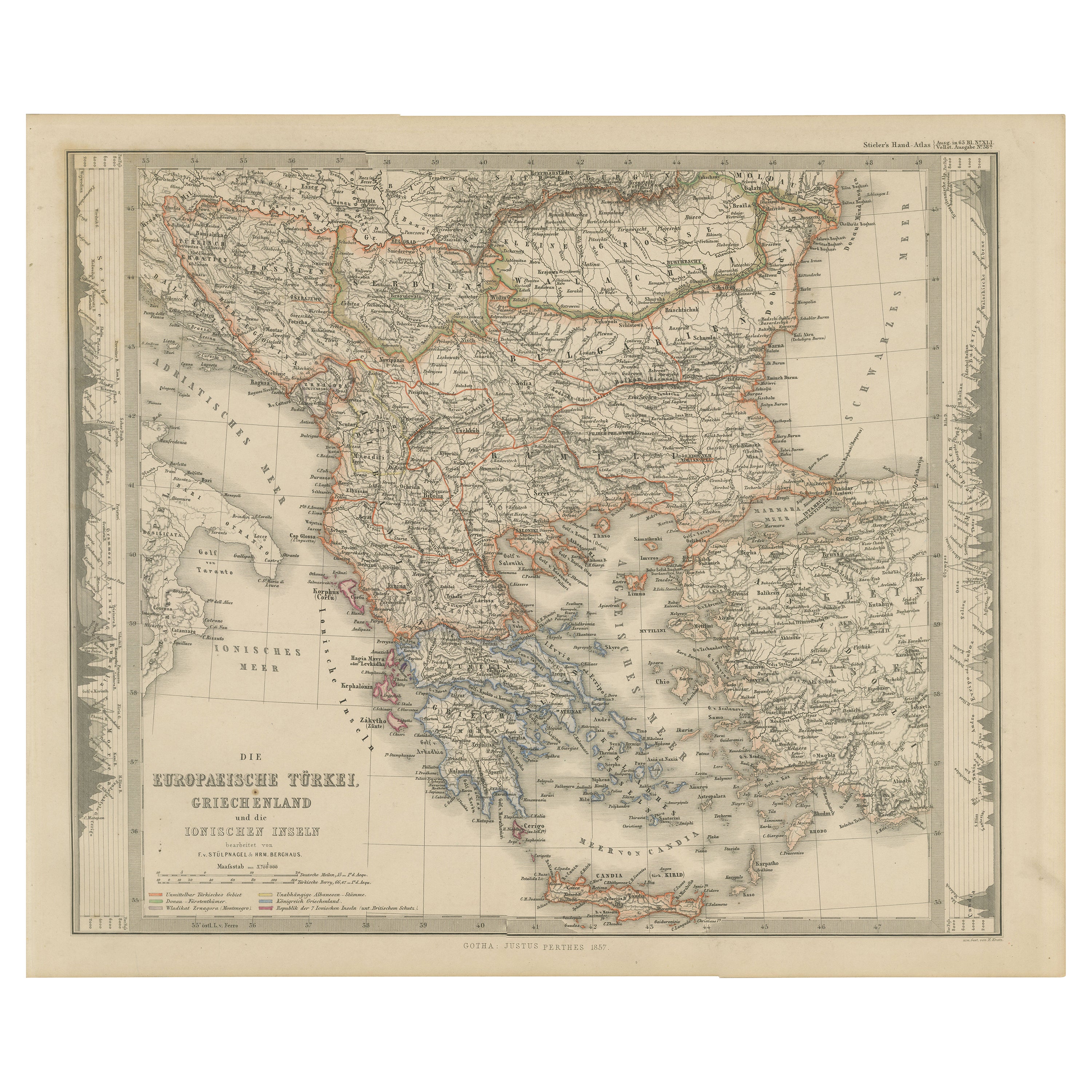
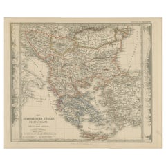
Antique Map of the European Turkey, Greece & Ionian Islands – Stieler, c.1860
Original antique map titled *Die Europaeische Türkei, Griechenland und die Ionischen Inseln* (European Turkey, Greece and the Ionian Islands), published by Justus Perthes in Gotha, circa 1860. This finely engraved map comes from Stieler’s Schul-Atlas (Plate No. 22), and details the political and geographic landscape of the Balkan Peninsula, including parts of modern-day Greece, Albania, North Macedonia, Bulgaria, Serbia, Montenegro, Bosnia, and European Turkey.
The map features original hand colouring outlining regional boundaries such as Ottoman territories, vassal states, and areas under foreign protection. Coastal cities, mountain ranges, and islands—including Crete (Kreta), Corfu, and the Cyclades—are clearly depicted. An elevation profile is included along the right margin, with key shown lower left.
A striking piece of 19th-century European cartography, ideal for collectors, historians, and interior decorators.
Condition: Good antique condition. Some minor age spots, toning and dirt to margins due to handling, but strong impression with fine detail. Centre fold as issued.
Tips for framing: Use acid-free matting and UV-protective glass to preserve the map. Choose a classic frame in dark wood or black. Window matting or float mounting is ideal to show plate marks. Avoid glue; use archival corners or hinges for reversibility.
Keywords: antique map Greece, Ottoman Empire map, European Turkey map, Ionian Islands, 19th century map, Stieler map, Balkan antique map, map of Greece 1800s, Justus Perthes, Stieler’s Atlas, engraved map, hand colored map, historical map, Greece wall art, rare map, gift for historian, travel map decor
Shipping: Ships flat in archival packaging with full insurance and tracking. Suitable for framing.
- Dimensions:Height: 9.26 in (23.5 cm)Width: 11.66 in (29.6 cm)Depth: 0.01 in (0.2 mm)
- Materials and Techniques:
- Period:
- Date of Manufacture:circa 1860
- Condition:Condition: Good antique condition. Some minor age spots, toning and dirt to margins due to handling, but strong impression with fine detail. Centre fold as issued.
- Seller Location:Langweer, NL
- Reference Number:Seller: BG-033381stDibs: LU3054344633152
About the Seller
5.0
Recognized Seller
These prestigious sellers are industry leaders and represent the highest echelon for item quality and design.
Platinum Seller
Premium sellers with a 4.7+ rating and 24-hour response times
Established in 2009
1stDibs seller since 2017
2,534 sales on 1stDibs
Typical response time: <1 hour
- ShippingRetrieving quote...Shipping from: Langweer, Netherlands
- Return Policy
Authenticity Guarantee
In the unlikely event there’s an issue with an item’s authenticity, contact us within 1 year for a full refund. DetailsMoney-Back Guarantee
If your item is not as described, is damaged in transit, or does not arrive, contact us within 7 days for a full refund. Details24-Hour Cancellation
You have a 24-hour grace period in which to reconsider your purchase, with no questions asked.Vetted Professional Sellers
Our world-class sellers must adhere to strict standards for service and quality, maintaining the integrity of our listings.Price-Match Guarantee
If you find that a seller listed the same item for a lower price elsewhere, we’ll match it.Trusted Global Delivery
Our best-in-class carrier network provides specialized shipping options worldwide, including custom delivery.More From This Seller
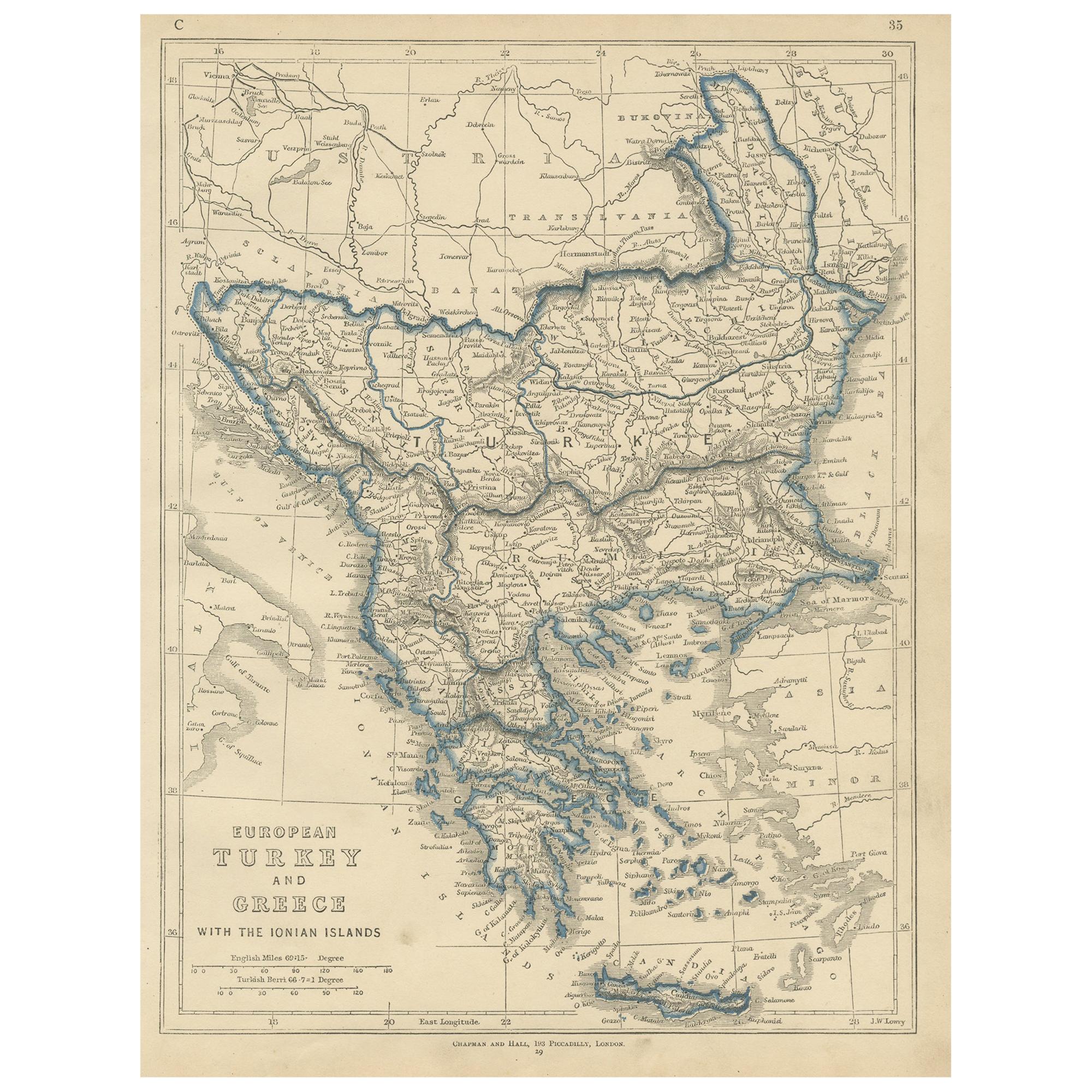
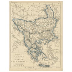
View AllEuropean Turkey and Greece Map – Balkans and Ionian Islands 1857
Located in Langweer, NL
European Turkey and Greece Map – Balkans and Ionian Islands 1857
This detailed antique print shows “Die Europäische Türkei, Griechenland und die Ionische...
Category
Antique Mid-19th Century German Maps
Materials
Paper
Antique Map of Turkey and Greece, 1852
Located in Langweer, NL
Antique map titled 'Europisch Turkije en Griekenland'. Map of Turkey in Europe and Greece. This map originates from 'School-Atlas van alle deelen der Aar...
Category
Antique 19th Century Maps
Materials
Paper

$113 Sale Price
20% Off
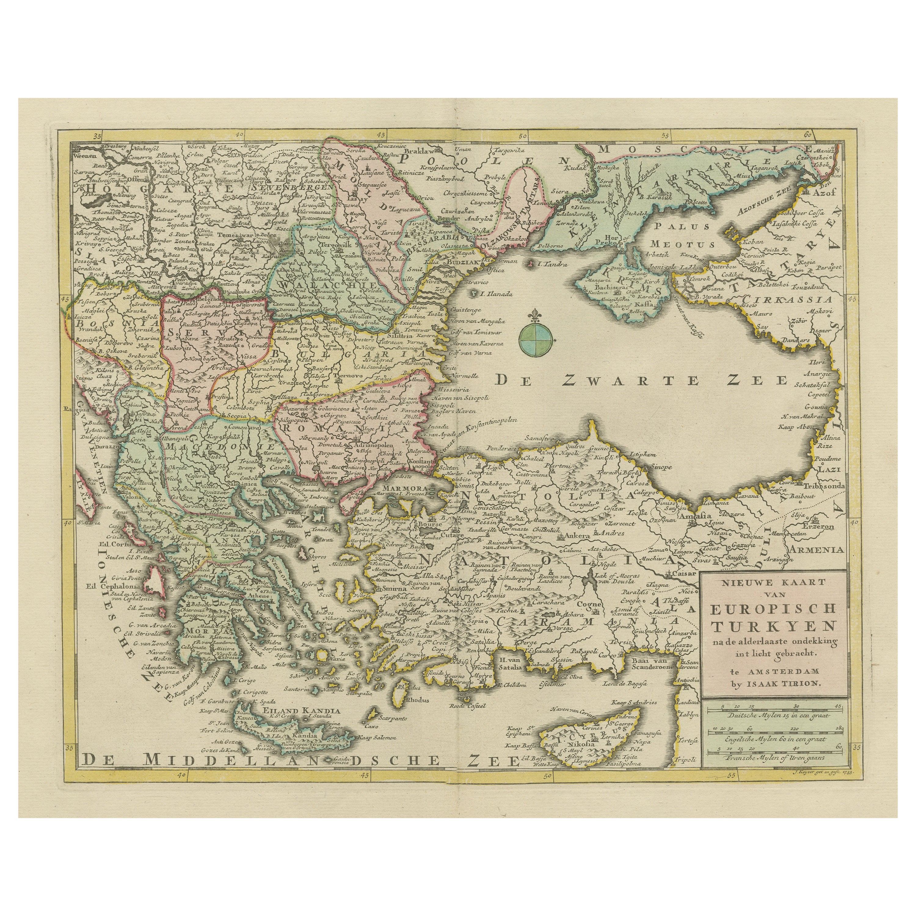
Antique Map of European Turkey and Greece by Lowry '1852'
Located in Langweer, NL
Antique map titled 'European Turkey and Greece with the Ionian Islands'. Original map of European Turkey and Greece. This map originates from 'Lowry's table Atlas constructed and eng...
Category
Antique Mid-19th Century Maps
Materials
Paper
$94 Sale Price
20% Off
Antique Map of Turkey and Greece by Petri, c.1873
Located in Langweer, NL
Antique map titled 'Europisch Turkije en Griekenland'. Old map depicting Turkey in Europe and Greece. This map originates from 'School-Atlas van alle Deelen der Aarde'.
Artists and...
Category
Antique 19th Century Maps
Materials
Paper

Antique Map of Greece, Turkey and surroundings with original coloring
Located in Langweer, NL
Antique map titled 'Nieuwe Kaart van Europisch Turkyen na de alderlaatste ontdekking in t licht gebracht'. Antique map of Greece with Crete and Cyprus, Turkey and the Black Sea. Publ...
Category
Antique Mid-18th Century Maps
Materials
Paper

$652 Sale Price
20% Off
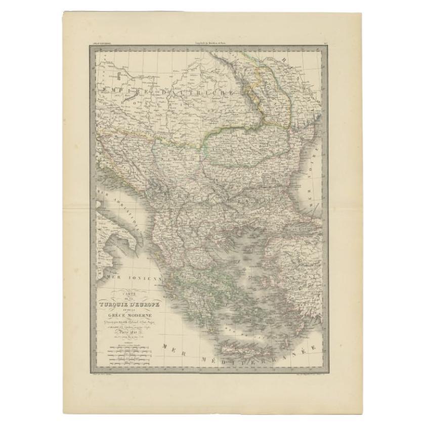
Antique Map of Turkey and Greece, 1842
By Pierre M. Lapie
Located in Langweer, NL
Antique map titled 'Carte de la Turquie d'Europe et de la Grèce Moderne'. Map of Turkey and Greece. This map originates from 'Atlas universel de géographie ancienne et moderne (..)' ...
Category
Antique 19th Century Maps
Materials
Paper
$330 Sale Price
20% Off
You May Also Like
Large Original Antique Map of Cyprus. 1894
Located in St Annes, Lancashire
Superb Antique map of Cyprus
Published Edward Stanford, Charing Cross, London 1894
Original colour
Good condition
Unframed.
Free shipping
Category
Antique 1890s English Maps
Materials
Paper

Original Antique Map of Ancient Greece, Achaia, Corinth, 1786
Located in St Annes, Lancashire
Great map of Ancient Greece. Showing the region of Thessaly, including Mount Olympus
Drawn by J.D. Barbie Du Bocage
Copper plate engraving by P.F Tardieu
Original hand color...
Category
Antique 1780s French Other Maps
Materials
Paper

Map of Ancient Greece of Macedonia and... - Lithograph by Auguste Wahlen - 1844
Located in Roma, IT
Map of Ancient Greece of Macedonia and Thrace is a lithograph made by Auguste Wahlen in 1844.
Hand colored.
Good condition.
Bottom left is the original title "Carta della Grecia A...
Category
1840s Modern Figurative Prints
Materials
Lithograph

Large Original Antique Map of The Greek Islands. 1894
Located in St Annes, Lancashire
Superb Antique map of The Greek Islands
Published Edward Stanford, Charing Cross, London 1894
Original colour
Good condition
Unframed.
Free shipping
Category
Antique 1890s English Maps
Materials
Paper

Map of Greece - Etching on Paper 19th Century
Located in Roma, IT
Image dimensions: 22.2 x 27.8 cm.
Grecia is an interesting hand-colored etching on paper, realized by an anonymous artist in the first half of the XIX century.
With the inscriptions in Italian, this original print describes the geography of Greece with the great charisma of the antique maps.
In very good conditions, except for a usual yellowing of the paper at the edges and minor defects and signs of the time, and some light yellow strips...
Category
19th Century Modern Figurative Prints
Materials
Etching

18th Century Map of the Southern Balkans by Giovanni Maria Cassini
By Giovanni Maria Cassini
Located in Hamilton, Ontario
18th century map by Italian engraver Giovanni Maria Cassini (Italy 1745-1824).
Map of the Southern Balkans: Rome. Hand colored and copper engraved print done in the year 1788. It in...
Category
Antique 18th Century Italian Maps
Materials
Paper

$795 Sale Price
36% Off
More Ways To Browse
Antique European Plates
Turkey Plates
Key Greek Antique Glass
Greek Key Handle
Antique Glass Floats
Greek Key Plate
Antique Turkey Plates
Antique Crete
Turkish Wall Plates
Greek Key Ottoman
Silver Bowl Large
Down Couch
Used Lighter Art
Blue Edge Glass
Mahogany 1950s Furniture
Solid Mahogany Table
Dessert Glasses
Geometric Glass Table