Items Similar to Antique Map of Turkey and Greece by Petri, c.1873

Want more images or videos?
Request additional images or videos from the seller
1 of 6
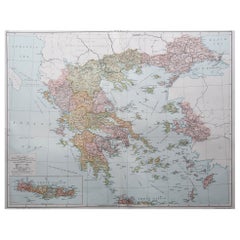
Antique Map of Turkey and Greece by Petri, c.1873
About the Item
Antique map titled 'Europisch Turkije en Griekenland'. Old map depicting Turkey in Europe and Greece. This map originates from 'School-Atlas van alle Deelen der Aarde'.
Artists and Engravers: Published by O. Petri, Rotterdam.
Condition: Good, general age-related toning. Split on folding line, please study image carefully.
Date: c.1873
Overall size: 26.2 x 32.1 cm.
Image size: 21.1 x 28.6 cm.
We sell original antique maps to collectors, historians, educators and interior decorators all over the world. Our collection includes a wide range of authentic antique maps from the 16th to the 20th centuries. Buying and collecting antique maps is a tradition that goes back hundreds of years. Antique maps have proved a richly rewarding investment over the past decade, thanks to a growing appreciation of their unique historical appeal. Today the decorative qualities of antique maps are widely recognized by interior designers who appreciate their beauty and design flexibility. Depending on the individual map, presentation, and context, a rare or antique map can be modern, traditional, abstract, figurative, serious or whimsical. We offer a wide range of authentic antique maps for any budget.
- Dimensions:Height: 12.64 in (32.1 cm)Width: 10.32 in (26.2 cm)Depth: 0 in (0.01 mm)
- Materials and Techniques:
- Period:
- Date of Manufacture:c.1873
- Condition:Condition: Good, general age-related toning. Split on folding line, please study image carefully.
- Seller Location:Langweer, NL
- Reference Number:
About the Seller
5.0
Platinum Seller
These expertly vetted sellers are 1stDibs' most experienced sellers and are rated highest by our customers.
Established in 2009
1stDibs seller since 2017
1,929 sales on 1stDibs
Typical response time: <1 hour
- ShippingRetrieving quote...Ships From: Langweer, Netherlands
- Return PolicyA return for this item may be initiated within 14 days of delivery.
More From This SellerView All
- Antique Map of Sweden and Norway by Petri, c.1873Located in Langweer, NLAntique map titled 'Zweden en Noorwegen'. Old map depicting Sweden and Norway. This map originates from 'School-Atlas van alle Deelen der Aarde'. Artists and Engravers: Published by ...Category
Antique 19th Century Maps
MaterialsPaper
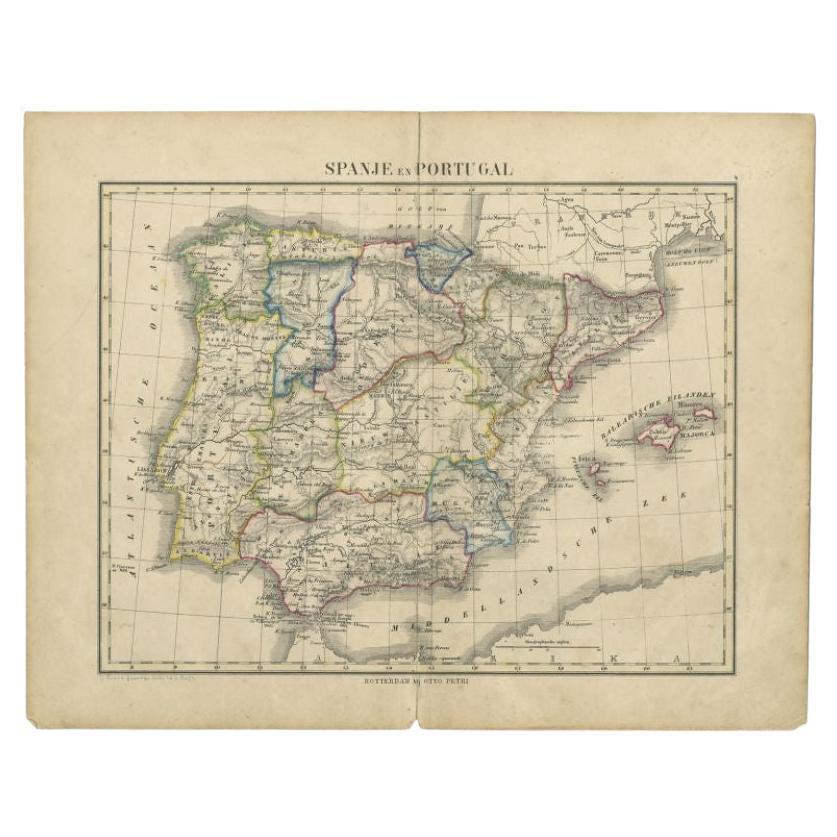
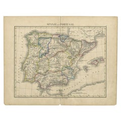
- Antique Map of Spain and Portugal by Petri, c.1873Located in Langweer, NLAntique map titled 'Spanje en Portugal'. Old map depicting Spain and Portugal. This map originates from 'School-Atlas van alle Deelen der Aarde'. Artists and Engravers: Published by ...Category
Antique 19th Century Maps
MaterialsPaper
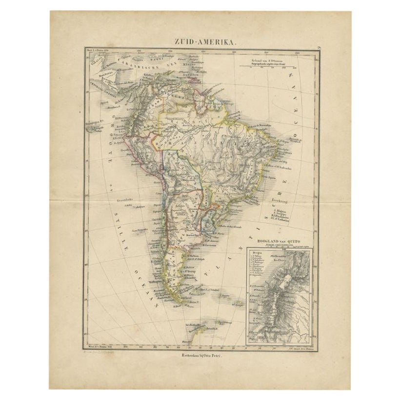
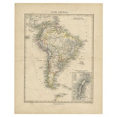
- Antique Map of South America by Petri, c.1873By Thomas KitchinLocated in Langweer, NLAntique map titled 'Zuid-Amerika'. Old map depicting South America, with an inset map of the highland of Quito. This map originates from 'School-Atlas van alle Deelen der Aarde'. Art...Category
Antique 19th Century Maps
MaterialsPaper
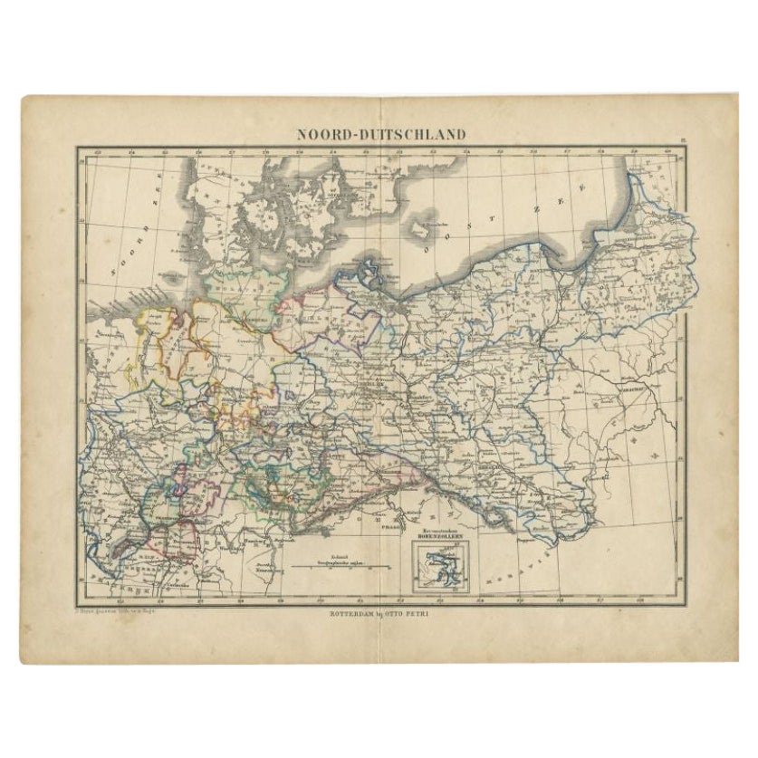
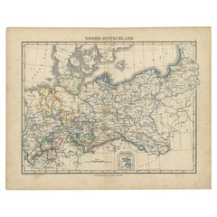
- Antique Map of Northern Germany by Petri, c.1873Located in Langweer, NLAntique map titled 'Noord-Duitschland'. Old map depicting northern Germany. This map originates from 'School-Atlas van alle Deelen der Aarde'. Artists and Engravers: Published by O. ...Category
Antique 19th Century Maps
MaterialsPaper
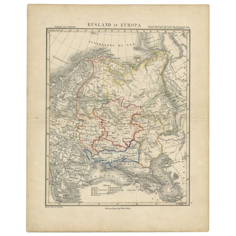
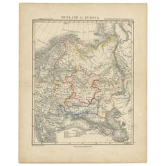
- Antique Map of Russia in Europe by Petri, c.1873Located in Langweer, NLAntique map titled 'Rusland in Europa'. Old map depicting Russia in Europe. This map originates from 'School-Atlas van alle Deelen der Aarde'. Artists and Engravers: Published by O. ...Category
Antique 19th Century Maps
MaterialsPaper
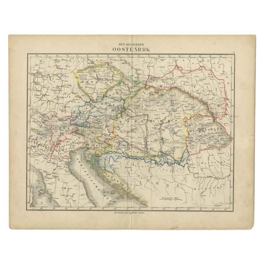
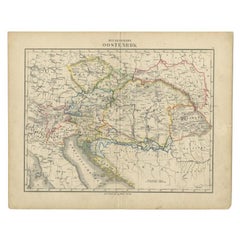
- Antique Map of the Austrian Empire by Petri, c.1873Located in Langweer, NLAntique map titled 'Het Keizerrijk Oostenrijk'. Old map depicting the Austrian Empire. This map originates from 'School-Atlas van alle Deelen der Aarde'. Artists and Engravers: Publi...Category
Antique 19th Century Maps
MaterialsPaper

You May Also Like
- 1873 "Map of the States of California and Nevada" by Chas. Drayton GibbesLocated in Colorado Springs, COPresented is Warren Holt and Charles Drayton Gibbes' 1873 “Map of California and Nevada.” This map is considered to be one of the finest large-scale ...Category
Antique 1870s American Maps
MaterialsPaper
- Original Antique Map of Ancient Greece, Achaia, Corinth, 1786Located in St Annes, LancashireGreat map of Ancient Greece. Showing the region of Thessaly, including Mount Olympus Drawn by J.D. Barbie Du Bocage Copper plate engraving by P.F Tardieu Original hand color...Category
Antique 1780s French Other Maps
MaterialsPaper
- Original Antique Map of Ancient Greece- Boeotia, Thebes, 1787Located in St Annes, LancashireGreat map of Ancient Greece. Showing the region of Boeotia, including Thebes Drawn by J.D. Barbie Du Bocage Copper plate engraving by P.F T...Category
Antique 1780s French Other Maps
MaterialsPaper
- Original Antique Map of Ancient Greece, Phocis, Gulf of Corinth, 1787Located in St Annes, LancashireGreat map of Ancient Greece. Showing the region of Phocis, including the Gulf of Corinth Drawn by J.D. Barbie Du Bocage Copper plate engraving by P.F Tardieu Original hand c...Category
Antique 1780s French Other Maps
MaterialsPaper
- Large Original Vintage Map of Greece, circa 1920Located in St Annes, LancashireGreat map of Greece Original color. Good condition Published by Alexander Gross Unframed.Category
Vintage 1920s English Maps
MaterialsPaper
- 1907 Map of Colorado, Antique Topographical Map, by Louis NellLocated in Colorado Springs, COThis highly detailed pocket map is a topographical map of the state of Colorado by Louis Nell from 1907. The map "has been complied from all availabl...Category
Antique Early 1900s American Maps
MaterialsPaper


Recently Viewed
View AllMore Ways To Browse
Antique Map Livonia
Antique Maps Denver
Menorca Map
Sumba Map
Antique Cabbage Cutter
Wyld Globes
Antique Life Buoy
Antique Life Buoys
Atlantis Antique
Map Of Armenia
Gambia Antique Map
Victor Levasseur On Sale
Nova Totius
Antique Barbie Furniture
Antique Map Dordogne
Antique Yemen
Antique Map Montreal
Antique Map Of Puerto Rico