Items Similar to Topographical and Administrative Cartography of Segovia in Spain, 1902


Want more images or videos?
Request additional images or videos from the seller
1 of 6
Topographical and Administrative Cartography of Segovia in Spain, 1902
$278.21
$347.7620% Off
£206.96
£258.7020% Off
€232
€29020% Off
CA$380.96
CA$476.2020% Off
A$423.58
A$529.4820% Off
CHF 221.17
CHF 276.4620% Off
MX$5,156
MX$6,44520% Off
NOK 2,822.03
NOK 3,527.5420% Off
SEK 2,644.11
SEK 3,305.1420% Off
DKK 1,766.09
DKK 2,207.6120% Off
Shipping
Retrieving quote...The 1stDibs Promise:
Authenticity Guarantee,
Money-Back Guarantee,
24-Hour Cancellation
About the Item
An original old map of the province of Segovia from the year 1902. Segovia is a historic area located in the central part of Spain, northwest of Madrid. Known for its rich history, architectural landmarks, and strategic importance throughout the centuries, Segovia is home to several notable sites. One of the most renowned is the Roman Aqueduct of Segovia, one of the best-preserved elevated Roman aqueducts and a symbol of the city.
Additionally, the province is characterized by a varied landscape that includes parts of the Guadarrama mountain range and the Duratón River. The map would have been used for navigation and administrative purposes, showing not only geographical features but also infrastructural elements such as roads, railways, and the boundaries of municipalities.
More about Segovia:
Segovia is a province full of historical and cultural wealth, located within the autonomous community of Castile and León in Spain. Here are some additional details and highlights:
1. **Roman Aqueduct**: Perhaps the most iconic landmark of Segovia is the Roman Aqueduct, which dates back to the late 1st or early 2nd century AD. This engineering marvel was used to transport water from the Frío River to the city and is a testament to the advanced engineering skills of the Romans.
2. **Alcázar of Segovia**: The Alcázar is a medieval castle situated on a rocky crag above the confluence of two rivers near the Guadarrama mountains. It is one of the most distinctive castle-palaces in Spain by virtue of its shape – like the bow of a ship. The Alcázar was originally built as a fortress but has served as a royal palace, a state prison, and a military academy over the centuries.
3. **Segovia Cathedral**: Known as the "Lady of the Cathedrals," it is a superb example of Gothic architecture and is located in the main square of the city, the Plaza Mayor. It was built in the mid-16th century and is noted for its size and the beauty of its interior.
4. **Cuisine**: Segovia is renowned for its traditional dishes, especially roasted suckling pig (cochinillo asado), which is a culinary staple and a must-try for visitors. The province is also known for its delicious lamb dishes and judiones de La Granja, a type of large white bean served as a stew.
5. **La Granja de San Ildefonso**: This royal palace and gardens are located in the town of San Ildefonso and are often referred to as the Versailles of Spain. The palace was the summer residence of the Spanish monarchs, and the gardens are famous for their fountains and sculpted hedges.
6. **Cultural Heritage**: The old city of Segovia and its Aqueduct have been declared a World Heritage Site by UNESCO. The city's layout is a testament to its Roman and medieval past.
7. **Natural Landscapes**: Beyond the city, the province offers a variety of landscapes, from the peaks of the Sierra de Guadarrama to the rolling plains. It provides opportunities for outdoor activities such as hiking, skiing in the nearby ski resorts, and bird watching in natural parks.
8. **Festivals and Traditions**: Segovia has a rich calendar of festivals, including religious processions during Semana Santa (Holy Week) and other celebrations that showcase its folklore and traditions.
These characteristics define Segovia as a place where history and tradition are palpable in every corner, offering a rich experience to those interested in exploring Spain's cultural and natural heritage.
- Dimensions:Height: 14.77 in (37.5 cm)Width: 20.08 in (51 cm)Depth: 0 in (0.02 mm)
- Materials and Techniques:
- Period:1900-1909
- Date of Manufacture:1902
- Condition:Good condition. Central vertical folding lines as issued. Aged paper with typically warm, yellowish-brown hue, especially around the edges. Slightly wrinkled at the middle top. Check the images carefully.
- Seller Location:Langweer, NL
- Reference Number:Seller: BG-13642-371stDibs: LU3054338032752
About the Seller
5.0
Recognized Seller
These prestigious sellers are industry leaders and represent the highest echelon for item quality and design.
Platinum Seller
Premium sellers with a 4.7+ rating and 24-hour response times
Established in 2009
1stDibs seller since 2017
2,511 sales on 1stDibs
Typical response time: <1 hour
- ShippingRetrieving quote...Shipping from: Langweer, Netherlands
- Return Policy
Authenticity Guarantee
In the unlikely event there’s an issue with an item’s authenticity, contact us within 1 year for a full refund. DetailsMoney-Back Guarantee
If your item is not as described, is damaged in transit, or does not arrive, contact us within 7 days for a full refund. Details24-Hour Cancellation
You have a 24-hour grace period in which to reconsider your purchase, with no questions asked.Vetted Professional Sellers
Our world-class sellers must adhere to strict standards for service and quality, maintaining the integrity of our listings.Price-Match Guarantee
If you find that a seller listed the same item for a lower price elsewhere, we’ll match it.Trusted Global Delivery
Our best-in-class carrier network provides specialized shipping options worldwide, including custom delivery.More From This Seller
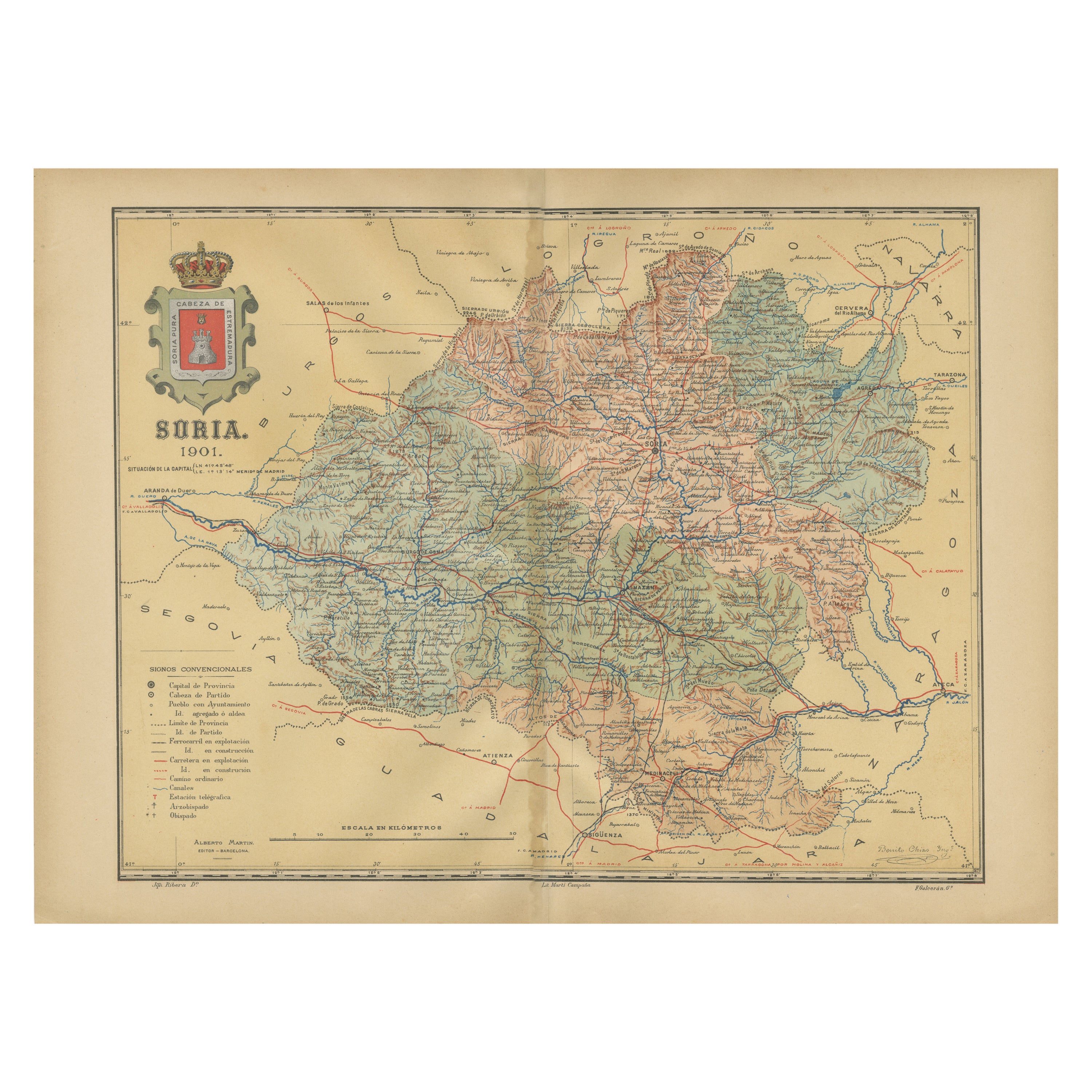
View AllMap of Soria Province, 1901: Detailed Cartography of Northeastern Spain
Located in Langweer, NL
The map is a historical map of the province of Soria from 1901.
A decorative coat of arms enhances the aesthetic of the map, signifying the historical and cultural significance of ...
Category
Antique Early 1900s Maps
Materials
Paper

$316 Sale Price
20% Off
Free Shipping
Navarra in Cartographic Detail: A 1902 Map of the Crossroads of Northern Spain
Located in Langweer, NL
The original antique map for sale shows the Spanish province of Navarra as it was in 1902. Here's a brief description and a potential title for the map:
Description:
- The map detai...
Category
Antique Early 1900s Maps
Materials
Paper

$326 Sale Price
20% Off
Free Shipping
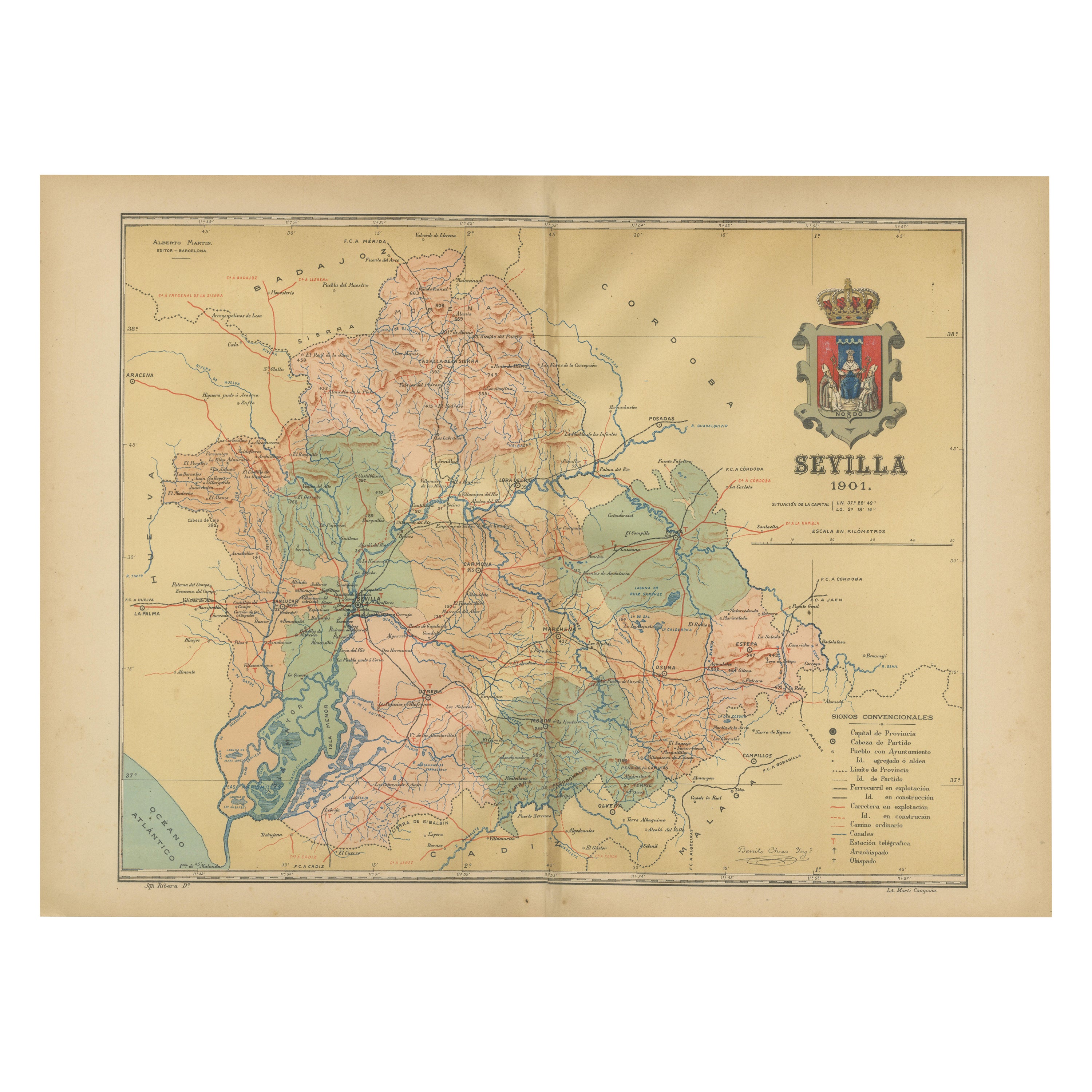
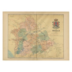
Map of Sevilla Province, 1901: A Depiction of The Spanish Cultural Heartland
Located in Langweer, NL
The print for sale here depicts a historical map of the province of Sevilla (Seville) from the year 1901. Sevilla is located in the southern part of Spain and is part of the autonomo...
Category
Antique Early 1900s Maps
Materials
Paper
$268 Sale Price
30% Off
Free Shipping
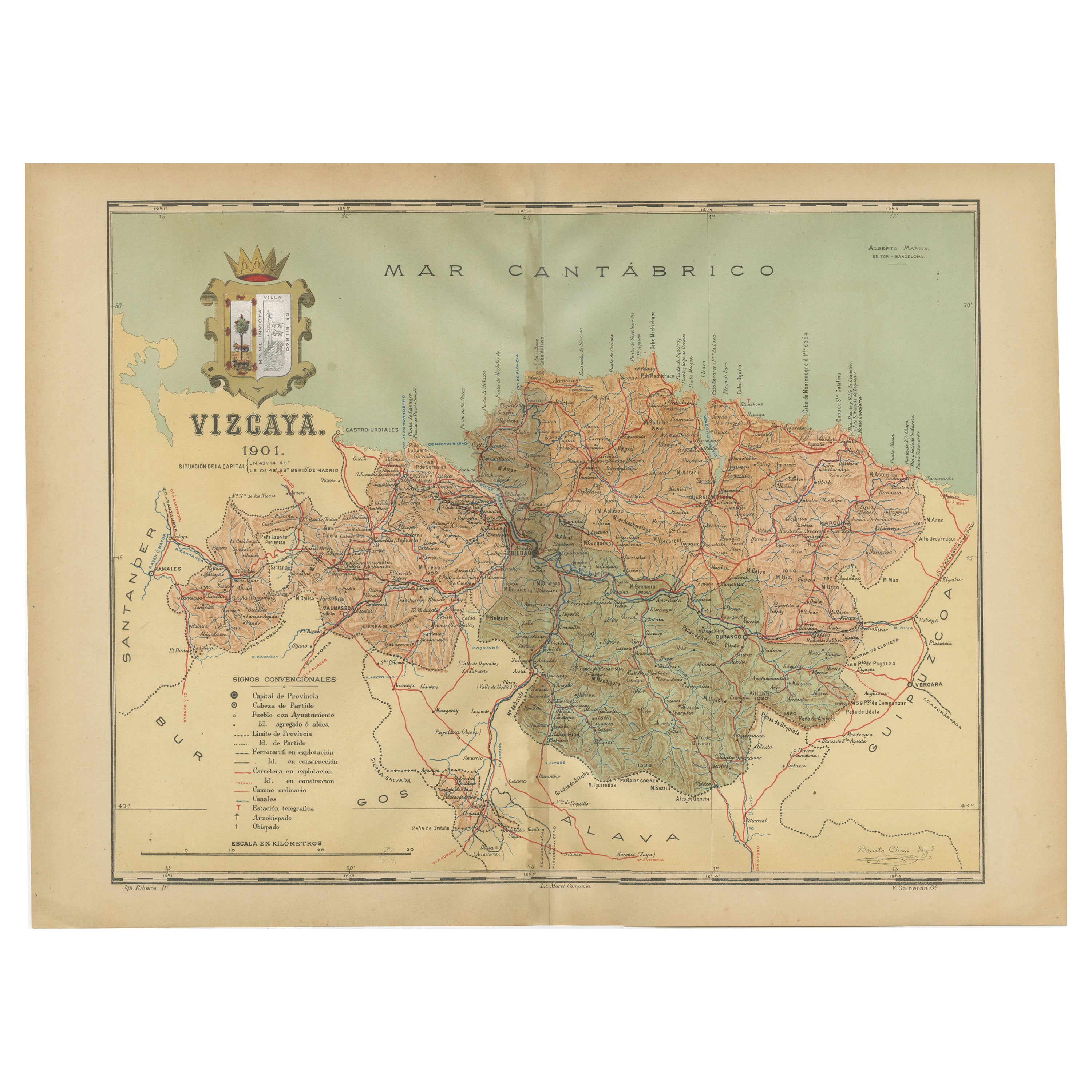
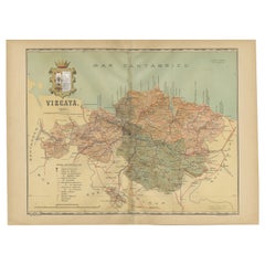
Cartographic Heritage: The 1901 Map of the Vizcaya Province in Spain
Located in Langweer, NL
This is a historical map of the province of Vizcaya (Biscay) in Spain, dated 1901. The title on the map is "VIZCAYA. 1901." It shows the topographical details of the region with cont...
Category
Antique Early 1900s Maps
Materials
Paper
$306 Sale Price
20% Off
Free Shipping
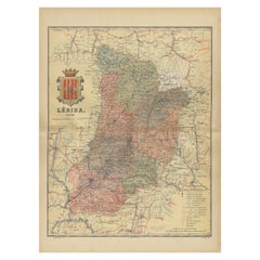
Lleida 1902: A Cartographic Perspective of Catalonia's Gateway to the Pyrenees
Located in Langweer, NL
The map for sale shows the province of Lleida, located in the western part of Catalonia, Spain, as of 1902. Here are the key features depicted on the map:
- **Topography**: The map ...
Category
Antique Early 1900s Maps
Materials
Paper
$287 Sale Price
20% Off
Free Shipping
Topographical and Infrastructure Map of the Province of Valencia, 1901
Located in Langweer, NL
A historical map of the province of Valencia, dated 1901. The map includes intricate details such as topographical features, with mountain ranges and river systems prominently marked...
Category
Antique Early 1900s Maps
Materials
Paper

$498 Sale Price
20% Off
Free Shipping
You May Also Like
Large Original Vintage Map of Spain, circa 1920
Located in St Annes, Lancashire
Great map of Spain
Original color.
Good condition
Published by Alexander Gross
Unframed.
Category
Vintage 1920s English Maps
Materials
Paper

Map of Spain and Portugal - Original Etching - Late 19th Century
Located in Roma, IT
This Map of Spain and Portugal is an etching realized by an anonymous artist.
The state of preservation of the artwork is good with some small diffused stains.
Sheet dimension: 28...
Category
Late 19th Century Modern Figurative Prints
Materials
Etching

1751 Map of Spain Castilla Robert De Vaugondy 1st Edition, Ric.a001
Located in Norton, MA
Large Spain Castilla Robert De Vaugondy
1751 1st Edition
-Colored- Ric.a001
Coming from a family of cartographers, a descendant of the famous Nicolas Sanson and ordinary geographer of the king, Gilles Robert de Vaugondy makes himself known by his maps of the French provinces.
He published an Essay on the History of Geography (1755) from which he excluded the physical geography "too systematic". After a Small Atlas (1748), he draws a universal Atlas (1758), a portable Atlas (1762).
His Atlas of the revolutions of the globe remains unpublished. His warnings and prefaces, his book reviews reveal a Cartesian mind and solid knowledge.
Very early, he associates with his works his son Didier who publishes, since 1742, the methodical tables of Nicolas Sanson, two Globes, one terrestrial, the other celestial (1752).
He is credited with a map of Poland...
Category
Antique 18th Century Unknown Maps
Materials
Paper

Original Antique Map of Spain and Portugal, circa 1790
Located in St Annes, Lancashire
Super map of Spain and Portugal
Copper plate engraving by A. Bell
Published, circa 1790.
Unframed.
Category
Antique 1790s English Other Maps
Materials
Paper

18th Century Hand Colored Map of Spain and Portugal by Visscher
By Nicolaes Visscher II
Located in Alamo, CA
This is an early 18th century map of Spain and Portugal, with attractive original hand-coloring, entitled "Hispaniae et Portugalliae Regna per Nicolaum Visscher cum Privilegio Ordinu...
Category
Antique Early 18th Century Dutch Maps
Materials
Paper

Ancient National Atlas of France with Marengo
Located in Alessandria, Piemonte
Ancient National Atlas of France with the department of Marengo: a rare French etching dated 1806.
ST/178.
Category
Antique Early 19th Century French Other Prints
Materials
Paper

More Ways To Browse
Medieval Castle
Railway Map
Antique Holy Water
Antique Royal Dishes
Mid Century Garden Water Fountain
San Ildefonso
Antique Collectible Pigs
Garden Pig
Water Ski
Gothic Holy Water
Antique Oushak
Mid Century Danish Directors Chairs
Moller 70
Argentina Travel Poster
Century Furniture Faux Bamboo
Early American Chairs
Hans Muller
Vintage Wood Table With Glass Top