Items Similar to Venetian Trade Routes in the Levant – Antique Map by Pieter van der Aa, ca.1720


Want more images or videos?
Request additional images or videos from the seller
1 of 10
Venetian Trade Routes in the Levant – Antique Map by Pieter van der Aa, ca.1720
$372.70
£282.33
€320
CA$516.33
A$579.10
CHF 303.26
MX$7,036.58
NOK 3,850.94
SEK 3,650.96
DKK 2,436.41
About the Item
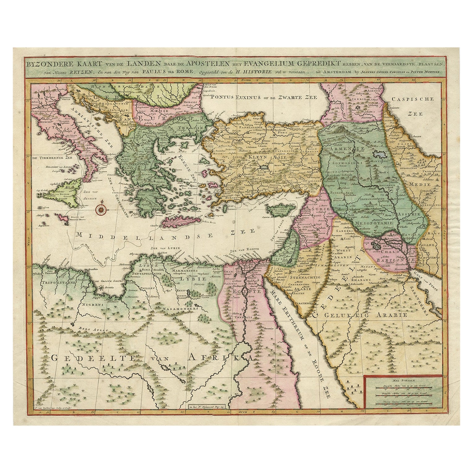
Venetian Trade Routes in the Levant – Antique Map by Pieter van der Aa, Early 18th Century
This finely engraved map, published by Pieter van der Aa in Leiden, provides a detailed depiction of the Eastern Mediterranean, highlighting regions that were central to Venetian trade in the Levant. The map spans from Italy and the Adriatic in the west to Anatolia, the Aegean, and the Levantine coast in the east, covering territories of great commercial and strategic importance during the height of Venetian maritime influence.
One of the most striking features of this map is the decorative cartouche in the upper right corner, illustrating a lively port scene with Venetian merchants and ships engaged in trade. This imagery reinforces the purpose of the map, which was likely intended to document and celebrate Venice's extensive commercial network. The inclusion of ships, waterfront architecture, and merchants actively engaged in business suggests that this map was more than just a geographical reference; it was also a testament to Venice’s dominant role in Mediterranean trade during previous centuries.
The map is labeled in Dutch, with place names carefully engraved to reflect the political and commercial landscape of the early 18th century. Cities such as Constantinople, Alexandria, and Tripoli are prominently featured, emphasizing their importance as trading hubs. The Aegean islands, critical for navigation and maritime commerce, are well-represented with precise detailing. The map includes a scale and compass rose, indicating its utility for navigation or scholarly reference.
The condition of the map is very good for its age, with strong impressions and legible detailing. The paper has developed a natural patina, characteristic of early 18th-century prints. There is some light toning and minor creasing, particularly along the fold lines, which is typical of maps that were originally folded for inclusion in travel books or atlases. There are no major tears or significant losses, preserving the integrity of the engraving. Some minor foxing and handling marks can be observed, but they do not detract from the visual appeal.
For framing, a classic approach would best highlight the map’s historical and artistic qualities. Using an acid-free mount in an off-white or cream tone will complement the aged paper while providing protection. A traditional wooden frame in dark mahogany or gilded gold would enhance the map’s antique character, evoking the elegance of 18th-century European cartography. For added preservation, UV-resistant glass or museum-quality acrylic is recommended to protect against light exposure and environmental factors. Alternatively, float mounting the map with visible deckled edges can create a striking presentation that emphasizes its authenticity and age.
This rare and historically significant map serves as both an elegant decorative piece and a fascinating document of Venetian trade and influence in the Mediterranean. Its fine engraving, detailed cartographic work, and evocative imagery make it a valuable addition to any collection of antique maps or maritime history.This map was published in the early 18th century, likely between 1707 and 1729, by Pieter van der Aa in Leiden. Van der Aa was a prolific Dutch publisher known for his finely engraved maps, often produced for travel books and historical accounts.
Given the map’s subject matter and style, it was likely part of his work Galerie Agréable du Monde (1729) or Les Voyages célèbres et remarquables (1707-1727), both of which contained maps and illustrations related to historical trade routes and exploration. The focus on Venetian trade in the Levant aligns with the themes commonly found in these collections.
- Dimensions:Height: 7.09 in (18 cm)Width: 11.03 in (28 cm)Depth: 0.01 in (0.2 mm)
- Materials and Techniques:Paper,Engraved
- Period:1720-1729
- Date of Manufacture:circa 1720
- Condition:Condition is good for its age, with strong impressions and legible detailing. The paper has developed a natural patina, characteristic of early 18th-century prints. There is some light toning and minor creasing, particularly along the fold lines.
- Seller Location:Langweer, NL
- Reference Number:Seller: BG-139231stDibs: LU3054343906422
About the Seller
5.0
Recognized Seller
These prestigious sellers are industry leaders and represent the highest echelon for item quality and design.
Platinum Seller
Premium sellers with a 4.7+ rating and 24-hour response times
Established in 2009
1stDibs seller since 2017
2,516 sales on 1stDibs
Typical response time: <1 hour
- ShippingRetrieving quote...Shipping from: Langweer, Netherlands
- Return Policy
Authenticity Guarantee
In the unlikely event there’s an issue with an item’s authenticity, contact us within 1 year for a full refund. DetailsMoney-Back Guarantee
If your item is not as described, is damaged in transit, or does not arrive, contact us within 7 days for a full refund. Details24-Hour Cancellation
You have a 24-hour grace period in which to reconsider your purchase, with no questions asked.Vetted Professional Sellers
Our world-class sellers must adhere to strict standards for service and quality, maintaining the integrity of our listings.Price-Match Guarantee
If you find that a seller listed the same item for a lower price elsewhere, we’ll match it.Trusted Global Delivery
Our best-in-class carrier network provides specialized shipping options worldwide, including custom delivery.More From This Seller
View AllAntique Map Eastern Mediterranean by D. Stoopendaal 'circa 1710'
Located in Langweer, NL
Antique map Middle East titled 'De Beschryving van de Reysen Pauli en van de Andere Apostelen'. Antique map of the Eastern Mediterranean with details of the travels by Apostle Paul...
Category
Antique Early 18th Century Dutch Maps
Materials
Paper

$326 Sale Price
20% Off
Antique Map of Eastern Mediterranean and Asia Minor by a Benedictine, c.1725
Located in Langweer, NL
Antique map titled 'Byzondere Afbeelding der Landschappen, van de Apostelen bevaren en doorwandelt om het Evangelium J. C. te Prediken.' Map of the lands travelled by the Apostles to...
Category
Antique 18th Century Maps
Materials
Paper

$279 Sale Price
20% Off
Antique Map of the Eastern Mediterranean, C.1710
Located in Langweer, NL
Antique map Middle East titled 'De Beschryving van de Reysen Pauli en van de Andere Apostelen'. Antique map of the Eastern Mediterranean with det...
Category
Antique 18th Century Maps
Materials
Paper

Antique Map of the Holy Land Described in the Old and New Testament, ca.1660
Located in Langweer, NL
Antique map titled 'Geographiae Sacrae ex Veteri et Novo Testamento Desumptae Tabula Prima quae Totius Orbis Partes Continet.'
Map of the lands described in the Old and New Testame...
Category
Antique 1660s Maps
Materials
Paper

$791 Sale Price
20% Off
Original Antique Map of Syria Phoenice by Van Dùren '1749'
Located in Langweer, NL
Interesting Antique map published in Germany titled 'Neue Vorstellung von Phoenice und Syrien (..)' This map is engraved with a lot of details. It is an original antique map of Syria...
Category
Antique Mid-18th Century Maps
Materials
Paper

$279 Sale Price
20% Off
Highly Decorative Map of The Eastern Mediterranean and The Middle East, ca.1700
Located in Langweer, NL
Antique map titled 'Byzondere Kaart van de Landen Daar de Apostelen Het Evangelium Gepredikt Hebben (..).'
Highly decorative map of the eastern Mediterranean...
Category
Antique Early 1700s Maps
Materials
Paper
$885 Sale Price
20% Off
Free Shipping
You May Also Like
Southern Greece: A Large 17th C. Hand-colored Map by Sanson and Jaillot
By Nicolas Sanson
Located in Alamo, CA
This large original hand-colored copperplate engraved map of southern Greece and the Pelopponese Peninsula entitled "La Moree Et Les Isles De Zante, Cefalonie, Ste. Marie, Cerigo & C...
Category
Antique 1690s French Maps
Materials
Paper

Greece, "Graeciae Antiquae"" A 17th Century Hand-colored Map by Sanson
By Nicolas Sanson
Located in Alamo, CA
This is an original 17th century hand colored copperplate engraved map of Greece entitled "Graeciae Antiquae Tabula Hanc Geographicam" by Nicolas d'Abbeville Sanson, engraved and pub...
Category
Antique Mid-17th Century French Maps
Materials
Paper

Southern & Eastern Europe: A Large 17th C. Hand-colored Map by Sanson & Jaillot
By Nicolas Sanson
Located in Alamo, CA
This large hand-colored map entitled "Estats de L'Empire des Turqs en Europe, ou sont les Beglerbeglicz our Gouvernements" was originally created by Nicholas Sanson d'Abbeville and t...
Category
Antique 1690s French Maps
Materials
Paper

18th Century Map of the Southern Balkans by Giovanni Maria Cassini
By Giovanni Maria Cassini
Located in Hamilton, Ontario
18th century map by Italian engraver Giovanni Maria Cassini (Italy 1745-1824).
Map of the Southern Balkans: Rome. Hand colored and copper engraved print done in the year 1788. It in...
Category
Antique 18th Century Italian Maps
Materials
Paper

$795 Sale Price
36% Off
Mediterranean and Adriatic Seas: Original 18th Century Hand-colored Map by Bowen
Located in Alamo, CA
This is an original 18th century hand-colored map entitled "An Accurate Chart of The Mediterranean and Adriatic Sea's; with the Archipelago & Part of the Black Sea. Exhibiting all th...
Category
Mid-18th Century Old Masters Landscape Prints
Materials
Engraving

1718 Ides & Witsen Map "Route D'amsterdam a Moscow Et De La Ispahan Et Gamron
Located in Norton, MA
1718 Ides & Witsen map, entitled
"Route D'Amsterdam A Moscow Et De La Ispahan Et Gamron,"
Ric.b005
Subject: Eastern Europe and Central Asia
Period: 1718 (published)
Publicati...
Category
Antique Early 18th Century Dutch Maps
Materials
Paper

More Ways To Browse
Wooden Compass
Antique Gold Compass
Compass Rose Gold
Antique Wooden Compass
Vintage Scandanavian Chairs
19th Century Red Glass
Antique French Console Table Tables
Silver Bowl Large
Antique French Silk
Down Couch
Used Lighter Art
Blue Edge Glass
Mahogany 1950s Furniture
Solid Mahogany Table
Dessert Glasses
Geometric Glass Table
Mid Century Pin
6x10 Rug