Items Similar to Zaragoza: Crossroads of Heritage - The 1901 Cartographic Chronicle


Want more images or videos?
Request additional images or videos from the seller
1 of 7
Zaragoza: Crossroads of Heritage - The 1901 Cartographic Chronicle
$302.45
$378.0620% Off
£226.71
£283.3820% Off
€256
€32020% Off
CA$415.52
CA$519.4020% Off
A$463.89
A$579.8620% Off
CHF 243.07
CHF 303.8420% Off
MX$5,678.42
MX$7,098.0320% Off
NOK 3,086.98
NOK 3,858.7320% Off
SEK 2,910.63
SEK 3,638.2920% Off
DKK 1,948.77
DKK 2,435.9620% Off
About the Item
The print on sale is a historical map of the province of Zaragoza, Spain, dated 1901. The title on the map is "ZARAGOZA. 1901." This map details the geographical features of Zaragoza with contour lines and color gradations to indicate elevation, as well as highlighting rivers, roads, and rail networks. The provincial capital, Zaragoza city, is prominently marked. Symbols used on the map include those for provincial capitals, towns, churches, ruins, lighthouses, and more, with a legend ("Signos Convencionales") explaining these symbols.
Zaragoza is known for:
1. **Basilica of Our Lady of the Pillar**: One of the most famous Marian sanctuaries in the Catholic world, which according to tradition, was visited by the Virgin Mary.
2. **Mudejar Architecture**: Zaragoza has numerous examples of Mudejar architecture, a style that is a blend of Christian and Moorish design, and is a UNESCO World Heritage Site.
3. **Fiestas del Pilar**: A major festival in honor of the Virgin del Pilar, featuring religious processions, concerts, and exhibitions.
4. **Location**: It is situated on the banks of the Ebro River and has historically been a crossroads between Madrid, Barcelona, Valencia, and Bilbao.
5. **Gastronomy**: The region's cuisine is known for its variety and richness, influenced by the Ebro Valley and Aragonese culinary traditions.
6. **La Lonja**: A Renaissance building of significant historical importance in the city, used for commercial exchanges during the 16th century.
7. **Roman Heritage**: Zaragoza was founded as the Roman city of Caesaraugusta, and remnants of its Roman walls and forum can still be seen.
8. **The Palace of Aljafería**: An 11th-century Moorish castle, which later became the residence of the Kings of Aragon, and is now home to the Aragonese parliament.
- Dimensions:Height: 14.77 in (37.5 cm)Width: 20.08 in (51 cm)Depth: 0 in (0.02 mm)
- Materials and Techniques:
- Period:1900-1909
- Date of Manufacture:1901
- Condition:Good condition. Central vertical folding lines as issued. Aged paper with typically warm, yellowish-brown hue, especially around the edges and folding lines, adding to its patina. Check the images carefully.
- Seller Location:Langweer, NL
- Reference Number:Seller: BG-13642-471stDibs: LU3054338034002
About the Seller
5.0
Recognized Seller
These prestigious sellers are industry leaders and represent the highest echelon for item quality and design.
Platinum Seller
Premium sellers with a 4.7+ rating and 24-hour response times
Established in 2009
1stDibs seller since 2017
2,513 sales on 1stDibs
Typical response time: <1 hour
- ShippingRetrieving quote...Shipping from: Langweer, Netherlands
- Return Policy
Authenticity Guarantee
In the unlikely event there’s an issue with an item’s authenticity, contact us within 1 year for a full refund. DetailsMoney-Back Guarantee
If your item is not as described, is damaged in transit, or does not arrive, contact us within 7 days for a full refund. Details24-Hour Cancellation
You have a 24-hour grace period in which to reconsider your purchase, with no questions asked.Vetted Professional Sellers
Our world-class sellers must adhere to strict standards for service and quality, maintaining the integrity of our listings.Price-Match Guarantee
If you find that a seller listed the same item for a lower price elsewhere, we’ll match it.Trusted Global Delivery
Our best-in-class carrier network provides specialized shipping options worldwide, including custom delivery.More From This Seller
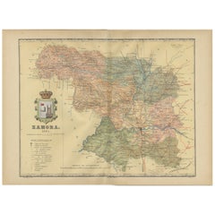
View AllZamora: A Mosaic of Romanesque Heritage and Natural Wonders in Spain, 1901
Located in Langweer, NL
This authentic antique print is a historical map of the province of Zamora, Spain, from the year 1901. The title on the map is "ZAMORA. 1901." As with the previous map, it displays t...
Category
Antique Early 1900s Maps
Materials
Paper
$302 Sale Price
20% Off
Free Shipping
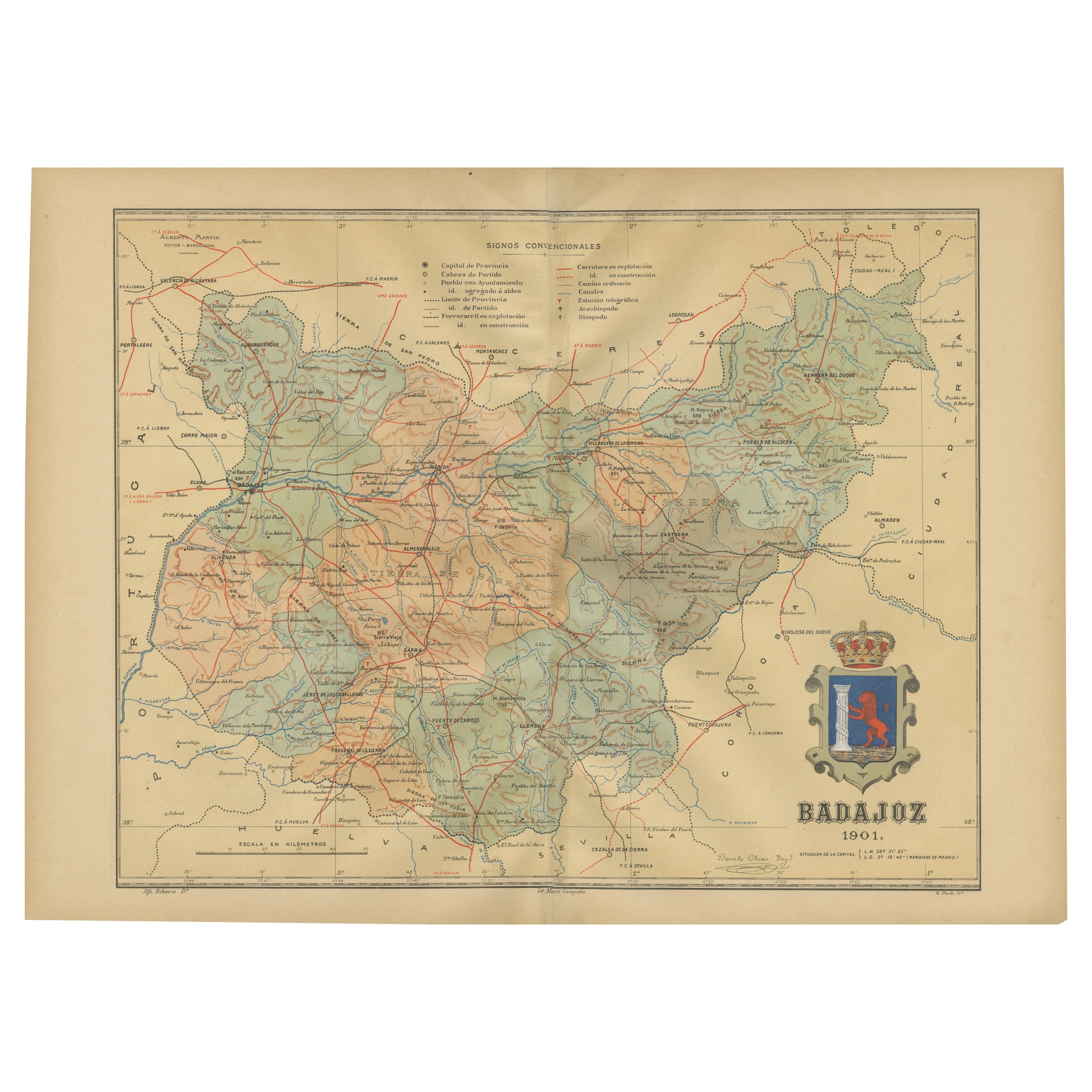
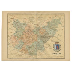
Badajoz 1901: A Cartographic Record of Extremadura's Largest Province in Spain
Located in Langweer, NL
This original antique map for sale is of the province of Badajoz, part of the autonomous community of Extremadura in Spain, dated 1901. It illustrates several important features:
Th...
Category
Antique Early 1900s Maps
Materials
Paper
$293 Sale Price
20% Off
Free Shipping
Navarra in Cartographic Detail: A 1902 Map of the Crossroads of Northern Spain
Located in Langweer, NL
The original antique map for sale shows the Spanish province of Navarra as it was in 1902. Here's a brief description and a potential title for the map:
Description:
- The map detai...
Category
Antique Early 1900s Maps
Materials
Paper

$321 Sale Price
20% Off
Free Shipping
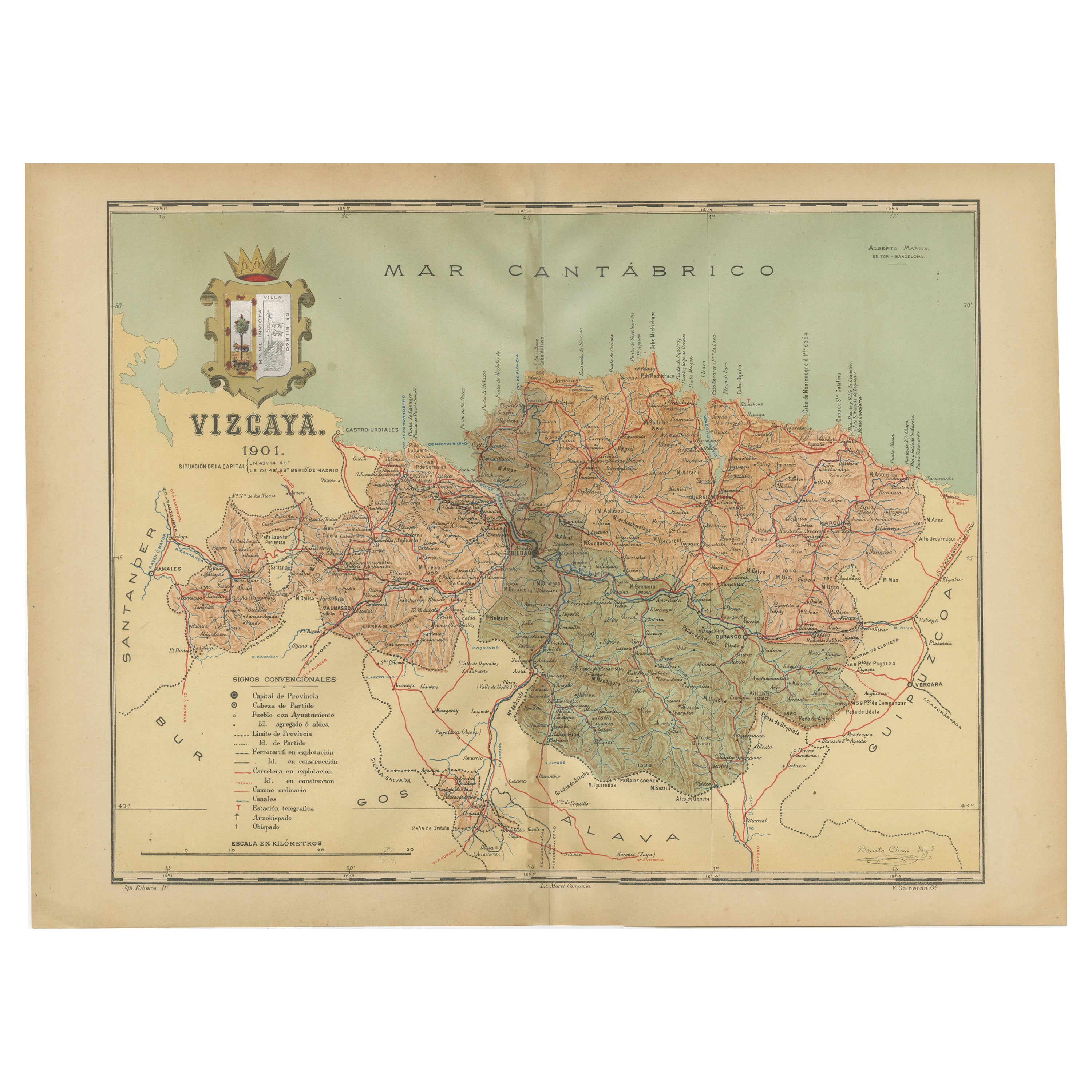
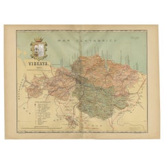
Cartographic Heritage: The 1901 Map of the Vizcaya Province in Spain
Located in Langweer, NL
This is a historical map of the province of Vizcaya (Biscay) in Spain, dated 1901. The title on the map is "VIZCAYA. 1901." It shows the topographical details of the region with cont...
Category
Antique Early 1900s Maps
Materials
Paper
$302 Sale Price
20% Off
Free Shipping
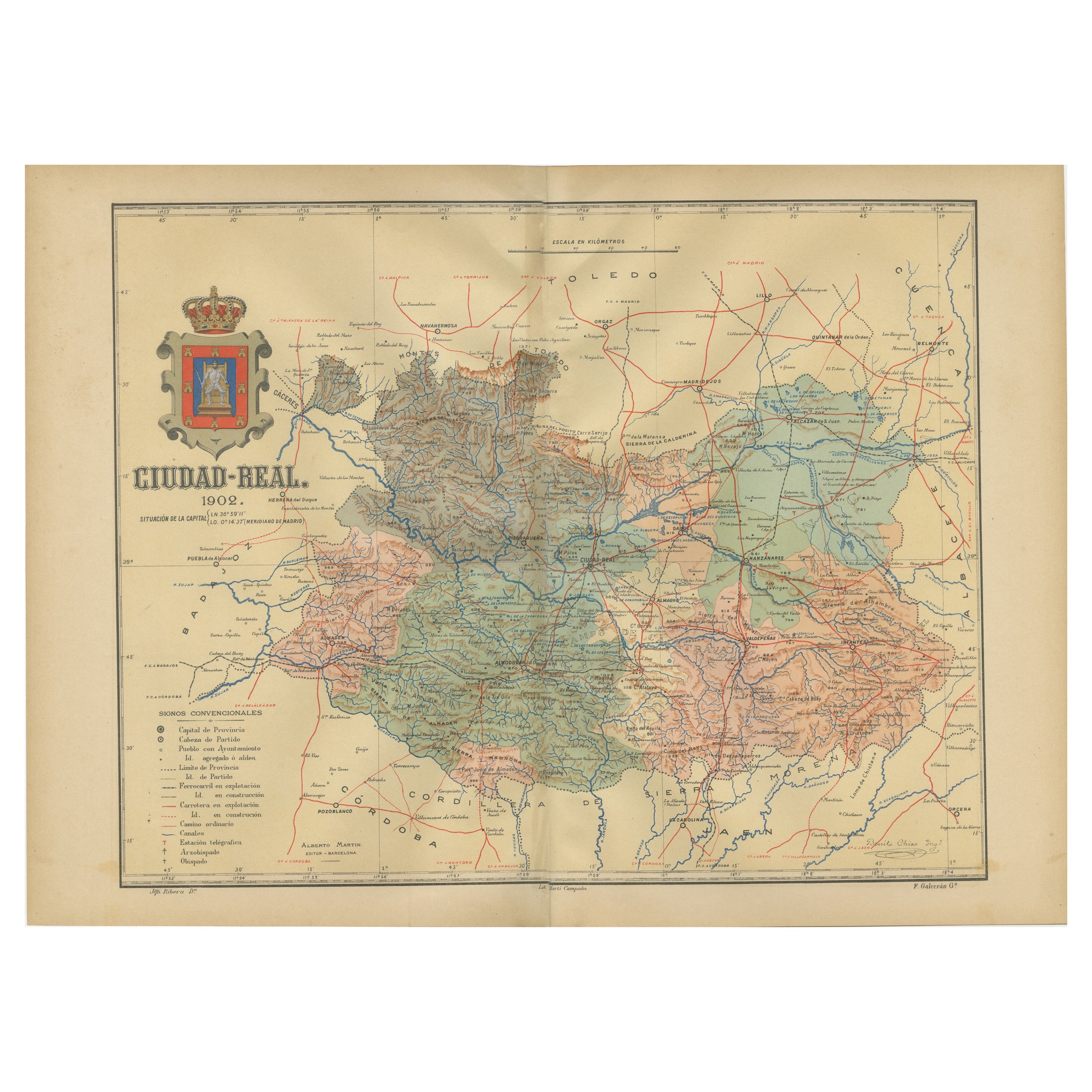
Ciudad Real 1902: A Detailed Cartographic Survey of La Mancha in Spain
Located in Langweer, NL
This original antitque map presents the province of Ciudad Real, located in the autonomous community of Castilla-La Mancha in central Spain, as of 1902. It includes several notable f...
Category
Antique Early 1900s Maps
Materials
Paper

$321 Sale Price
20% Off
Free Shipping
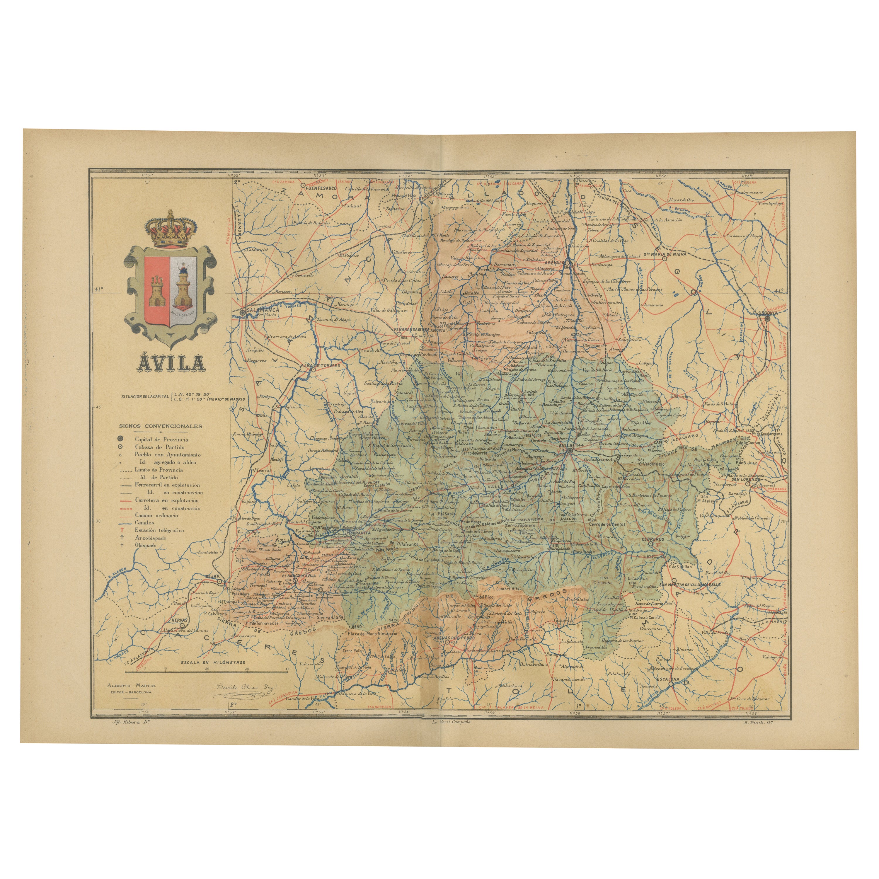
Ávila in a Historical Map of 1902: A Geographic and Administrative Overview
Located in Langweer, NL
The map is of the province of Ávila, one of the provinces of the autonomous community of Castile and León in Spain, and it is dated from 1902. The map illustrates several geographic ...
Category
Antique Early 1900s Maps
Materials
Paper

$274 Sale Price
20% Off
Free Shipping
You May Also Like
Large Original Vintage Map of Spain, circa 1920
Located in St Annes, Lancashire
Great map of Spain
Original color.
Good condition
Published by Alexander Gross
Unframed.
Category
Vintage 1920s English Maps
Materials
Paper

Original 1891 Walker Map
Located in Norwell, MA
Original 1891 map of Massachusetts by Walker. Towns include Cambridge, Boston, Dedham, Ashland, Brookline, Newton etc... burl wood frame. Measures...
Category
Antique 19th Century Maps

Original Antique Map of the American State of Colorado, 1903
Located in St Annes, Lancashire
Antique map of Colorado
Published By A & C Black. 1903
Original colour
Good condition
Unframed.
Free shipping
Category
Antique Early 1900s English Maps
Materials
Paper

South America, Eastern Part. Century Atlas antique vintage map
Located in Melbourne, Victoria
'The Century Atlas. South America. Eastern Part'
Original antique map, 1903.
Inset map 'Rio de Janeiro and Vicinity'.
Central fold as issued. Map name and number printed on the rev...
Category
Early 20th Century Victorian More Prints
Materials
Lithograph

South America, North-West Part. Century Atlas antique vintage map
Located in Melbourne, Victoria
'The Century Atlas. South America, North-West Part'
Original antique map, 1903.
Central fold as issued. Map name and number printed on the reverse corners.
Sheet 40cm by 29.5cm.
Category
Early 20th Century Victorian More Prints
Materials
Lithograph

Original Antique Map of the American State of Arizona & New Mexico, 1903
Located in St Annes, Lancashire
Antique map of Arizona and New Mexico
Published By A & C Black. 1903
Original colour
Good condition
Unframed.
Free shipping
Category
Antique Early 1900s English Maps
Materials
Paper

More Ways To Browse
11th Century
Roman Pillar
Antique Forum
Spanish Mudejar
Early American Chairs
Hans Muller
Vintage Wood Table With Glass Top
19th Century Square Table
Antonio Bonet
Galle Chairs
Large Chinese Rug
1940s Vintage French Art Deco
20th Century Spanish Table
Antonio Bellini
Retro Fiberglass Furniture
Shipping Crate
Antique Oushak Carpets
Blue Coffee Tables