Items Similar to Antique Plan of the Residence of the Mayor of Amsterdam by H. de Leth circa 1732
Want more images or videos?
Request additional images or videos from the seller
1 of 5
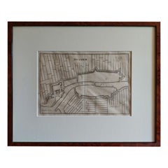
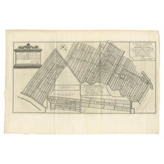
Antique Plan of the Residence of the Mayor of Amsterdam by H. de Leth circa 1732
$452.85
$566.0720% Off
£338.97
£423.7220% Off
€384
€48020% Off
CA$623.26
CA$779.0720% Off
A$694.68
A$868.3620% Off
CHF 364.48
CHF 455.6020% Off
MX$8,483.23
MX$10,604.0420% Off
NOK 4,615.07
NOK 5,768.8420% Off
SEK 4,361.94
SEK 5,452.4320% Off
DKK 2,923.28
DKK 3,654.1020% Off
About the Item
Antique print titled 'Plattegrond van de Hofstede en het huis te Spyk. Behorende de Edelen van Grootambacht. Heere en Mr. Ian van de Poll Burgermeester der stad Amsterdam'. Rare plan of the Residence of the Mayor of Amsterdam (the Netherlands). Dutch and French text in cartouche.
- Dimensions:Height: 18.63 in (47.3 cm)Width: 19.1 in (48.5 cm)Depth: 0.79 in (2 cm)
- Materials and Techniques:
- Period:
- Date of Manufacture:1732
- Condition:Great condition, unique frame included. Please study image carefully.
- Seller Location:Langweer, NL
- Reference Number:1stDibs: LU3054310287603
About the Seller
5.0
Recognized Seller
These prestigious sellers are industry leaders and represent the highest echelon for item quality and design.
Platinum Seller
Premium sellers with a 4.7+ rating and 24-hour response times
Established in 2009
1stDibs seller since 2017
2,517 sales on 1stDibs
Typical response time: <1 hour
- ShippingRetrieving quote...Shipping from: Langweer, Netherlands
- Return Policy
Authenticity Guarantee
In the unlikely event there’s an issue with an item’s authenticity, contact us within 1 year for a full refund. DetailsMoney-Back Guarantee
If your item is not as described, is damaged in transit, or does not arrive, contact us within 7 days for a full refund. Details24-Hour Cancellation
You have a 24-hour grace period in which to reconsider your purchase, with no questions asked.Vetted Professional Sellers
Our world-class sellers must adhere to strict standards for service and quality, maintaining the integrity of our listings.Price-Match Guarantee
If you find that a seller listed the same item for a lower price elsewhere, we’ll match it.Trusted Global Delivery
Our best-in-class carrier network provides specialized shipping options worldwide, including custom delivery.More From This Seller
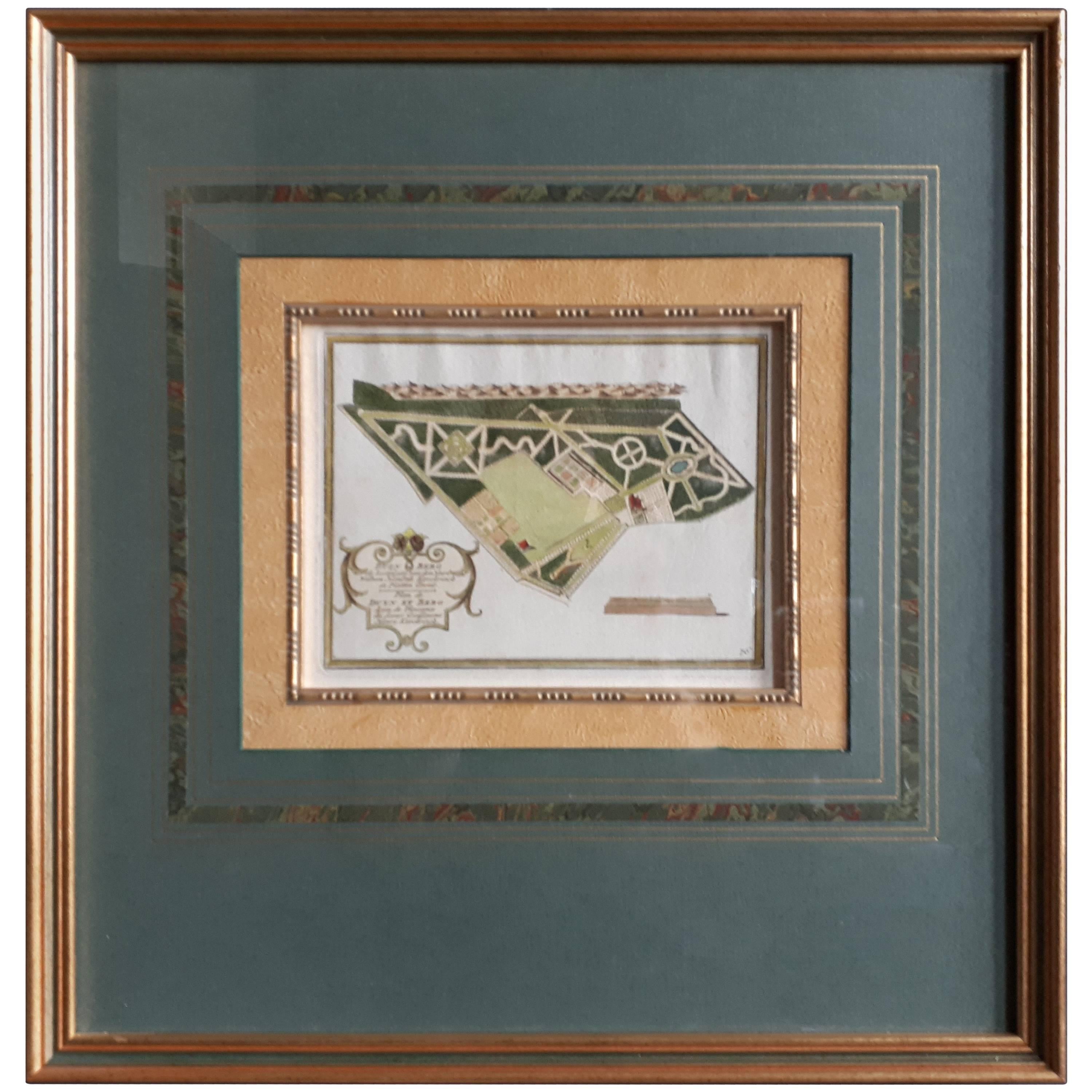
View AllAntique Plan of Duin en Berg 'the Netherlands' by H. de Leth circa 1732
Located in Langweer, NL
Antique plan titled 'Beschrijving Duin en Berg, de Lustplaets van den Heere Wilhem Hendrik Kerckrinck in Platten Gront'. Decorative cartouche with Dutch and French text. This plan or...
Category
Antique Mid-18th Century Prints
Materials
Paper
$452 Sale Price
20% Off
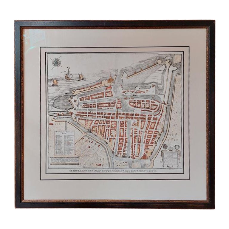
Antique City Plan of Rotterdam in Frame, ca.1850
Located in Langweer, NL
Antique map titled 'Grondkaart der stad Rotterdam (..)'. Original antique city plan of Rotterdam, the Netherlands. Published circa 1850.
Artists...
Category
Antique 19th Century Prints
Materials
Paper

$613 Sale Price
20% Off
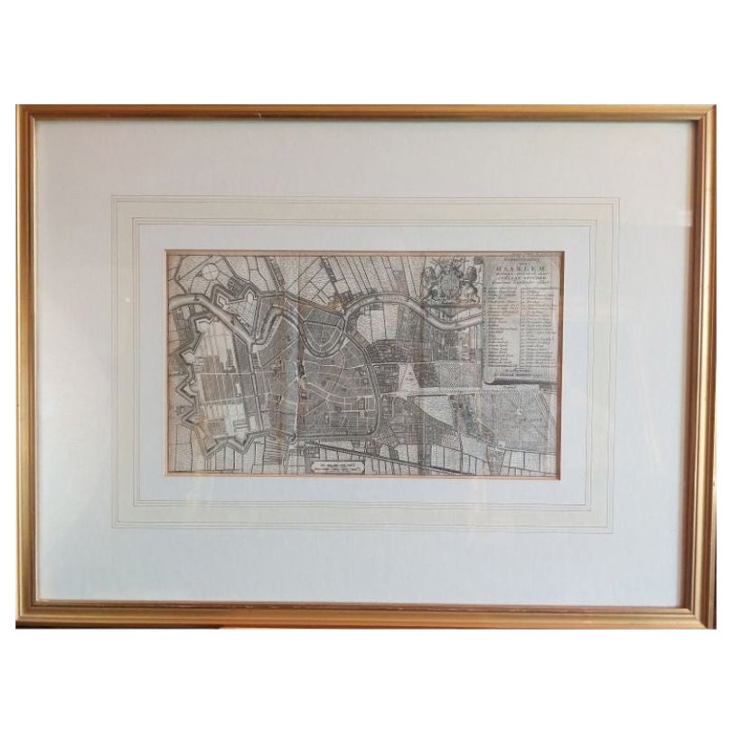
Antique Map of the City of Haarlem by Tirion, 1742
By Isaak Tirion
Located in Langweer, NL
Antique map titled 'Grondtekening van Haarlem (..)'. Original antique map of the city of Haarlem, the Netherlands. Published by I. Tirion, 1742.
Artists and Engravers: Isaak Tirio...
Category
Antique 18th Century Maps
Materials
Paper
$207 Sale Price
20% Off
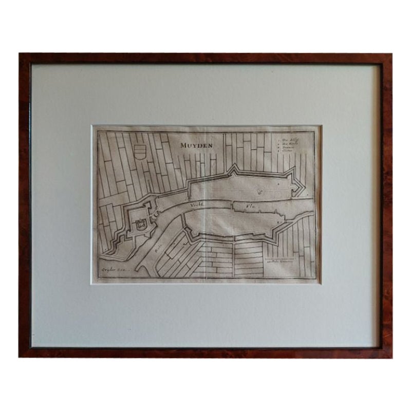
Antique Map of the City of Muiden by Merian, 1659
Located in Langweer, NL
Antique map titled 'Muyden'. Original antique map of the city of Muiden, the Netherlands. This map originates from 'Topographia Germania Inferioris' by C. Merian. Published 1659.
...
Category
Antique 17th Century Maps
Materials
Paper
$146 Sale Price
20% Off
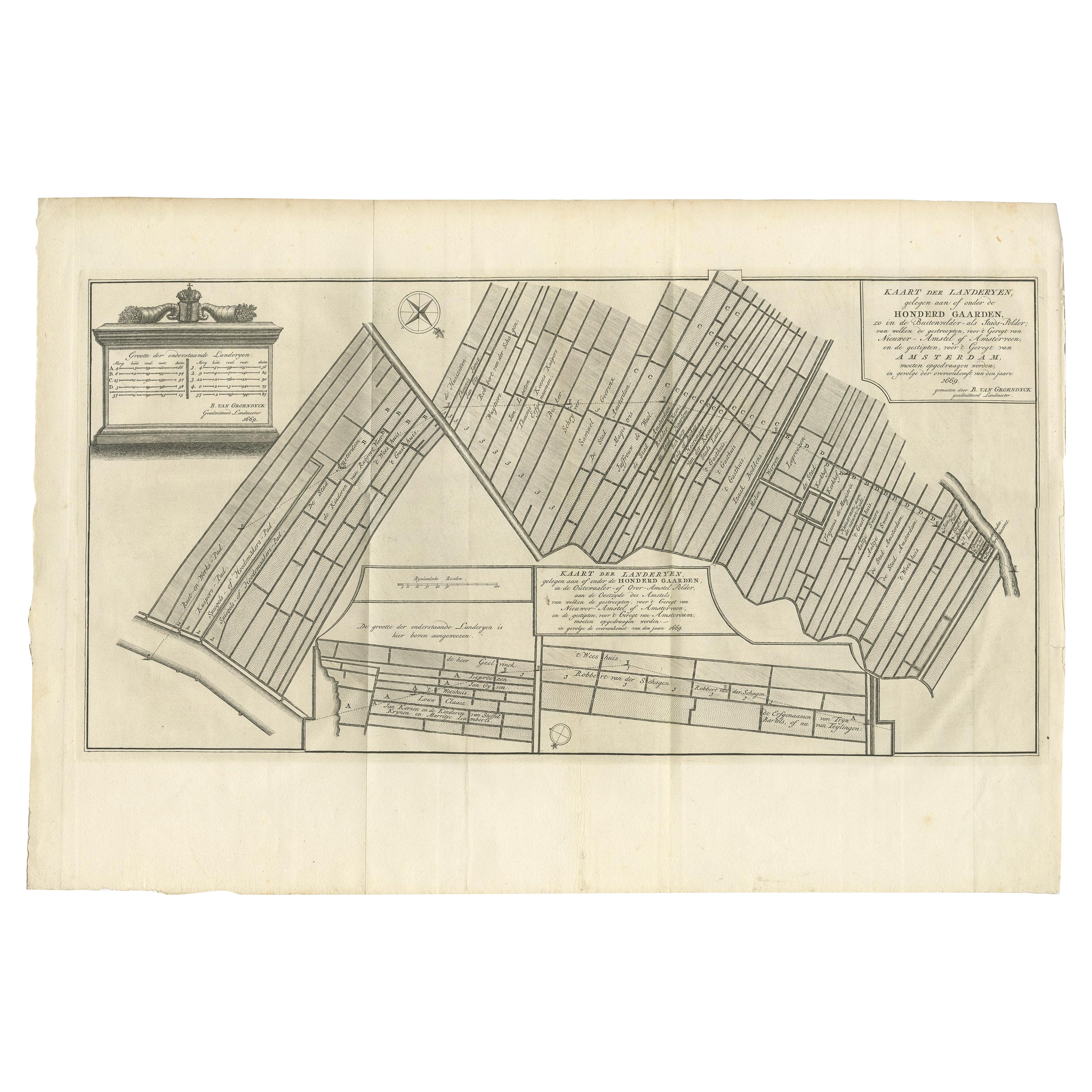
Antique Map Showing Estates of 1669 in Amsterdam, Published in c.1767
Located in Langweer, NL
Antique map titled 'Kaart der landeryen, gelegen aan of onder de honderd gaarden, zo in de Buitenvelder- als Stads-polder; van welken de gestreepten, voor 't geregt van Nieuwer-Amste...
Category
Antique 18th Century Maps
Materials
Paper
$235 Sale Price
20% Off
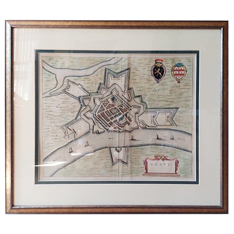
Antique Map of the City of Grave by Blaeu, 1649
Located in Langweer, NL
Antique map titled 'Grave'. Original antique map of the city of Grave, the Netherlands. Published by J. Blaeu, 1649.
Artists and Engravers: Joan Blaeu (23 September 1596 - 28 May...
Category
Antique 17th Century Maps
Materials
Paper

$660 Sale Price
20% Off
You May Also Like
Mid-18th Century Hand Drawn English Farm Map on Vellum, circa 1740s
Located in San Francisco, CA
Mid-18th century hand drawn English farm map on Vellum circa 1740s
Henry Maxted & Isaac Terry, Surveyors.
A Map of a Farm in the Parish of Blean in the County of KENT: Belonging to Mrs Elizabeth Hodgson circa 1743.
A beautiful hand drawn map...
Category
Antique Mid-18th Century English Maps
Materials
Lambskin

Plan of Paris, France, by A. Vuillemin, Antique Map, 1845
Located in Colorado Springs, CO
This large and detailed plan of Paris was published by Alexandre Vuillemin in 1845. The map conveys a wonderful amount of information and is decorated throughout with pictorial vigne...
Category
Antique 1840s American Maps
Materials
Paper

Engraving of the medal and decoration of the Sea Battle of Doggersbank 1781
Located in UTRECHT, UT
Engraving of the commemorative medal and decoration of the Sea Battle of Doggersbank 1781, by Noach van der Meer
After an earlier print by Jacobus Buys.
Published in Beschrijving...
Category
Antique 1780s Dutch Drawings
Materials
Paper
Mid-20th Century Maison Jansen Original Architectural Drawing
Located in New York, NY
An original Maison Jansen pencil drawing depicting an architectural detail "Petit Panneau Directoire" page 70 Stamped: Jansen, 9 Rue Royale Paris 8e
Category
Mid-20th Century French Drawings
Materials
Paper
Antique Town Plan Map, Poole, English, Framed Cartography, Georgian, Circa 1780
Located in Hele, Devon, GB
This is an antique town plan map of Poole in Dorset. An English, framed atlas engraving, dating to the 18th century and later.
Fascinating cartography with annotated streets and pl...
Category
Antique Late 18th Century British George III Maps
Materials
Glass, Wood, Paper

Framed 1731 Color Engraving, Map of Rotterdam by Matthaus Seutter, "Roterodami"
Located in Bridgeport, CT
"Roterodami". Seutter (1678-1757) was an important German 18th century map maker. Bird's eye view of the city above with full details, neoclassi...
Category
Antique 18th Century European Renaissance Maps
Materials
Glass, Wood, Paper

More Ways To Browse
Hand Colored Engraving
Gold Fox
Japanese Wall Plate
Indonesian House
Hunting Engravings
Mid Century Serigraph
Military Hat
Gould Bird
Indonesia Jakarta
Knights Armour
Fruit Botanicals
Large Wall Maps
Knight In Armour
Hand Colored Copper Engraving
Antique Catholic Prints
Medieval Armour
Medieval Knight
Medieval Plate