Items Similar to Antique Plan of Duin en Berg 'the Netherlands' by H. de Leth circa 1732
Want more images or videos?
Request additional images or videos from the seller
1 of 5
Antique Plan of Duin en Berg 'the Netherlands' by H. de Leth circa 1732
About the Item
Antique plan titled 'Beschrijving Duin en Berg, de Lustplaets van den Heere Wilhem Hendrik Kerckrinck in Platten Gront'. Decorative cartouche with Dutch and French text. This plan originates from 'Het zegepralent Kennemerland', by H. de Leth and M. Brouerius van Nidek, Amsterdam, circa 1732.
- Dimensions:Height: 18.9 in (48 cm)Width: 18.12 in (46 cm)Depth: 0.79 in (2 cm)
- Materials and Techniques:
- Period:
- Date of Manufacture:1732
- Condition:Great condition, unusual frame included. Please study image carefully.
- Seller Location:Langweer, NL
- Reference Number:1stDibs: LU3054310287713
About the Seller
5.0
Platinum Seller
These expertly vetted sellers are 1stDibs' most experienced sellers and are rated highest by our customers.
Established in 2009
1stDibs seller since 2017
1,933 sales on 1stDibs
Typical response time: <1 hour
- ShippingRetrieving quote...Ships From: Langweer, Netherlands
- Return PolicyA return for this item may be initiated within 14 days of delivery.
More From This SellerView All
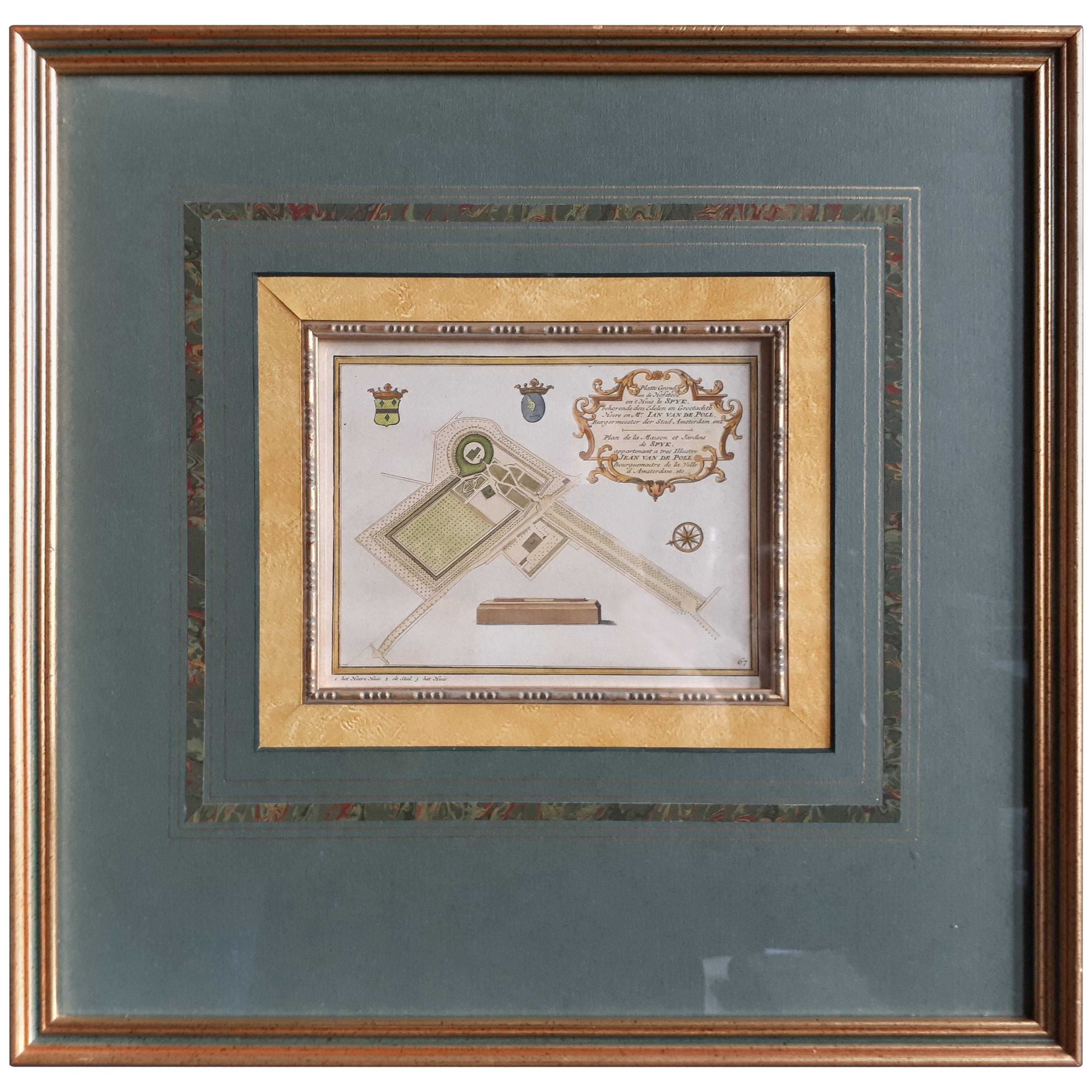
- Antique Plan of the Residence of the Mayor of Amsterdam by H. de Leth circa 1732Located in Langweer, NLAntique print titled 'Plattegrond van de Hofstede en het huis te Spyk. Behorende de Edelen van Grootambacht. Heere en Mr. Ian van de Poll Burgermeester der stad Amsterdam'. Rare plan...Category
Antique Mid-18th Century Prints
MaterialsPaper
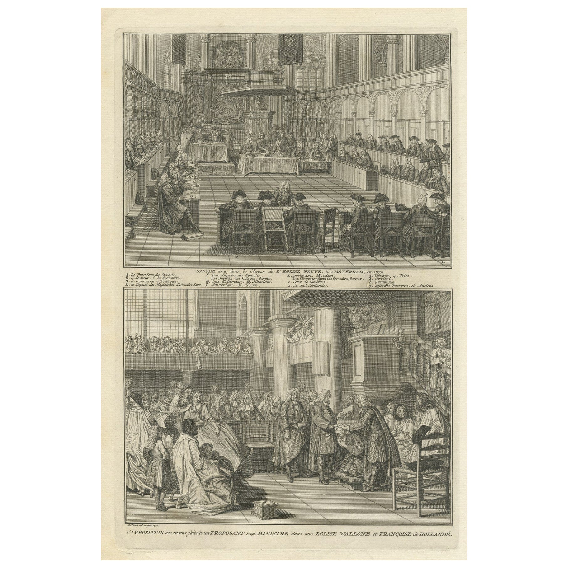
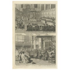
- Engraving of a Meeting of the Dutch Synode in Amsterdam, The Netherlands, 1732Located in Langweer, NLAntique print titled 'Synode tenu dans le Choeur (..)'. Old print of a meeting of the Dutch Synode in 'De Nieuwe Kerk' in Amsterdam, The Netherlands in 1730. Also depicted the accept...Category
Antique 18th Century Prints
MaterialsPaper
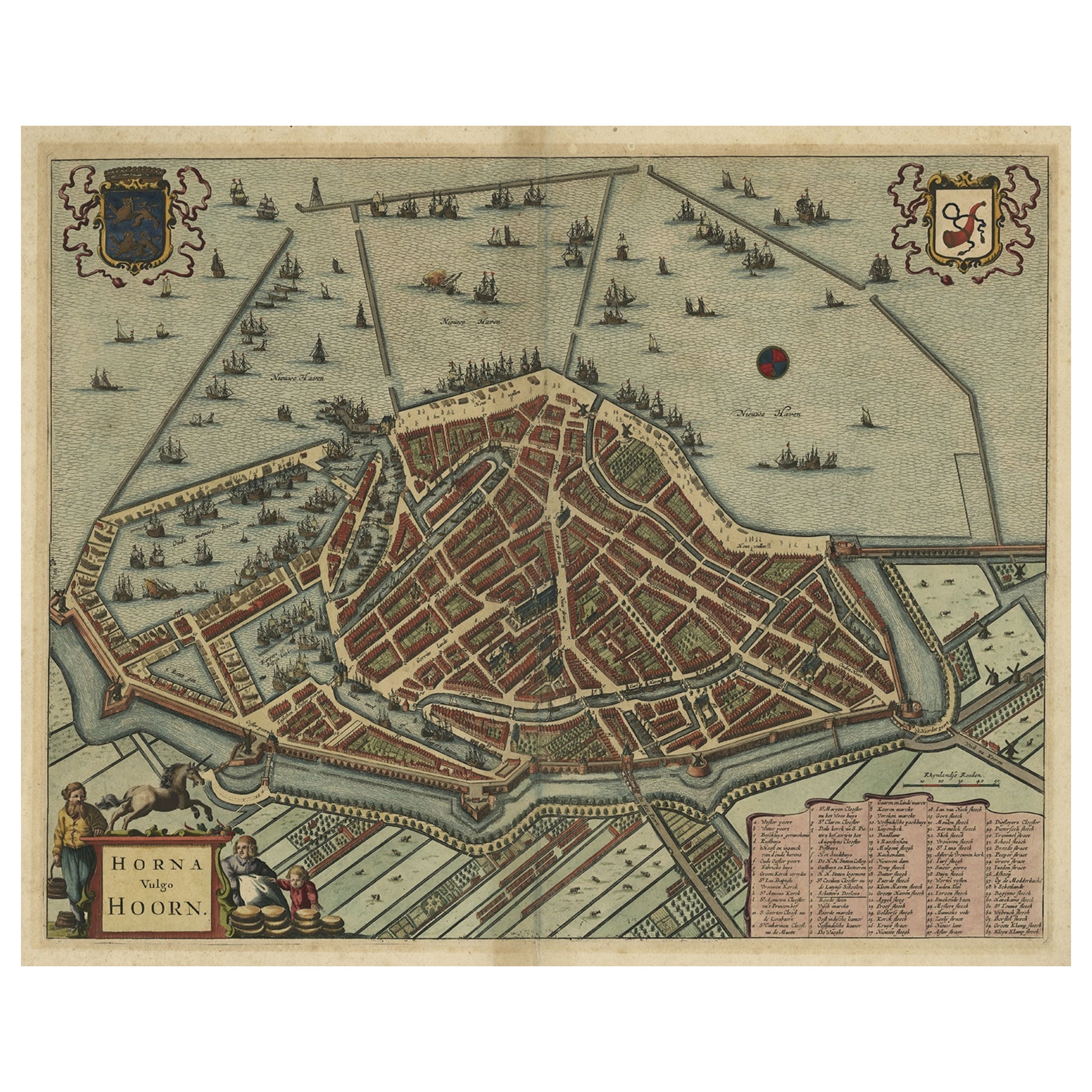
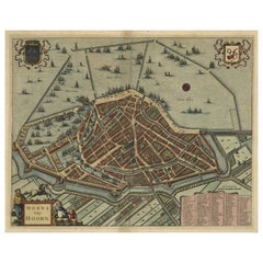
- Original Antique Bird's Eye View Plan of Hoorn, The Netherlands by Blaeu, c.1700Located in Langweer, NLAntique map titled 'Horna vulgo Hoorn'. Bird's eye view plan of Hoorn, The Netherlands. With title cartouche, coats of arms and key. From an atlas published by De Wit, ca. 1698-1...Category
Antique Early 1700s Maps
MaterialsPaper
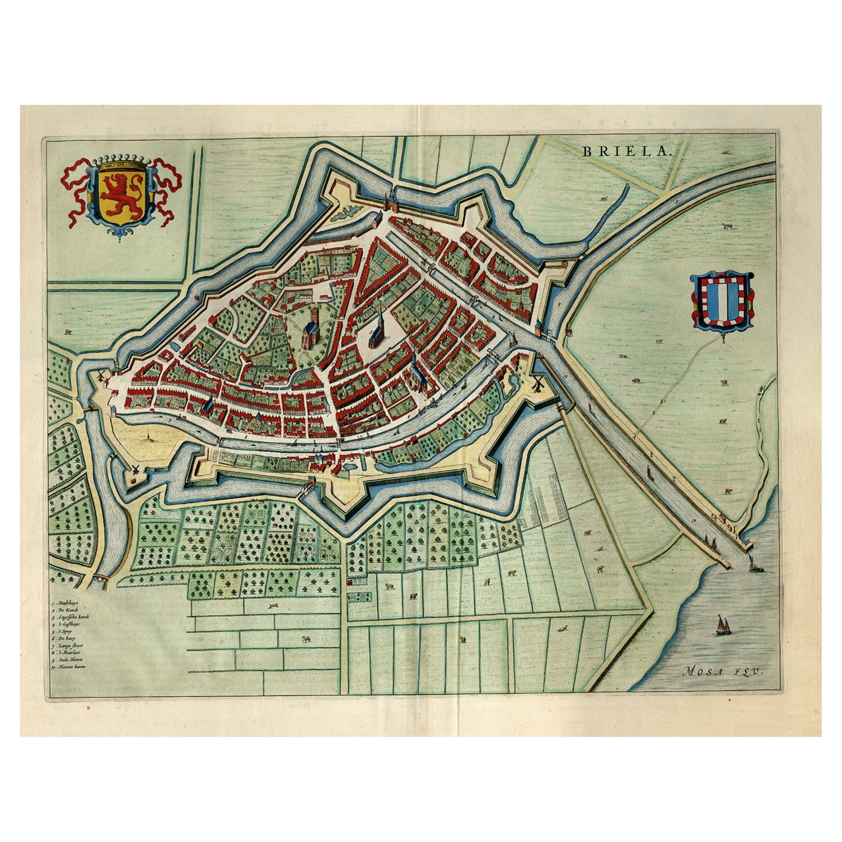
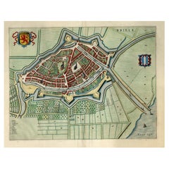
- Great Antique Bird's-Eye View Plan of Brielle by Blaeu in The Netherlands, 1649Located in Langweer, NLAntique print, titled: 'Briela.' Bird's-eye view plan of Brielle in The Netherlands. With key to locations and coats of arms. Text in Dutch on verso. This plan originates from the famous city Atlas: 'Toneel der Steeden' published by Joan Blaeu...Category
Antique 1640s Maps
MaterialsPaper
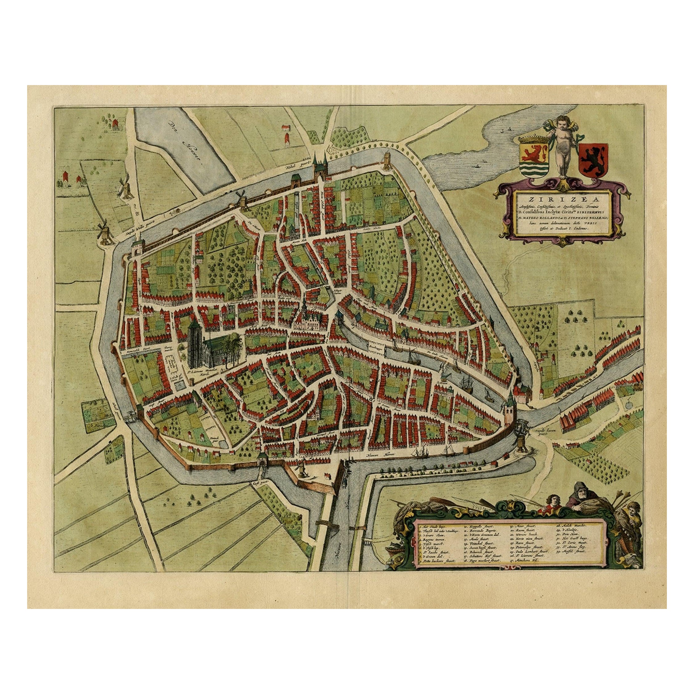
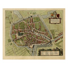
- Antique Bird's-eye View Plan of Zierikzee in Zeeland, The Netherlands, 1649Located in Langweer, NLAntique print, titled: 'Zirizea.' - A bird's-eye view plan of Zierikzee in The Netherlands, with key to locations and coats of arms. After Matheo Rollando and Stephano Bellemo. Latin tekst on verso. From the city Atlas: 'Toneel der Steeden' published by Joan Blaeu...Category
Antique 1640s Maps
MaterialsPaper
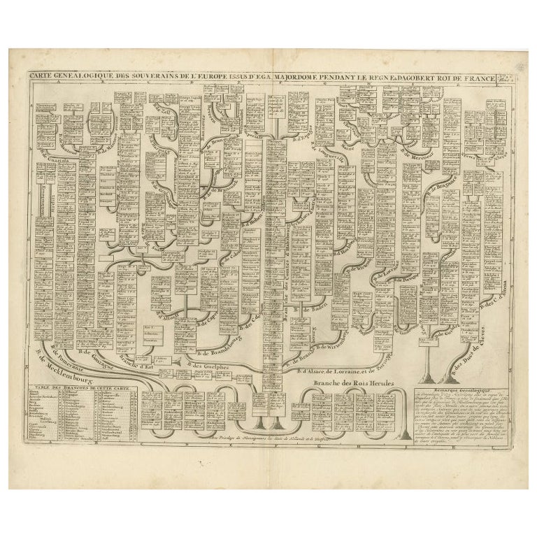
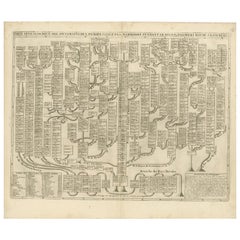
- Antique Genealogy Chart of the Leaders of Europe by Chatelain, 1732Located in Langweer, NLAntique print titled 'Carte Genealogique des Souverains de l'Europe (..)'. Chart of the royal line of the great Frankish major, Aega. As early as the 14th century the Hapsburgs attem...Category
Antique 18th Century Prints
MaterialsPaper
You May Also Like
- Original Antique Map / City Plan of Brussels by Tallis, circa 1850Located in St Annes, LancashireGreat map of Brussels. Steel engraving. Published by London Printing & Publishing Co. (Formerly Tallis), C.1850 Free shipping.Category
Antique 1850s English Maps
MaterialsPaper
- Original Antique Map of The Netherlands, Engraved by Barlow, Dated 1807Located in St Annes, LancashireGreat map of Netherlands Copper-plate engraving by Barlow Published by Brightly & Kinnersly, Bungay, Suffolk. Dated 1807 Unframed.Category
Antique Early 1800s English Maps
MaterialsPaper
- Original Antique Map of The Netherlands, Sherwood, Neely & Jones, Dated 1809Located in St Annes, LancashireGreat map of The Netherlands Copper-plate engraving by Cooper Published by Sherwood, Neely & Jones. Dated 1809 Unframed.Category
Antique Early 1800s English Maps
MaterialsPaper
- Civil War Panorama of the Seat of War by John Bachmann, Antique Print circa 1864Located in Colorado Springs, COPanorama of the seat of war. Bird's-eye View of Virginia, Maryland, Delaware and the District of Columbia. This third state of this fascinating bird's eye view of the northernmost p...Category
Antique 1860s American Maps
MaterialsPaper
- Original Antique Map of Belgium by Tallis, Circa 1850Located in St Annes, LancashireGreat map of Belgium Steel engraving Many lovely vignettes Published by London Printing & Publishing Co. ( Formerly Tallis ), C.1850 Origin...Category
Antique 1850s English Maps
MaterialsPaper
- Map of the Holy Land "Carte de la Syrie et de l'Egypte" by Pierre M. LapieBy Pierre M. LapieLocated in Alamo, CAAn early 19th century map of ancient Syria and Egypt entitled "Carte de la Syrie et de l'Egypte anciennes/dressée par M. Lapie, Colonel d'Etat Major, et...Category
Antique Early 19th Century French Maps
MaterialsPaper


Recently Viewed
View AllMore Ways To Browse
Antique Costume Print
Antique Colored Prints
Small Antique Prints
Wall Chart
Antique Print English Furniture
Steel Engraving
Antique Victorian Wood Architecturals
Set Antique Lithographs
Set Of Antique Lithographs
Amsterdam 18th
Antique Print Set England
Antique Wall Coverings
Antique Victorian Birds
18th Wall Decor
Art Deco Wall Art Prints
Antique Wall Covering
Antique Religion Print
Wall Statue