Items Similar to Vintage German Map Rhineland Rollable Wall Chart Poster Print

Want more images or videos?
Request additional images or videos from the seller
1 of 8
Vintage German Map Rhineland Rollable Wall Chart Poster Print
$420
£320.67
€370.53
CA$589.60
A$657.17
CHF 344.80
MX$8,025.13
NOK 4,365.86
SEK 4,126.40
DKK 2,765.42
About the Item
A country core vintage pull-down map illustrating the popular German region of the Rhineland, published by Westermann. Colorful print on paper reinforced with canvas.
Measurements:
Width 147 cm (57.87 inch)
Height 212.50 cm (83.66 inch)
The measurements shown refer just to the canvas and do not include the poles.
Background information on the history of school wall charts:
The idea to upgrade every day school life by using pictures was supported in the late 18th century by Johann Bernhard Basedow. In 1774 he published a four-volume book "Elementarwerk" which combined pictures, text and information with merely hundred copperplates. Modern printing methods enabled the spread from rich private schools to rural grade schools. From 1820-1836 the oldest mentioned series of wall charts were published with the range of six booklets including 63 large sized charts. The rising 20th century was the golden age for publishers printing wall charts. Artists Masterly performed pictures which combined the subject-specific standards of a scientist with the standards given by an educator and finally created a magnificent art work.
artfour is an owner-managed trading company dealing in Black Forest woodcarvings, antler furniture and an impressive variety of unique decorative items. Our antiques are displayed in a 100 years old barn in southern Germany which we have remodeled ourselves. Antique pieces have been our passion since the 1980s. We ship worldwide, perfectly packed and with money back guarantee. This qualifies us as your preferred partner for Black Forest and antique art.
- Dimensions:Height: 83.86 in (213 cm)Width: 57.88 in (147 cm)Depth: 0.79 in (2 cm)
- Style:Country (In the Style Of)
- Materials and Techniques:
- Place of Origin:
- Period:
- Date of Manufacture:circa 1960
- Condition:Wear consistent with age and use. The wall chart has been utilised and therefore shows age-related traces of usage. During storage the chart might partly be fissured, stained, sometimes smells and may have some old repairs. Please contact us for a detailed report .
- Seller Location:Berghuelen, DE
- Reference Number:Seller: k14111stDibs: LU988723556272
About the Seller
5.0
Platinum Seller
Premium sellers with a 4.7+ rating and 24-hour response times
Established in 1989
1stDibs seller since 2013
642 sales on 1stDibs
Typical response time: 2 hours
- ShippingRetrieving quote...Shipping from: Berghuelen, Germany
- Return Policy
Authenticity Guarantee
In the unlikely event there’s an issue with an item’s authenticity, contact us within 1 year for a full refund. DetailsMoney-Back Guarantee
If your item is not as described, is damaged in transit, or does not arrive, contact us within 7 days for a full refund. Details24-Hour Cancellation
You have a 24-hour grace period in which to reconsider your purchase, with no questions asked.Vetted Professional Sellers
Our world-class sellers must adhere to strict standards for service and quality, maintaining the integrity of our listings.Price-Match Guarantee
If you find that a seller listed the same item for a lower price elsewhere, we’ll match it.Trusted Global Delivery
Our best-in-class carrier network provides specialized shipping options worldwide, including custom delivery.More From This Seller
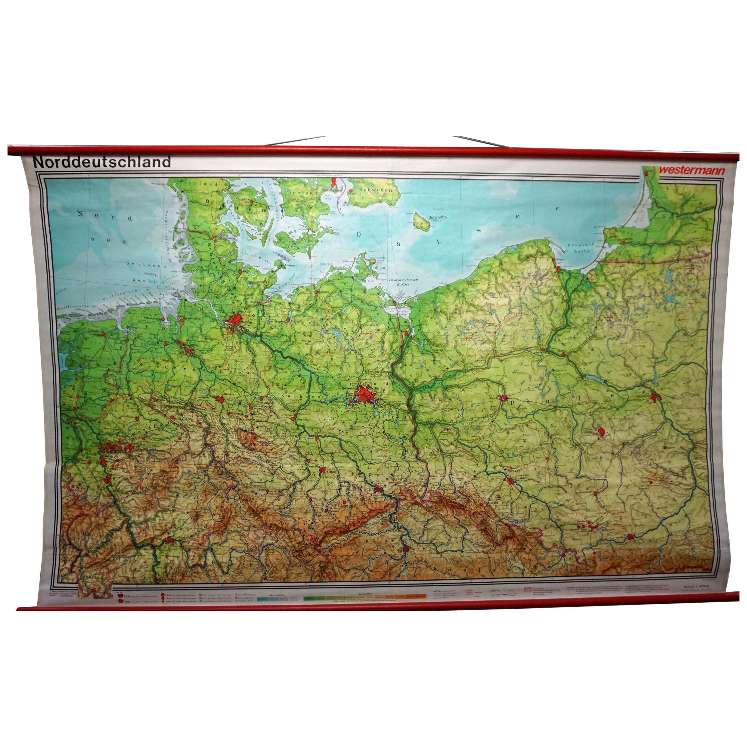
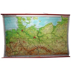
View AllVintage Rollable Map Northern Germany Poland Seaside Wallchart Baltic Sea
Located in Berghuelen, DE
The large impressive cottagecore pull-down map illustrates Northern Germany, Poland and parts of the Baltic Sea. It was published by Westermann-Schulwandkar...
Category
Late 20th Century German Country Prints
Materials
Canvas, Wood, Paper
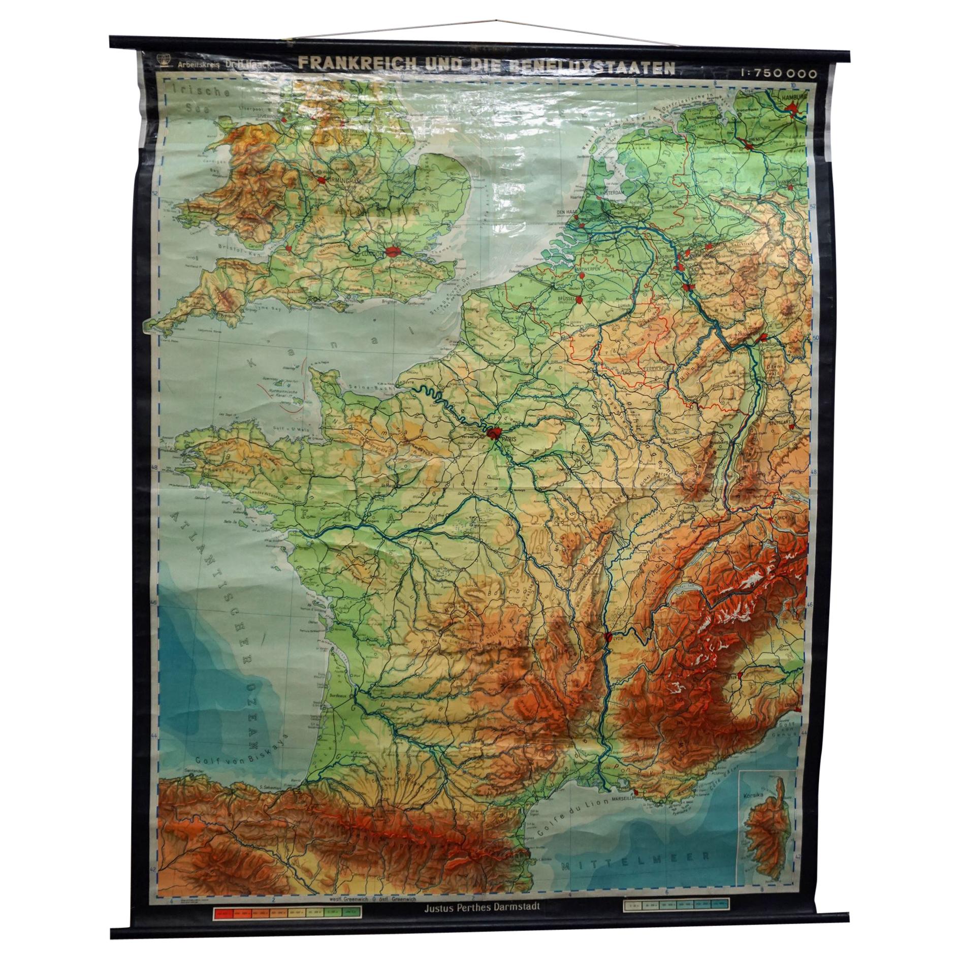
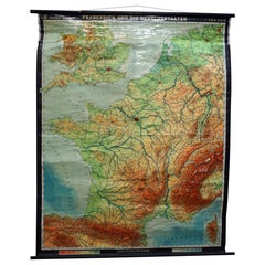
Vintage Mural Rollable Map Wall Chart France Benelux Countries South England
Located in Berghuelen, DE
A cottagecore pull-down wall chart map illustrating France and the Benelux countries (the Netherlands, Belgium and Luxemburg) and main parts of Western Europe. Published by Justus Pe...
Category
Mid-20th Century German Country Prints
Materials
Canvas, Wood, Paper
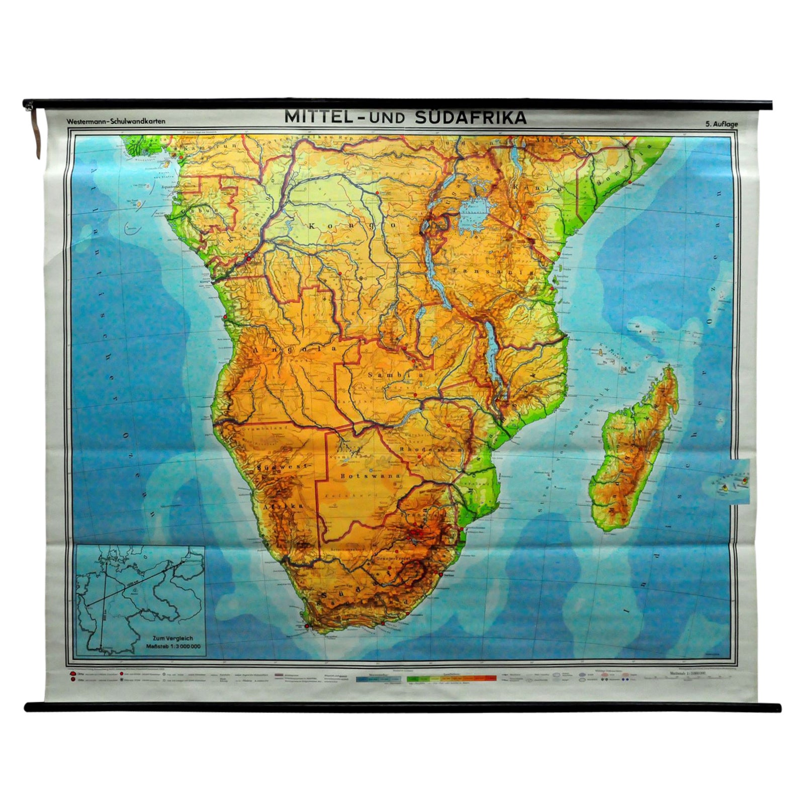
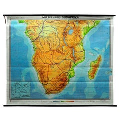
Countrycore Mural Vintage Map Wall Chart Rollable Poster Central South Africa
Located in Berghuelen, DE
The cottagecore pull-down mural map depicts Middle and South Africa. Published by Westermann. Colorful print on paper reinforced with canvas. A great scroll picture with a vintage lo...
Category
Vintage 1970s German Country Posters
Materials
Canvas, Wood, Paper
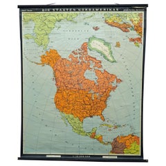
Vintage Map Wall Chart Countries of North America Rollable Mural Poster
Located in Berghuelen, DE
The vintage pull-down school map illustrates the countries / states of North America. Published by Haack-Painke Justus Perthes Darmstadt. Colorful print on paper reinforced with canv...
Category
Late 20th Century German Country Prints
Materials
Canvas, Wood, Paper
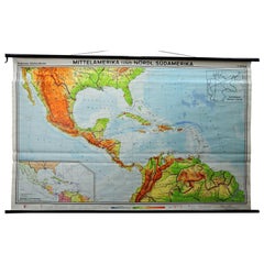
Large Rollable Map Central America Northern South America Wall Chart Poster
Located in Berghuelen, DE
A fantastic pull-down wall chart depicting a map of Central America and Northern South America. Used as teaching material in German schools. Colorful print on paper reinforced with c...
Category
Mid-20th Century German Country Prints
Materials
Canvas, Wood, Paper
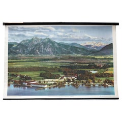
Pre-Alpine Landscape Foothills Bavaria Chiemsee Vintage Rollable Wall Chart
Located in Berghuelen, DE
The cottagecore vintage pull-down wallchart shows a pre-alpine landscape at the famous Chiemsee in Bavaria. Published by der Neue Schulmann, Fricke & Co. Stuttgart. Colorful print on...
Category
Vintage 1970s German Country Prints
Materials
Canvas, Wood, Paper
You May Also Like
Antique Map of the Rhineland and Alsace Region with Original Hand Coloring
Located in Langweer, NL
Antique map titled 'Palitinat du Rhein, Alsace, et partie de Souabe de Franconie (..)'. Double-page engraved map of the Rhineland and Alsace with original/contemporary hand coloring....
Category
Antique Mid-17th Century Maps
Materials
Paper
$292 Sale Price
20% Off
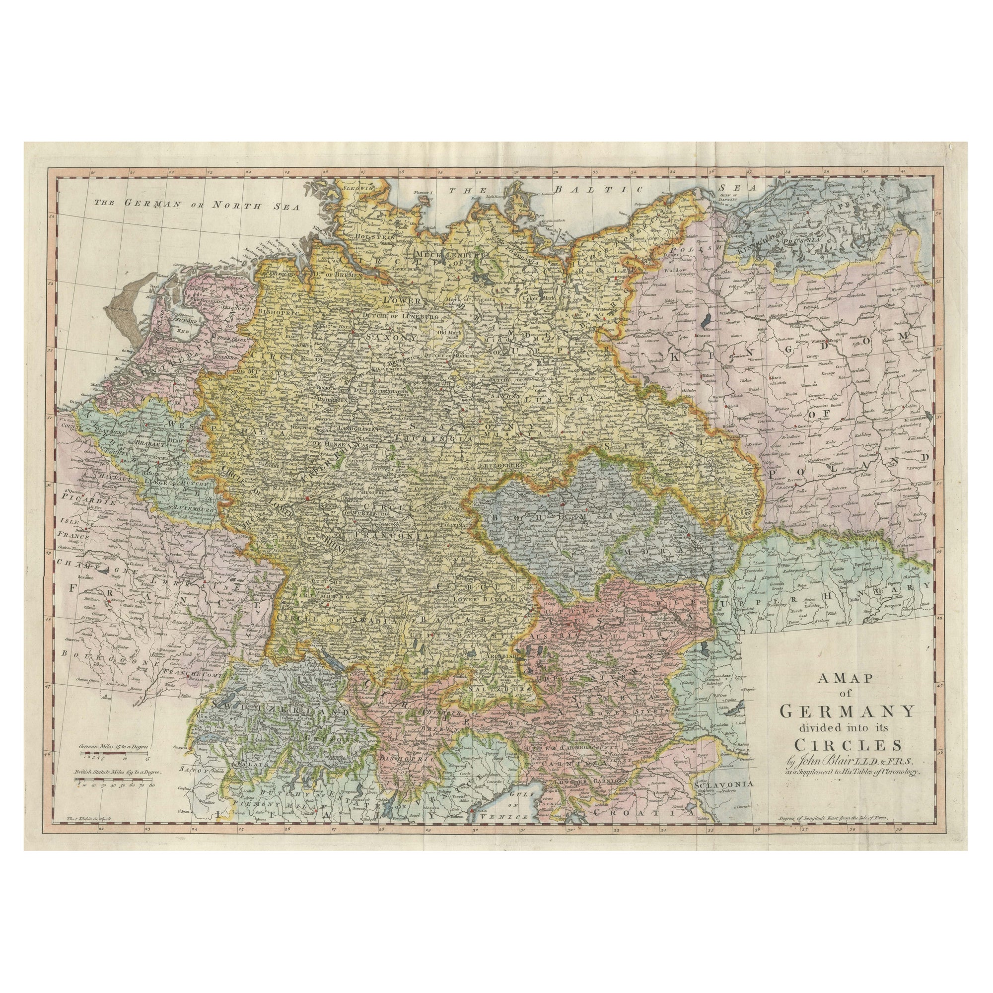
Large Antique Map of the German Empire
Located in Langweer, NL
Antique map titled 'A Map of Germany (..)'. Large antique map of the German Empire, highly detailed. Engraved by T. Kitchin. Published J. Blair, cir...
Category
Antique Late 18th Century Maps
Materials
Paper
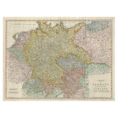
$641 Sale Price
20% Off
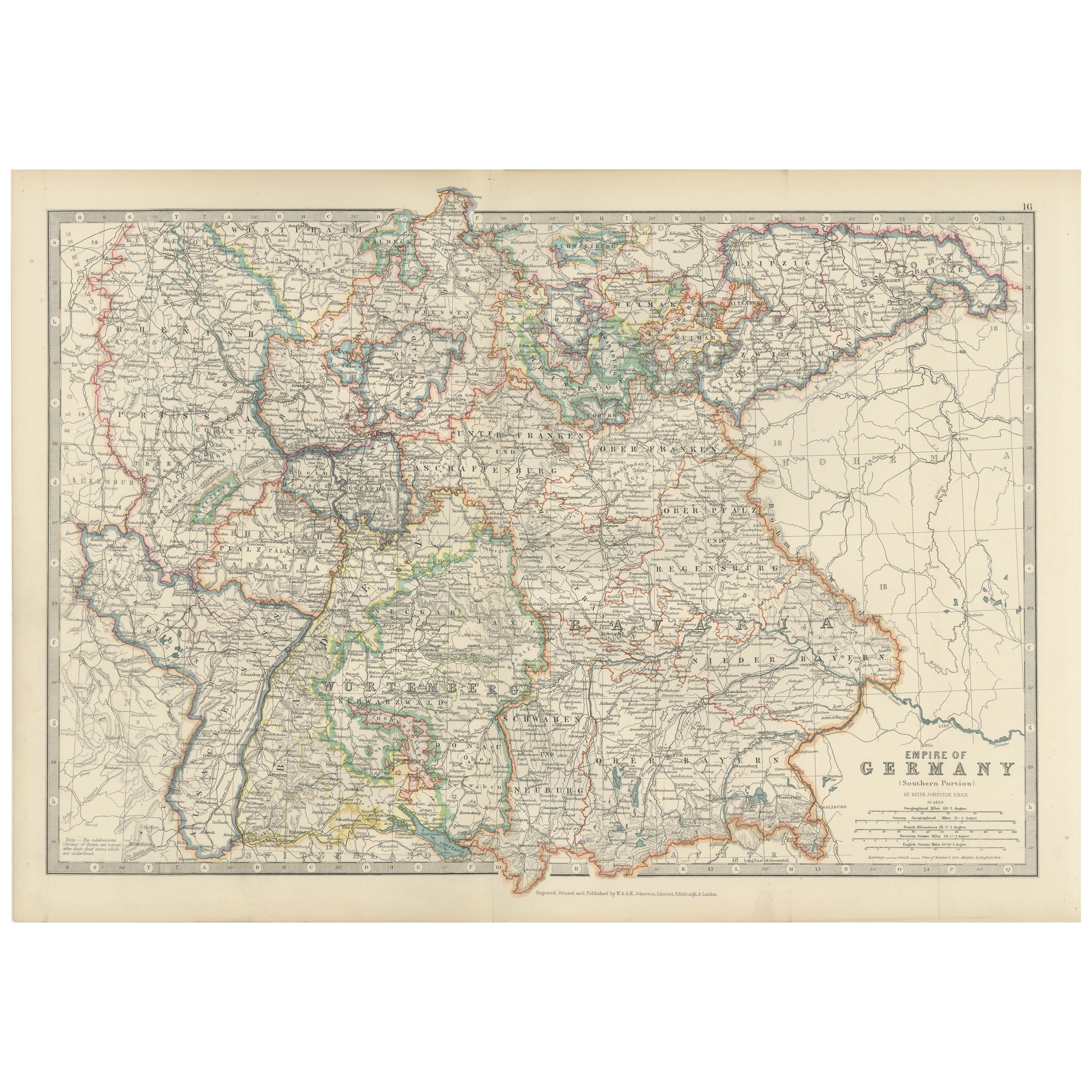
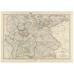
Antique Map of the German Empire, 1903, with Intricate Provincial Boundaries
Located in Langweer, NL
Title: Antique Map of the German Empire, 1903, with Intricate Provincial Boundaries
Description:
This antique map, titled "Empire of Germany (Southern Portion)," was engraved and pu...
Category
Early 20th Century Maps
Materials
Paper
Antique Map of Central Europe Showing The Railways and The Political Bounderies
Located in Langweer, NL
Explore the Heart of Europe with the 'Central Europe' Map, Featuring Principal Railways and Political Boundaries! This map offers a captivating view of the dynamic landscapes and pol...
Category
Antique 1880s Maps
Materials
Paper

$160 Sale Price
20% Off
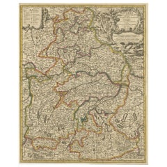
Antique Map of Germany and Central Europe
Located in Langweer, NL
Antique map titled 'S. Imperium Romano-Germanicum oder Teutschland mit seinen angrantzenden Königreichen und Provincien'. Original antique map of Germany...
Category
Antique Late 17th Century Maps
Materials
Paper

$1,037 Sale Price
20% Off
Antique Map of Bavaria, Bayern, with original Hand Coloring
Located in Langweer, NL
Antique map titled 'Bavariae Circulus atq Electoratus tam cum Adiacentibus quam insertis Regionibus'. Original old map of Bavaria, Bayern, Germany. The map stretches south to Innsbru...
Category
Antique Late 17th Century Maps
Materials
Paper
$443 Sale Price
20% Off