Items Similar to 1630 Pierre Petit map "Description du Gouvernement de la Capelle" Ric0010


Want more images or videos?
Request additional images or videos from the seller
1 of 12
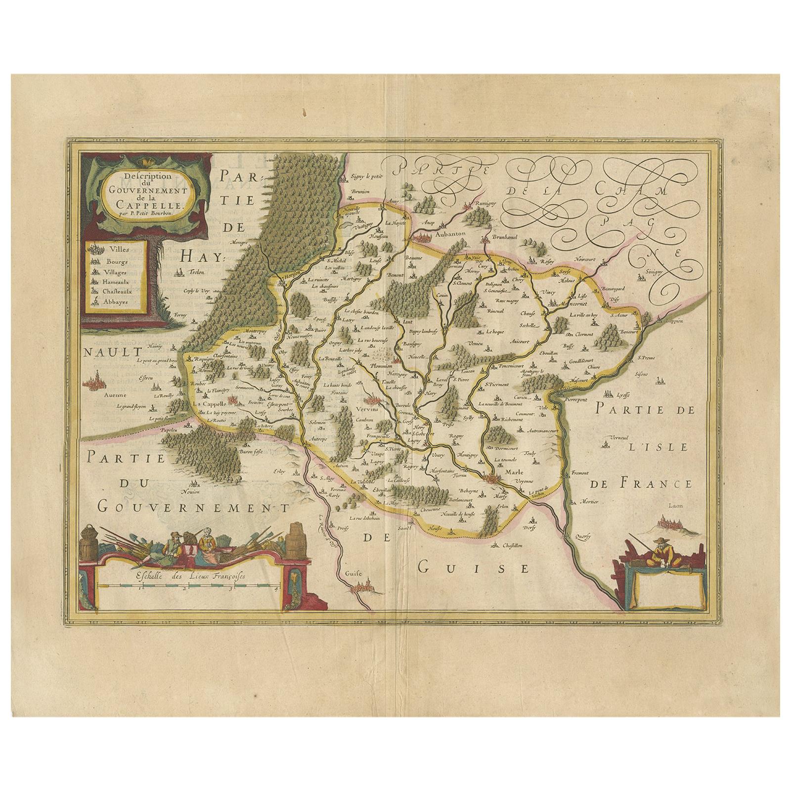
1630 Pierre Petit map "Description du Gouvernement de la Capelle" Ric0010
$1,475
£1,112.30
€1,286.42
CA$2,069.42
A$2,300.29
CHF 1,205.76
MX$28,092.05
NOK 15,053.22
SEK 14,162.28
DKK 9,601.50
About the Item
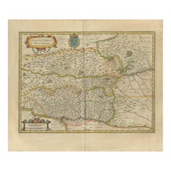
1630 Pierre Petit map entitled
"Description du Gouvernement de la Capelle,"
Ric0010
Pierre Petit was the son of a minor provincial official in Montluçon. The town, in the Auvergne region of central France, is situated northwest of Clermont-Ferrand. The old town in which Pierre was brought up was on a hill dominated by a château. After being educated in Montluçon he followed his father into local government and spent the first years of his adult life as 'contrôleur de l'election' in the town of his birth. As Petit was much involved in the government of France, we should look briefly at political events of the times in which he lived.
Louis XIII had become King of France in 1610, around the time Petit was thinking about a career in government. The fact that Louis XIII's father Henry IV had been assassinated by a fanatical Roman Catholic, and Louis was only nine years old when he succeeded to the throne, already gives some idea of the political situation. It was a time of revolt by the French peasants, and officials loyal to the government were in some danger of assassination.
In 1633 Petit moved to Paris to play a role in national rather than local government. Being in Paris had another advantage for Petit since it allowed him to become more involved with men of science than he could be in a town like Montluçon. Richelieu, a major figure in the French government, had begun with a career in the Church and, as Bishop of Luçon, became involved with the government in the difficult period when Louis XIII was a minor. The King managed to get Richelieu made a Cardinal, then appointed him as secretary of state in 1624, giving him the title of first minister four years later. When Petit arrived in Paris in 1633 he was appointed 'Commissaire Provincial de l'Artillerie' by Richelieu.
In Paris Petit joined with the group of scientists meeting with Mersenne at the Minims de l'Annociade near Place Royale. In the year Petit arrived in Paris, Mersenne published Traité des mouvements, and in the following year he published Les Mécanique de Galilée which was a version of Galileo's lectures on mechanics. Étienne Pascal had arrived in Paris two years before Petit so that his son could have the best education. He and his son Blaise Pascal were also members of Mersenne's group as were others such as Gassendi, Roberval, and Beaugrand.
Petit was an influential figure with important government positions which enabled him to try to influence national science policy. A firm believer, as were the other members of Mersenne's group, of the experimental method rather than the philosophical approach advocated by Descartes, Petit argued strongly for better astronomical facilities in France. He wanted the King to establish a Royal Observatory to allow France to again take a leading role in astronomy. Petit argued that France had fallen behind some other European countries and was relying on observations made in other countries. Petit himself had a fine collection of astronomical instruments and several of these were of his own invention. In particular, late in his life, Petit devised a filar micrometer to measure the diameters of celestial objects such as the Sun, Moon and planets. By this time Petit was 'Intendant Général des Fortifications', a position he was appointed to in 1649, and he wrote a letter which describes the instrument. This was published in the Journal des sçavans in May 1667 as Extrait d'une lettre de M Petit Intendant des Fortifications ... touchant une nouvelle machine pour mesurer exactment les diamètres des astres. Petit's instrument was later used by Giovanni Cassini in the Royal Observatory in Paris.
Among many collaborations, Petit worked with Étienne Pascal and his son Blaise Pascal in October 1646 in repeating Torricelli's experiment on the barometric vacuum. Petit wrote an account of these experiments which were published as Observation touchant le vuide faite pour la première fois en France in 1647. Petit kept up a regular correspondence with the secretary of the Royal Society in London after its foundation in 1660 and was one of the first foreign fellows of that Society when elected in April 1667. Petit had written Dissertation sur la nature des comètes in 1665 which had been highly praised by the Royal Society and must have played a large role in him being elected a fellow.
Petit had argued strongly in favour of setting up an official scientific organisation in France so it is rather surprising that when the Académie des Sciences was founded in Paris in 1666 by Jean-Baptiste Colbert, at that time controller general of finance in France, Petit was not made a member. Colbert's programme of economic reconstruction was largely responsible for making France the leading power in Europe. There surely were personal reasons why Colbert, whose aims were so close to those of Petit, chose to ignore him when he drew up the initial list of members.
Dimension: Paper: 57 cm W x 48 cm H) ; Sight: 49 cm W x 37 cm H
Condition: Good Condition with some torn on the edge, please see photos.
- Dimensions:Height: 18.9 in (48 cm)Width: 22.45 in (57 cm)Depth: 0.4 in (1 cm)
- Materials and Techniques:
- Place of Origin:
- Period:
- Date of Manufacture:1630
- Condition:
- Seller Location:Norton, MA
- Reference Number:1stDibs: LU5848230174092
About the Seller
5.0
Gold Seller
Premium sellers maintaining a 4.3+ rating and 24-hour response times
Established in 2000
1stDibs seller since 2021
119 sales on 1stDibs
Typical response time: <1 hour
- ShippingRetrieving quote...Shipping from: Norton, MA
- Return Policy
Authenticity Guarantee
In the unlikely event there’s an issue with an item’s authenticity, contact us within 1 year for a full refund. DetailsMoney-Back Guarantee
If your item is not as described, is damaged in transit, or does not arrive, contact us within 7 days for a full refund. Details24-Hour Cancellation
You have a 24-hour grace period in which to reconsider your purchase, with no questions asked.Vetted Professional Sellers
Our world-class sellers must adhere to strict standards for service and quality, maintaining the integrity of our listings.Price-Match Guarantee
If you find that a seller listed the same item for a lower price elsewhere, we’ll match it.Trusted Global Delivery
Our best-in-class carrier network provides specialized shipping options worldwide, including custom delivery.More From This Seller
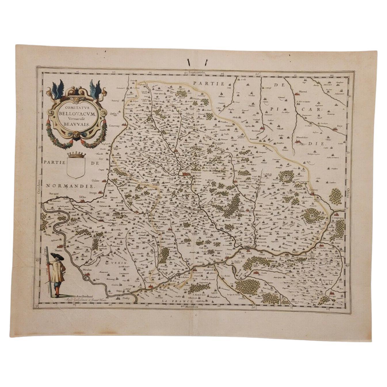
View All1635 Willem Blaeu Map of Northern France"Comitatvs Bellovacvm" Ric.a08
Located in Norton, MA
1635 Willem Blaeu map of northern France, entitled.
"Comitatvs Bellovacvm Vernacule Beavvais,"
Colored
Ric.a008
“COMITATVS BELLOVACVM…” Amsterdam: W...
Category
Antique 17th Century Unknown Maps
Materials
Paper

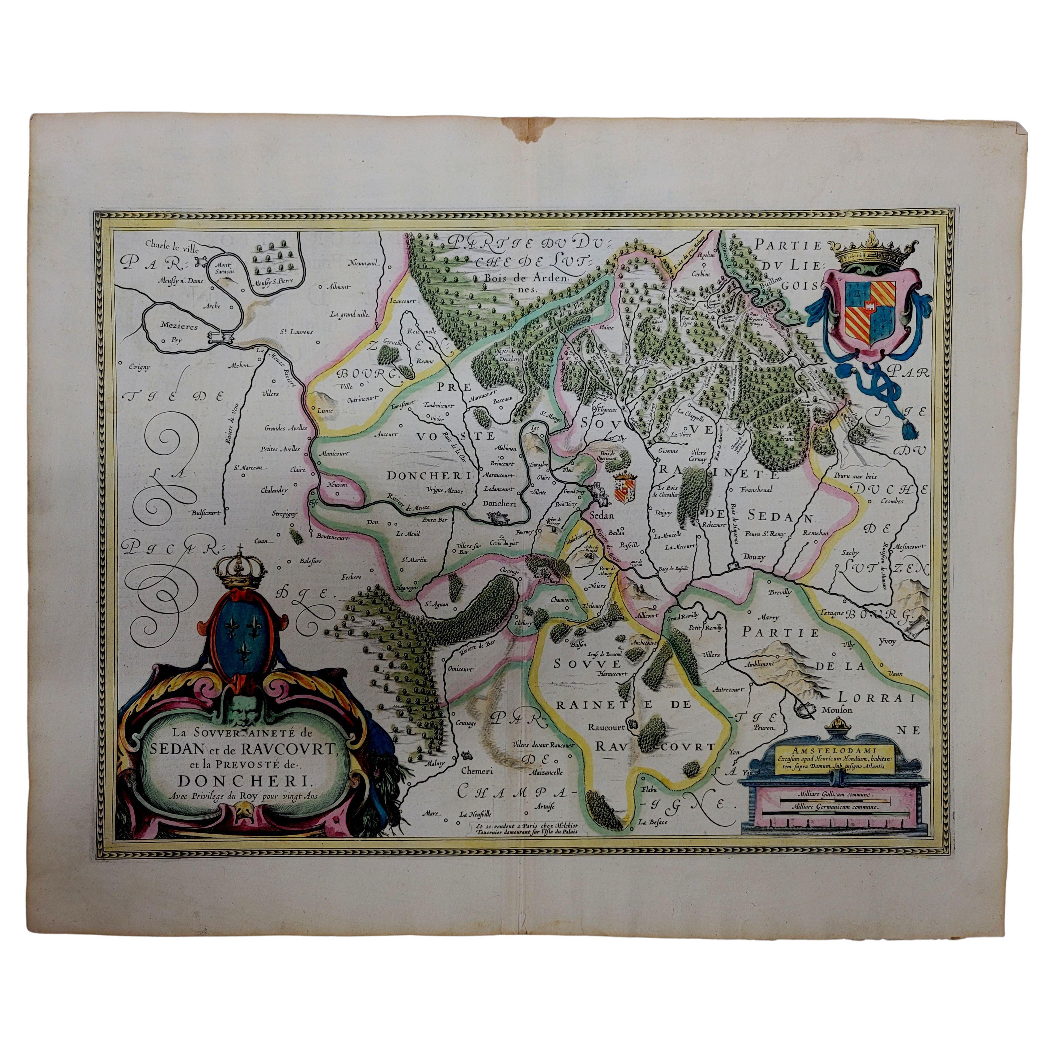
1633 Map "La Souverainete De Sedan Et De Raucourt, Et La Prevoste Ric0011
Located in Norton, MA
1653 map entitled
"La Souverainete de Sedan et de Raucourt, et la Prevoste de Doncheri,"
Ric0011
Description:
Lovely map centered on Sedan and Doncheri and the Meuze River fr...
Category
Antique 17th Century Dutch Maps
Materials
Paper

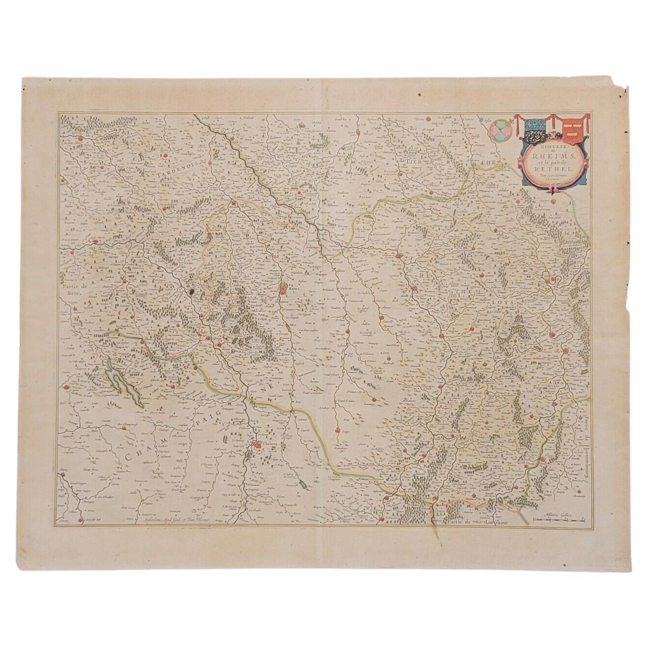
1640 Joan Bleau Map Entitled"Diocecese de rheims et le pais de rethel, " Eic.a011
Located in Norton, MA
1640 Joan Bleau map entitled
"Diocecese de rheims et le pais de rethel,"
Ric.a011
OAN BLAEU
Diocecese de Rheims, et le pais de Rethel.
Handcolored engraving, c.1640.
...
Category
Antique 17th Century Dutch Maps
Materials
Paper

1633 Map Entitled "Beauvaisis Comitatus Belova Cium, Ric.0002
Located in Norton, MA
1633 map entitled
"Beauvaisis Comitatus Belova Cium,"
Hand Colored
Ric.0002
Description: Cartographer : - Hondius, Henricus 1587-1638
Artists and Engravers:Jodocus Hondius, one of the most notable engravers of his time. He is known for his work in association with many of the cartographers and publishers prominent at the end of the sixteenth and the beginning of the seventeenth century. A native of Flanders, he grew up in Ghent, apprenticed as an instrument and globe maker and map engraver. In 1584, to escape the religious troubles sweeping the Low Countries at that time, he fled to London where he spent some years before finally settling in Amsterdam about 1593. In the London period he came into contact with the leading scientists and geographers of the day and engraved maps in The Mariner\\\\\\\\\\\\\\\'s Mirrour, the English edition of Waghenaer\\\\\\\\\\\\\\\'s Sea Atlas, as well as others with Pieter van den Keere, his brother-in-law. No doubt his temporary exile in London stood him in good stead, earning him an international reputation, for it could have been no accident that Speed chose Hondius to engrave the plates for the maps in The Theatre of the Empire of Great Britaine in the years between 1605 and 1610. In 1604 Hondius bought the plates of Mercator\\\\\\\\\\\\\\\'s Atlas which, in spite of its excellence, had not competed successfully with the continuing demand for the Ortelius Theatrum Orbis Terrarum. To meet this competition Hondius added about 40 maps to Mercator\\\\\\\\\\\\\\\'s original number and from 1606 published enlarged editions in many languages, still under Mercator\\\\\\\\\\\\\\\'s name but with his own name as publisher. These atlases have become known as the Mercator/Hondius series. The following year the maps were reengraved in miniature form and issued as a pocket Atlas Minor. After the death of Jodocus Hondius the Elder in 1612, work on the two atlases, folio and miniature, was carried on by his widow and sons, Jodocus II and Henricus, and eventually in conjunction with Jan Jansson in Amsterdam.
In all, from 1606 onwards, nearly 50 editions with increasing numbers of maps with texts in the main European languages were printed. Summaries of these issues are given under the entry for Gerard Mercator. Jodocus Hondius the Elder * 1588 Maps in The Mariner\\\\\\\\\\\\\\\'s Mirrour (Waghenaer/Ashley) * 1590 World Map...
Category
Antique 17th Century Dutch Maps
Materials
Paper

1590 Mercator Map Entitled "France Picardie Champaigne, Ric.0001
Located in Norton, MA
Description: Published in Amsterdam by Mercator/Hondius ca. 1590.
Ric.0001
Artists and Engravers: Map : 'France Picardie Champaigne cum regionibus adiacentibus'. (Map of the french provinces of Picardie and Champagne.) Copper engraved map of the french provinces of Picardie and Champagne, showing the cities of Caen, Paris, Melun, Auxerre, Verdun, etc. Copperplate engraving on verge type hand laid paper with watermark. Description: Published in Amsterdam by Mercator/Hondius ca. 1600.Artists and Engravers: Mercator was born in Rupelmonde in Flanders and studied in Louvain under Gemma Frisius, Dutch writer, astronomer and mathematician. The excellence of his work brought him the patronage of Charles V, but in spite of his favor with the Emperor he was caught up in the persecution of Lutheran protestants and charged with heresy, fortunately without serious consequences. No doubt the fear of further persecution influenced his move in 1552 to Duisburg, where he continued the production of maps, globes and instruments. Mercator's sons and grandsons, were all cartographers and made their contributions in various ways to his atlas. Rumold, in particular, was responsible for the complete edition in 1595. The map plates...
Category
Antique 16th Century Dutch Maps
Materials
Paper

1594 Maurice Bouguereau Map of the Region Limoges, France, Ric0015
Located in Norton, MA
1594 Maurice Bouguereau map of the region Limoges, France, entitled
"Totivs Lemovici et Confinium Pro Uinciarum Quantum ad Dioecefin Lemo Uicenfen Fpectant,"
Hand Colored
Ric0015
Jean IV Le Clerc...
Category
Antique 16th Century Dutch Maps
Materials
Paper

You May Also Like
Antique Map of the Region of Hauts-de-France by Hondius, circa 1630
Located in Langweer, NL
Antique map titled 'Description du Gouvernement de la Cappelle'. Old map of the region of Hauts-de-France including the cities of Vervins, Marle, Cappelle and others. This map origin...
Category
Antique Mid-17th Century Maps
Materials
Paper

$477 Sale Price
20% Off
Antique Map of the Hainaut and Namur Region by Janssonius, 'circa 1640'
By Johannes Janssonius
Located in Langweer, NL
Antique map titled 'Comitatuum Hannoniae et Namurci Descriptio'. Old map of the region of Hainaut and Namur, France. Published by J. Janssonius, circa 1640.
Category
Antique Mid-17th Century Maps
Materials
Paper

$477 Sale Price
20% Off
Antique Map of the Region of Lyon by Hondius, circa 1630
Located in Langweer, NL
Antique map titled 'Lionnois, Forest et Beauiolois'. Old map of the former region of Lyon, Vienne, Bresse, Rohan and the Rhône River. This map originates f...
Category
Antique Mid-17th Century Maps
Materials
Paper
$477 Sale Price
20% Off
Rare 17th-Century Map of Dauphiné in Southeastern France by F. De Wit, ca.1688
Located in Langweer, NL
Title: Rare Hand-Colored 17th-Century Map of Dauphiné by Frederik De Wit c. 1688
Description: This captivating 17th-century map of Dauphiné, titled "Nova et Accurata Delphinatus Vul...
Category
Antique 1680s Maps
Materials
Paper

Antique Map of the Region of Beauvais by Hondius, circa 1630
Located in Langweer, NL
Antique map titled 'Beauvaisis - Comitatus Belovacium'. Old map of the region of Beauvais, France. This map originates from a composite atlas and is signed by J. Hondius.
Category
Antique Mid-17th Century Maps
Materials
Paper

$477 Sale Price
20% Off
Antique Map of the Region of Île-de-France by Hondius, circa 1630
Located in Langweer, NL
Antique map titled Gouvernement de l'Isle de France'. Old map of the region of Île-de-France, France. It is located in the north-central part of the country and often called the régi...
Category
Antique Mid-17th Century Maps
Materials
Paper

$524 Sale Price
20% Off
More Ways To Browse
Petit H
Louis Iv
Antique Vacuum
Henry Hill Furniture
Celestial Map
Antique Astronomical Instruments
French Provincial Secretary
Etienne Henry
17th Century Secretary
Bishop Throne
Antique Micrometers
Antique Maps Of Maryland
Gambia Antique Map
Antique Manitoba
Antique Map Of Brooklyn
Antique Map Of Michigan
Cham Antiques
Map Of Native American Tribes