Items Similar to 1714 Henri Chatelain "Nouvelle Carte Des Etatas Du Grand.Duc De Mos Moscovie Eur

Want more images or videos?
Request additional images or videos from the seller
1 of 9
1714 Henri Chatelain "Nouvelle Carte Des Etatas Du Grand.Duc De Mos Moscovie Eur
$375
£286.71
€330.23
CA$525.49
A$586.66
CHF 307.40
MX$7,181.30
NOK 3,904
SEK 3,680.97
DKK 2,464.53
Shipping
Retrieving quote...The 1stDibs Promise:
Authenticity Guarantee,
Money-Back Guarantee,
24-Hour Cancellation
About the Item
A 1714 Henri Chatelain map, entitled
"Nouvelle Carte Des Etatas Du Grand Duc De Moscovie En Europe,"
Ricb001
Henri Abraham Chatelain (1684-1743) was a Huguenot pastor of Parisian origins. Chatelain proved a successful businessman, creating lucrative networks in London, The Hague, and then Amsterdam. He is most well known for the Atlas Historique, published in seven volumes between 1705 and 1720. This encyclopedic work was devoted to the history and genealogy of the continents, discussing such topics as geography, cosmography, topography, heraldry, and ethnography. Published thanks to a partnership between Henri, his father, Zacharie, and his younger brother, also Zacharie, the text was contributed to by Nicolas Gueudeville, a French geographer. The maps were by Henri, largely after the work of Guillaume Delisle, and they offered the general reader a window into the emerging world of the eighteenth century.
Dimension: Paper Size: 18" W x 14" H (46 cm W x 36cm H)
Date: 18th Century
Condition: Good Condition with age, please see photos.
- Dimensions:Height: 14.18 in (36 cm)Width: 18.12 in (46 cm)Depth: 0.4 in (1 cm)
- Materials and Techniques:
- Place of Origin:
- Period:
- Date of Manufacture:1714
- Condition:
- Seller Location:Norton, MA
- Reference Number:1stDibs: LU5848230191662
About the Seller
5.0
Platinum Seller
Premium sellers with a 4.7+ rating and 24-hour response times
Established in 2000
1stDibs seller since 2021
116 sales on 1stDibs
Typical response time: <1 hour
- ShippingRetrieving quote...Shipping from: Norton, MA
- Return Policy
Authenticity Guarantee
In the unlikely event there’s an issue with an item’s authenticity, contact us within 1 year for a full refund. DetailsMoney-Back Guarantee
If your item is not as described, is damaged in transit, or does not arrive, contact us within 7 days for a full refund. Details24-Hour Cancellation
You have a 24-hour grace period in which to reconsider your purchase, with no questions asked.Vetted Professional Sellers
Our world-class sellers must adhere to strict standards for service and quality, maintaining the integrity of our listings.Price-Match Guarantee
If you find that a seller listed the same item for a lower price elsewhere, we’ll match it.Trusted Global Delivery
Our best-in-class carrier network provides specialized shipping options worldwide, including custom delivery.More From This Seller
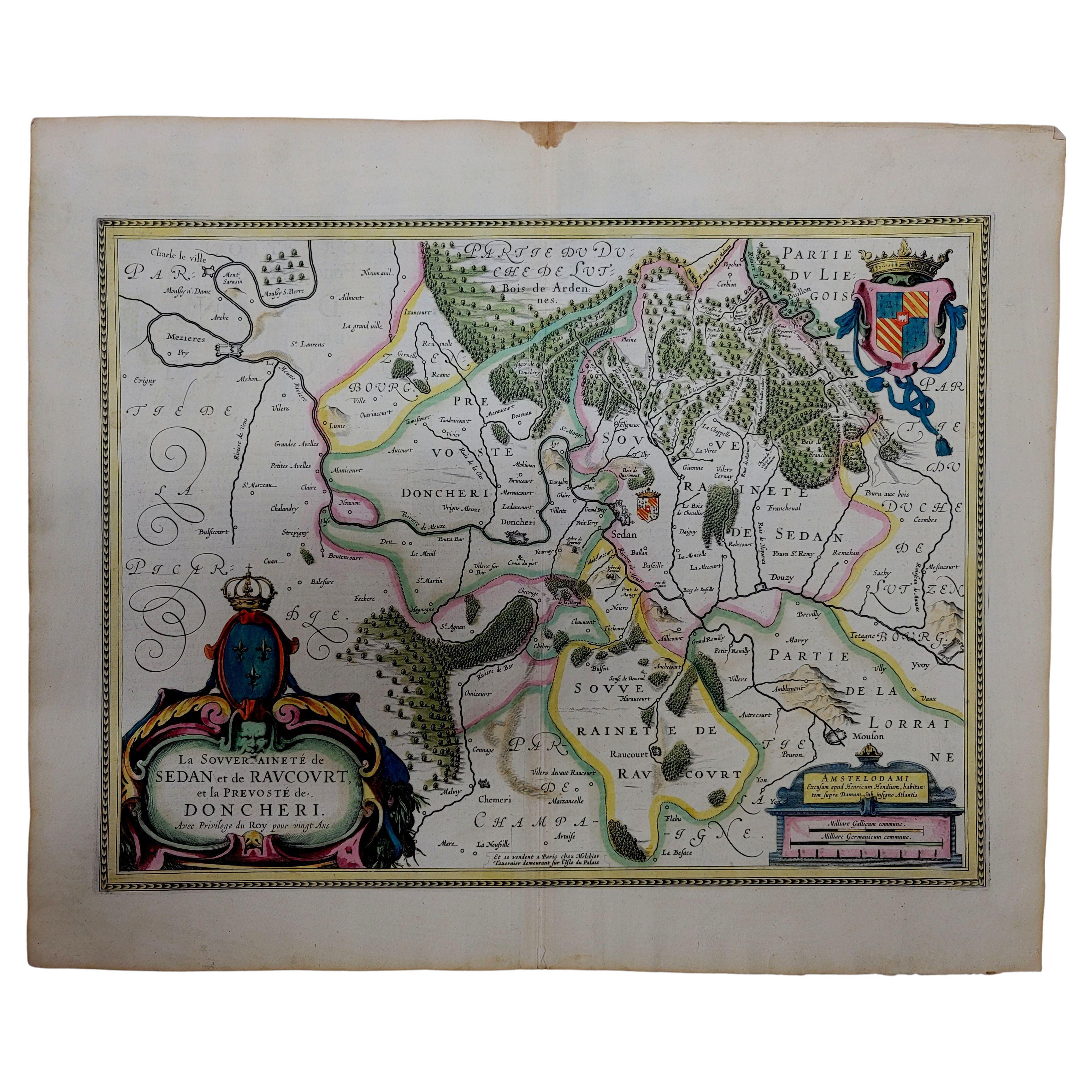
View All1633 Map "La Souverainete De Sedan Et De Raucourt, Et La Prevoste Ric0011
Located in Norton, MA
1653 map entitled
"La Souverainete de Sedan et de Raucourt, et la Prevoste de Doncheri,"
Ric0011
Description:
Lovely map centered on Sedan and Doncheri and the Meuze River fr...
Category
Antique 17th Century Dutch Maps
Materials
Paper

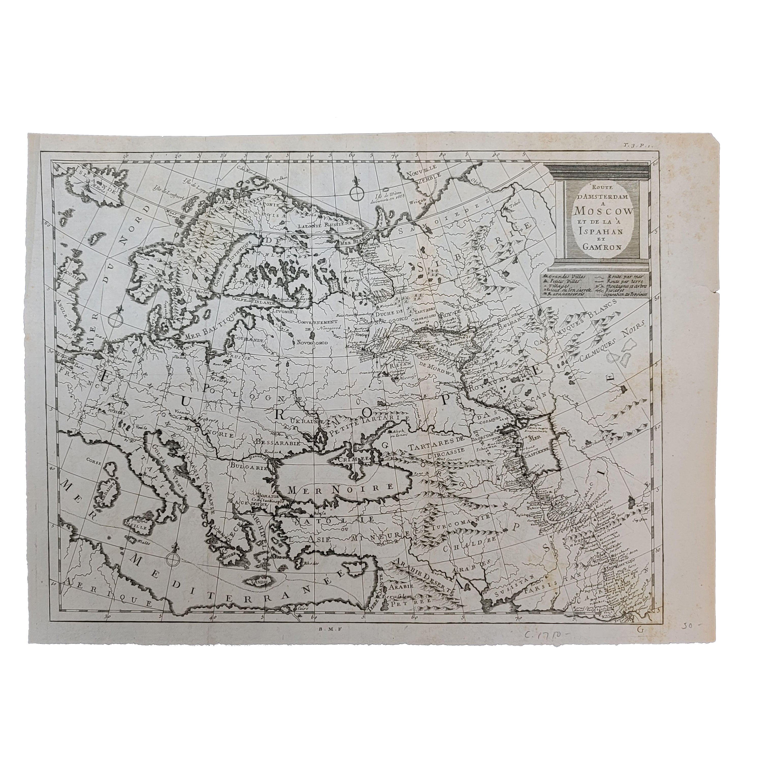
1718 Ides & Witsen Map "Route D'amsterdam a Moscow Et De La Ispahan Et Gamron
Located in Norton, MA
1718 Ides & Witsen map, entitled
"Route D'Amsterdam A Moscow Et De La Ispahan Et Gamron,"
Ric.b005
Subject: Eastern Europe and Central Asia
Period: 1718 (published)
Publicati...
Category
Antique Early 18th Century Dutch Maps
Materials
Paper

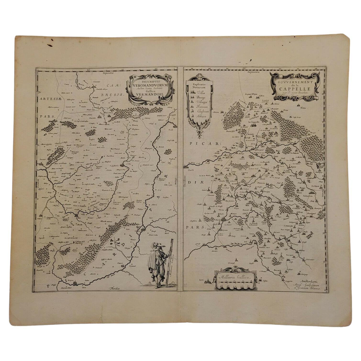
1657 Janssonius Map of Vermandois and Cappelle, Ric. A-004
Located in Norton, MA
1657 Janssonius map of
Vermandois and Cappelle
Ric.a004
Description: Antique map of France titled 'Descriptio Veromanduorum - Gouvernement de la Cappelle'. Two detailed maps o...
Category
Antique 17th Century Unknown Maps
Materials
Paper

1633 Map Entitled "Beauvaisis Comitatus Belova Cium, Ric.0002
Located in Norton, MA
1633 map entitled
"Beauvaisis Comitatus Belova Cium,"
Hand Colored
Ric.0002
Description: Cartographer : - Hondius, Henricus 1587-1638
Artists and Engravers:Jodocus Hondius, one of the most notable engravers of his time. He is known for his work in association with many of the cartographers and publishers prominent at the end of the sixteenth and the beginning of the seventeenth century. A native of Flanders, he grew up in Ghent, apprenticed as an instrument and globe maker and map engraver. In 1584, to escape the religious troubles sweeping the Low Countries at that time, he fled to London where he spent some years before finally settling in Amsterdam about 1593. In the London period he came into contact with the leading scientists and geographers of the day and engraved maps in The Mariner\\\\\\\\\\\\\\\'s Mirrour, the English edition of Waghenaer\\\\\\\\\\\\\\\'s Sea Atlas, as well as others with Pieter van den Keere, his brother-in-law. No doubt his temporary exile in London stood him in good stead, earning him an international reputation, for it could have been no accident that Speed chose Hondius to engrave the plates for the maps in The Theatre of the Empire of Great Britaine in the years between 1605 and 1610. In 1604 Hondius bought the plates of Mercator\\\\\\\\\\\\\\\'s Atlas which, in spite of its excellence, had not competed successfully with the continuing demand for the Ortelius Theatrum Orbis Terrarum. To meet this competition Hondius added about 40 maps to Mercator\\\\\\\\\\\\\\\'s original number and from 1606 published enlarged editions in many languages, still under Mercator\\\\\\\\\\\\\\\'s name but with his own name as publisher. These atlases have become known as the Mercator/Hondius series. The following year the maps were reengraved in miniature form and issued as a pocket Atlas Minor. After the death of Jodocus Hondius the Elder in 1612, work on the two atlases, folio and miniature, was carried on by his widow and sons, Jodocus II and Henricus, and eventually in conjunction with Jan Jansson in Amsterdam.
In all, from 1606 onwards, nearly 50 editions with increasing numbers of maps with texts in the main European languages were printed. Summaries of these issues are given under the entry for Gerard Mercator. Jodocus Hondius the Elder * 1588 Maps in The Mariner\\\\\\\\\\\\\\\'s Mirrour (Waghenaer/Ashley) * 1590 World Map...
Category
Antique 17th Century Dutch Maps
Materials
Paper

1627 Hendrik Hondius Map Entitled "Vltoniae Orientalis Pars, " Ric.a009
Located in Norton, MA
1627 Hendrik Hondius map entitled
"Vltoniae orientalis pars,"
Ric.a009
Title:
Vltoniae orientalis : pars
Title (alt.) :
Ultoniae orientalis pars
Creator:
Mercator, Gerh...
Category
Antique 17th Century Dutch Maps
Materials
Paper

1640 Joan Bleau Map Entitled"Diocecese de rheims et le pais de rethel, " Eic.a011
Located in Norton, MA
1640 Joan Bleau map entitled
"Diocecese de rheims et le pais de rethel,"
Ric.a011
OAN BLAEU
Diocecese de Rheims, et le pais de Rethel.
Handcolored engraving, c.1640.
...
Category
Antique 17th Century Dutch Maps
Materials
Paper

You May Also Like
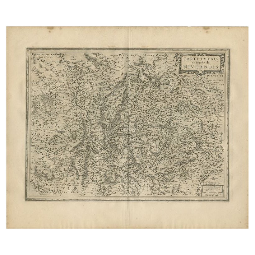
Antique Map of the Region of Nivernais by Janssonius, 1657
By Johannes Janssonius
Located in Langweer, NL
Antique map of France titled 'Carte du Païs et Duché de Nivernois'. Decorative map of the Nivernais region, part of Burgundy, France. This map originates from 'Atlas Novus, Sive Thea...
Category
Antique 17th Century Maps
Materials
Paper

$367 Sale Price
20% Off
Antique Map of Beauce by Janssonius, 1657
By Johannes Janssonius
Located in Langweer, NL
Antique map 'Belsia vulgo la Beausse'. Decorative map of the region of Beauce, a natural region in northern France, located between the Seine and Loire rivers. This map originates fr...
Category
Antique Mid-17th Century Maps
Materials
Paper

$472 Sale Price
20% Off
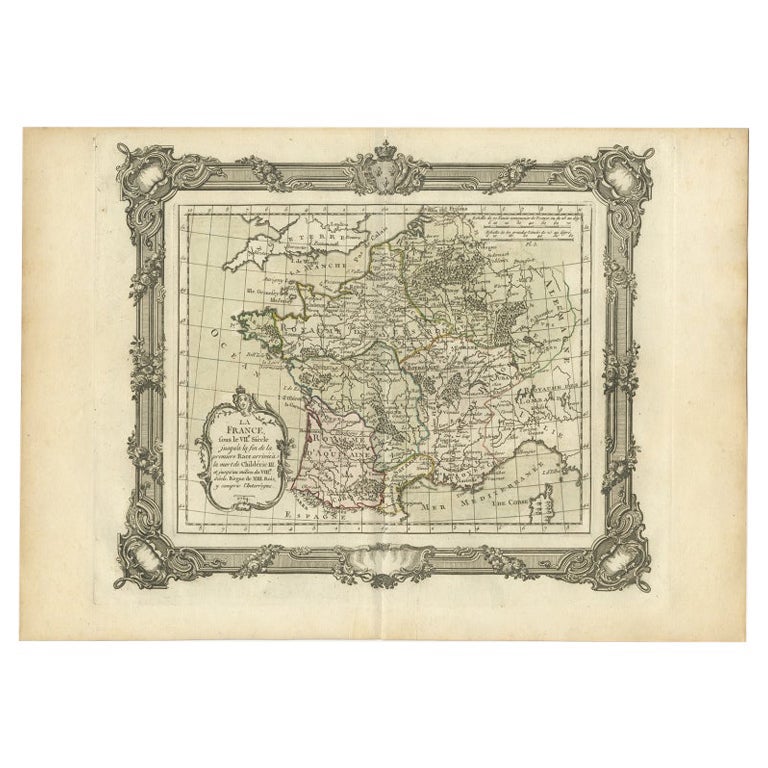
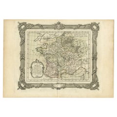
Antique Map of France in the 7th Century by Zannoni, 1765
Located in Langweer, NL
Antique map France titled 'La France sous le VIIe Siècle (..)'. Beautiful old map of France. This map originates from 'Atlas Historique de la France Ancienne et Moderne' by M. Rizzi ...
Category
Antique 18th Century Maps
Materials
Paper
$150 Sale Price
20% Off
Antique Map of France by Janssonius, c.1650
Located in Langweer, NL
Antique map titled 'Gallia Vetus'. Beautiful map of France based on Caesar's De Bello Gallico. In the columns to the left and right important tribes and people are described.
Art...
Category
Antique 17th Century Maps
Materials
Paper
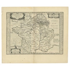
$496 Sale Price
20% Off
Antique Map of Russia in Europe by T. Kitchin, circa 1770
Located in Langweer, NL
Antique map titled 'Russia or Moscovy in Europe, drawn from the latest authorities (..)'. An interesting and attractive early 19th century map of Russia in Europe which was engraved ...
Category
Antique Late 18th Century Maps
Materials
Paper

$151 Sale Price
20% Off
Antique Map of the Region of Saintonge by Janssonius, 1657
By Johannes Janssonius
Located in Langweer, NL
Antique map 'La Saintonge vers le Midy avecq le Brovageais'. Decorative map of the Saintonge region, a former province of France located on the west central Atlantic coast. This map ...
Category
Antique Mid-17th Century Maps
Materials
Paper

$567 Sale Price
20% Off
More Ways To Browse
French Huguenot
Antique Maps Of Maryland
Gambia Antique Map
Antique Manitoba
Antique Map Of Brooklyn
Antique Map Of Michigan
Cham Antiques
Map Of Native American Tribes
Antique Furniture Halifax Furniture
Antique Furniture Trinidad
Antique Kiel Furniture
Cornwall Map
Marie Galante
Patagonia Map
Shepherd And Hedger
Vignola Furniture
Washington Dc Map
Antique Map Of Cornwall