Items Similar to 17th Century Topographical Map, French Champagne Region, Epernay, Iohan Peeters


Want more images or videos?
Request additional images or videos from the seller
1 of 11
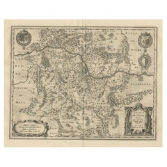
17th Century Topographical Map, French Champagne Region, Epernay, Iohan Peeters
$475
£359.04
€412.60
CA$661.43
A$735.82
CHF 385.73
MX$8,991.53
NOK 4,911.73
SEK 4,623.72
DKK 3,079.92
Shipping
Retrieving quote...The 1stDibs Promise:
Authenticity Guarantee,
Money-Back Guarantee,
24-Hour Cancellation
About the Item
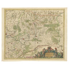
Fine topographical 17th century map by Iohan Peeters of the towns of Epernay and Lametz in the Champagne Region of North Eastern France.
Fabulous period engraving for a Wine Cellar, Bar, Dining Room.
Other similar pieces are available.
Espernay, early spelling of the famed Capital of Champagne, Epernay is depicted surrounded by rolling hills whose famed slopes are now covered with vineyards producing the storied wines the town is known for. The Marne river is identified on the left and three horse riders in 17th century attire, possibly Musketeers, are in the foreground right.
Lametz, a charming municioality in the Champagne-Ardenne region, with a detailed group of travelers at lower left and a figure with his dog on the right headed on the road towards the town. Seiruze, Chauny, Mouzon, Lion, Doul and Stenay are identified in the background.
Fine antique engraving of beautiful detail and workmanship.
In excellent condition commensurate with age.
Size: 15.5 inches by 12.38 inches
Iohan Peeters Delin. Topographia Galliae ... Het tweede deel. Amsterdam : By de Weduw van Ioost Broersz en Casper Meriaen, 1661
- Dimensions:Height: 12.38 in (31.45 cm)Width: 15.5 in (39.37 cm)Depth: 0 in (0 mm)
- Materials and Techniques:
- Place of Origin:
- Period:
- Date of Manufacture:17th Century
- Condition:Wear consistent with age and use.
- Seller Location:New York, NY
- Reference Number:1stDibs: LU5828228731942
About the Seller
5.0
Gold Seller
Premium sellers maintaining a 4.3+ rating and 24-hour response times
1stDibs seller since 2021
57 sales on 1stDibs
Typical response time: 6 hours
- ShippingRetrieving quote...Shipping from: New York, NY
- Return Policy
Authenticity Guarantee
In the unlikely event there’s an issue with an item’s authenticity, contact us within 1 year for a full refund. DetailsMoney-Back Guarantee
If your item is not as described, is damaged in transit, or does not arrive, contact us within 7 days for a full refund. Details24-Hour Cancellation
You have a 24-hour grace period in which to reconsider your purchase, with no questions asked.Vetted Professional Sellers
Our world-class sellers must adhere to strict standards for service and quality, maintaining the integrity of our listings.Price-Match Guarantee
If you find that a seller listed the same item for a lower price elsewhere, we’ll match it.Trusted Global Delivery
Our best-in-class carrier network provides specialized shipping options worldwide, including custom delivery.More From This Seller
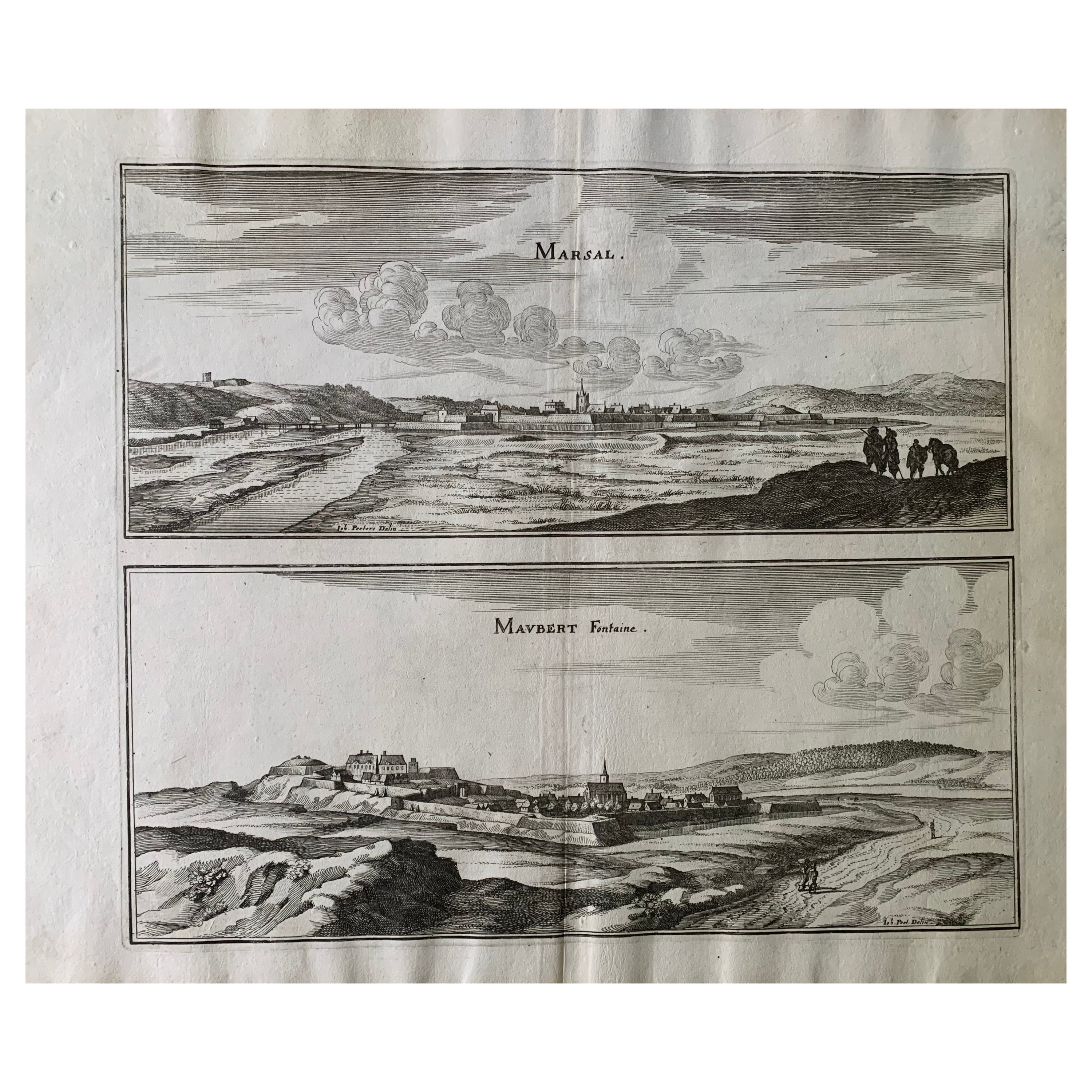
View All17th Century Topographical Map, Champagne-Ardenne, Marsal, Maubert Iohan Peeters
Located in New York, NY
Fine topographical 17th century map by Iohan Peeters of Marsal and Maubert Fontaine in the Champagne-Ardennes Region of North Eastern France.
Fabulous period engraving for a Wine Ce...
Category
Antique 17th Century Dutch Maps
Materials
Paper

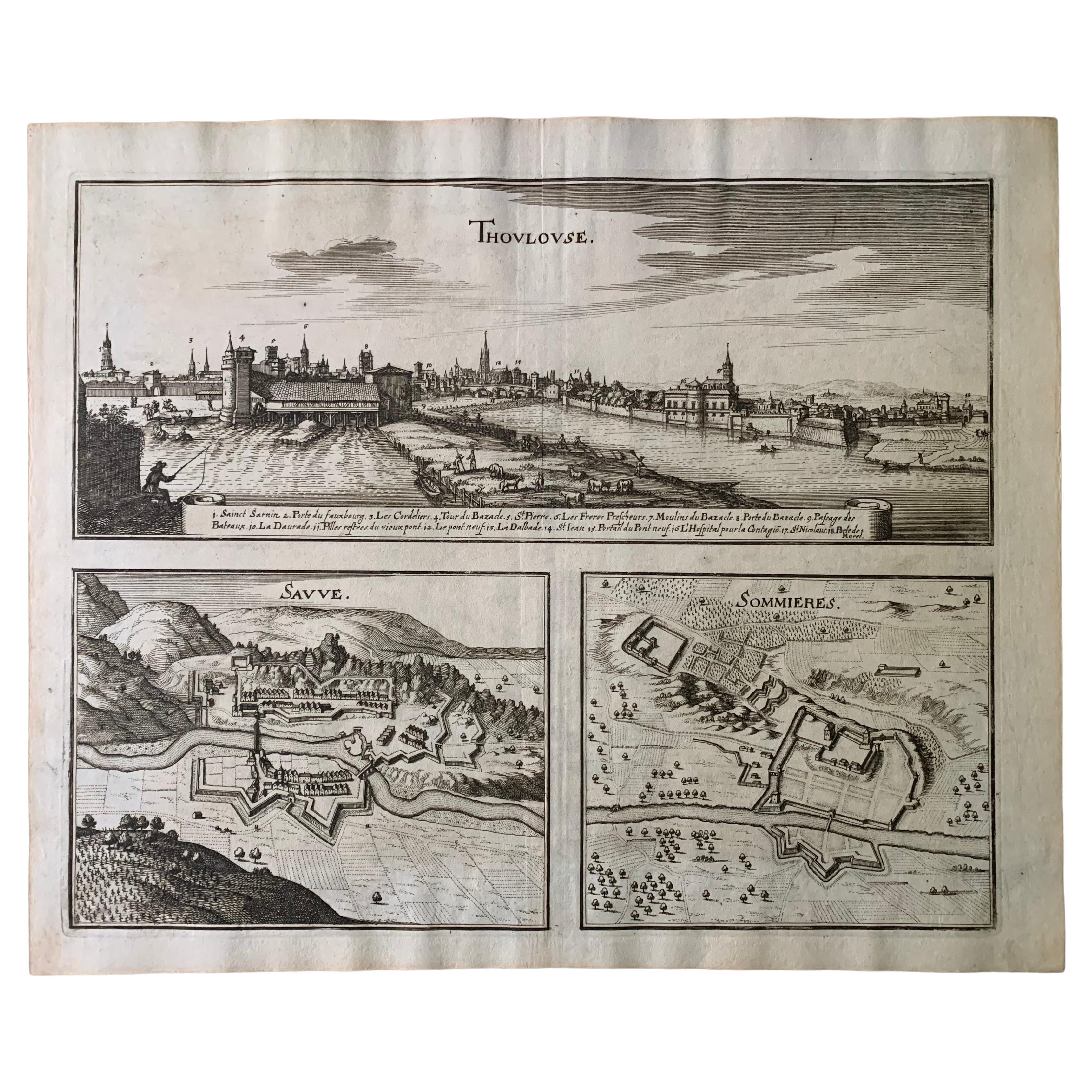
17th Century Toulouse, Savve, Sommieres Topographical Map by Iohan Peeters
Located in New York, NY
Fine topographical 17th century map of Toulouse, Savve and Sommieres by Iohan Peeters
Beautiful engraving of the capital of France's Occitanie Region, Toulouse, called La Ville Rose- the Pink City, for the terracotta bricks used in its many buildings, giving the city a distinct apricot-rose hue. An important cultural and educational center, the city's residents included Nobel Prize winners and world renown artists- Henri de Toulouse-Lautrec, Henri Martin, Jean-Auguste-Dominique Ingres, Antonin Mercie, Alexandre Falguiere and more recently Cyril Kongo...
Category
Antique 17th Century Dutch Maps
Materials
Paper

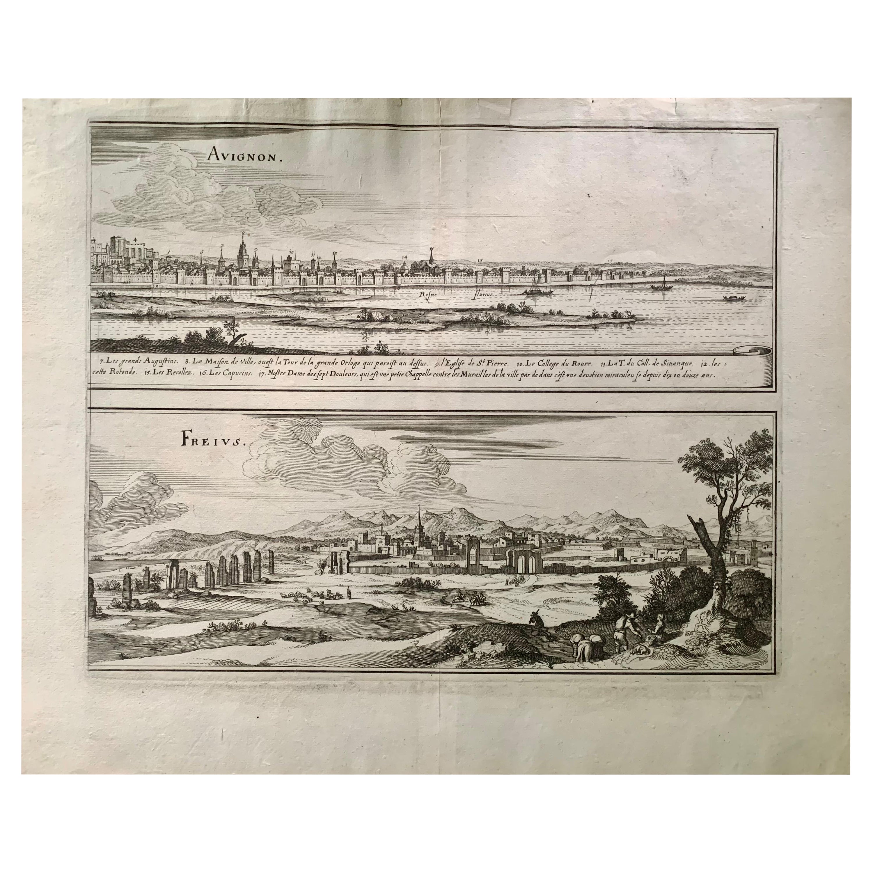
17th Century Topographical Map of Cote D'azur, Avignon, Frejus by Iohan Peeters
Located in New York, NY
Fine topographical 17th century map by Iohan Peeters of the towns of Avignon and Frejus in the Cote d'Azur-Provence-Alpes Region of Southeastern France.
Beautifully suited decorativ...
Category
Antique 17th Century Dutch Maps
Materials
Paper

17th Century Topographical Engraving Nantes & St. Malo, France, by Iohan Peeters
Located in New York, NY
The ancient city of Saint Malo in North Western France has long been associated with adventure on the high seas, piracy and exploration. It was the birthplace of several important in...
Category
Antique 17th Century Dutch Maps
Materials
Paper

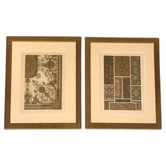
Racinet, Auguste, L'Ornement Polychrome, Paris, Firmin-Didot, Ceiling Designs
By Auguste Racinet
Located in New York, NY
Fine, scarce pair of original chromolithographs of architectural ceiling designs from Racinet's seminal L'Ornement Polychrome published by Firmin-Didot 1869-1873 and 1885-1887. Beaut...
Category
Antique 19th Century French Decorative Art
Materials
Paper
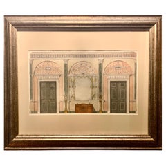
Fine Antique English Watercolor Painting, Adam Style Palace Interior Rendering
Located in New York, NY
A fine antique Adam Style watercolor interior design rendering reminiscent of Osterley Park, London. Dramatic blue-grey and pale salmon tones...
Category
Antique 19th Century British Adam Style Paintings
Materials
Paper
You May Also Like
Antique Map of the Region of Lyon by Hondius, circa 1630
Located in Langweer, NL
Antique map titled 'Lionnois, Forest et Beauiolois'. Old map of the former region of Lyon, Vienne, Bresse, Rohan and the Rhône River. This map originates f...
Category
Antique Mid-17th Century Maps
Materials
Paper

$479 Sale Price
20% Off
Antique Map of the Region of Franche-Comté by Janssonius, circa 1650
Located in Langweer, NL
Antique map titled 'Burgundiae Comitatus Franche Comté'. Old map of the historical and former region of Franche-Comté, France. As a region, it encompasse...
Category
Antique Mid-17th Century Maps
Materials
Paper

$574 Sale Price
20% Off
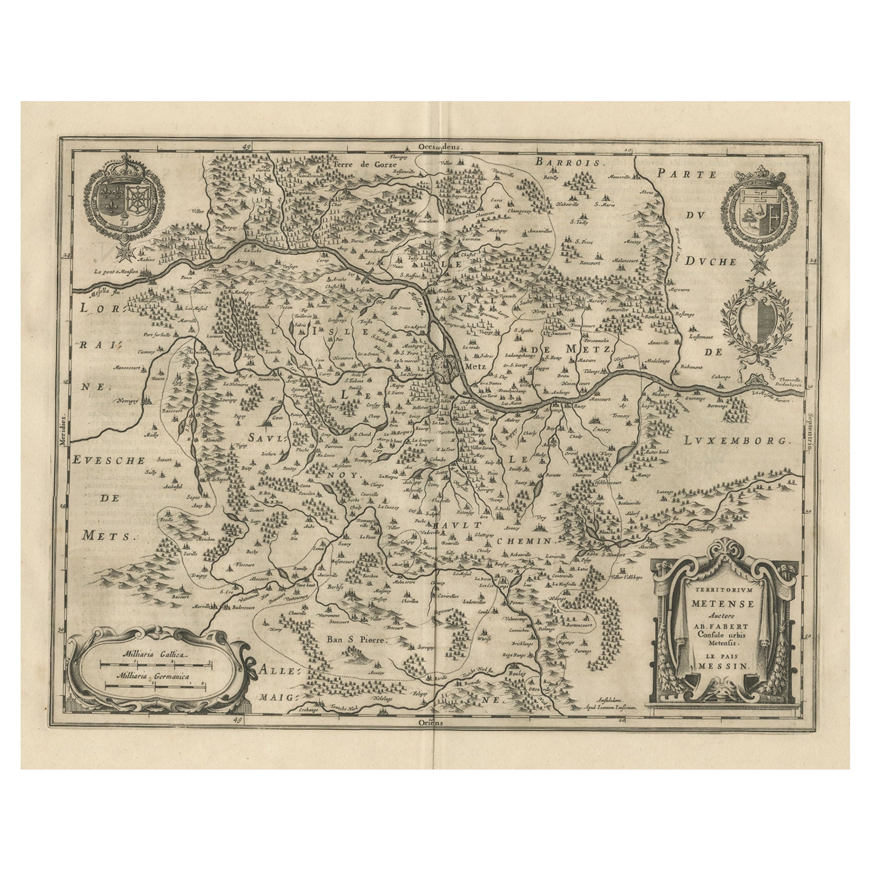
Old Map Focusing on the Wine Region of Metz, the Moselle Region of France, 1657
Located in Langweer, NL
Antique map of France titled 'Territorium Metense'.
Old map focusing on the wine region surrounding Metz, in the Moselle region of France. This map originates from 'Atlas Novus, ...
Category
Antique 1650s Maps
Materials
Paper
$603 Sale Price
20% Off
Antique Map of the Region of Perce and Blois by Janssonius, 1657
By Johannes Janssonius
Located in Langweer, NL
Antique map of France titled 'Perchensis Comitatus - Comitatus Blesensis'. Decorative map of Perce region and the region of Blois. This map originates from 'Atlas Novus, Sive Theatru...
Category
Antique 17th Century Maps
Materials
Paper
$328 Sale Price
20% Off
Antique Map of the Region of Beauvais by Hondius, circa 1630
Located in Langweer, NL
Antique map titled 'Beauvaisis - Comitatus Belovacium'. Old map of the region of Beauvais, France. This map originates from a composite atlas and is signed by J. Hondius.
Category
Antique Mid-17th Century Maps
Materials
Paper

$479 Sale Price
20% Off
Historic 1690 Map of Lorraine in France by Allard - Cities of Toul, Nancy, Metz
Located in Langweer, NL
Exactissima Lotharingia - A Rare 17th Century Map of Lorraine by Carel Allard
This fascinating map of Lorraine, created by Carel Allard around 1690, is a stunning example of coppe...
Category
Antique 1690s Maps
Materials
Paper
$661 Sale Price
20% Off
More Ways To Browse
17th Century Horse
Antique Dog Collectibles
Horse Antiques Collectables
French Wine Map
Wine 17th
Epernay France
Caucasus Map
Map Of Puerto Rico
Nevada Antique Map
Shetland Map
Antique Chicago Maps
Kolkata Antique Furniture
Antique Bermuda Furniture
Antique Dairy Collectibles
Antique Map Of Cuba
Antique Map Of Yorkshire
Antique Map Vietnam
Antique Maps Massachusetts