Items Similar to 18th Century Map of Arabia – Tirion, Amsterdam c.1730


Want more images or videos?
Request additional images or videos from the seller
1 of 10
18th Century Map of Arabia – Tirion, Amsterdam c.1730
$666.28
£498.71
€560
CA$915.15
A$1,023.25
CHF 536.74
MX$12,394.03
NOK 6,775.26
SEK 6,400.99
DKK 4,263.44
About the Item
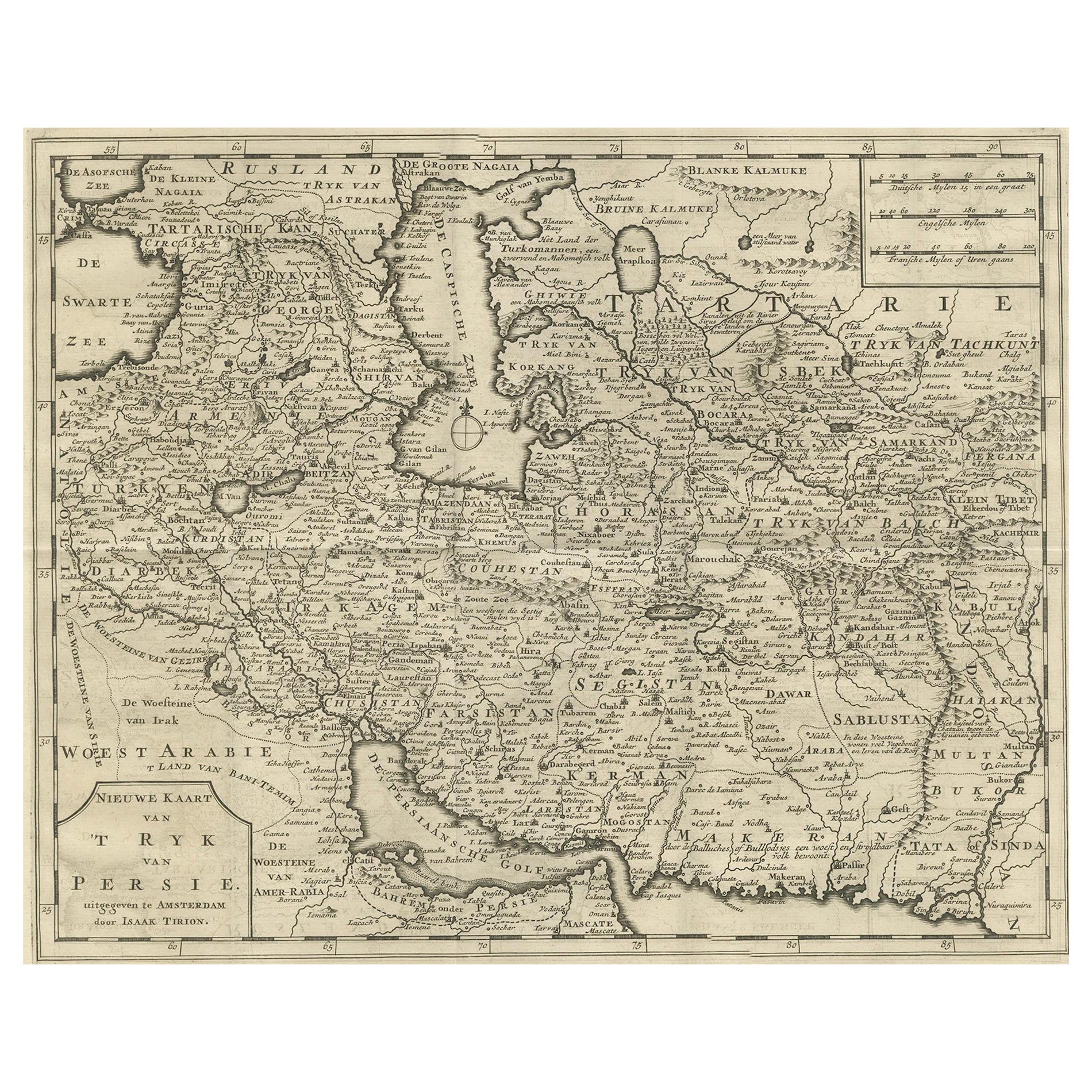
Antique Map of Arabia – Isaak Tirion’s “Nieuwe Kaart van Arabia,” Amsterdam c.1730
This finely detailed 18th-century map, titled “Nieuwe Kaart van Arabia,” was published in Amsterdam by Isaak Tirion around 1730–1750. It presents a comprehensive view of the Arabian Peninsula and its surrounding regions, including the Red Sea, Persian Gulf, and parts of North Africa, Persia, and the Indian Ocean. The map is drawn in Dutch and reflects the European understanding of the region during the Enlightenment period.
The Arabian Peninsula is labeled “Gelukkig Arabia” (Arabia Felix), a classical name denoting the fertile southern parts of the peninsula, including present-day Yemen and Oman. Key cities are marked, such as Mecca (Mekka), Medina (Medinah), Muscat (Muskat), Mocha (Mokka), and Basra (Bassora). The map also shows the lands of Arabia Petraea and Arabia Deserta, with numerous tribal territories, mountain chains, river systems, and coastal features meticulously engraved.
To the northwest, parts of Egypt, Nubia, and the Levant are included, while the southeast borders the East Indies Sea (De Oost Indiësche Zee) and Ethiopia (Abissinia) appears along the southern margin. The map also features routes of trade, including references to caravan travel and maritime commerce—important elements of European interest in the region during the age of exploration and colonial expansion.
Isaak Tirion was a respected Dutch publisher and cartographer known for his clear style and well-engraved maps. His works were widely used for atlases and historical reference during the 18th century. This particular map combines geographic accuracy (as known at the time) with elegant simplicity, making it a highly desirable piece for collectors of antique Middle Eastern or Islamic world cartography.
Condition: Good condition. A strong impression on hand-laid paper with wide margins, except where it was bound in atlas. Vertical and horizontal folds as issued. Slight toning to the sheet and minor edge wear.
Framing tips: This map would look excellent in a black or walnut frame, paired with a warm ivory or parchment-colored mat. A subtle gold inner line or filet can enhance the classical style while drawing attention to the clean engraving.
Technique: Copperplate engraving
Maker: Isaak Tirion, Amsterdam, c. 1730–1750
- Dimensions:Height: 14.18 in (36 cm)Width: 14.97 in (38 cm)Depth: 0.01 in (0.2 mm)
- Materials and Techniques:Paper,Engraved
- Place of Origin:
- Period:
- Date of Manufacture:circa 1730
- Condition:Condition: Good condition. A strong impression on hand-laid paper with wide margins, except where it was bound in atlas. Vertical and horizontal folds as issued. Slight toning to the sheet and minor edge wear.
- Seller Location:Langweer, NL
- Reference Number:Seller: BG-11491-41stDibs: LU3054346152492
About the Seller
5.0
Recognized Seller
These prestigious sellers are industry leaders and represent the highest echelon for item quality and design.
Platinum Seller
Premium sellers with a 4.7+ rating and 24-hour response times
Established in 2009
1stDibs seller since 2017
2,565 sales on 1stDibs
Typical response time: <1 hour
- ShippingRetrieving quote...Shipping from: Langweer, Netherlands
- Return Policy
Authenticity Guarantee
In the unlikely event there’s an issue with an item’s authenticity, contact us within 1 year for a full refund. DetailsMoney-Back Guarantee
If your item is not as described, is damaged in transit, or does not arrive, contact us within 7 days for a full refund. Details24-Hour Cancellation
You have a 24-hour grace period in which to reconsider your purchase, with no questions asked.Vetted Professional Sellers
Our world-class sellers must adhere to strict standards for service and quality, maintaining the integrity of our listings.Price-Match Guarantee
If you find that a seller listed the same item for a lower price elsewhere, we’ll match it.Trusted Global Delivery
Our best-in-class carrier network provides specialized shipping options worldwide, including custom delivery.More From This Seller
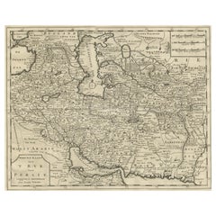
View AllMap of Persia, the Caspian & India – Isaak Tirion, c.1730
Located in Langweer, NL
Map of Persia and Surrounding Regions – “Nieuwe Kaart van 't Ryck van Persie” by Isaak Tirion, Amsterdam, c. 1730
This finely detailed copperplate map titled “Nieuwe Kaart van 't Ry...
Category
Antique Mid-18th Century Dutch Maps
Materials
Paper
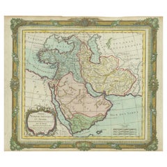
Antique Map of the Arabian Peninsula by Bonne 'c.1780'
Located in Langweer, NL
Antique map titled 'Carte de l'Arabie, du Golfe Persique, et de la Mer Rouge (..)'. Original antique map of the Arabian Peninsula, including the horn...
Category
Antique Late 18th Century Maps
Materials
Paper

$523 Sale Price
20% Off
Antique Map of the Arabian Peninsula by Bonne 'c.1780'
Located in Langweer, NL
Antique map titled 'Carte de l'Arabie, du Golfe Persique, et de la Mer Rouge (..)'. Original antique map of the Arabian Peninsula, including the horn...
Category
Antique Late 18th Century Maps
Materials
Paper

$475 Sale Price
20% Off
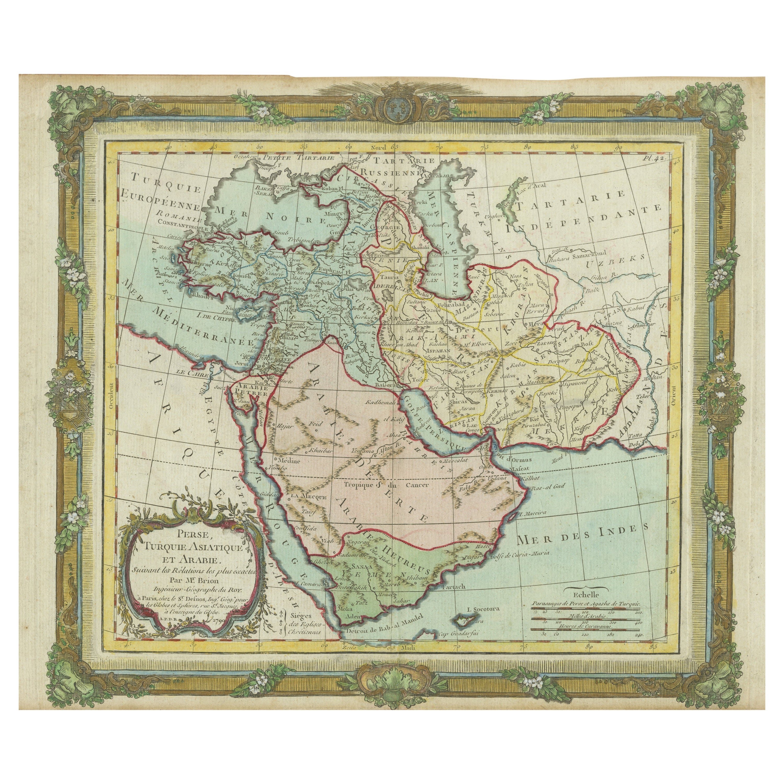
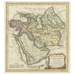
Antique Map of the Middle East with a Large Arabia, 1799
Located in Langweer, NL
Antique map titled 'Perse, Turquie Asiatique et Arabie (..)'. Map of the Middle East with a large Arabia, extending from the Black Sea to the In...
Category
Antique Late 18th Century Maps
Materials
Paper
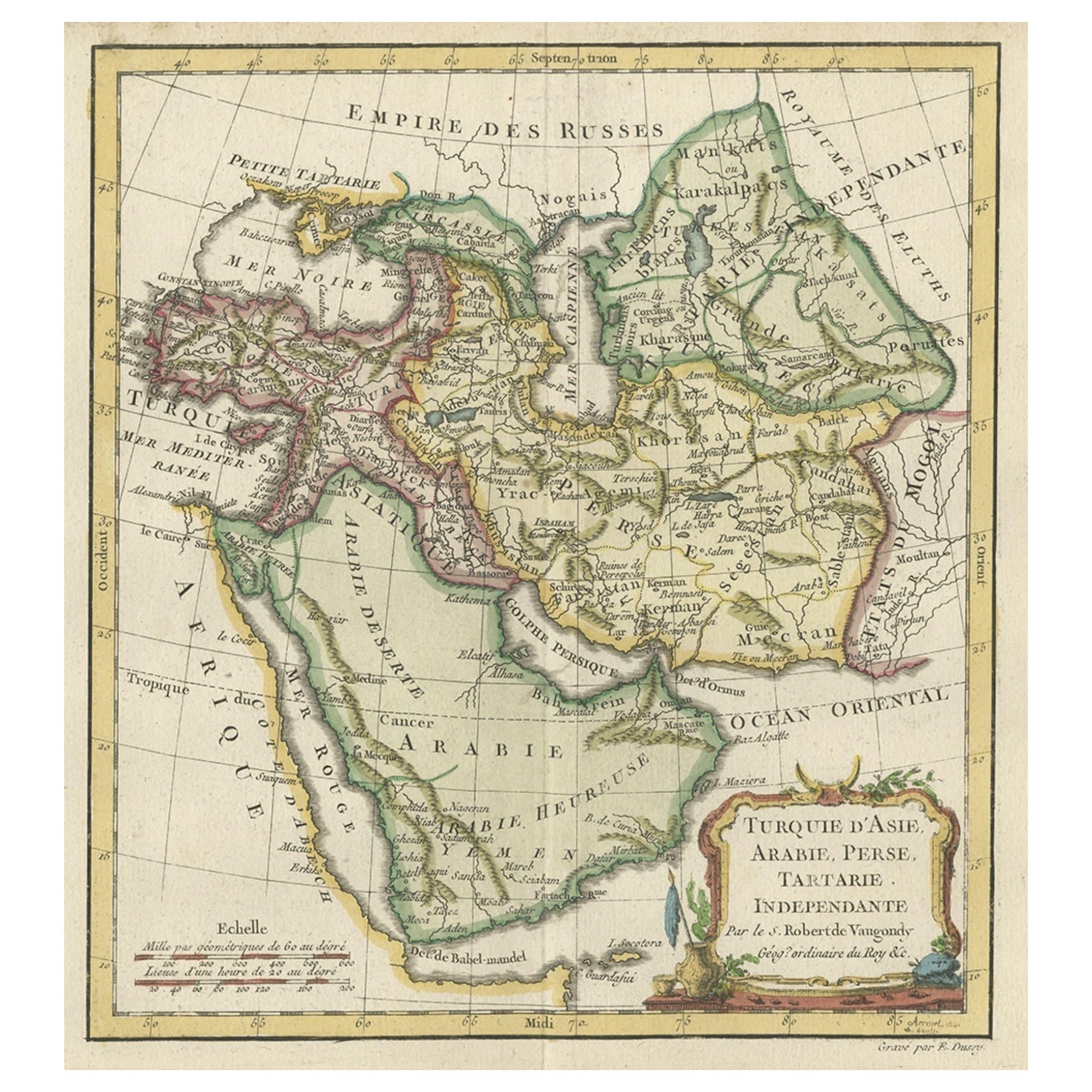
Old Map Depicting Turkey, Persia, Arab and Black Sea Etc, 1778
Located in Langweer, NL
Antique map titled 'Turquie d'Asie, Arabie, Perse, Tartarie Independante'.
Old map of Turkey in Asia. The map shows all of Turkey and the Black Sea, and extends east to include t...
Category
Antique 1770s Maps
Materials
Paper
$513 Sale Price
20% Off
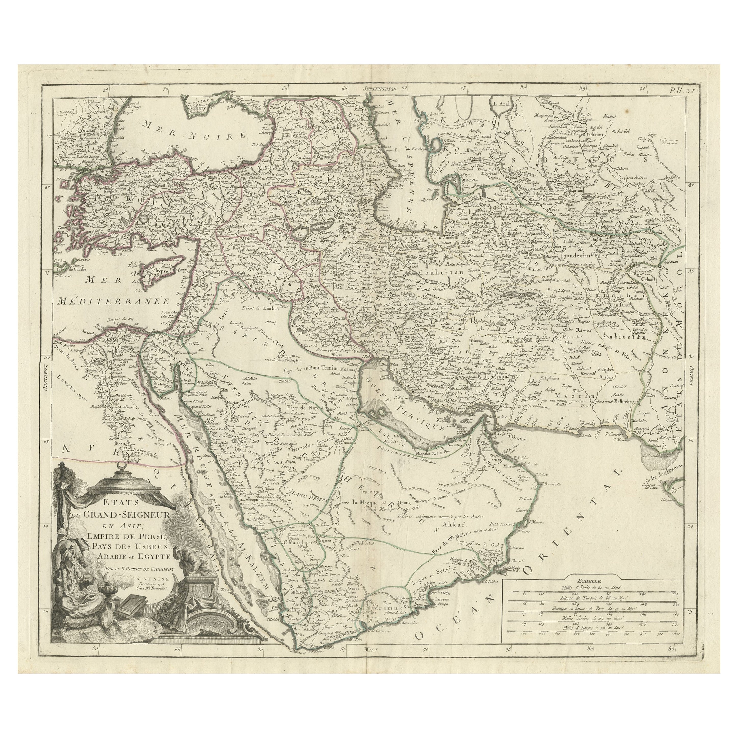
Detailed Original Antique Map of the Turkish Empire with Arabia, 1778
Located in Langweer, NL
Title: Etats Due Grand-Seigneur En Asie, Empire De Perse, Pays Des Usbecs, Arabie et Egypte . . . 1753
Detailed map of the Turkish Empire, extending to the Black Sea, Georgia, the...
Category
Antique 1770s Maps
Materials
Paper

$456 Sale Price
20% Off
You May Also Like
Persia, Armenia & Adjacent Regions: A Hand-colored 17th Century Map by De Wit
By Frederick de Wit
Located in Alamo, CA
This colorful and detailed 17th century copperplate map by Frederick De Wit was published in Amsterdam between 1666 and 1690. It depicts the Caspian Se...
Category
Late 17th Century Old Masters More Prints
Materials
Engraving

Map of the East Indies: An Original 18th Century Hand-colored Map by E. Bowen
Located in Alamo, CA
This is an original 18th century hand-colored map entitled "An Accurate Map of the East Indies Exhibiting the Course of the European Trade both on the Continent and Islands" by Emanu...
Category
Mid-18th Century Old Masters Landscape Prints
Materials
Engraving

1718 Ides & Witsen Map "Route D'amsterdam a Moscow Et De La Ispahan Et Gamron
Located in Norton, MA
1718 Ides & Witsen map, entitled
"Route D'Amsterdam A Moscow Et De La Ispahan Et Gamron,"
Ric.b005
Subject: Eastern Europe and Central Asia
Period: 1718 (published)
Publicati...
Category
Antique Early 18th Century Dutch Maps
Materials
Paper

Map of Mar Del Nort - Etching by Johannes Janssonius - 1650s
By Johannes Janssonius
Located in Roma, IT
Antique Map -Mar Del Nort is an antique map realized in 1650 by Johannes Janssonius (1588-1664).
The Map is Hand-colored etching, with coeval watercolorang.
Good conditions with sl...
Category
1650s Modern Figurative Prints
Materials
Etching

Persiae, Armeniae, Natoliae et Arabiae Descriptio per Frederick deWit 1666 map
Located in Paonia, CO
Map of Persiae, Armeniae, Natoliae et Arabiae Descriptio per F de Wit 1688 engraving from: Atlas Contractus Orbis Terrarum Praecipuas ac Novissimas Complectens Tabulas. Amsterdam, N. Visscher, 1656-77. (Koeman III, Vis5-8) This highly decorative map of the Middle East is by the Dutch engraver, publisher, and map seller...
Category
1660s Realist Landscape Prints
Materials
Engraving

Antique Map - Mar Di Athiopia - Etching by Johannes Janssonius - 1650s
By Johannes Janssonius
Located in Roma, IT
Antique Map - Mar Di Athiopia is an antique map realized in 1650 by Johannes Janssonius (1588-1664).
The Map is Hand-colored etching, with coeval watercolorang.
Good conditions wit...
Category
1650s Modern Figurative Prints
Materials
Etching
