Items Similar to Antique Map of the Middle East with a Large Arabia, 1799


Want more images or videos?
Request additional images or videos from the seller
1 of 6
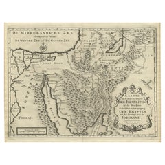
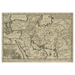
Antique Map of the Middle East with a Large Arabia, 1799
About the Item
Antique map titled 'Perse, Turquie Asiatique et Arabie (..)'. Map of the Middle East with a large Arabia, extending from the Black Sea to the Indian Ocean and from the Red Sea to Persia and Iraq. Small but decorative cartouche and a very elaborate border. Published 1799.
- Dimensions:Height: 11.03 in (28 cm)Width: 15.63 in (39.7 cm)Depth: 0.02 in (0.5 mm)
- Materials and Techniques:Paper,Engraved
- Period:
- Date of Manufacture:1799
- Condition:General age-related toning. Original folding line. Minor wear and soiling, blank verso. Please study image carefully.
- Seller Location:Langweer, NL
- Reference Number:
About the Seller
5.0
Platinum Seller
These expertly vetted sellers are 1stDibs' most experienced sellers and are rated highest by our customers.
Established in 2009
1stDibs seller since 2017
1,929 sales on 1stDibs
Typical response time: <1 hour
- ShippingRetrieving quote...Ships From: Langweer, Netherlands
- Return PolicyA return for this item may be initiated within 14 days of delivery.
More From This SellerView All
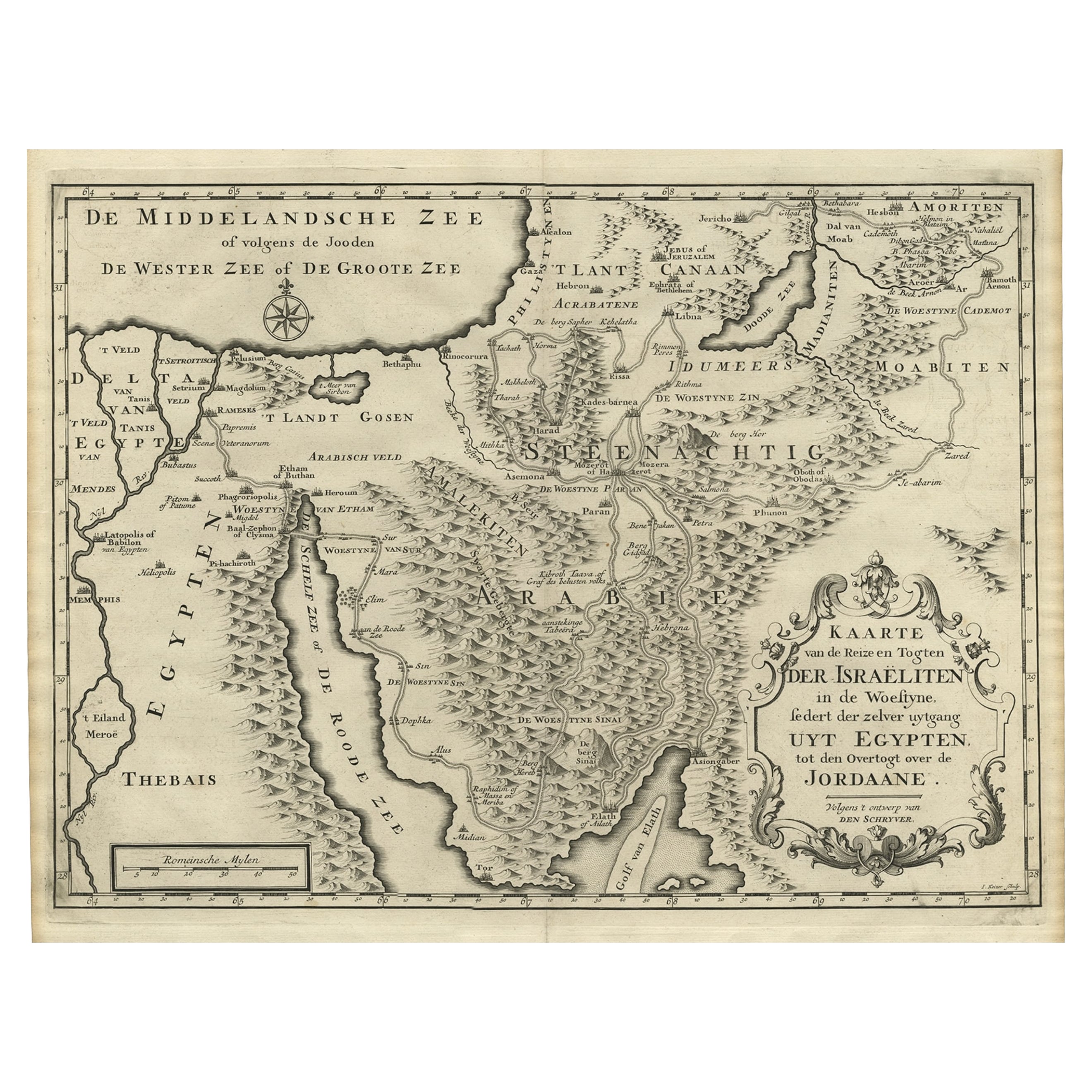
- Scarce Middle East and Arabia Map Showing The Exodus of the Israelites, 1725Located in Langweer, NLAntique map titled 'Kaarte van de reize en togten der Israeliten in de woestyne, sedert der zelver uytgang uyt Egypten, tot den overtogt over de Jordaane.' Scarce map of the Middle East and Arbabia. It shows the exodus...Category
Antique 1720s Maps
MaterialsPaper
- Rare Antique Map of the Middle East, ca.1690Located in Langweer, NLDescription: Antique print, untitled. Two decorative maps on one sheet of the middle east in biblical times. Source unknown, to be determined. Artists and Engravers: Anonymous...Category
Antique 1690s Prints
MaterialsPaper
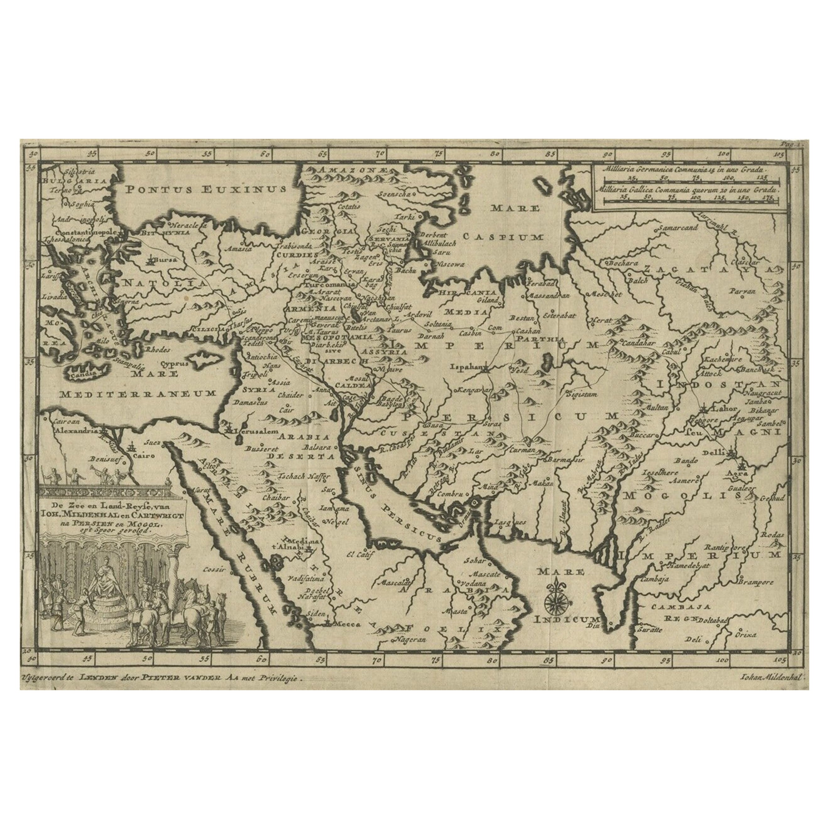
- Old Engraved Map of the Middle East, Arabia and Part of Greece 'Cyprus', 1706Located in Langweer, NLTitle: Antique map titled 'De Zee en Land-Reyse, van Ioh. Mildenhal en Cartwrigt na Persien en Mogol, opt spoor gevolgd'. Old map of the Middle East, also depicting part of Greece ...Category
Antique Early 1700s Maps
MaterialsPaper
- Antique Bible Map of the Middle East by A. Schut, 1743Located in Langweer, NLAntique map titled 'De Gelegentheyt van 't Paradys en 't Landt Canaan'. Dutch Bible map covering the region between the Mediterranean and the Persian Gulf, ...Category
Antique Mid-18th Century Maps
MaterialsPaper
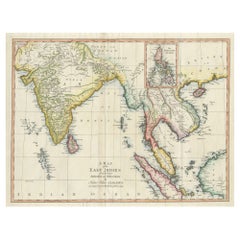
- Large Antique Map of the East Indies, with Inset of the PhilippinesLocated in Langweer, NLAntique map titled 'A Map of the East Indies (..)'. Large antique map of Southeast Asia, India, and part of China, extending to Tibet, the Maladives, Sumatra, part of Borneo, Hainan,...Category
Antique Late 18th Century Maps
MaterialsPaper
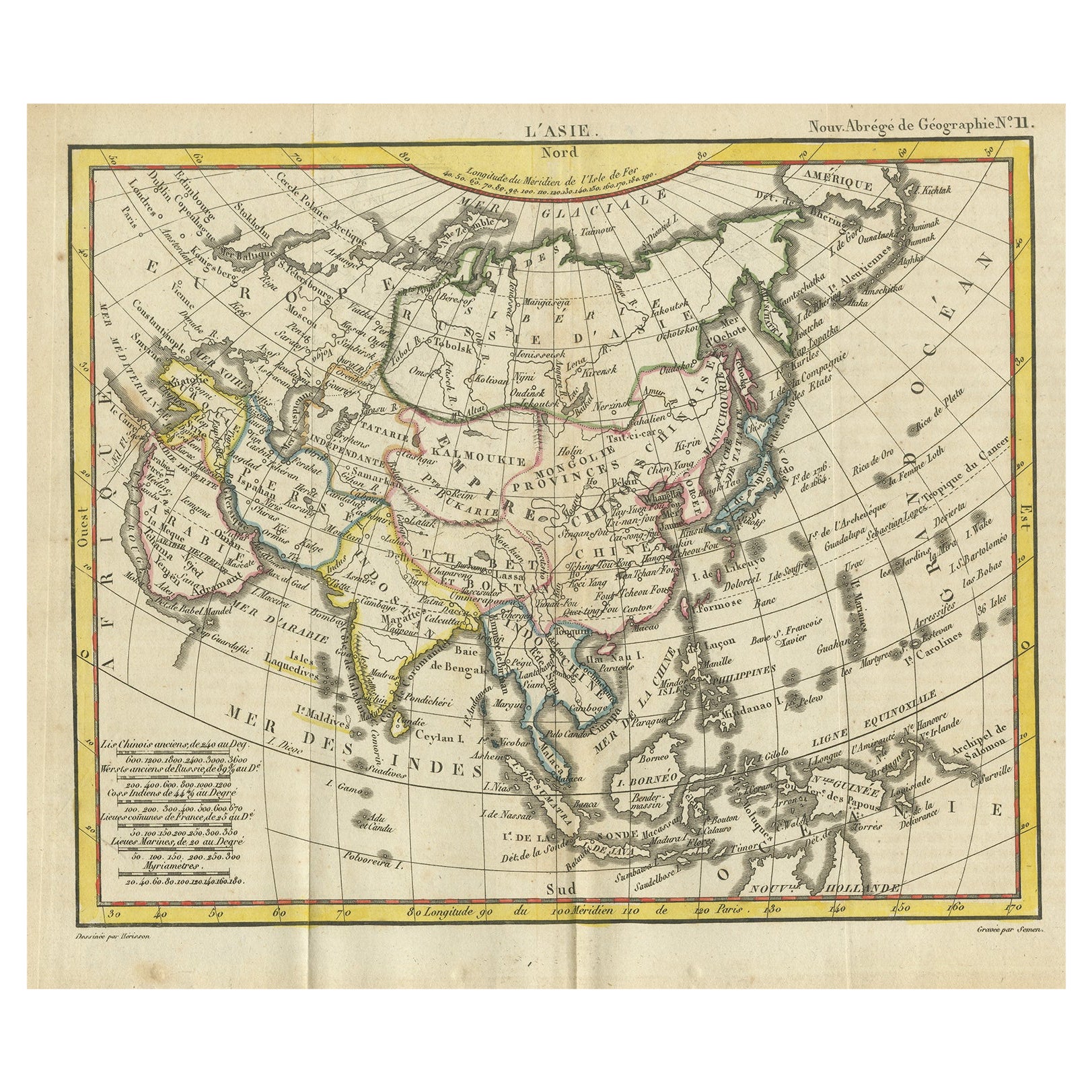
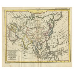
- Antique Map of Asia from the Middle East to the Coast of Alaska, 1816Located in Langweer, NLAntique map titled ‘L’Asie‘. This is an original antique map of Asia, by Hérisson, taken from atlas ""Nouv. Abrége de Géographie"". An engraved map with coloring of Asia from the Mid...Category
Antique 19th Century Maps
MaterialsPaper


You May Also Like
- Original Antique Map of South East Asia, Arrowsmith, 1820Located in St Annes, LancashireGreat map of South East Asia Drawn under the direction of Arrowsmith Copper-plate engraving Published by Longman, Hurst, Rees, Orme and Brown, 1820 Unframed.Category
Antique 1820s English Maps
MaterialsPaper
- Original Antique Map of South East Asia by Thomas Clerk, 1817Located in St Annes, LancashireGreat map of South East Asia Copper-plate engraving Drawn and engraved by Thomas Clerk, Edinburgh. Published by Mackenzie And Dent, 1817 Unframed.Category
Antique 1810s English Maps
MaterialsPaper
- Original Antique Map of South East Asia by Becker, circa 1840Located in St Annes, LancashireGreat map of South East Asia Steel engraving with original color outline Engraved by Becker Published by Virtue, circa 1840. Unframed.Category
Antique 1840s English Other Maps
MaterialsPaper
- Large Antique 1859 Map of North AmericaLocated in Sag Harbor, NYThis Map was made by Augustus Mitchell in 1859 It is in amazing condition for being 163 years old. This price is for the rolled up easy to ship version of this piece. I will be Frami...Category
Antique Mid-19th Century American Maps
MaterialsCanvas, Paper

- Original Antique English County Map, East Yorkshire, J & C Walker, 1851Located in St Annes, LancashireGreat map of The East Riding of Yorkshire Original colour By J & C Walker Published by Longman, Rees, Orme, Brown & Co. 1851 Unframed.Category
Antique 1850s English Other Maps
MaterialsPaper
- Middle East Saudia Arabia Israel India Map Rollable Mural Vintage Wall ChartLocated in Berghuelen, DEThe pull-down school map is depicting the region of the Middle East (Turkey, Israel, Egypt, Saudi Arabia, Irak, Iran etc.) and India, Himalaya. Used as teaching material in German sc...Category
Late 20th Century German Country Prints
MaterialsCanvas, Wood, Paper


