Items Similar to Antique Bible Plan of Jerusalem by Covens & Mortier, 1743
Want more images or videos?
Request additional images or videos from the seller
1 of 9
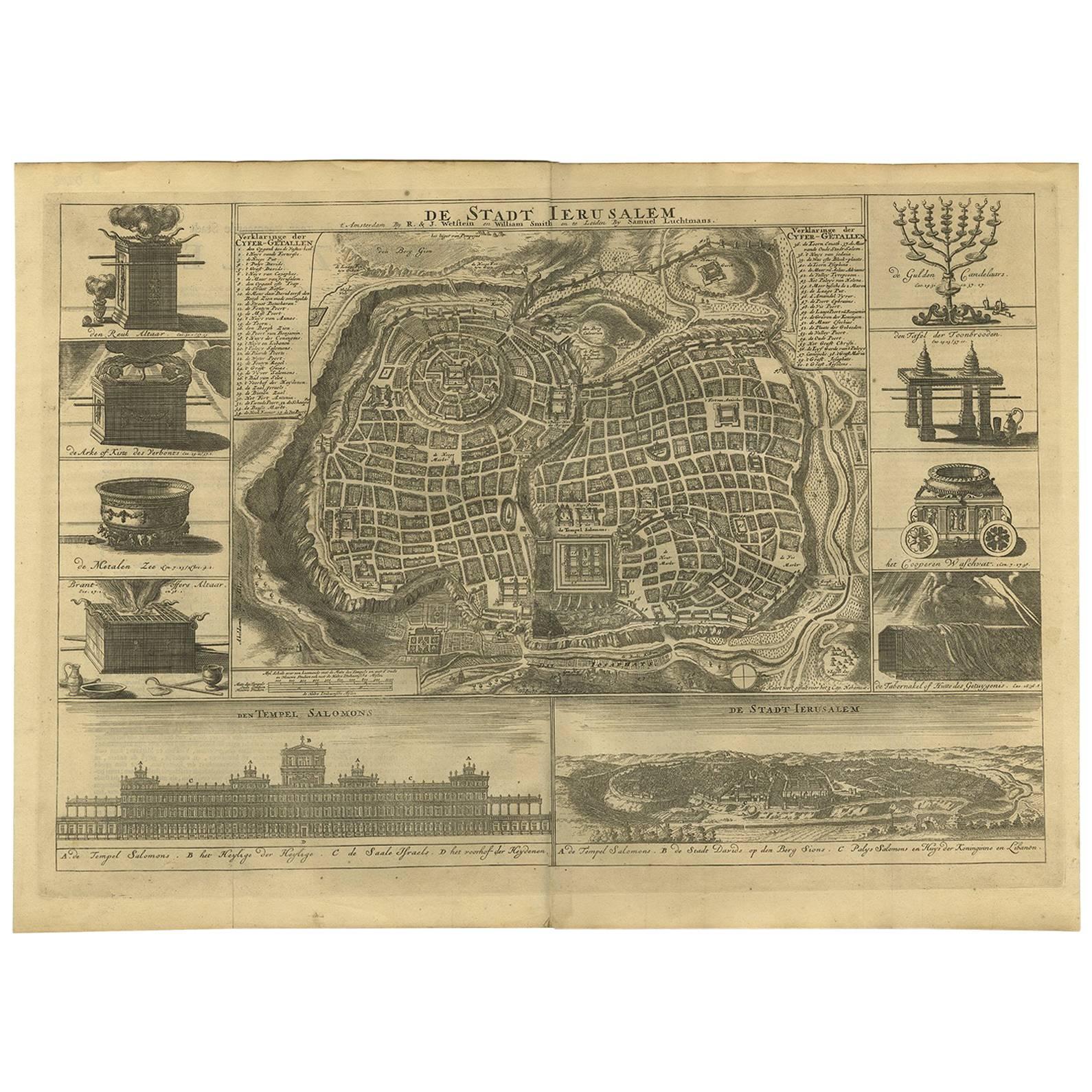
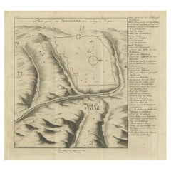
Antique Bible Plan of Jerusalem by Covens & Mortier, 1743
$519.84
$649.8020% Off
£389.65
£487.0620% Off
€440
€55020% Off
CA$714.17
CA$892.7120% Off
A$797.30
A$996.6320% Off
CHF 417.78
CHF 522.2220% Off
MX$9,759.79
MX$12,199.7320% Off
NOK 5,305.75
NOK 6,632.1920% Off
SEK 5,002.65
SEK 6,253.3120% Off
DKK 3,349.44
DKK 4,186.8020% Off
Shipping
Retrieving quote...The 1stDibs Promise:
Authenticity Guarantee,
Money-Back Guarantee,
24-Hour Cancellation
About the Item
This plan originates from ‘Biblia Sacra, dat is, de H. Schriftuer van het Oude, en het Nieuwe Testament, naer de laetste Roomsche keure der gemeine Latijnsche overzettinge, in nederduitsch vertaeld (...)’ Utrecht, Hermanus Besseling, 1743.
- Dimensions:Height: 15.44 in (39.2 cm)Width: 17.72 in (45 cm)Depth: 0.02 in (0.5 mm)
- Materials and Techniques:
- Period:
- Date of Manufacture:1743
- Condition:Please study image carefully.
- Seller Location:Langweer, NL
- Reference Number:Seller: BG-024971stDibs: LU305439328171
About the Seller
5.0
Recognized Seller
These prestigious sellers are industry leaders and represent the highest echelon for item quality and design.
Platinum Seller
Premium sellers with a 4.7+ rating and 24-hour response times
Established in 2009
1stDibs seller since 2017
2,511 sales on 1stDibs
Typical response time: <1 hour
- ShippingRetrieving quote...Shipping from: Langweer, Netherlands
- Return Policy
Authenticity Guarantee
In the unlikely event there’s an issue with an item’s authenticity, contact us within 1 year for a full refund. DetailsMoney-Back Guarantee
If your item is not as described, is damaged in transit, or does not arrive, contact us within 7 days for a full refund. Details24-Hour Cancellation
You have a 24-hour grace period in which to reconsider your purchase, with no questions asked.Vetted Professional Sellers
Our world-class sellers must adhere to strict standards for service and quality, maintaining the integrity of our listings.Price-Match Guarantee
If you find that a seller listed the same item for a lower price elsewhere, we’ll match it.Trusted Global Delivery
Our best-in-class carrier network provides specialized shipping options worldwide, including custom delivery.More From This Seller
View AllAntique Bible Plan of Ancient Jerusalem, 1743
Located in Langweer, NL
This plan originates from ‘Biblia Sacra, dat is, de H. Schriftuer van het Oude, en het Nieuwe Testament, naer de laetste Roomsche keure der gemeine Latijnsche overzettinge, in nederd...
Category
Antique Mid-18th Century Maps
Materials
Paper

$819 Sale Price
36% Off
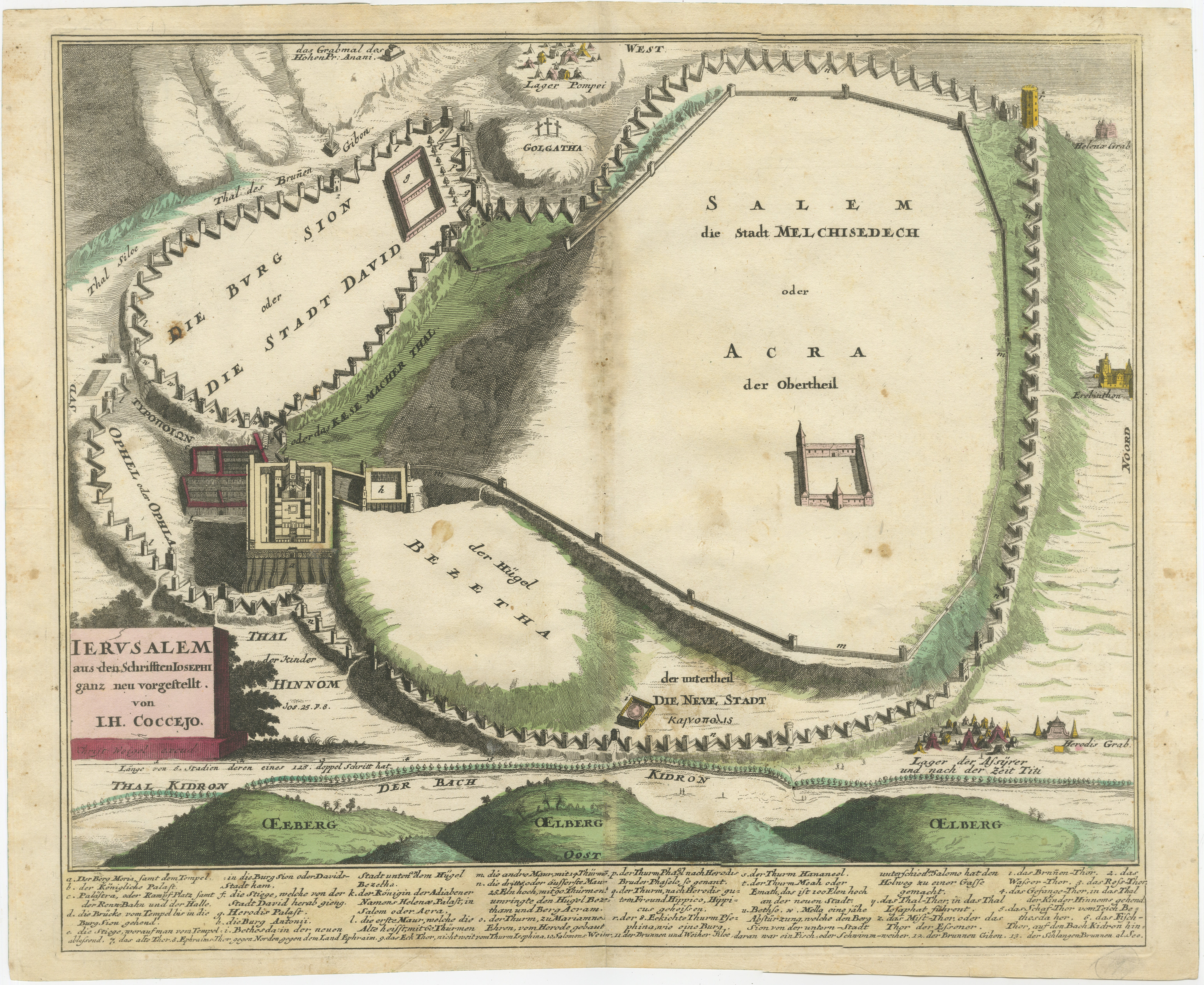
Original Antique Map of Jerusalem Based on Josephus' Writings by Weigel, ca.1720
Located in Langweer, NL
1720 Weigel Map of Jerusalem Based on Josephus' Writings
This intricate 1720 bird's-eye view map of ancient Jerusalem by I.H. Coccejo, engraved by Christoph Weigel, offers a fasc...
Category
Antique 1720s Maps
Materials
Paper

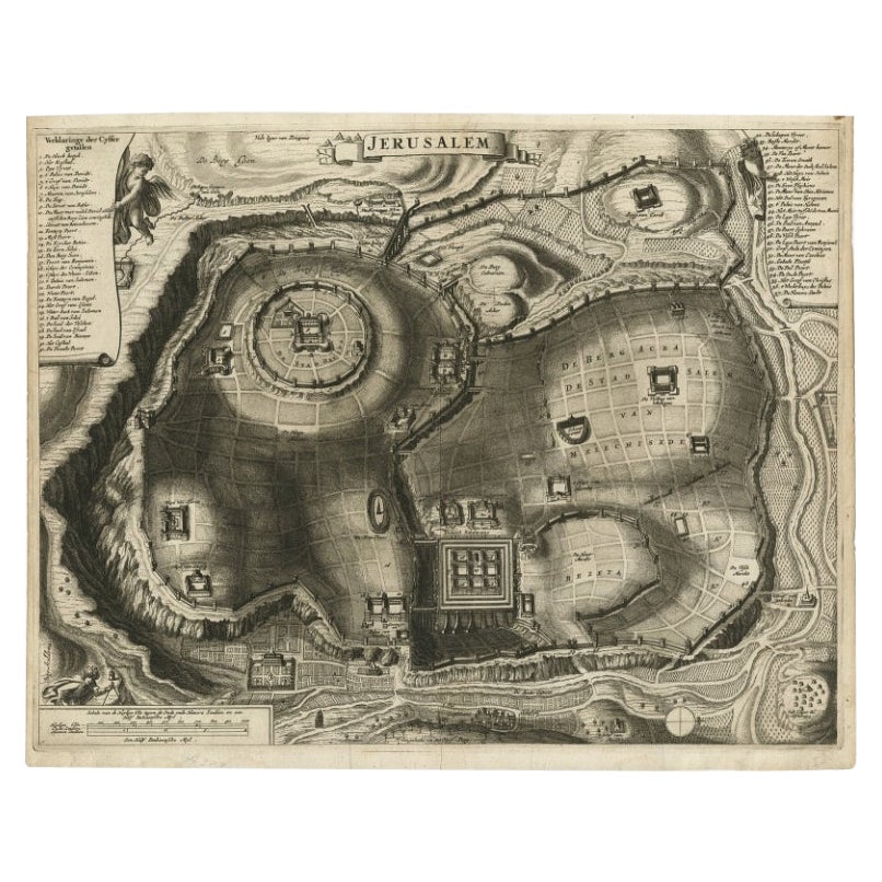
Antique Detailed Map of Jerusalem in Israël with Extensive Key and Scale, 1698
Located in Langweer, NL
Antique map titled 'Jerusalem.'
Plan of the ancient city of Jerusalem. With extensive key and scale. Source unknown, to be determined.
Artists and Engravers: Made by 'Cornelis de...
Category
Antique 17th Century Maps
Materials
Paper

$614 Sale Price
20% Off
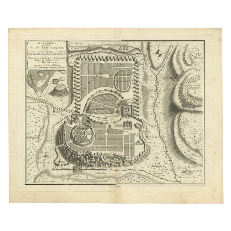
Bird's-Eye Plan of Jerusalem in Israël, a Rare Original Engraving, 1750
Located in Langweer, NL
Antique map titled 'De VIIde Landkaart Verbeeldende de Stad Jerusalem Beneven de daar Omgelegen Bergen en Dalen (..).'
Bird's-eye plan of Jerusalem in Israel. This map shows the mo...
Category
Antique 18th Century Maps
Materials
Paper
$708 Sale Price
20% Off
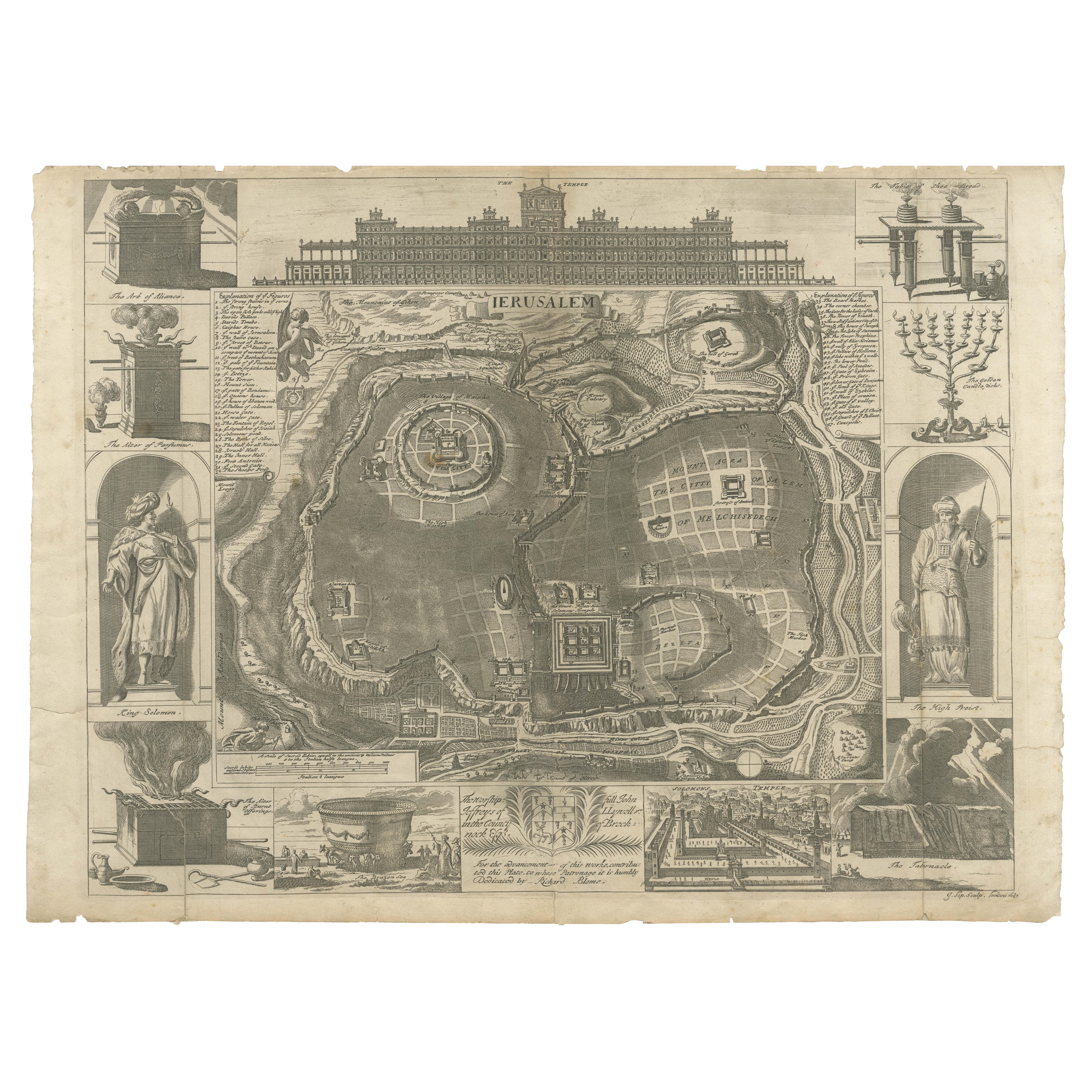
Jerusalem and Temple Imaginary Map by Blome, Published London 1689
Located in Langweer, NL
Imaginary Plan of Jerusalem by Blome after Villalpando, 1689
This impressive antique engraving presents an imaginary plan of Jerusalem by Richard Blome, published in 1689. The engra...
Category
Antique Late 17th Century English Maps
Materials
Paper
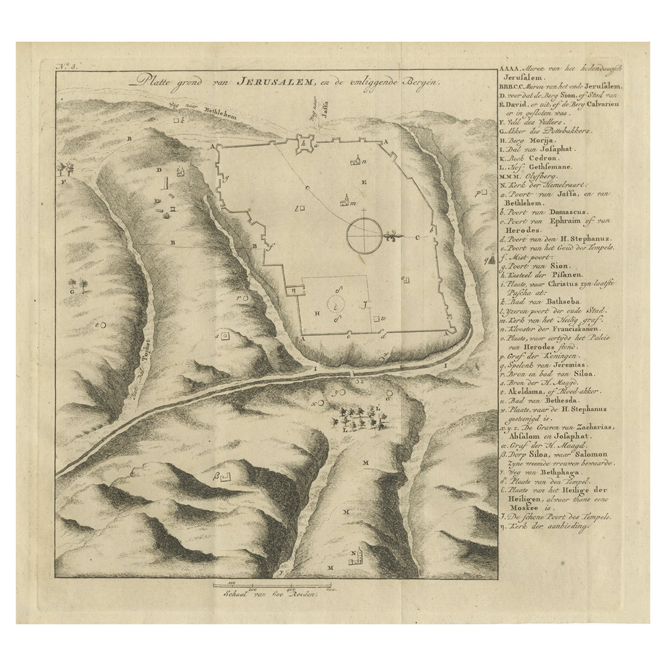
Antique Engraving of a Map or Plan of Jerusalem and Surrounding Mountains, 1773
Located in Langweer, NL
Antique map titled 'Platte grond van Jerusalem, en de omliggende Bergen'. Plan of the city of Jerusalem, with surrounding mountains. Originates from the first Dutch editon of an inte...
Category
Antique 18th Century Maps
Materials
Paper
$255 Sale Price
20% Off
You May Also Like
17th-18th Century Siege of Graves Mapping Engraving By Willian III
Located in Kingston, NY
RARE French 17th-18th Century Enhanced Siege of Graves Mapping Engraving BY William III, also widely known as William of Orange,
The Siege of Grave in Dutch Brabant started by Monsie...
Category
Antique 17th Century French Prints
Materials
Paper

1657 Janssonius Map of Vermandois and Cappelle, Ric. A-004
Located in Norton, MA
1657 Janssonius map of
Vermandois and Cappelle
Ric.a004
Description: Antique map of France titled 'Descriptio Veromanduorum - Gouvernement de la Cappelle'. Two detailed maps o...
Category
Antique 17th Century Unknown Maps
Materials
Paper

1714 Henri Chatelain "Nouvelle Carte Des Etatas Du Grand.Duc De Mos Moscovie Eur
Located in Norton, MA
A 1714 Henri Chatelain map, entitled
"Nouvelle Carte Des Etatas Du Grand Duc De Moscovie En Europe,"
Ricb001
Henri Abraham Chatelain (1684-1743) was a Huguenot pastor of Parisi...
Category
Antique Early 18th Century Dutch Maps
Materials
Paper

1633 Map "La Souverainete De Sedan Et De Raucourt, Et La Prevoste Ric0011
Located in Norton, MA
1653 map entitled
"La Souverainete de Sedan et de Raucourt, et la Prevoste de Doncheri,"
Ric0011
Description:
Lovely map centered on Sedan and Doncheri and the Meuze River fr...
Category
Antique 17th Century Dutch Maps
Materials
Paper

17th Century Toulouse, Savve, Sommieres Topographical Map by Iohan Peeters
Located in New York, NY
Fine topographical 17th century map of Toulouse, Savve and Sommieres by Iohan Peeters
Beautiful engraving of the capital of France's Occitanie Region, Toulouse, called La Ville Rose- the Pink City, for the terracotta bricks used in its many buildings, giving the city a distinct apricot-rose hue. An important cultural and educational center, the city's residents included Nobel Prize winners and world renown artists- Henri de Toulouse-Lautrec, Henri Martin, Jean-Auguste-Dominique Ingres, Antonin Mercie, Alexandre Falguiere and more recently Cyril Kongo...
Category
Antique 17th Century Dutch Maps
Materials
Paper

17th Century Topographical Map of Cote D'azur, Avignon, Frejus by Iohan Peeters
Located in New York, NY
Fine topographical 17th century map by Iohan Peeters of the towns of Avignon and Frejus in the Cote d'Azur-Provence-Alpes Region of Southeastern France.
Beautifully suited decorativ...
Category
Antique 17th Century Dutch Maps
Materials
Paper

More Ways To Browse
Jerusalem Furniture
18th Century Bible
Japanese Silver Ceramics
One Of A Kind Chair
Used Oak Dining Room Chairs
Childrens Vintage Poster
Vintage Travel Poster Mid Century
Desk Key
Carved Cabriole Table
Dark Antique Table
White Wooden Table
Antique Wall Table
1960 Chair Wood Danish
Unusual Dining Table
Antique Dutch Plates
Mdf Table
Showcase Coffee Table
Space Age Orange