Items Similar to Antique Map of Aceh or Adjeh in Northern Sumatra, Indonesia, 1900


Want more images or videos?
Request additional images or videos from the seller
1 of 5
Antique Map of Aceh or Adjeh in Northern Sumatra, Indonesia, 1900
$347.76
£258.70
€290
CA$476.20
A$529.48
CHF 276.46
MX$6,445
NOK 3,527.54
SEK 3,305.14
DKK 2,207.61
Shipping
Retrieving quote...The 1stDibs Promise:
Authenticity Guarantee,
Money-Back Guarantee,
24-Hour Cancellation
About the Item
Antique map of Aceh, Sumatra. This map originates from 'Atlas van Nederlandsch Oost- en West-Indië' by I. Dornseiffen.
Artists and Engravers: Published by Seyffardt's Boekhandel, Amsterdam.
Condition: Very good, general age-related toning. Please study image carefully.
Date: 1900
Overall size: 52.2 x 38.9 cm.
Image size: 045.2 x 35.7 cm.
- Dimensions:Height: 15.32 in (38.9 cm)Width: 20.56 in (52.2 cm)Depth: 0 in (0.01 mm)
- Materials and Techniques:
- Period:
- Date of Manufacture:1900
- Condition:Condition: Very good, general age-related toning. Please study image carefully.
- Seller Location:Langweer, NL
- Reference Number:Seller: BG-06669-151stDibs: LU3054325991762
About the Seller
5.0
Recognized Seller
These prestigious sellers are industry leaders and represent the highest echelon for item quality and design.
Platinum Seller
Premium sellers with a 4.7+ rating and 24-hour response times
Established in 2009
1stDibs seller since 2017
2,511 sales on 1stDibs
Typical response time: <1 hour
- ShippingRetrieving quote...Shipping from: Langweer, Netherlands
- Return Policy
Authenticity Guarantee
In the unlikely event there’s an issue with an item’s authenticity, contact us within 1 year for a full refund. DetailsMoney-Back Guarantee
If your item is not as described, is damaged in transit, or does not arrive, contact us within 7 days for a full refund. Details24-Hour Cancellation
You have a 24-hour grace period in which to reconsider your purchase, with no questions asked.Vetted Professional Sellers
Our world-class sellers must adhere to strict standards for service and quality, maintaining the integrity of our listings.Price-Match Guarantee
If you find that a seller listed the same item for a lower price elsewhere, we’ll match it.Trusted Global Delivery
Our best-in-class carrier network provides specialized shipping options worldwide, including custom delivery.More From This Seller
View AllAntique Map of the Region of Lampung, Sumatra, Indonesia, 1900
Located in Langweer, NL
Antique map of the region of Lampung, Sumatra. Also depicting part of Palembang and Java. This map originates from 'Atlas van Nederlandsch Oost- en West-Indië' by I. Dornseiffen.
A...
Category
20th Century Maps
Materials
Paper

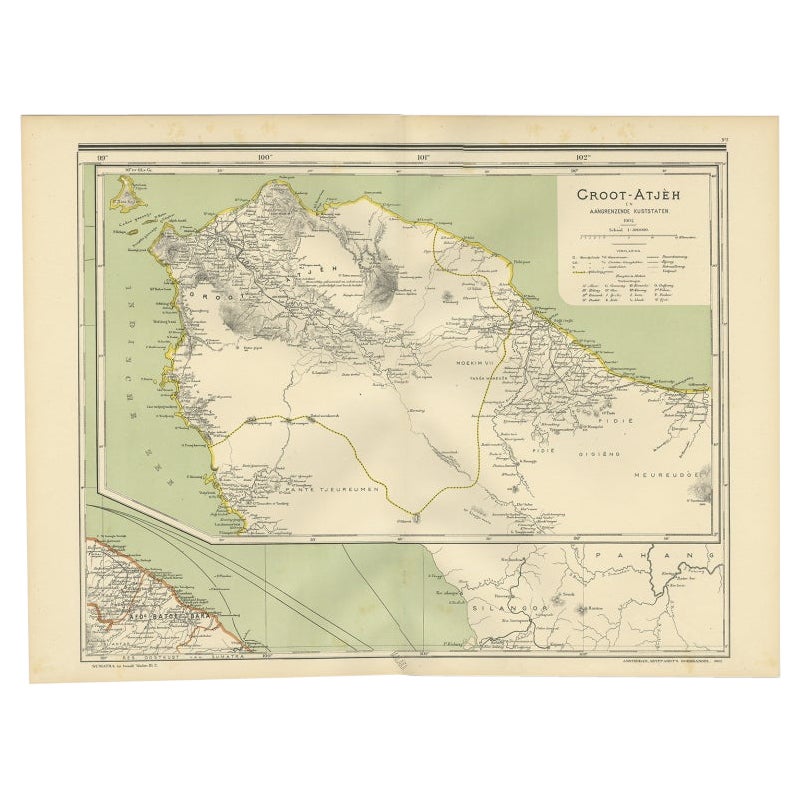
Antique Map of Aceh in Sumatra, Indonesia, 1900
Located in Langweer, NL
Antique map titled 'Groot-Atjeh en aangrenzende Kuststaten'. Old map of Aceh, with surrounding coastal regions. This map originates from 'Atlas van Nederlandsch Oost- en West-Indië' ...
Category
20th Century Maps
Materials
Paper

Antique Map of the East Coast of Sumatra , Indonesia, 1900
Located in Langweer, NL
Antique map of the East Coast of Sumatra. Also depicting the Strait of Malacca. This map originates from 'Atlas van Nederlandsch Oost- en West-Indië' by I. Dornseiffen.
Artists and...
Category
20th Century Maps
Materials
Paper

Antique Map of West Sumatra, Indonesia, 1900
Located in Langweer, NL
Antique map titled 'Sumatra, Bangka, Blitoeng en de Riouw-Archipel'. Old map of West Sumatra depicting the various islands and the Strait of Malacca. This map originates from 'Atlas ...
Category
20th Century Maps
Materials
Paper

$278 Sale Price
20% Off
Antique Map of the Nias Archipelago, Sumatra, Indonsia, 1900
Located in Langweer, NL
Antique map of Nias Island and surrounding islands including the Banyak islands, Pini island and Simeulue Island. This map originates from 'Atlas van Nederlandsch Oost- en West-Indië...
Category
20th Century Maps
Materials
Paper

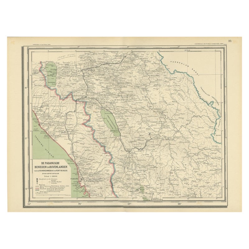
Antique Map of Padang, Sumatra, Indonesia, 1900
Located in Langweer, NL
Antique map titled 'De Padangsche Beneden-en Bovenlanden van de Koninginnedbaai tot Fort de Kock'. Old map of Padang, Sumatra. This map originates from 'Atlas van Nederlandsch Oost- ...
Category
20th Century Maps
Materials
Paper
You May Also Like
Antique 1803 Italian Map of Asia Including China Indoneseia India
Located in Amsterdam, Noord Holland
Antique 1803 Italian Map of Asia Including China Indoneseia India
Very nice map of Asia. 1803.
Additional information:
Type: Map
Country of Manufacturing: Europe
Period: 19th centu...
Category
Antique 19th Century European Maps
Materials
Paper

$584 Sale Price
20% Off
Original Antique Map of South East Asia by Thomas Clerk, 1817
Located in St Annes, Lancashire
Great map of South East Asia
Copper-plate engraving
Drawn and engraved by Thomas Clerk, Edinburgh.
Published by Mackenzie And Dent, 1817
Unframed.
Category
Antique 1810s English Maps
Materials
Paper

Large Original Antique Map of The Bahamas. 1894
Located in St Annes, Lancashire
Superb Antique map of The Bahamas
Published Edward Stanford, Charing Cross, London 1894
Original colour
Good condition
Unframed.
Free shipping
Category
Antique 1890s English Maps
Materials
Paper

Large Original Antique Map of Java and Borneo, Fullarton, C.1870
Located in St Annes, Lancashire
Great map of Java and Borneo
Wonderful figurative borders
From the celebrated Royal Illustrated Atlas
Lithograph. Original color.
Published by Fullarton, Edinburgh. C.1870
Unfr...
Category
Antique 1870s Scottish Maps
Materials
Paper

Antique French Map of Asia Including China Indoneseia India, 1783
Located in Amsterdam, Noord Holland
Very nice map of Asia. 1783 Dedie au Roy.
Additional information:
Country of Manufacturing: Europe
Period: 18th century Qing (1661 - 1912)
Condition: Overall Condition B (Good Used)...
Category
Antique 18th Century European Maps
Materials
Paper

$648 Sale Price
20% Off
Large Original Vintage Map of S.E Asia, with a Vignette of Singapore
Located in St Annes, Lancashire
Great map of South East Asia
Original color. Good condition
Published by Alexander Gross
Unframed.
Category
Vintage 1920s English Maps
Materials
Paper

More Ways To Browse
Framed Map Of Paris
Used Nautical Charts
Antique Navigator
Map Of Middle East
Antique Map Of Switzerland
World Map Copper
British Empire Map
Malaysian Antique Furniture
Birds Eye View Map
Map Of Arabia
Map Of Vienna
Old School Maps
Balinese Wood
Joan Blaeu
Antique Nautical Maps
Antique Portuguese Plates
Antique Maps California
New Zealand Map