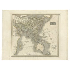
Items Similar to Antique Map of Asia and Australia with a Speculative Coastline, 1777


Want more images or videos?
Request additional images or videos from the seller
1 of 5
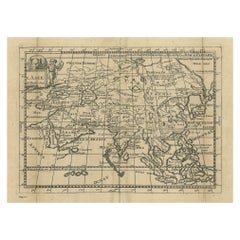
Antique Map of Asia and Australia with a Speculative Coastline, 1777
$402.58
$503.2220% Off
£299.69
£374.6120% Off
€336
€42020% Off
CA$551.43
CA$689.2920% Off
A$613.31
A$766.6420% Off
CHF 320.25
CHF 400.3120% Off
MX$7,463.32
MX$9,329.1520% Off
NOK 4,090.09
NOK 5,112.6220% Off
SEK 3,835.79
SEK 4,794.7320% Off
DKK 2,557.85
DKK 3,197.3120% Off
Shipping
Retrieving quote...The 1stDibs Promise:
Authenticity Guarantee,
Money-Back Guarantee,
24-Hour Cancellation
About the Item
Antique map titled 'A New & Accurate Map of Asia'. Detailed map of Asia and Australia, shows a still largely speculative Southern Australian coastline. Originates from Middleton's 'Complete System of Geography'.
Artists and Engravers: Engraved by Thomas Bowen.
Condition: Good, repair on folding line and few tiny tears. Please study image carefully.
Date: 1777
Overall size: 45 x 33.5 cm.
Image size: 41 x 31.5 cm.
We sell original antique maps to collectors, historians, educators and interior decorators all over the world. Our collection includes a wide range of authentic antique maps from the 16th to the 20th centuries. Buying and collecting antique maps is a tradition that goes back hundreds of years. Antique maps have proved a richly rewarding investment over the past decade, thanks to a growing appreciation of their unique historical appeal. Today the decorative qualities of antique maps are widely recognized by interior designers who appreciate their beauty and design flexibility. Depending on the individual map, presentation, and context, a rare or antique map can be modern, traditional, abstract, figurative, serious or whimsical. We offer a wide range of authentic antique maps for any budget.
- Dimensions:Height: 13.19 in (33.5 cm)Width: 17.72 in (45 cm)Depth: 0 in (0.01 mm)
- Materials and Techniques:
- Period:
- Date of Manufacture:1777
- Condition:
- Seller Location:Langweer, NL
- Reference Number:Seller: BGJC-0721stDibs: LU3054326089642
About the Seller
5.0
Recognized Seller
These prestigious sellers are industry leaders and represent the highest echelon for item quality and design.
Platinum Seller
Premium sellers with a 4.7+ rating and 24-hour response times
Established in 2009
1stDibs seller since 2017
2,510 sales on 1stDibs
Typical response time: <1 hour
- ShippingRetrieving quote...Shipping from: Langweer, Netherlands
- Return Policy
Authenticity Guarantee
In the unlikely event there’s an issue with an item’s authenticity, contact us within 1 year for a full refund. DetailsMoney-Back Guarantee
If your item is not as described, is damaged in transit, or does not arrive, contact us within 7 days for a full refund. Details24-Hour Cancellation
You have a 24-hour grace period in which to reconsider your purchase, with no questions asked.Vetted Professional Sellers
Our world-class sellers must adhere to strict standards for service and quality, maintaining the integrity of our listings.Price-Match Guarantee
If you find that a seller listed the same item for a lower price elsewhere, we’ll match it.Trusted Global Delivery
Our best-in-class carrier network provides specialized shipping options worldwide, including custom delivery.More From This Seller
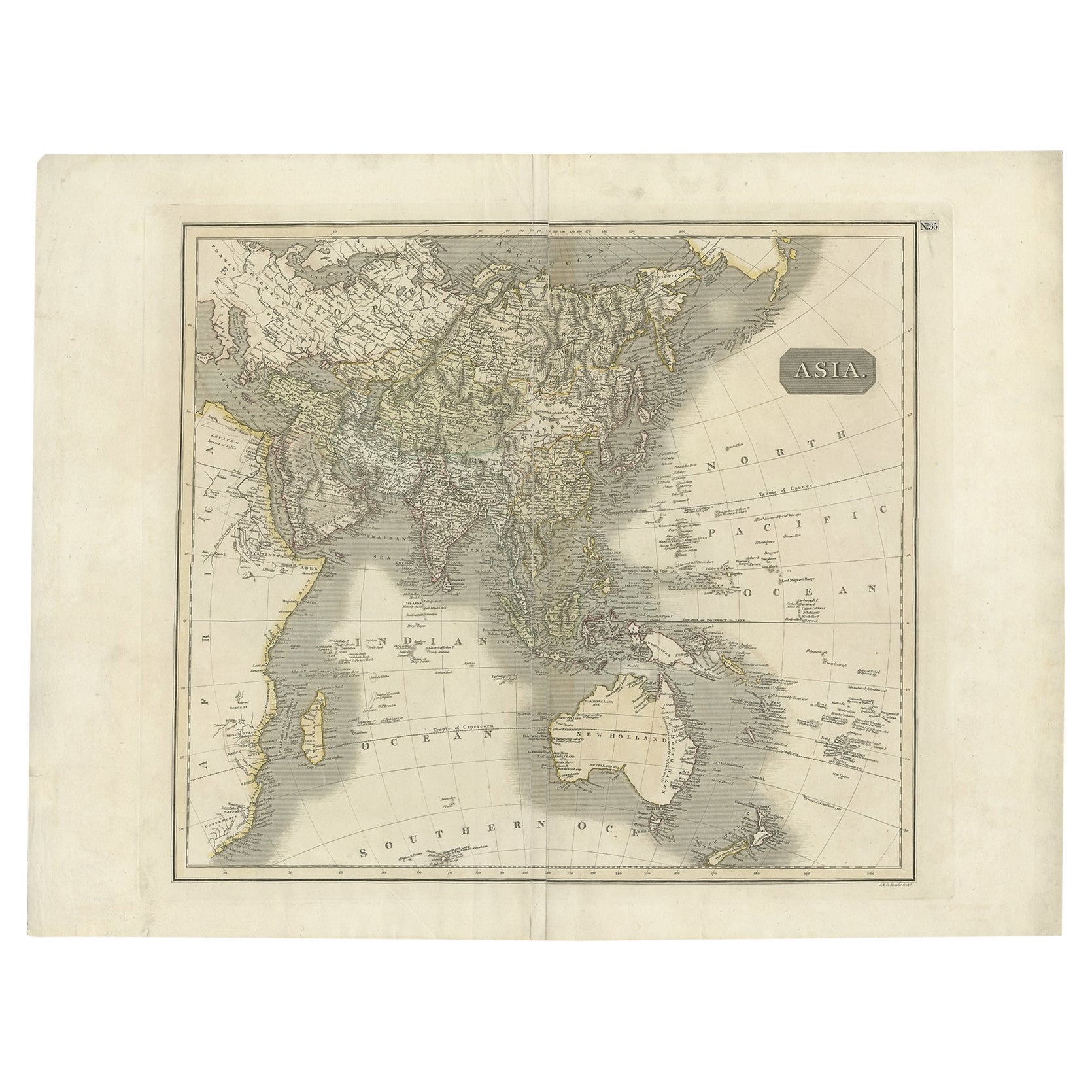
View AllAntique Map of Asia Depicting Asia and Australia, c.1814
Located in Langweer, NL
Antique map titled 'Asia'. This map depicts Asia and Australia. Engraved by J. and G. Menzies and issued for Thomson's 'New General Atlas'.
Artists and Engravers: John Thomson (1...
Category
Antique 19th Century Maps
Materials
Paper
$335 Sale Price
20% Off
Antique Map of Asia by Guthrie, 1787
Located in Langweer, NL
Antique map titled 'Asia from the best Authorities'. Old map of the Asian continent. This map originates from 'A New Geographical, Historical and Commercial Grammar; and Present State of the several Kingdoms of the World' 10th ed. by W. Guthrie.
Artists and Engravers: Published by Ch.Dilly; GGJ...
Category
Antique 18th Century Maps
Materials
Paper

$138 Sale Price
20% Off
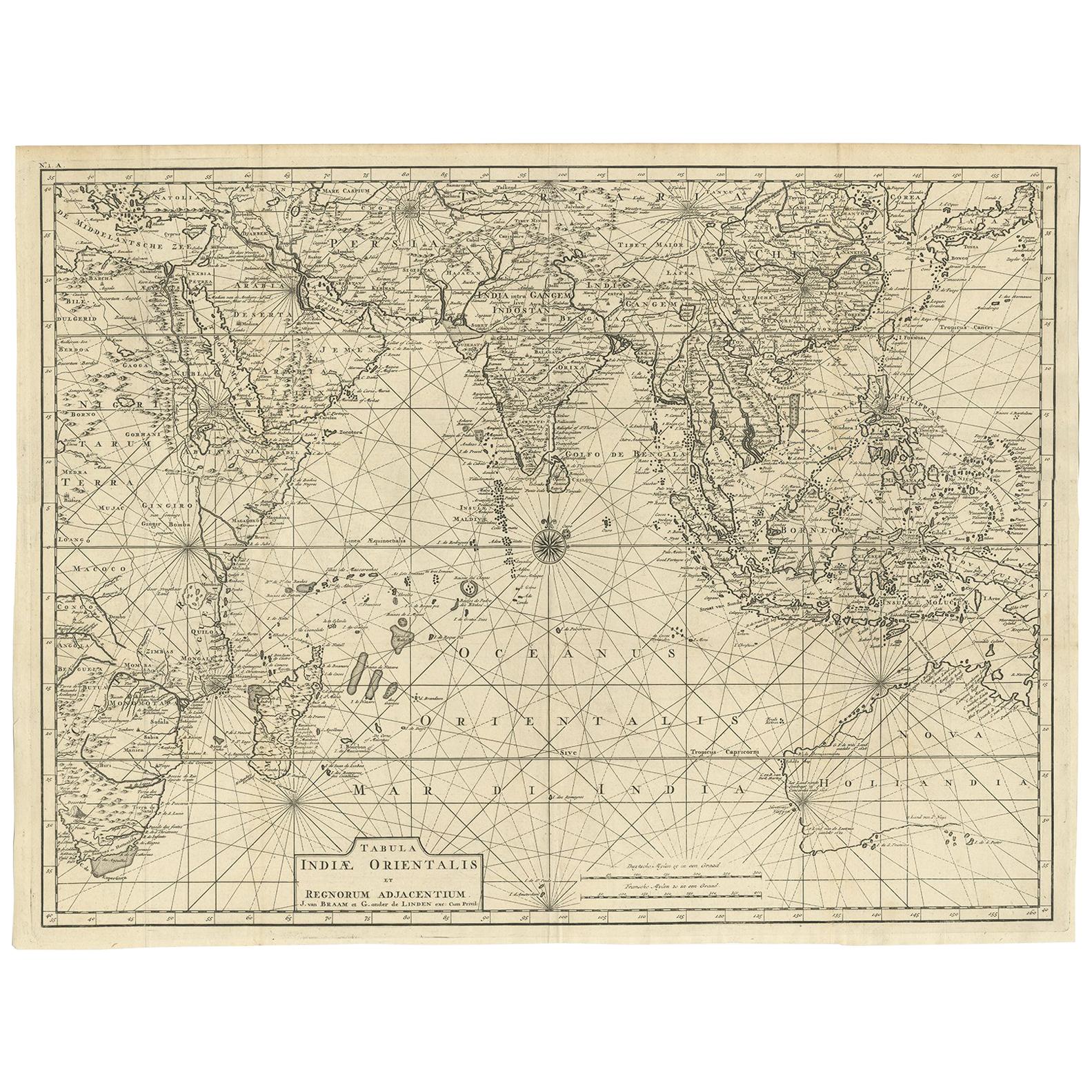
Antique Map of South East Asia, Australia and the Indian Ocean, 1726
By F. Valentijn
Located in Langweer, NL
Antique map titled 'Tabula Indiae Orientalis'.
Beautiful detailed map of Australia, Southeast Asia and the Indian Ocean. The map features a fine depiction of the outlines of the western two-thirds of Australia, based on the discoveries of explorers working for the Dutch East India Company (the VOC). These include Willem Jansz's discoveries in the Gulf of Carpentaria in 1606; the encounters of Dirk...
Category
Antique Mid-18th Century Dutch Maps
Materials
Paper

$6,901 Sale Price
20% Off
Free Shipping
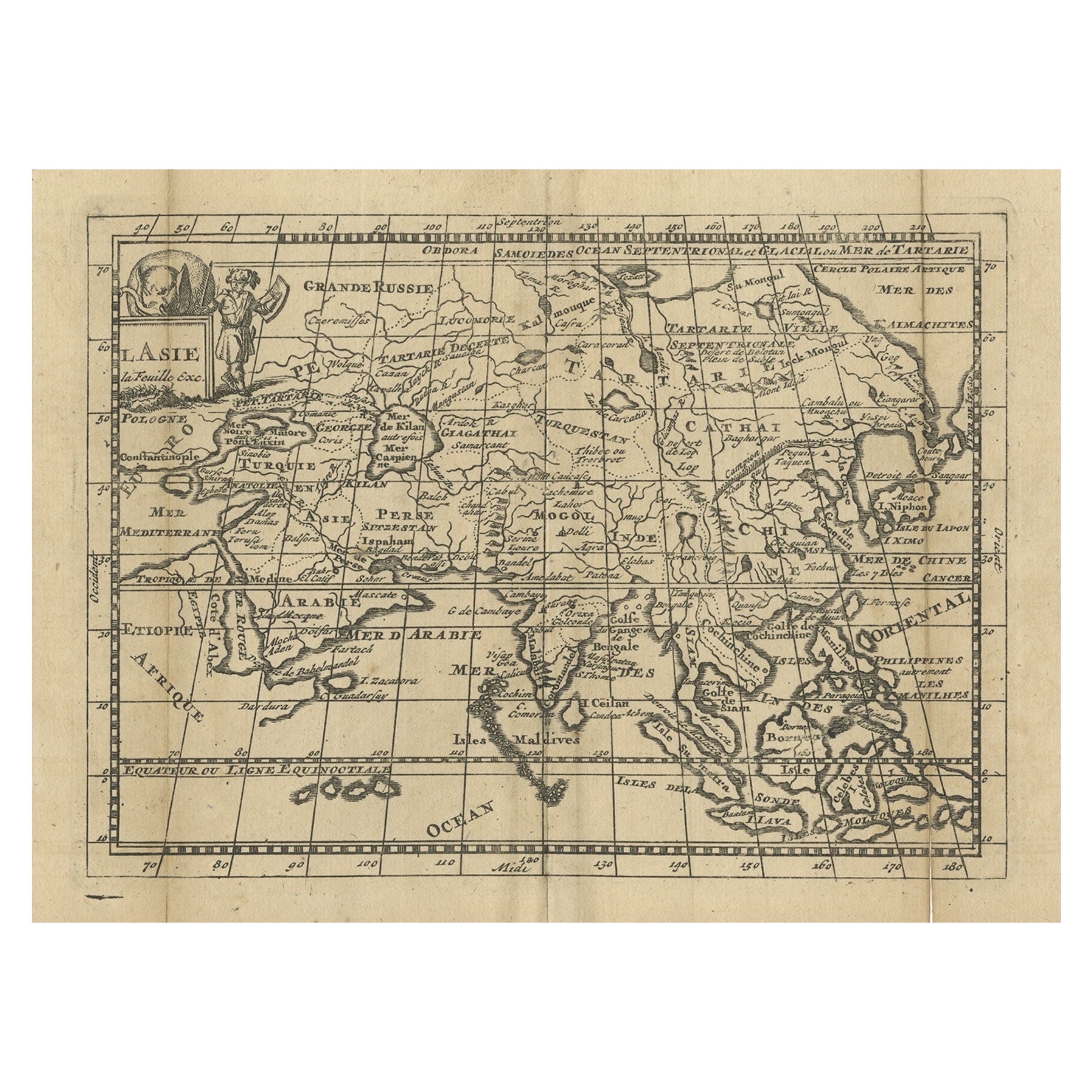
Antique Map of Asia with Misshaped Coastlines and Distorted Islands c.1760
Located in Langweer, NL
Antique map titled 'L’Asie la feuille exc'. Old map of Asia. The map contains several misshaped coastlines and distorted islands with a small cartouche held by an elephant in the top...
Category
Antique 18th Century Maps
Materials
Paper
$133 Sale Price
20% Off
Antique Map of Asia by Sanson, circa 1705
By Nicolas Sanson
Located in Langweer, NL
Dutch edition of Sanson's map of Asia. Shows a large, dramatic version of Terre de Jesso, drawn from the discoveries of the Maarten de Vries expedition of 1643.
Category
Antique Early 18th Century Dutch Maps
Materials
Paper

$383 Sale Price
20% Off
Antique Map of Asia by A. Blondeau, circa 1800
Located in Langweer, NL
This is a fine circa 1800 map of Asia by Alexandre Blondeau. It covers the entire continent from Africa and the Mediterranean east to the Bering Sea and south as far as Java and New ...
Category
Antique Early 19th Century Maps
Materials
Paper

$268 Sale Price
20% Off
You May Also Like
Antique 1803 Italian Map of Asia Including China Indoneseia India
Located in Amsterdam, Noord Holland
Antique 1803 Italian Map of Asia Including China Indoneseia India
Very nice map of Asia. 1803.
Additional information:
Type: Map
Country of Manufacturing: Europe
Period: 19th centu...
Category
Antique 19th Century European Maps
Materials
Paper

$584 Sale Price
20% Off
Original Antique Map of Australia by Dower, circa 1835
Located in St Annes, Lancashire
Nice map of Australia
Drawn and engraved by J.Dower
Published by Orr & Smith. C.1835
Unframed.
Free shipping
Category
Antique 1830s English Maps
Materials
Paper

Large Original Antique Map of Australia by Sidney Hall, 1847
Located in St Annes, Lancashire
Great map of Australia
Drawn and engraved by Sidney Hall
Steel engraving
Original colour outline
Published by A & C Black. 1847
Unframed
Free shipping.
Category
Antique 1840s Scottish Maps
Materials
Paper

Original Antique Map of The World by Thomas Clerk, 1817
Located in St Annes, Lancashire
Great map of The Eastern and Western Hemispheres
On 2 sheets
Copper-plate engraving
Drawn and engraved by Thomas Clerk, Edinburgh.
Published by Mackenzie And Dent, 1817
...
Category
Antique 1810s English Maps
Materials
Paper

Antique French Map of Asia Including China Indoneseia India, 1783
Located in Amsterdam, Noord Holland
Very nice map of Asia. 1783 Dedie au Roy.
Additional information:
Country of Manufacturing: Europe
Period: 18th century Qing (1661 - 1912)
Condition: Overall Condition B (Good Used)...
Category
Antique 18th Century European Maps
Materials
Paper

$648 Sale Price
20% Off
Original Antique Map of The Eastern Hemisphere by Dower, circa 1835
Located in St Annes, Lancashire
Nice map of the Eastern Hemisphere
Drawn and engraved by J.Dower
Published by Orr & Smith. C.1835
Unframed.
Free shipping
Category
Antique 1830s English Maps
Materials
Paper

More Ways To Browse
Australian Antique Furniture
Antique Navigator
Map Of Middle East
Antique Map Of Switzerland
World Map Copper
British Empire Map
Malaysian Antique Furniture
Birds Eye View Map
Map Of Arabia
Map Of Vienna
Old School Maps
Balinese Wood
Joan Blaeu
Antique Nautical Maps
Antique Portuguese Plates
Antique Maps California
New Zealand Map
Antique Railroad Collectibles