Items Similar to Antique Map of Asia by Dufour, circa 1834


Want more images or videos?
Request additional images or videos from the seller
1 of 5
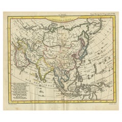
Antique Map of Asia by Dufour, circa 1834
$191.70
$239.6320% Off
£142.68
£178.3520% Off
€160
€20020% Off
CA$262.59
CA$328.2320% Off
A$292.05
A$365.0720% Off
CHF 152.50
CHF 190.6320% Off
MX$3,553.96
MX$4,442.4520% Off
NOK 1,947.66
NOK 2,434.5820% Off
SEK 1,826.57
SEK 2,283.2120% Off
DKK 1,218.02
DKK 1,522.5320% Off
Shipping
Retrieving quote...The 1stDibs Promise:
Authenticity Guarantee,
Money-Back Guarantee,
24-Hour Cancellation
About the Item
Antique map titled 'Asie par A.H. Dufour'. Uncommon map of Asia. Published by or after A.H. Dufour, circa 1834. Source unknown, to be determined.
- Dimensions:Height: 8.08 in (20.5 cm)Width: 10.44 in (26.5 cm)Depth: 0.02 in (0.5 mm)
- Materials and Techniques:
- Period:
- Date of Manufacture:1834
- Condition:General age-related toning, original folding lines. Blank verso, please study images carefully.
- Seller Location:Langweer, NL
- Reference Number:Seller: JAK-12551stDibs: LU3054319619482
About the Seller
5.0
Recognized Seller
These prestigious sellers are industry leaders and represent the highest echelon for item quality and design.
Platinum Seller
Premium sellers with a 4.7+ rating and 24-hour response times
Established in 2009
1stDibs seller since 2017
2,508 sales on 1stDibs
Typical response time: <1 hour
- ShippingRetrieving quote...Shipping from: Langweer, Netherlands
- Return Policy
Authenticity Guarantee
In the unlikely event there’s an issue with an item’s authenticity, contact us within 1 year for a full refund. DetailsMoney-Back Guarantee
If your item is not as described, is damaged in transit, or does not arrive, contact us within 7 days for a full refund. Details24-Hour Cancellation
You have a 24-hour grace period in which to reconsider your purchase, with no questions asked.Vetted Professional Sellers
Our world-class sellers must adhere to strict standards for service and quality, maintaining the integrity of our listings.Price-Match Guarantee
If you find that a seller listed the same item for a lower price elsewhere, we’ll match it.Trusted Global Delivery
Our best-in-class carrier network provides specialized shipping options worldwide, including custom delivery.More From This Seller
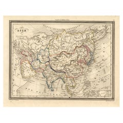
View AllAntique Map of Asia by A. Blondeau, circa 1800
Located in Langweer, NL
This is a fine circa 1800 map of Asia by Alexandre Blondeau. It covers the entire continent from Africa and the Mediterranean east to the Bering Sea and south as far as Java and New ...
Category
Antique Early 19th Century Maps
Materials
Paper

$268 Sale Price
20% Off
Antique Map of North and East Asia, 1751
Located in Langweer, NL
Map 2: 'Carte des parties nord et est de L'Asie'. (Map of the Northern parts and East Asia.) Five maps on one sheet, showing California, Alaska and Siberia, Korea and Japan. South to...
Category
Antique 18th Century Maps
Materials
Paper

Antique Map of Asia by Guthrie, 1787
Located in Langweer, NL
Antique map titled 'Asia from the best Authorities'. Old map of the Asian continent. This map originates from 'A New Geographical, Historical and Commercial Grammar; and Present State of the several Kingdoms of the World' 10th ed. by W. Guthrie.
Artists and Engravers: Published by Ch.Dilly; GGJ...
Category
Antique 18th Century Maps
Materials
Paper

$138 Sale Price
20% Off
Antique Map of North America by Dufour 'circa 1834'
Located in Langweer, NL
Antique map titled 'Amérique Septentrionale'. Uncommon map of North America. Published by or after A.H. Dufour, circa 1834. Source unknown, to be determined.
Category
Antique Mid-19th Century Maps
Materials
Paper

$191 Sale Price
20% Off
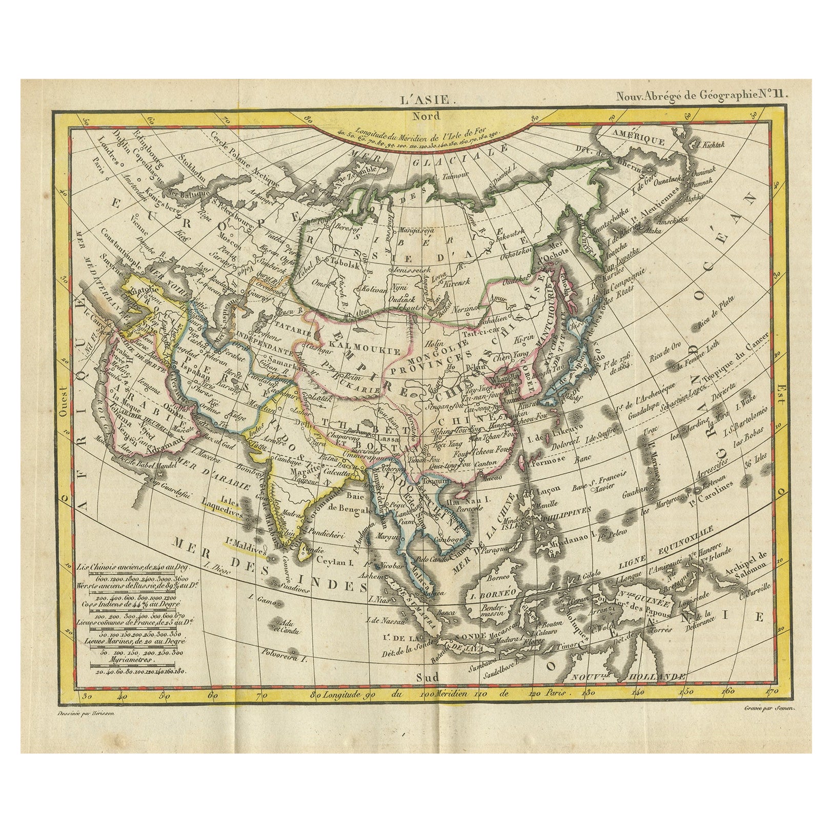
Antique Map of Asia from the Middle East to the Coast of Alaska, 1816
Located in Langweer, NL
Antique map titled ‘L’Asie‘. This is an original antique map of Asia, by Hérisson, taken from atlas ""Nouv. Abrége de Géographie"". An engraved map with coloring of Asia from the Mid...
Category
Antique 19th Century Maps
Materials
Paper
$153 Sale Price
20% Off
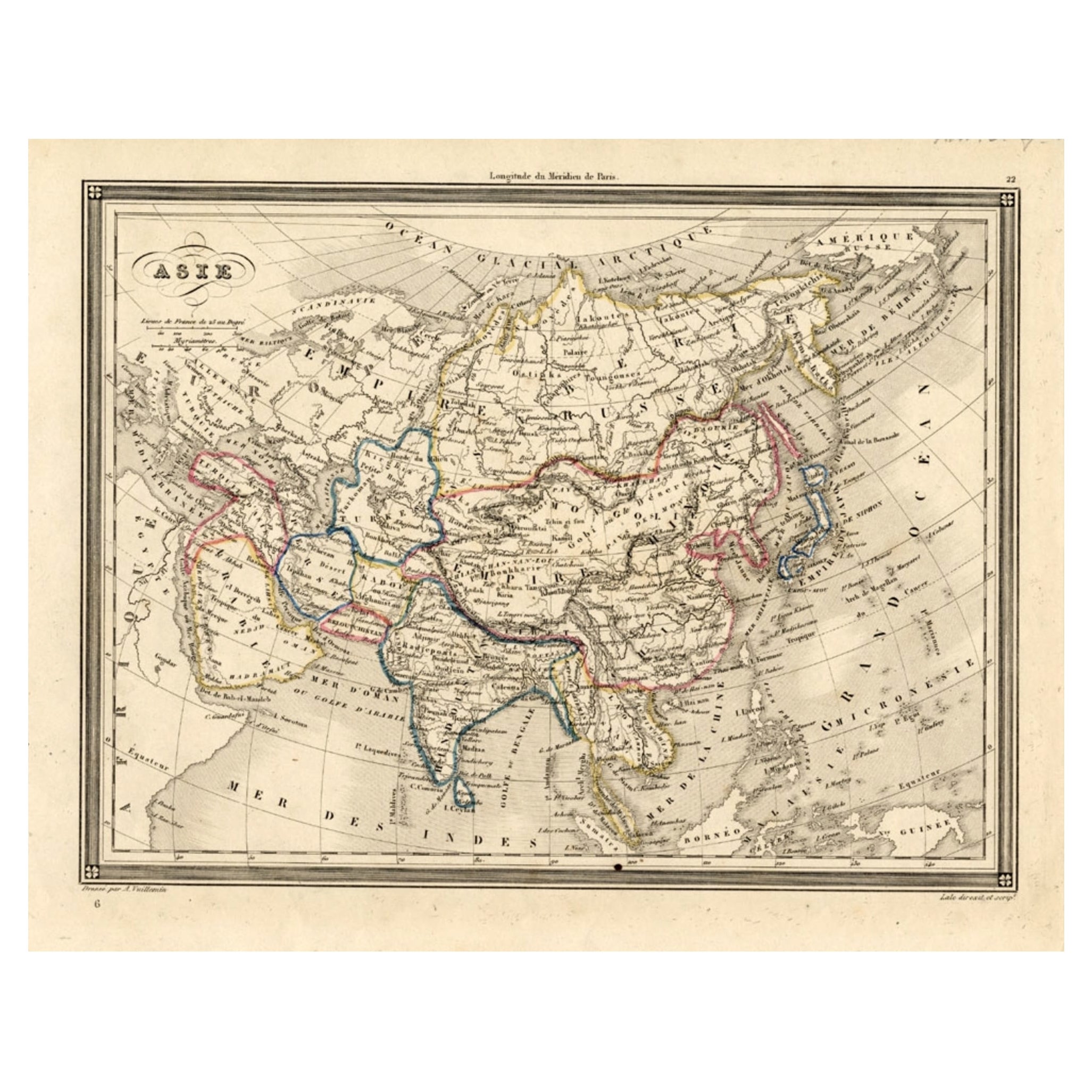
Antique Map of Asia, 1846
Located in Langweer, NL
Antique map titled 'Asie'. Original antique map of Asia. Source unknown, to be determined.
Artists and Engravers: Alexandre Vuillemin (1812-188...
Category
Antique 19th Century Maps
Materials
Paper
$74 Sale Price
20% Off
You May Also Like
Original Antique Map of The World by Thomas Clerk, 1817
Located in St Annes, Lancashire
Great map of The Eastern and Western Hemispheres
On 2 sheets
Copper-plate engraving
Drawn and engraved by Thomas Clerk, Edinburgh.
Published by Mackenzie And Dent, 1817
...
Category
Antique 1810s English Maps
Materials
Paper

Original Antique Map of The Eastern Hemisphere by Dower, circa 1835
Located in St Annes, Lancashire
Nice map of the Eastern Hemisphere
Drawn and engraved by J.Dower
Published by Orr & Smith. C.1835
Unframed.
Free shipping
Category
Antique 1830s English Maps
Materials
Paper

Antique 1803 Italian Map of Asia Including China Indoneseia India
Located in Amsterdam, Noord Holland
Antique 1803 Italian Map of Asia Including China Indoneseia India
Very nice map of Asia. 1803.
Additional information:
Type: Map
Country of Manufacturing: Europe
Period: 19th centu...
Category
Antique 19th Century European Maps
Materials
Paper

$584 Sale Price
20% Off
Original Antique Map of The World by Dower, circa 1835
Located in St Annes, Lancashire
Nice map of the World
Drawn and engraved by J.Dower
Published by Orr & Smith. C.1835
Unframed.
Free shipping
Category
Antique 1830s English Maps
Materials
Paper

Original Antique Map of The Western Hemisphere by Dower, circa 1835
Located in St Annes, Lancashire
Nice map of the Western Hemisphere
Drawn and engraved by J.Dower
Published by Orr & Smith. C.1835
Unframed.
Free shipping
Category
Antique 1830s English Maps
Materials
Paper

Original Antique Map of North America by Dower, circa 1835
Located in St Annes, Lancashire
Nice map of North America
Drawn and engraved by J.Dower
Published by Orr & Smith. C.1835
Unframed.
Free shipping
Category
Antique 1830s English Maps
Materials
Paper

More Ways To Browse
Indonesia Map
Antique Framed Map Engravings
Atlas Furniture Company
Used Office Furniture Edinburgh
Antique 16th Century Plates
Scotland Map
Antique Maps Indonesia
Map Of Japan
Antique Rollers
Compass Rose Antique
Dutch Empire
Swiss Antiques And Collectables
Antique Compass Map
Blaeu Maps
Coat Of Arms German
Antique Collectables Australia
Military Map
Spanish Empire