Items Similar to Antique Map of the Bay of Batavia by Van der Aa, c.1720


Want more images or videos?
Request additional images or videos from the seller
1 of 5
Antique Map of the Bay of Batavia by Van der Aa, c.1720
$258.80
$323.5020% Off
£192.62
£240.7820% Off
€216
€27020% Off
CA$354.49
CA$443.1120% Off
A$394.27
A$492.8420% Off
CHF 205.88
CHF 257.3420% Off
MX$4,797.85
MX$5,997.3120% Off
NOK 2,629.35
NOK 3,286.6820% Off
SEK 2,465.86
SEK 3,082.3320% Off
DKK 1,644.33
DKK 2,055.4220% Off
Shipping
Retrieving quote...The 1stDibs Promise:
Authenticity Guarantee,
Money-Back Guarantee,
24-Hour Cancellation
About the Item
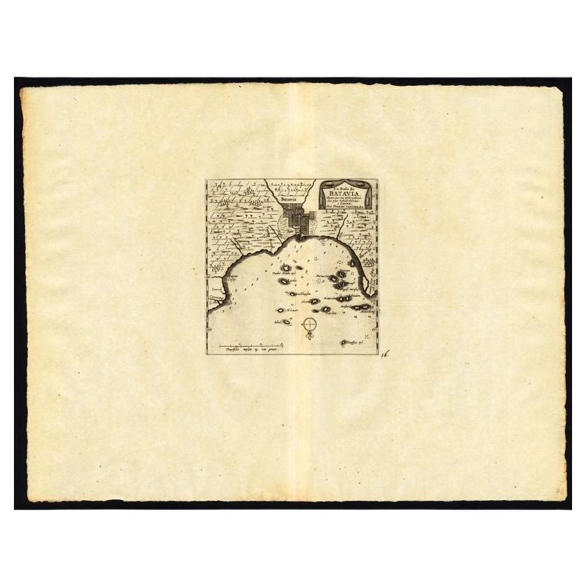
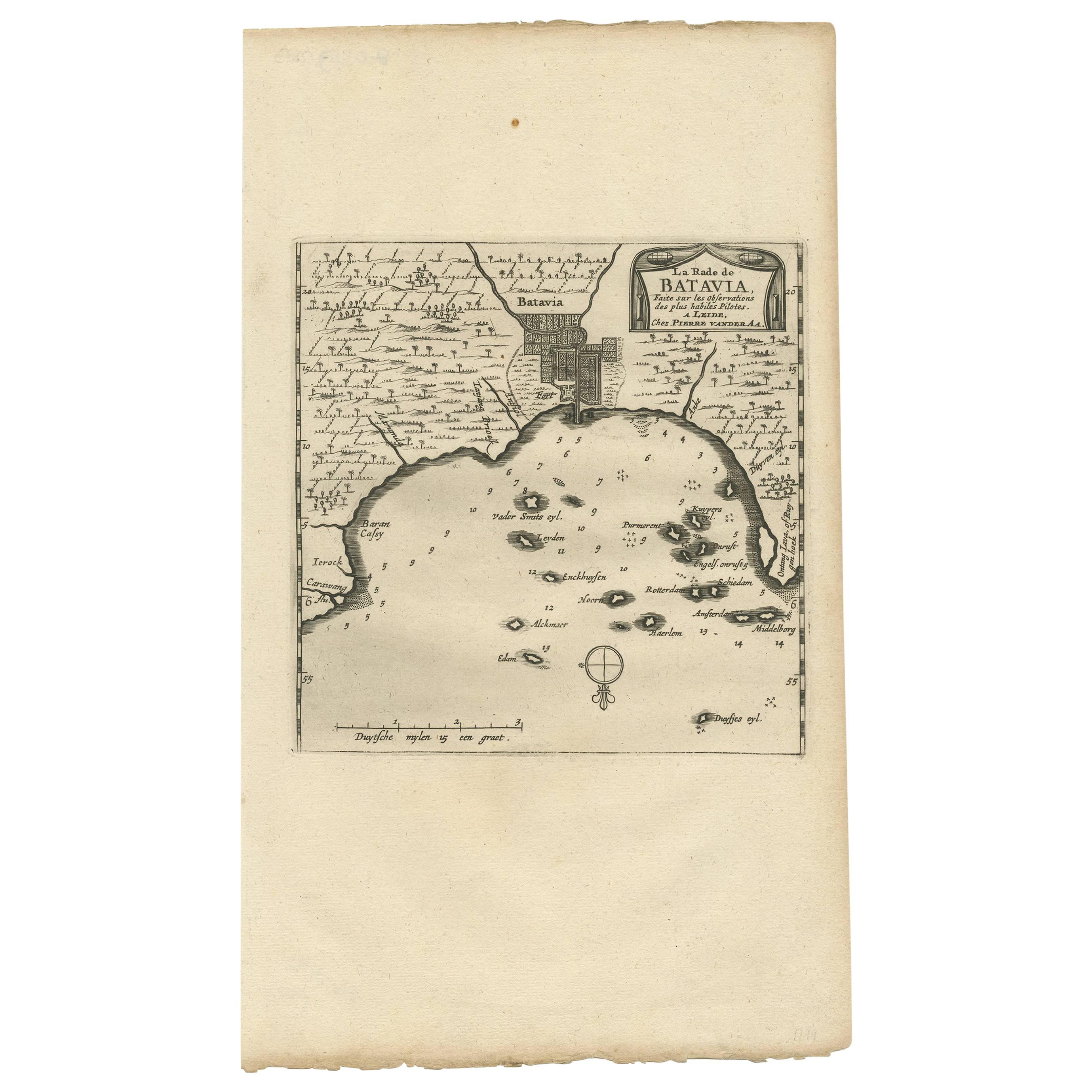
Antique map titled 'La Rade de Batavia'. A small early 18th century black and white map of the Bay of Batavia (Jakarta), Indonesia. Published by P. van der Aa, circa 1720. Artists and Engravers: Apprenticed at the age of 9, Van der Aa began his career at Leiden in 1683 as a Latin trade publisher, publishing classical texts pertaining to medicine and science. Later on, he became an engraver and publisher of atlases and maps in Leiden. His publications include an ?Atlas Nouveau? completed in about 1710, and the famous La Galerie Agréable du Monde ? one of the most impressive geographical books printed in 66 volumes in limited edition. It contains around 3000 plates, and cover the topography and people of Europe, Asia, Africa and America.
Artist: Apprenticed at the age of 9, Van der Aa began his career at Leiden in 1683 as a Latin trade publisher, publishing classical texts pertaining to medicine and science. Later on, he became an engraver and publisher of atlases and maps in Leiden. His publications include an ?Atlas Nouveau? completed in about 1710, and the famous La Galerie Agréable du Monde ? one of the most impressive geographical books printed in 66 volumes in limited edition. It contains around 3000 plates, and cover the topography and people of Europe, Asia, Africa and America.
Condition: Good, general age-related toning and/or occasional minor defects from handling. Please study scan carefully.
Date: c.1720
Overall size: 19.8 x 30.4 cm
Image size: 0.001 x 16.1 x 16.2 cm
Antique prints have long been appreciated for both their aesthetic and investment value. They were the product of engraved, etched or lithographed plates. These plates were handmade out of wood or metal, which required an incredible level of skill, patience and craftsmanship. Whether you have a house with Victorian furniture or more contemporary decor an old engraving can enhance your living space. We offer a wide range of authentic antique prints for any budget.
- Dimensions:Height: 11.97 in (30.4 cm)Width: 7.8 in (19.8 cm)Depth: 0 in (0.01 mm)
- Materials and Techniques:
- Period:
- Date of Manufacture:circa 1720
- Condition:
- Seller Location:Langweer, NL
- Reference Number:Seller: BL-000621stDibs: LU3054327774872
About the Seller
5.0
Recognized Seller
These prestigious sellers are industry leaders and represent the highest echelon for item quality and design.
Platinum Seller
Premium sellers with a 4.7+ rating and 24-hour response times
Established in 2009
1stDibs seller since 2017
2,508 sales on 1stDibs
Typical response time: <1 hour
- ShippingRetrieving quote...Shipping from: Langweer, Netherlands
- Return Policy
Authenticity Guarantee
In the unlikely event there’s an issue with an item’s authenticity, contact us within 1 year for a full refund. DetailsMoney-Back Guarantee
If your item is not as described, is damaged in transit, or does not arrive, contact us within 7 days for a full refund. Details24-Hour Cancellation
You have a 24-hour grace period in which to reconsider your purchase, with no questions asked.Vetted Professional Sellers
Our world-class sellers must adhere to strict standards for service and quality, maintaining the integrity of our listings.Price-Match Guarantee
If you find that a seller listed the same item for a lower price elsewhere, we’ll match it.Trusted Global Delivery
Our best-in-class carrier network provides specialized shipping options worldwide, including custom delivery.More From This Seller
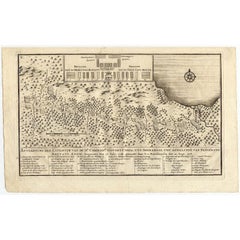
View AllAntique Map of the Bay of Bantam, c.1720
Located in Langweer, NL
Rare, untitled miniature map of the Bay of Bantam with various Islands including Pulo Dua and Pulo Batto. This map originates from a small travelogue and may originate from an editio...
Category
Antique 18th Century Maps
Materials
Paper

$57 Sale Price
20% Off
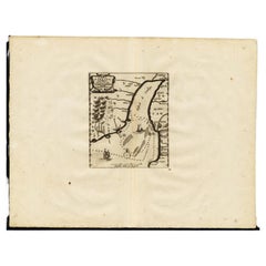
Antique Map of the Roadstead of Batavia by Van der Aa, 1725
By Pieter Van Der Aa
Located in Langweer, NL
Antique map titled 'La rade de Batavia'. (The roadstead of Batavia.) This map shows the roadstead before the Indonesian city of Batavia, nowadays Jakarta. This plate originates from ...
Category
Antique 18th Century Maps
Materials
Paper
$295 Sale Price
20% Off
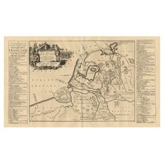
Antique Map of the Old Land of Batavia and Friesland by Halma, 1718
Located in Langweer, NL
Antique map Friesland titled 'Descriptio veteris Agri Batavi et Frisii (..)'. Old map of Friesland, the Netherlands. This map depicts the old land of Batavia and Friesland. Originate...
Category
Antique 18th Century Maps
Materials
Paper
$220 Sale Price
20% Off
Antique Map of the Expedition of Govert Knol by Valentijn, 1726
Located in Langweer, NL
Antique map titled 'Aftekening der Expeditie van de Hr. Commissaris Govert Cnoll uyt Soerabaja, tot afhalinge van Pangerang Adepati Anom'. Map showing the expedition...
Category
Antique 18th Century Maps
Materials
Paper
$103 Sale Price
20% Off
Antique Map of Batavia, Jakarta, Indonesia by P. Van Der Aa, 1719
Located in Langweer, NL
A small early 18th century black and white map of Batavia by the Dutch cartographer Pieter Van Der Aa. This map was first published in his 'Nouvel ...
Category
Antique Early 18th Century Prints
Materials
Paper

$349 Sale Price
20% Off
Antique Map of the Gulf of Cambay, Gujarat, India, 1725
By Pieter Van Der Aa
Located in Langweer, NL
Antique map titled 'Le Golfe de Cambaye at la Rade de Suratt.' (The gulf of Cambay and the coast of Surat, India.) The Gulf of Khambhat, formerly known as the Gulf of Cambay, is an i...
Category
Antique 18th Century Maps
Materials
Paper
You May Also Like
1646 Jansson Map Entitled "Procinvia Connactiae, " Ric.a006
Located in Norton, MA
1646 Jansson map entitled
"Procinvia connactiae,"
Ric.a006
Description: The PROVINCE of CONNAVGT 490 x 380From vol 4 of Jansson's Atlas Novus 1646, published in Amsterdam with...
Category
Antique 17th Century Unknown Maps
Materials
Paper

1627 Hendrik Hondius Map Entitled "Vltoniae Orientalis Pars, " Ric.a009
Located in Norton, MA
1627 Hendrik Hondius map entitled
"Vltoniae orientalis pars,"
Ric.a009
Title:
Vltoniae orientalis : pars
Title (alt.) :
Ultoniae orientalis pars
Creator:
Mercator, Gerh...
Category
Antique 17th Century Dutch Maps
Materials
Paper

Rare Original Map of New Amsterdam (New York) – “Restitutio”, ca. 1674 –
Located in Dronten, NL
An exceptionally rare and original 17th-century engraving of New Amsterdam, now New York City, published by the renowned Amsterdam cartographer Carel (Carolus) Allard around 1674. Kn...
Category
Antique 17th Century Dutch Maps
Materials
Paper

1654 Joan Blaeu Map the Sutherland, Scotland, Entitled "Southerlandia, "Ric0007
Located in Norton, MA
1654 Joan Blaeu map of the
Sutherland, Scotland, entitled
"Southerlandia,"
Hand Colored
Ric0007
Description:
Lovely map centered on Sedan and D...
Category
Antique 17th Century Dutch Maps
Materials
Paper

Cadiz Island: A Framed 17th Century Hand-colored Map from Blaeu's Atlas Major
By Joan (Johannes) Blaeu
Located in Alamo, CA
This is a 17th century hand-colored map entitled "Insula Gaditana Isla de Cadiz" from Johannes (Joan) Blaeu's Atlas Maior, published in Amsterdam in 1662.
The map provides an excellent plan of Cadiz Island on the southwest coast of Spain, with its harbor, fortifications, agricultural fields and several surrounding salt processing areas. Numerous sailing ships of various sizes are included in and around the harbor and bay, including five large sailing ships, as well as twenty-four smaller ships. There is a small compass rose overlying the bay. The bridge to the mainland from the island is shown on the right. There is an extremely ornate and colorful title cartouche in the lower left, with its mythological figures reminiscent of Raphael’s Galatea fresco at the Villa Farnesina in Rome. The vibrant colors are vividly preserved. The master colorist tried to emulate a painting by using various tones to create a three-dimensional effect.
Blaeu's name is present in the plate in the lower right. Blaeu stated in his description of Cadiz: “The main wealth of the islanders consists of salt, which they harvest, and
the tuna fisheries.”
This 17th century hand-colored map is framed in an ornate, partially textured bronze-colored wood frame and glazed with UV protected conservation glass. There is a vertical center fold, as issued. There is a faint crease in the lower right and faint color offset on the left from the right side of the map, resulting from having been in an atlas for hundreds of years. Small foci of paint are present in the upper portion of the left margin and in the left corner margin. The map is otherwise in very good condition.
Due in large part to their powerful trade empire, the Dutch became known for cartography in the seventeenth century. This period is considered the Golden Age of Dutch cartography. Their publishing houses produced the highest quality work in Europe, particularly those maps and charts of foreign lands, and Dutch map-making set the bar for cartographic accuracy and artistry into the early-eighteenth century. Some of the most well-known cartographers worked in Amsterdam during this period. Perhaps the most famous of these was the Blaeu family. Willem Janszoon Blaeu, set up shop in Amsterdam. His son, Johannes (Joan), succeeded him upon his death in 1638, continuing in his father’s position as Hydrographer to the Dutch East India Company and selling maps to the public. The Blaeu map presses, located near Amsterdam’s Dam Square...
Category
Mid-17th Century Old Masters Landscape Prints
Materials
Engraving

Antique Voc Print Holland Malaysia Old Map Melaka History, 1663
Located in Amsterdam, Noord Holland
From my own collection I offer this impressive Antique print of the city of Malakka
A very interesting piece for collectors . It is an museum piece from the Dutch Institute of Orien...
Category
Antique 17th Century European Paintings
Materials
Paper

$293 Sale Price
20% Off
More Ways To Browse
Victorian Medicine
Antique Florida Map
Map Of Syria
Napoleon Map
South Arabian
Antique Geological Maps
French School Map
Nova Scotia Antique Furniture
Richard Wentworth
Antique Mace
Map Of Madagascar
Map Of Normandy
Bali Map
Croatia Map
Gibraltar Antique Map
Albania Antique Map
Antique Furniture Kingston
Antique Louisiana Map