Items Similar to Antique Map of the Bay of Bantam, c.1720

Want more images or videos?
Request additional images or videos from the seller
1 of 5
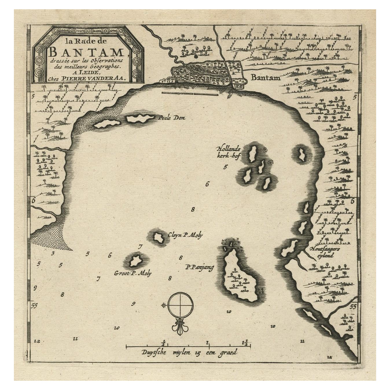
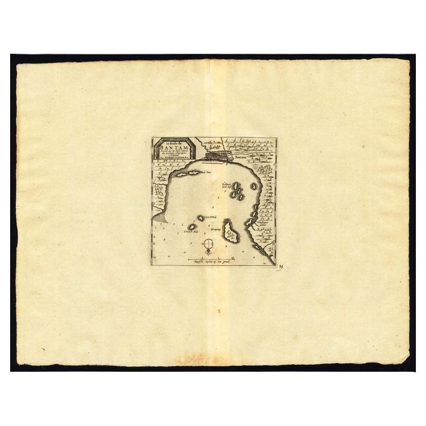
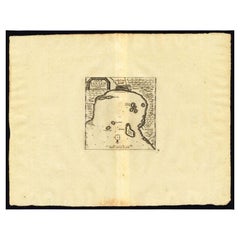
Antique Map of the Bay of Bantam, c.1720
About the Item
Rare, untitled miniature map of the Bay of Bantam with various Islands including Pulo Dua and Pulo Batto. This map originates from a small travelogue and may originate from an edition of Prevost's 'Histoire Generale des Voyages'. A larger version of this map originates from Renneville's 'Recueil des Voyages'. Artists and Engravers: Anonymous.
Artist: Anonymous.
Condition: Very good, small hole outside image border. Please study image carefully.
Date: c.1720
Overall size: 14.3 x 16 cm.
Image size: 0.001 x 12.5 x 13.7 cm.
Antique prints have long been appreciated for both their aesthetic and investment value. They were the product of engraved, etched or lithographed plates. These plates were handmade out of wood or metal, which required an incredible level of skill, patience and craftsmanship. Whether you have a house with Victorian furniture or more contemporary decor an old engraving can enhance your living space. We offer a wide range of authentic antique prints for any budget.
- Dimensions:Height: 6.3 in (16 cm)Width: 5.63 in (14.3 cm)Depth: 0 in (0.01 mm)
- Materials and Techniques:
- Period:
- Date of Manufacture:circa 1720
- Condition:
- Seller Location:Langweer, NL
- Reference Number:
About the Seller
5.0
Platinum Seller
These expertly vetted sellers are 1stDibs' most experienced sellers and are rated highest by our customers.
Established in 2009
1stDibs seller since 2017
1,919 sales on 1stDibs
Typical response time: <1 hour
- ShippingRetrieving quote...Ships From: Langweer, Netherlands
- Return PolicyA return for this item may be initiated within 14 days of delivery.
More From This SellerView All
- Antique Map of the Bay of Batavia by Van der Aa, c.1720Located in Langweer, NLAntique map titled 'La Rade de Batavia'. A small early 18th century black and white map of the Bay of Batavia (Jakarta), Indonesia. Published by P....Category
Antique 18th Century Maps
MaterialsPaper
- Antique Map of Banten Bay on Java Island, Indonesia, c.1720Located in Langweer, NLAntique map titled 'La Rade de Bantam'. A small early 18th century black and white map of Banten Bay (or Bantam Bay), located near the northwest co...Category
Antique 18th Century Maps
MaterialsPaper
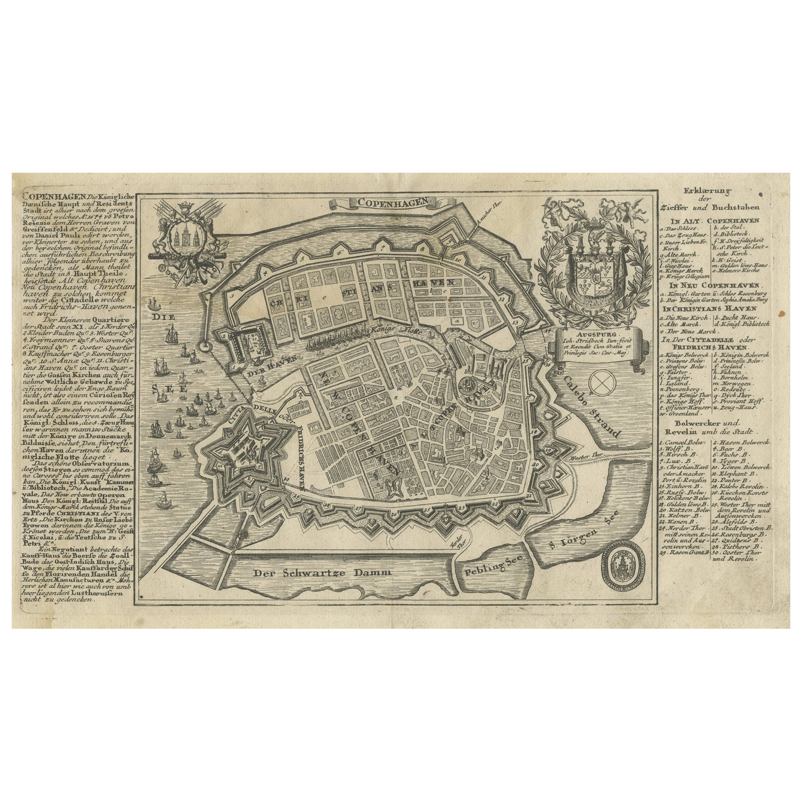
- Antique Map of the City of Copenhagen in Denmark c.1720Located in Langweer, NLAntique map titled 'Copenhagen'. Original antique map of the city of Copenhagen, Denmark. This map originates from 'Unterschiedliche dieser Zeit Beruffene Laender, Gegenden, Staedte ...Category
Antique 18th Century Maps
MaterialsPaper
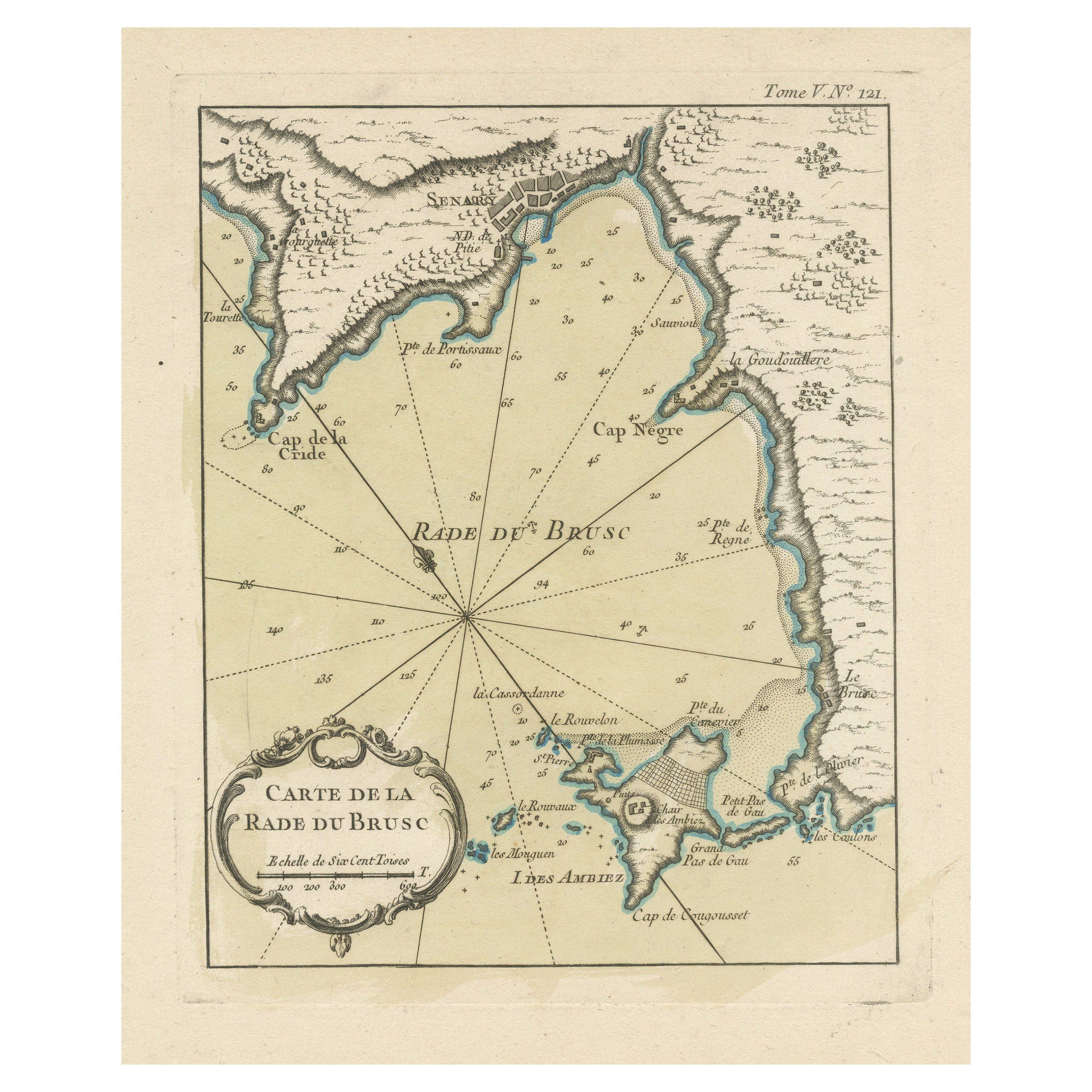
- Antique Map of the Bay of Brusc, FranceLocated in Langweer, NLAntique map titled 'Carte de la rade du Brusc'. Original map of the bay of Brusc, France. This map originates from 'Le Petit Atlas Maritime (..)' by J.N. Bellin. Published 1764. ...Category
Antique Mid-18th Century Maps
MaterialsPaper
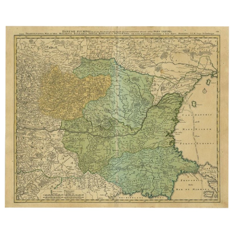
- Antique Map of the Danube River by Homann, c.1720By Homann HeirsLocated in Langweer, NLAntique map titled 'Danubii Fluminis (..)'. Regional map of the Donau river, Shows the Danube river from Belgrade in Serbia, along the border between Roma...Category
Antique 18th Century Maps
MaterialsPaper
- Antique Map of the Roadstead of Bantam by Van der Aa, 1725By Pieter Van Der AaLocated in Langweer, NLAntique map titled 'La rade de Bantam'. (The roadstead of Bantam.) This map shows the Indonesian city of Banten / Bantam on Java, Indonesia and its roadstead. With compass rose and s...Category
Antique 18th Century Maps
MaterialsPaper

You May Also Like
- Antique Coaching Road Map, Devon, English, Regional Cartography, Georgian, 1720Located in Hele, Devon, GBThis is an antique coaching road map of Devon. An English, framed lithograph engraving of regional interest, dating to the early 18th century and later. Fascinating 18th century hig...Category
Antique Early 18th Century British Georgian Maps
MaterialsWood
- 1856 U.S. Coast Survey Map of Chesapeake Bay and Delaware BayLocated in Colorado Springs, COPresented is U.S. Coast Survey nautical chart or maritime map of Chesapeake Bay and Delaware Bay from 1856. The map depicts the region from Susquehanna, Maryland to the northern Oute...Category
Antique 1850s American Maps
MaterialsPaper
- Antique Coach Road Map, East Devon, English, Framed, Cartography, Georgian, 1720Located in Hele, Devon, GBThis is an antique coach road map of East Devon. An English, framed lithograph engraving of regional interest, dating to the early 18th century and later. Fascinating 18th century h...Category
Antique Early 18th Century British Georgian Maps
MaterialsWood
- 1861 Topographical Map of the District of Columbia, by Boschke, Antique MapLocated in Colorado Springs, COPresented is an original map of Albert Boschke's extremely sought-after "Topographical Map of the District of Columbia Surveyed in the Years 1856 ...Category
Antique 1860s American Historical Memorabilia
MaterialsPaper
- Original Antique Map of the American State of Oregon, 1889Located in St Annes, LancashireGreat map of Oregon Drawn and Engraved by W. & A.K. Johnston Published By A & C Black, Edinburgh. Original colour Unframed.Category
Antique 1880s Scottish Victorian Maps
MaterialsPaper
- Original Antique Map of the American State of Pennsylvania, 1889Located in St Annes, LancashireGreat map of Pennsylvania Drawn and Engraved by W. & A.K. Johnston Published By A & C Black, Edinburgh. Original colour Unframed. Repair to a minor tear on bottom edge.Category
Antique 1880s Scottish Victorian Maps
MaterialsPaper


Recently Viewed
View AllMore Ways To Browse
Antique Miniature Plates
16c Antique Furniture
18th C Large Prints
Miniature Maps
Miniature Map
Antique Long Island Map
Antique Maps Of Long Island
Antique Map Of Long Island
Antique Map Long Island
Antique Map Paint
Israeli Antique
Tree Bag
Ohio Antique
16th Century Scotland
New England Map
New England Maps
Great Britain Maps
Used Furniture Depot