Items Similar to Antique Map of the Caucasus by Seale, 1799


Want more images or videos?
Request additional images or videos from the seller
1 of 5
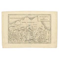
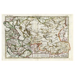
Antique Map of the Caucasus by Seale, 1799
$133.23
$166.5420% Off
£99.17
£123.9620% Off
€111.20
€13920% Off
CA$182.50
CA$228.1220% Off
A$202.98
A$253.7220% Off
CHF 105.99
CHF 132.4820% Off
MX$2,470
MX$3,087.5020% Off
NOK 1,353.63
NOK 1,692.0320% Off
SEK 1,269.46
SEK 1,586.8320% Off
DKK 846.53
DKK 1,058.1620% Off
Shipping
Retrieving quote...The 1stDibs Promise:
Authenticity Guarantee,
Money-Back Guarantee,
24-Hour Cancellation
About the Item
Antique map titled 'Sarmatia'. Old map of the Caucasus with the Caspian and Black Sea. Originates from 'Geographia Antiqua (..)'. Artists and Engravers: Richard William Seale (1703-1762) was an English mapmaker and engraver from London. Richard Seale, his father, was a member of the Stationers Company, suggesting that printing and engraving must have been a family trade. Nevertheless, he was not taught by his father, but was apprenticed to Samuel Parker of Clerkenwell in 1719. Seale was quite active as an engraver and publisher from about 1740 until his death in 1762.
Artist: Richard William Seale (1703-1762) was an English mapmaker and engraver from London. Richard Seale, his father, was a member of the Stationers Company, suggesting that printing and engraving must have been a family trade. Nevertheless, he was not taught by his father, but was apprenticed to Samuel Parker of Clerkenwell in 1719. Seale was quite active as an engraver and publisher from about 1740 until his death in 1762.
Condition: Very good, general age-related toning. Please study image carefully.
Date: 1799
Overall size: 37.5 x 25 cm.
Image size: 0.001 x 30 x 20 cm.
Antique prints have long been appreciated for both their aesthetic and investment value. They were the product of engraved, etched or lithographed plates. These plates were handmade out of wood or metal, which required an incredible level of skill, patience and craftsmanship. Whether you have a house with Victorian furniture or more contemporary decor an old engraving can enhance your living space. We offer a wide range of authentic antique prints for any budget.
- Dimensions:Height: 9.85 in (25 cm)Width: 14.77 in (37.5 cm)Depth: 0 in (0.01 mm)
- Materials and Techniques:
- Period:
- Date of Manufacture:1799
- Condition:
- Seller Location:Langweer, NL
- Reference Number:Seller: BGJC-0521stDibs: LU3054327772662
About the Seller
5.0
Recognized Seller
These prestigious sellers are industry leaders and represent the highest echelon for item quality and design.
Platinum Seller
Premium sellers with a 4.7+ rating and 24-hour response times
Established in 2009
1stDibs seller since 2017
2,508 sales on 1stDibs
Typical response time: <1 hour
- ShippingRetrieving quote...Shipping from: Langweer, Netherlands
- Return Policy
Authenticity Guarantee
In the unlikely event there’s an issue with an item’s authenticity, contact us within 1 year for a full refund. DetailsMoney-Back Guarantee
If your item is not as described, is damaged in transit, or does not arrive, contact us within 7 days for a full refund. Details24-Hour Cancellation
You have a 24-hour grace period in which to reconsider your purchase, with no questions asked.Vetted Professional Sellers
Our world-class sellers must adhere to strict standards for service and quality, maintaining the integrity of our listings.Price-Match Guarantee
If you find that a seller listed the same item for a lower price elsewhere, we’ll match it.Trusted Global Delivery
Our best-in-class carrier network provides specialized shipping options worldwide, including custom delivery.More From This Seller
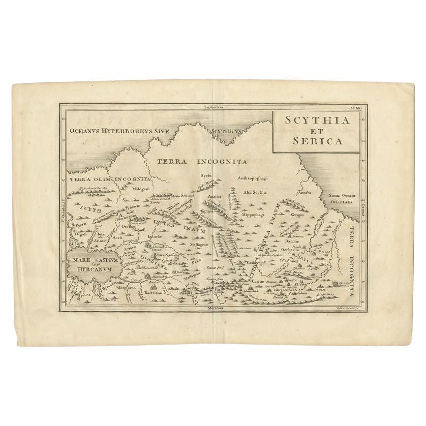
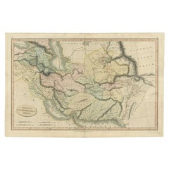
View AllAntique Map of the Region Between the Caspian and the Sea of China by Toms, 1799
Located in Langweer, NL
Antique map titled 'Scythia et Serica'. Old map of the region between the Caspian and the Sea of China. Originates from 'Geographia Antiqua (..)'.
Artists and Engravers: Engraved ...
Category
Antique 18th Century Maps
Materials
Paper
$133 Sale Price
20% Off
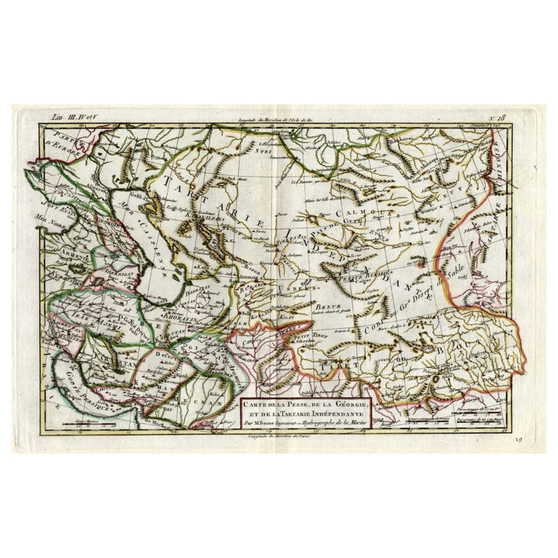
Antique Map of the Persian Gulf and Caspian Sea Region by R. Bonne, 1780
Located in Langweer, NL
Antique print titled 'Carte de la Perse, de la Georgie, et de la Tartarie Independante'. Shows the region from the Persian Gulf and Caspian Sea in the wes...
Category
Antique Late 18th Century French Maps
Materials
Paper

Antique Map of Persia, Georgia and Kazakhstan, ca.1780
Located in Langweer, NL
Antique map titled 'Carte de la Perse, de la Georgie, et de la Tartarie Independante'.
Map of Persia, Georgia and Kazakhstan. This map shows current days Georgia, Iran, Irak, Kaz...
Category
Antique 1780s Maps
Materials
Paper
$498 Sale Price
20% Off
Antique Map of the Region Between the Black and Caspian Sea by Cellarius, 1731
Located in Langweer, NL
Antique map titled 'Bosporus, Maeotis, Iberia, Albania, et Sarmatia Asiatica.' Map of the region between the Black and Caspian Seas in early Sarmatian time...
Category
Antique 18th Century Maps
Materials
Paper
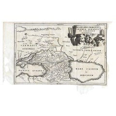
$167 Sale Price
20% Off
Antique Map of Russia in Europe by T. Kitchin, circa 1770
Located in Langweer, NL
Antique map titled 'Russia or Moscovy in Europe, drawn from the latest authorities (..)'. An interesting and attractive early 19th century map of Russia in Europe which was engraved ...
Category
Antique Late 18th Century Maps
Materials
Paper

$153 Sale Price
20% Off
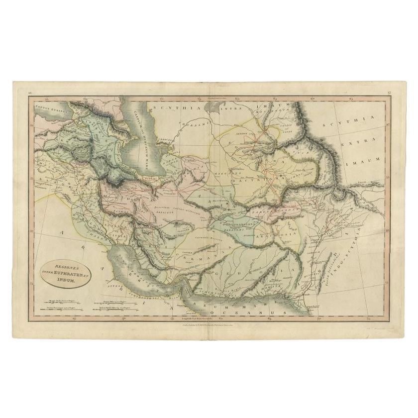
Antique Map of the Middle East by Smith, 1809
Located in Langweer, NL
Antique map titled 'Regiones inter Euphraten et Indum'. Old map of the Middle East showing the region between the Euphrates and Indus river. Ori...
Category
Antique 19th Century Maps
Materials
Paper
$129 Sale Price
20% Off
You May Also Like
Original Antique Map of Ancient Greece, Achaia, Corinth, 1786
Located in St Annes, Lancashire
Great map of Ancient Greece. Showing the region of Thessaly, including Mount Olympus
Drawn by J.D. Barbie Du Bocage
Copper plate engraving by P.F Tardieu
Original hand color...
Category
Antique 1780s French Other Maps
Materials
Paper

Original Antique Map of Ancient Greece- Boeotia, Thebes, 1787
Located in St Annes, Lancashire
Great map of Ancient Greece. Showing the region of Boeotia, including Thebes
Drawn by J.D. Barbie Du Bocage
Copper plate engraving by P.F T...
Category
Antique 1780s French Other Maps
Materials
Paper

Original Antique Map of Hungary, Arrowsmith, 1820
Located in St Annes, Lancashire
Great map of Hungary
Drawn under the direction of Arrowsmith.
Copper-plate engraving.
Published by Longman, Hurst, Rees, Orme and Brown, 1820
Unframed.
Category
Antique 1820s English Maps
Materials
Paper

1790 Thomas Stackhouse Map, Entitled "Russia in Europe, " , Ric.a004
Located in Norton, MA
1790 Thomas Stackhouse map, entitled
"Russia in Europe"
Ric.a004
Stackhouse, Thomas
Russia in Europe [map]
London: T. Stackhouse, 1783. Map. Matted hand-colored copper engraving. Image size: 14.5 x 15.25 inches. Mat size: 22.75 x 23.75 inches. A beautiful example of this map of Eastern Europe...
Category
Antique 17th Century Unknown Maps
Materials
Paper

18th Century Map of the Southern Balkans by Giovanni Maria Cassini
By Giovanni Maria Cassini
Located in Hamilton, Ontario
18th century map by Italian engraver Giovanni Maria Cassini (Italy 1745-1824).
Map of the Southern Balkans: Rome. Hand colored and copper engraved print done in the year 1788. It in...
Category
Antique 18th Century Italian Maps
Materials
Paper

$795 Sale Price
36% Off
1814 Map of "Russian Empire" Ric.r032
Located in Norton, MA
1814 Map of
"Russian Empire"
Ric.r032
Russian Empire. Description: This is an 1814 John Thomson map of the Russian Empire. The map depicts the region from the Baltic Sea, Prussia, and Sweden to the Aleutian Islands and from the Arctic Ocean to the Yellow River. Highly detailed, myriad cities, towns, and villages are labeled throughout, including St. Petersburg, Moscow, Minsk, Kiev, and Kharkov. Rivers and mountain ranges are also identified, as are islands and numerous locations along the coastlines. It is important to note that the long-disputed sea between Korea and Japan is identified as the 'Sea of Japan.
Historical Context:
In 1815, Tsarist Russia emerged from the Napoleonic Wars economically insolvent and politically fearful of the Revolutionary fervor that had just swept through Europe. In order to shore up Russia's economic position, the Tsars began an aggressive series of expansions into the Caucuses and Central Asia that would vastly increase the landmass of the Russian Empire.
Publication History
Thomson maps are known for their stunning color, awe inspiring size, and magnificent detail. Thomson's work, including this map, represents some of the finest cartographic art...
Category
Antique 19th Century Unknown Maps
Materials
Paper
