Items Similar to Antique Map of the Region Between the Caspian and the Sea of China by Toms, 1799


Want more images or videos?
Request additional images or videos from the seller
1 of 5
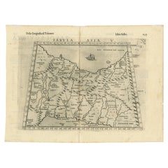
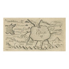
Antique Map of the Region Between the Caspian and the Sea of China by Toms, 1799
About the Item
Antique map titled 'Scythia et Serica'. Old map of the region between the Caspian and the Sea of China. Originates from 'Geographia Antiqua (..)'.
Artists and Engravers: Engraved by W.H. Toms.
Condition: Very good, general age-related toning. Please study image carefully.
Date: 1799
Overall size: 39 x 26 cm.
Image size: 30 x 20 cm.
We sell original antique maps to collectors, historians, educators and interior decorators all over the world. Our collection includes a wide range of authentic antique maps from the 16th to the 20th centuries. Buying and collecting antique maps is a tradition that goes back hundreds of years. Antique maps have proved a richly rewarding investment over the past decade, thanks to a growing appreciation of their unique historical appeal. Today the decorative qualities of antique maps are widely recognized by interior designers who appreciate their beauty and design flexibility. Depending on the individual map, presentation, and context, a rare or antique map can be modern, traditional, abstract, figurative, serious or whimsical. We offer a wide range of authentic antique maps for any budget.
- Dimensions:Height: 10.24 in (26 cm)Width: 15.36 in (39 cm)Depth: 0 in (0.01 mm)
- Materials and Techniques:
- Period:
- Date of Manufacture:1799
- Condition:
- Seller Location:Langweer, NL
- Reference Number:
About the Seller
5.0
Platinum Seller
These expertly vetted sellers are 1stDibs' most experienced sellers and are rated highest by our customers.
Established in 2009
1stDibs seller since 2017
1,929 sales on 1stDibs
Typical response time: <1 hour
- ShippingRetrieving quote...Ships From: Langweer, Netherlands
- Return PolicyA return for this item may be initiated within 14 days of delivery.
More From This SellerView All
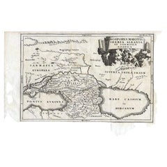
- Antique Map of the Region Between the Black and Caspian Sea by Cellarius, 1731Located in Langweer, NLAntique map titled 'Bosporus, Maeotis, Iberia, Albania, et Sarmatia Asiatica.' Map of the region between the Black and Caspian Seas in early Sarmatian time...Category
Antique 18th Century Maps
MaterialsPaper
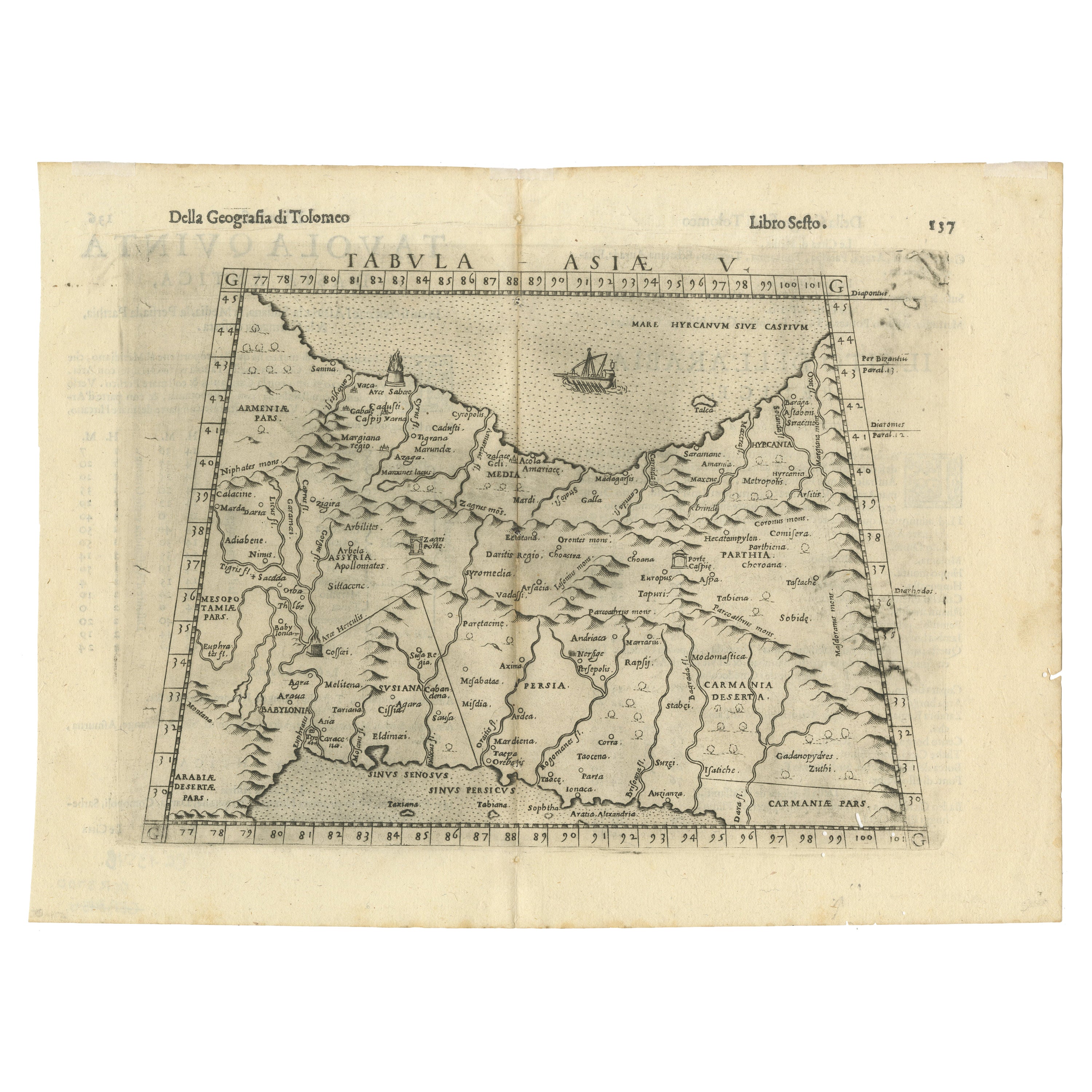
- Old Ptolemaic Map of the Region Between the Persian Gulf and Caspian Sea, 1598Located in Langweer, NL"Tabula Asiae V", Ptolemy/Ruscelli Subject: Persia - Iran Period: 1598 (published) Publication: Geografia di Claudio Tolomeo Allessadrino… Claudius Ptolemy was a mathematician, ast...Category
Antique 16th Century Maps
MaterialsPaper
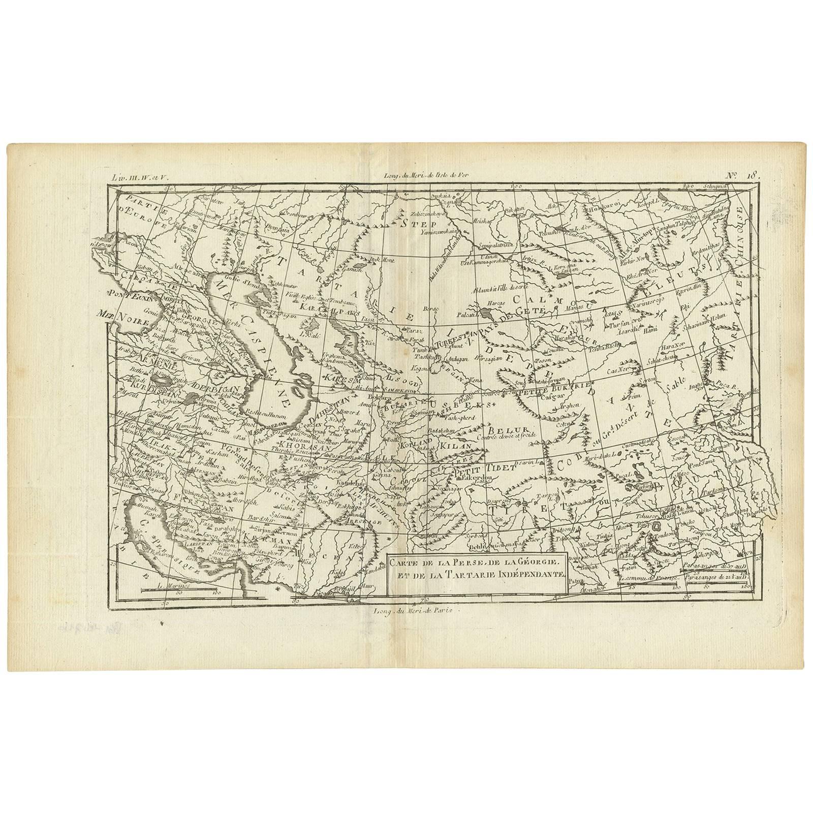
- Antique Map of the Persian Gulf and Caspian Sea Region by R. Bonne, 1780Located in Langweer, NLAntique print titled 'Carte de la Perse, de la Georgie, et de la Tartarie Independante'. Shows the region from the Persian Gulf and Caspian Sea in the wes...Category
Antique Late 18th Century Maps
MaterialsPaper
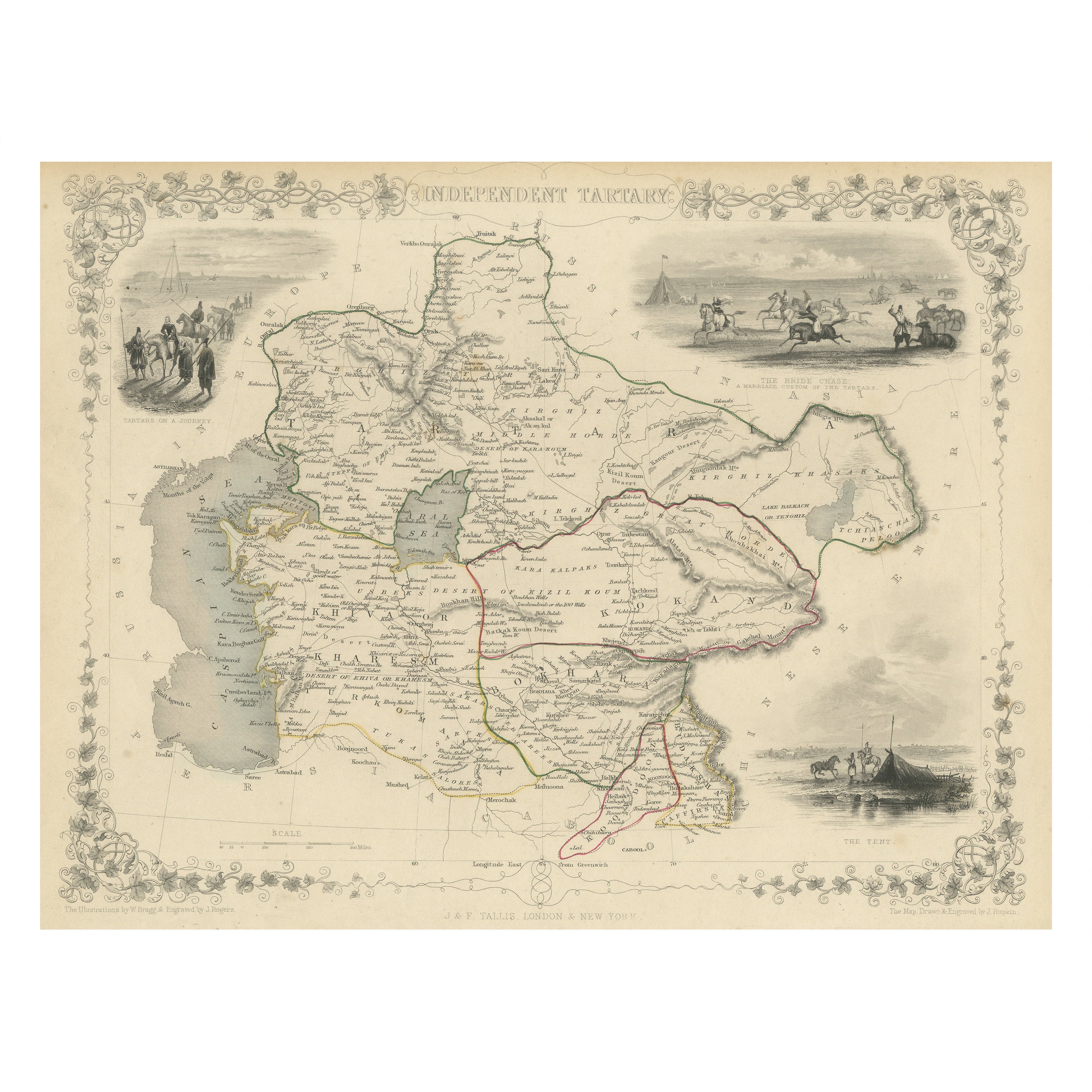
- Antique Map of Central Asia between the Caspian Sea and Lake BalkhashLocated in Langweer, NLAntique map titled 'Independent Tartary'. Original steel engraved map of Central Asia. It covers the regions between the Caspian Sea and Lake Balkhash and between Russia and Afghanis...Category
Antique Mid-19th Century Maps
MaterialsPaper
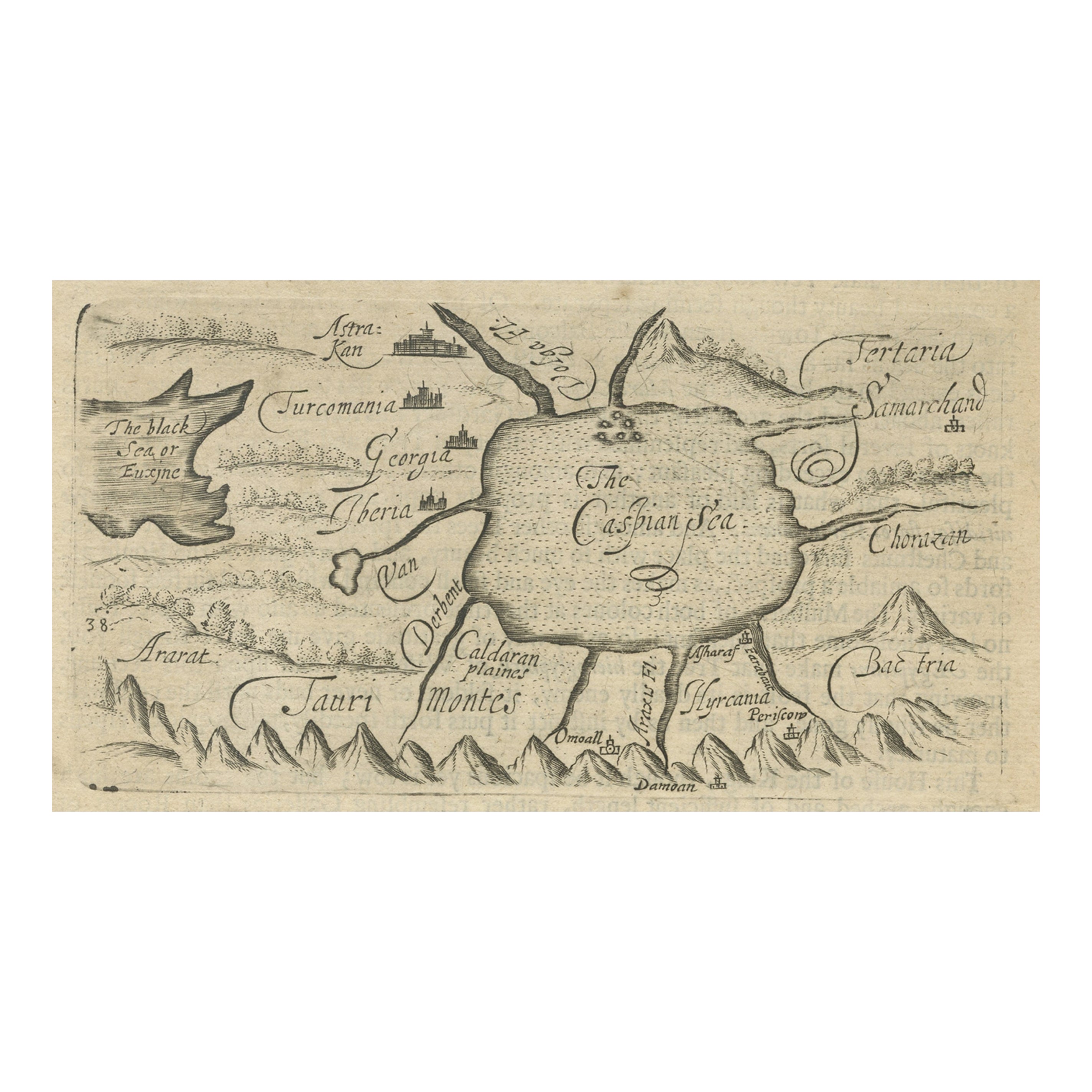
- Uncommon Miniature Map of the Region around the Caspian Sea, ca.1800Located in Langweer, NLUncommon miniature map of the region around the Caspian Sea. Including the black sea and several mountains. Source unknown, to be determined. Artist...Category
Antique Early 1800s Maps
MaterialsPaper
- Antique Map of the Caspian Sea and Surroundings by Bellin, 1764Located in Langweer, NLAntique map titled 'Carte de la Mer Caspienne et ses Environs'. Old map depicting the region of the Caspian Sea. This map originates from 'Le Petit Atlas M...Category
Antique 18th Century Maps
MaterialsPaper

You May Also Like
- The Normandy Region of France: A 17th C. Hand-colored Map by Sanson and JaillotBy Nicolas SansonLocated in Alamo, CAThis large hand-colored map entitled "Le Duché et Gouvernement de Normandie divisée en Haute et Basse Normandie en divers Pays; et par evêchez, avec le Gouvernement General du Havre ...Category
Antique 1690s French Maps
MaterialsPaper
- Super Rare Antique French Map of Chine and the Chinese Empire, 1780Located in Amsterdam, Noord HollandSuper Rare Antique French Map of Chine and the Chinese Empire, 1780 Very nice map of Asia. 1780 Made by Bonne. Additional information: Type: Map ...Category
Antique 18th Century European Maps
MaterialsPaper
- 1861 Topographical Map of the District of Columbia, by Boschke, Antique MapLocated in Colorado Springs, COPresented is an original map of Albert Boschke's extremely sought-after "Topographical Map of the District of Columbia Surveyed in the Years 1856 ...Category
Antique 1860s American Historical Memorabilia
MaterialsPaper
- Original Antique Map of China by Thomas Clerk, 1817Located in St Annes, LancashireGreat map of China Copper-plate engraving Drawn and engraved by Thomas Clerk, Edinburgh. Published by Mackenzie And Dent, 1817 Unframed.Category
Antique 1810s English Maps
MaterialsPaper
- 1594 Maurice Bouguereau Map of the Region Limoges, France, Ric0015Located in Norton, MA1594 Maurice Bouguereau map of the region Limoges, France, entitled "Totivs Lemovici et Confinium Pro Uinciarum Quantum ad Dioecefin Lemo Uicenfen Fpectant," Hand Colored Ric0015 Jean IV Le Clerc...Category
Antique 16th Century Dutch Maps
MaterialsPaper
- Original Antique Map of China, Arrowsmith, 1820Located in St Annes, LancashireGreat map of China Drawn under the direction of Arrowsmith Copper-plate engraving Published by Longman, Hurst, Rees, Orme and Brown, 1820 Unfr...Category
Antique 1820s English Maps
MaterialsPaper


Recently Viewed
View AllMore Ways To Browse
Chinese 39
Chinese Hundred Antiques
Toms Antique
Antique Tom
Antique Chinese 16th
16th Century Chinese Antiques
Chinese Antique Map
Antique Prints Of A Cross
Portuguese 16th
Pirate Furniture
Antique In Philippines
Victorian Book Ends
Denmark Map
18th Century Maps America
Pediment Metal
Map Hondius
Russian Antique Book
Map Of Egypt