Items Similar to Antique Map of the City of Visby 'Sweden' by F. Hogenberg, 1598

Want more images or videos?
Request additional images or videos from the seller
1 of 5
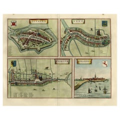
Antique Map of the City of Visby 'Sweden' by F. Hogenberg, 1598
$2,315.65
$2,894.5620% Off
£1,735.72
£2,169.6520% Off
€1,960
€2,45020% Off
CA$3,181.31
CA$3,976.6320% Off
A$3,551.63
A$4,439.5420% Off
CHF 1,861
CHF 2,326.2520% Off
MX$43,475.42
MX$54,344.2720% Off
NOK 23,634.72
NOK 29,543.4020% Off
SEK 22,284.54
SEK 27,855.6720% Off
DKK 14,920.24
DKK 18,650.2920% Off
About the Item
This is a wonderful bird's-eye plan/view of the oldest city in Sweden.
Visby, the largest city on the island of Gotland was an important Viking city and the main centre of the Hanseatic League in the Baltic from the 12th-14th century. The characteristic ringwall (Ringmuren) and protected harbour are well depicted. A key at bottom provides the locations of the major buildings.
Rare original map of the 16th century - professionally framed.
- Dimensions:Height: 23.04 in (58.5 cm)Width: 27.96 in (71 cm)Depth: 0.99 in (2.5 cm)
- Materials and Techniques:
- Period:
- Date of Manufacture:1598
- Condition:Good condition, frame included (some minor defects). Please study image carefully.
- Seller Location:Langweer, NL
- Reference Number:Seller: BG-071941stDibs: LU3054328313442
About the Seller
5.0
Recognized Seller
These prestigious sellers are industry leaders and represent the highest echelon for item quality and design.
Platinum Seller
Premium sellers with a 4.7+ rating and 24-hour response times
Established in 2009
1stDibs seller since 2017
2,513 sales on 1stDibs
Typical response time: <1 hour
- ShippingRetrieving quote...Shipping from: Langweer, Netherlands
- Return Policy
Authenticity Guarantee
In the unlikely event there’s an issue with an item’s authenticity, contact us within 1 year for a full refund. DetailsMoney-Back Guarantee
If your item is not as described, is damaged in transit, or does not arrive, contact us within 7 days for a full refund. Details24-Hour Cancellation
You have a 24-hour grace period in which to reconsider your purchase, with no questions asked.Vetted Professional Sellers
Our world-class sellers must adhere to strict standards for service and quality, maintaining the integrity of our listings.Price-Match Guarantee
If you find that a seller listed the same item for a lower price elsewhere, we’ll match it.Trusted Global Delivery
Our best-in-class carrier network provides specialized shipping options worldwide, including custom delivery.More From This Seller
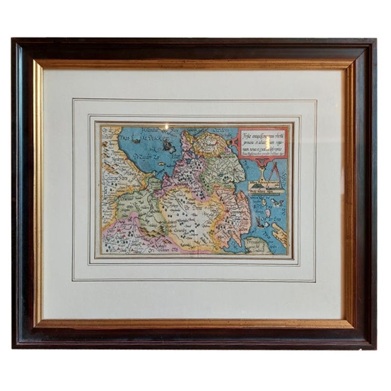
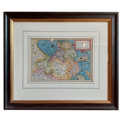
View AllAntique Map of Friesland by Bussemacher in Frame, c.1592
Located in Langweer, NL
Original antique map titled 'Frisiae Antiquissimae (..)'. Original antique map of Friesland. Published by J. Bussemacher, circa 1592. Artists and Engravers: Bussemacher was active as...
Category
Antique 18th Century Maps
Materials
Paper
$708 Sale Price
20% Off
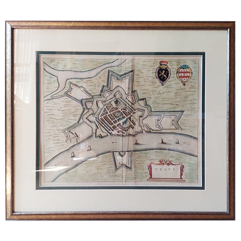
Antique Map of the City of Grave by Blaeu, 1649
Located in Langweer, NL
Antique map titled 'Grave'. Original antique map of the city of Grave, the Netherlands. Published by J. Blaeu, 1649.
Artists and Engravers: Joan Blaeu (23 September 1596 - 28 May...
Category
Antique 17th Century Maps
Materials
Paper

$661 Sale Price
20% Off
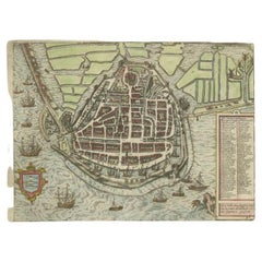
Antique Map of the City of Enkhuizen by Guicciardini, 1625
Located in Langweer, NL
Antique map titled 'Die Stadt Enchuijsen, La ville denchuijsen'. Map of Enkhuizen, Noord-Holland, The Netherlands. Oiginates from the 1625 edition of 'Discrittione di tutti i Paesi B...
Category
Antique 17th Century Maps
Materials
Paper
$288 Sale Price
20% Off
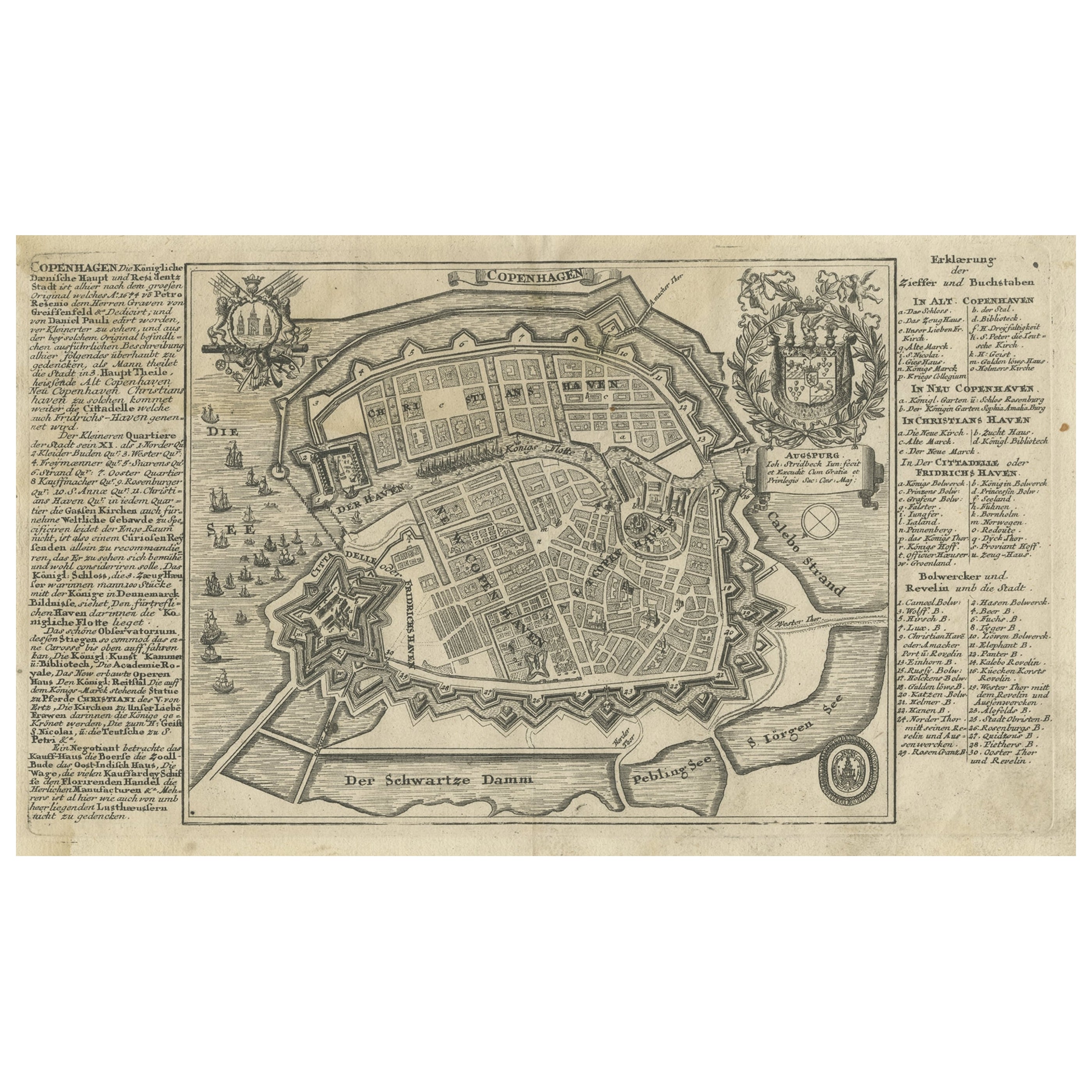
Antique Map of the City of Copenhagen in Denmark c.1720
Located in Langweer, NL
Antique map titled 'Copenhagen'. Original antique map of the city of Copenhagen, Denmark. This map originates from 'Unterschiedliche dieser Zeit Beruffene Laender, Gegenden, Staedte ...
Category
Antique 18th Century Danish Maps
Materials
Paper
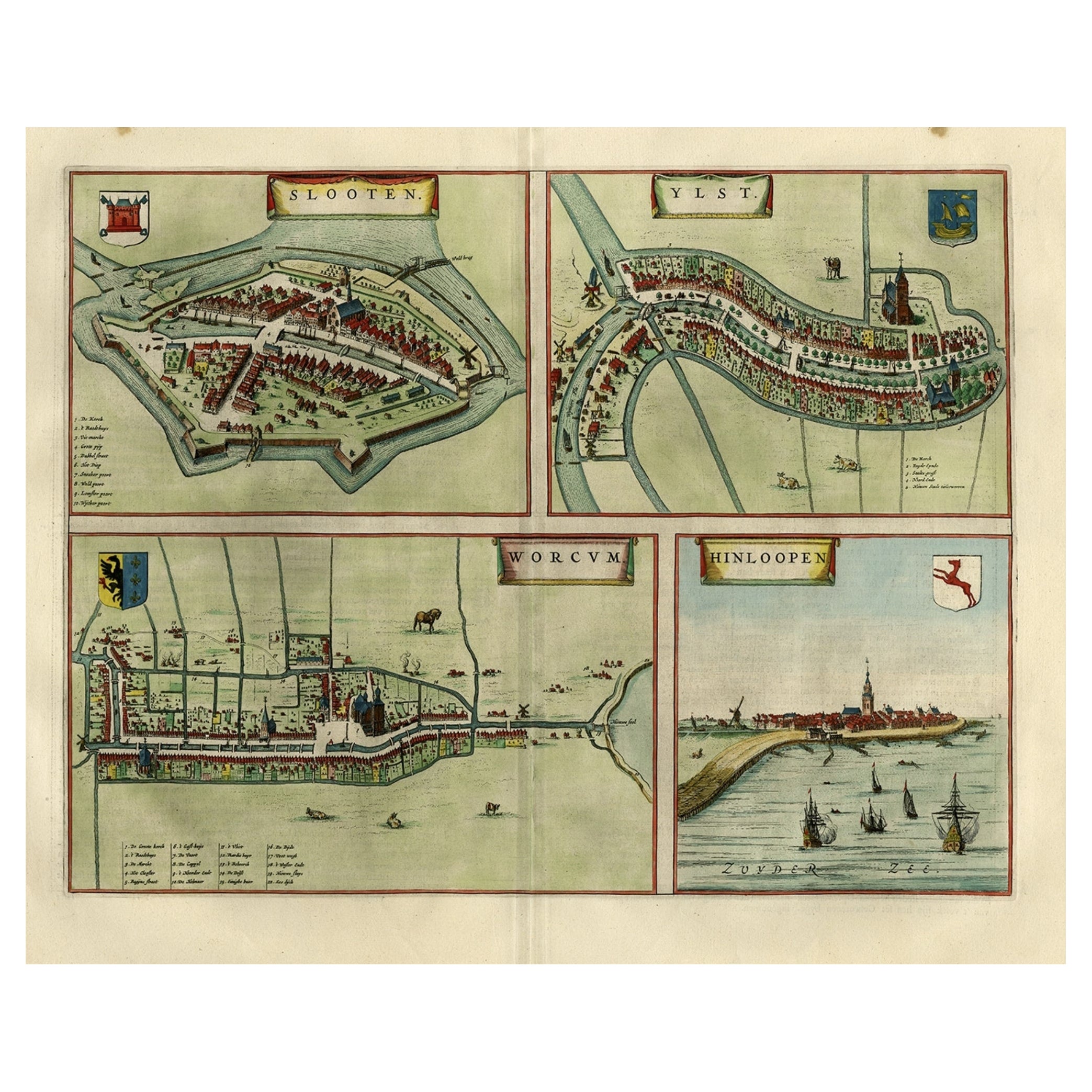
Antique Map of Frisian Cities Sloten, Ylst, Workum and Hindelopen by Blaeu, 1652
Located in Langweer, NL
Antique print titled 'Slooten - Ylst - Worcum - Hinloopen'. Three plans and a bird's eye view on one sheet. The plans show the Frisian cities Sloten, IJlst, Workum and the view shows...
Category
Antique 1650s Maps
Materials
Paper
$1,086 Sale Price
20% Off
Antique Map of the City of Kampen by Guicciardini, 1613
Located in Langweer, NL
Antique map titled 'Urbis Campensis (..)'. Plan of the city of Kampen, the Netherlands. This map originates from the 1613 edition of 'Discrittione di tutti i Paesi Bassi', by L. Guic...
Category
Antique 17th Century Maps
Materials
Paper

You May Also Like
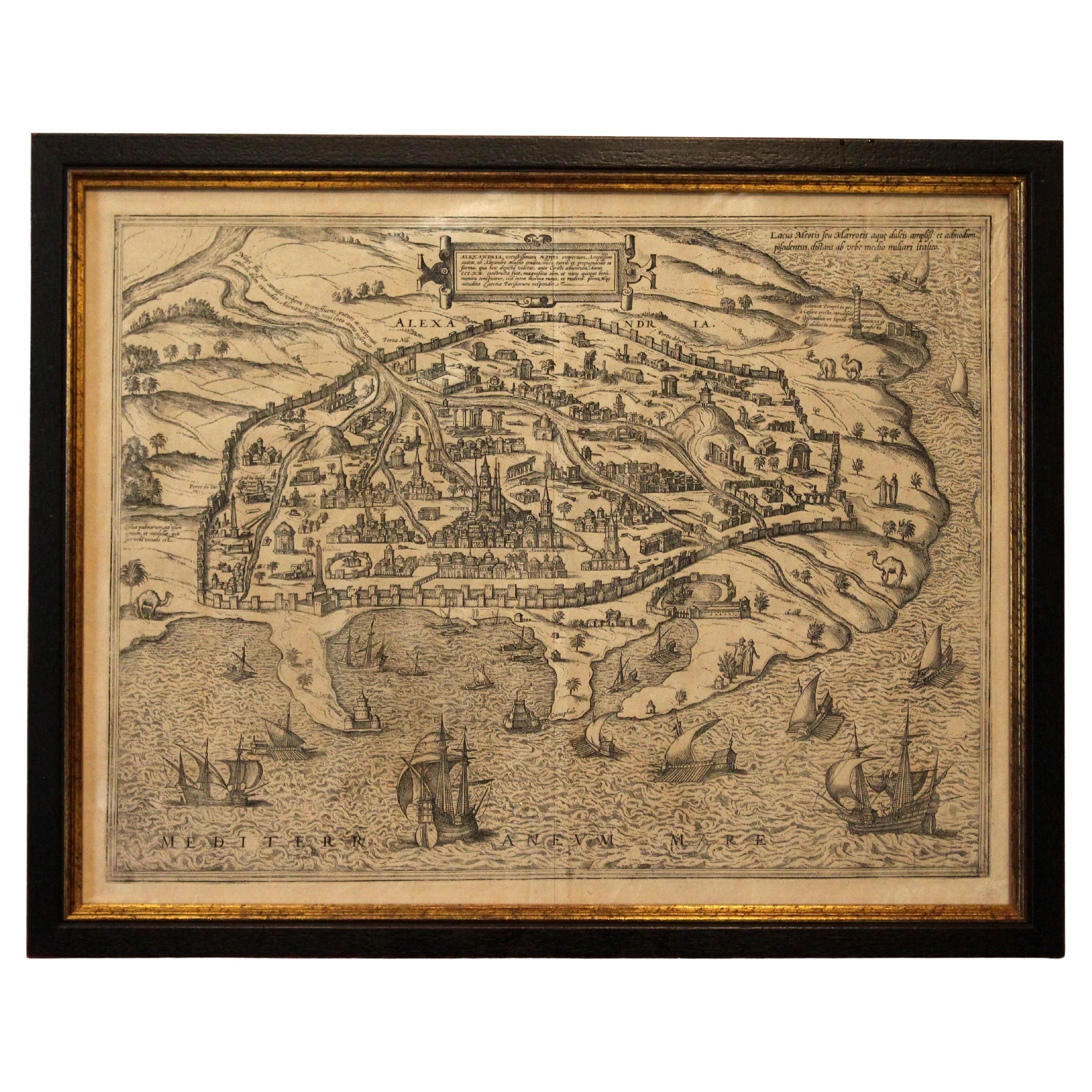
1597 German Map of Alexandria by Georg Braun and Frans Hogenberg
By Georg Braun and Frans Hogenberg
Located in Chapel Hill, NC
1597 Map of Alexandria by Georg Braun and Frans Hogenberg, Germany. From "Civitas Orbis Terrarum", part 2, published in Cologne by Bertram Buchholz. Printed in 2 parts. Title: "Alexa...
Category
Antique 16th Century German Renaissance Maps
Materials
Paper

17th Century Map of Denmark by French Cartographer Sanson, Dated 1658
By Nicolas Sanson
Located in Copenhagen, K
17th century map of Denmark by French cartographer Sanson.
Nicolas Sanson (20 December 1600-7 July 1667) was a French cartographer, termed by some the creator of French geography an...
Category
Antique 17th Century French Maps
Materials
Paper

1646 Jansson Map Entitled "Procinvia Connactiae, " Ric.a006
Located in Norton, MA
1646 Jansson map entitled
"Procinvia connactiae,"
Ric.a006
Description: The PROVINCE of CONNAVGT 490 x 380From vol 4 of Jansson's Atlas Novus 1646, published in Amsterdam with...
Category
Antique 17th Century Unknown Maps
Materials
Paper

The Holy Land at the Time of Jesus: A 17th Century Dutch Map by Visscher
By Nicolaes Visscher II
Located in Alamo, CA
This detailed Dutch map entitled "Het Beloofe de Landt Canaan door wandelt van onsen Salichmaecker Iesu Christo, nessens syne Apostelen" by Nicolaes Visscher was published in Amsterd...
Category
Antique Mid-17th Century Dutch Maps
Materials
Paper

Utrecht, Antique Map from "Civitates Orbis Terrarum"
By Franz Hogenberg
Located in Roma, IT
Braun G., Hogenberg F., Traiectum or Utrecht, from the collection Civitates Orbis Terrarum, Cologne, T. Graminaeus, 1572-1617.
Very fine B/W aquatint showing a view of Utrecht, with...
Category
16th Century Landscape Prints
Materials
Etching

19th Century Reprint of 16th Century Harbor Map of Copenhagen
Located in Haddonfield, NJ
This reprint of 1587 antique map of Copenhagen, Denmark retains its original mid-century mat and has been recently reframed in classic wood frame. The muted sepia colored map is a wo...
Category
Antique 1880s Danish Baroque Maps
Materials
Wood, Paper

More Ways To Browse
Caucasus Map
Map Of Puerto Rico
Nevada Antique Map
Shetland Map
Antique Chicago Maps
Kolkata Antique Furniture
Antique Bermuda Furniture
Antique Dairy Collectibles
Antique Map Of Cuba
Antique Map Of Yorkshire
Antique Map Vietnam
Antique Maps Massachusetts
Guyana Antique Map
Peninsular War
Santa Cruz Island
Ukraine Antique Map
Antique Life Buoy
Antique Map Nova Scotia