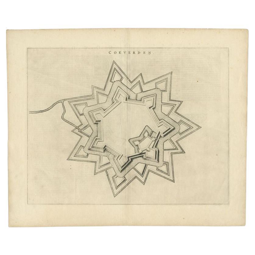
Items Similar to Antique Map of Coevorden in the Netherlands, 1691

Want more images or videos?
Request additional images or videos from the seller
1 of 5
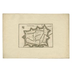
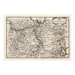
Antique Map of Coevorden in the Netherlands, 1691
$86.27
$107.8320% Off
£64.21
£80.2620% Off
€72
€9020% Off
CA$118.16
CA$147.7020% Off
A$131.42
A$164.2820% Off
CHF 68.63
CHF 85.7820% Off
MX$1,599.28
MX$1,999.1020% Off
NOK 876.45
NOK 1,095.5620% Off
SEK 821.95
SEK 1,027.4420% Off
DKK 548.11
DKK 685.1420% Off
Shipping
Retrieving quote...The 1stDibs Promise:
Authenticity Guarantee,
Money-Back Guarantee,
24-Hour Cancellation
About the Item
Plate 'Covorden.' (Plan of the fortified city of Coevorden, The Netherlands.) This attractive original old antique print / plate originates from: 'Ausführliche und grundrichtige Beschreibung der Freyvereinigten Staaten und Spannischen Niederlanden, in gewisse und sonderbare XVII Länder abgetheilet.', published by C. Riegel, Frankfurt, Leipzig, 1691.
Artists and Engravers: Published by Christoff Riegel (?-1714), the famous publisher from Nuremberg, Germany with branches in Frankfurt and Leipzig.
Condition: Good. General age related toning. Please study image carefully.
Date: 1691
Overall size: 13 x 7 cm.
Image size: 11 x 6 cm.
We sell original antique maps to collectors, historians, educators and interior decorators all over the world. Our collection includes a wide range of authentic antique maps from the 16th to the 20th centuries. Buying and collecting antique maps is a tradition that goes back hundreds of years. Antique maps have proved a richly rewarding investment over the past decade, thanks to a growing appreciation of their unique historical appeal. Today the decorative qualities of antique maps are widely recognized by interior designers who appreciate their beauty and design flexibility. Depending on the individual map, presentation, and context, a rare or antique map can be modern, traditional, abstract, figurative, serious or whimsical. We offer a wide range of authentic antique maps for any budget.
- Dimensions:Height: 2.76 in (7 cm)Width: 5.12 in (13 cm)Depth: 0 in (0.01 mm)
- Materials and Techniques:
- Period:
- Date of Manufacture:1691
- Condition:
- Seller Location:Langweer, NL
- Reference Number:Seller: PCT-150951stDibs: LU3054329642432
About the Seller
5.0
Recognized Seller
These prestigious sellers are industry leaders and represent the highest echelon for item quality and design.
Platinum Seller
Premium sellers with a 4.7+ rating and 24-hour response times
Established in 2009
1stDibs seller since 2017
2,502 sales on 1stDibs
Typical response time: <1 hour
- ShippingRetrieving quote...Shipping from: Langweer, Netherlands
- Return Policy
Authenticity Guarantee
In the unlikely event there’s an issue with an item’s authenticity, contact us within 1 year for a full refund. DetailsMoney-Back Guarantee
If your item is not as described, is damaged in transit, or does not arrive, contact us within 7 days for a full refund. Details24-Hour Cancellation
You have a 24-hour grace period in which to reconsider your purchase, with no questions asked.Vetted Professional Sellers
Our world-class sellers must adhere to strict standards for service and quality, maintaining the integrity of our listings.Price-Match Guarantee
If you find that a seller listed the same item for a lower price elsewhere, we’ll match it.Trusted Global Delivery
Our best-in-class carrier network provides specialized shipping options worldwide, including custom delivery.More From This Seller
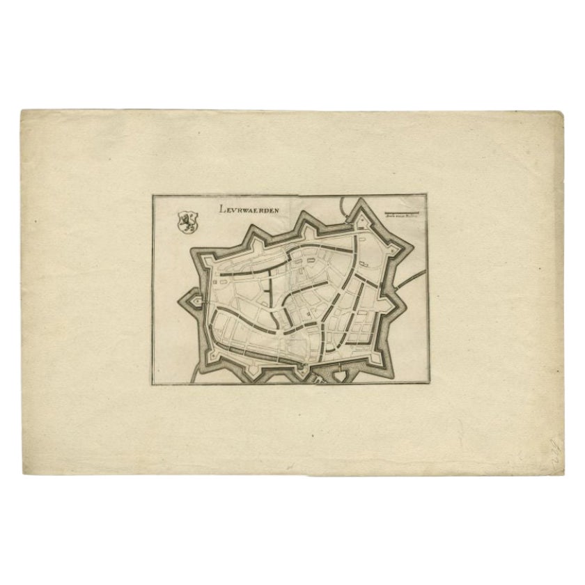
View AllAntique Map of the City of Leeuwarden by Merian, 1659
Located in Langweer, NL
Antique map titled 'Leurwaerden'. This print depicts the city of Leeuwarden (Friesland, The Netherlands). This print originates from 'Topographia Germaniae Inferioris (..)' by C. Mer...
Category
Antique 17th Century Maps
Materials
Paper
$76 Sale Price
20% Off
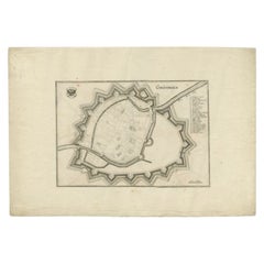
Antique Map of the City of Coevorden by Blaeu, 1649
Located in Langweer, NL
Antique map titled 'Coeverden'. Original map of the city of Coevorden, the Netherlands. This map originates from 'Novum Ac Magnum Theatrum Urbium Belgicae Liberae Ac Foederatae' publ...
Category
Antique 17th Century Maps
Materials
Paper
$217 Sale Price
20% Off
Antique Map of the Province of Friesland in The Netherlands, 1718
Located in Langweer, NL
Antique map titled 'Frisiae Dominium vernacule Friesland (..)'.
Original antique map of Friesland, the Netherlands. Originates from 'Uitbeelding van de Heerlijkheid van Friesland...
Category
Antique 18th Century Maps
Materials
Paper

$718 Sale Price
20% Off
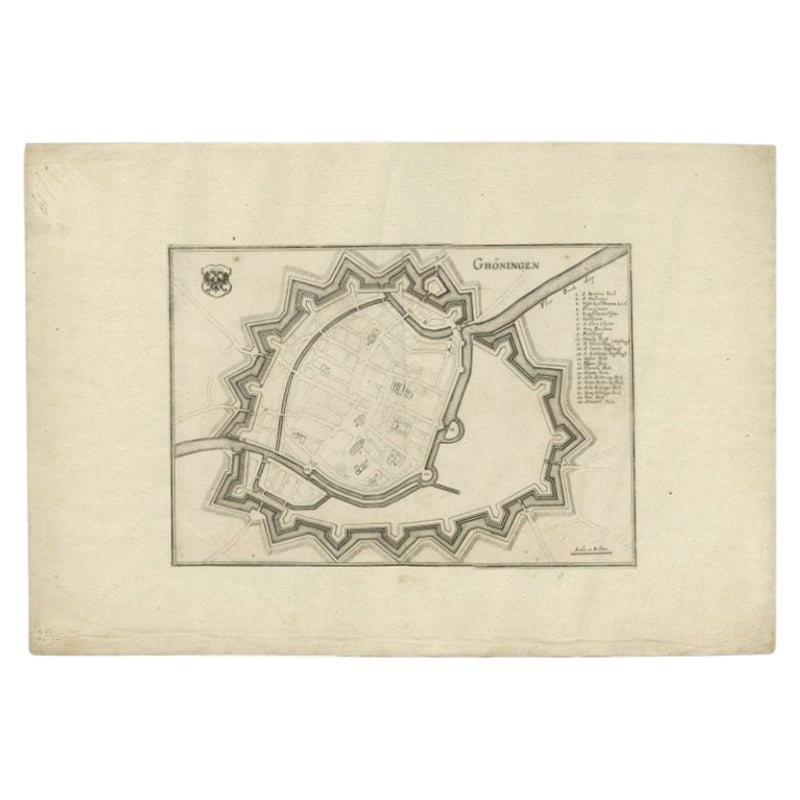
Antique Map of the City of Groningen by Merian, 1659
Located in Langweer, NL
Antique map titled 'Gröningen'. This print depicts the city of Groningen, the Netherlands. This print originates from 'Topographia Germaniae Inferioris (..)' by C. Merian.
Artist...
Category
Antique 17th Century Maps
Materials
Paper
$88 Sale Price
20% Off
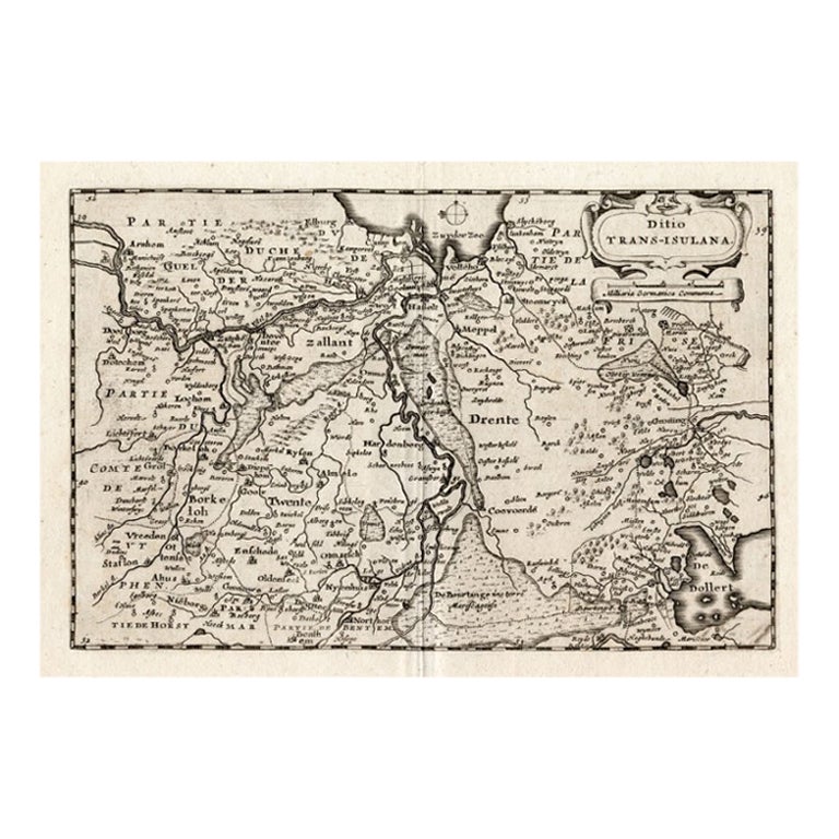
Antique Map of Overijssel by Colom, 1635
Located in Langweer, NL
Antique map titled 'Ditio Trans-Isulana'. Original antique map of the province of Overijssel, the Netherlands. This map originates from 'Vyerige Colom verthonende de 17 Nederlandsche...
Category
Antique 17th Century Maps
Materials
Paper
$210 Sale Price
20% Off
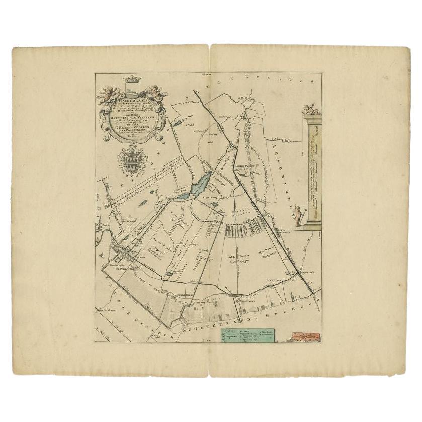
Antique Map of the Haskerland Township 'Friesland' by Halma, 1718
Located in Langweer, NL
Antique map Friesland titled 'Haskerland, de vierde Grietenije van de Zevenwolden (..)'. Old map of Friesland, the Netherlands. This map depicts the region of Haskerland and includes...
Category
Antique 18th Century Maps
Materials
Paper
$340 Sale Price
20% Off
You May Also Like
Original Antique Map of Switzerland, Engraved By Barlow, Dated 1807
Located in St Annes, Lancashire
Great map of Switzerland
Copper-plate engraving by Barlow
Published by Brightly & Kinnersly, Bungay, Suffolk.
Dated 1807
Unframed.
Category
Antique Early 1800s English Maps
Materials
Paper

1633 Map "La Souverainete De Sedan Et De Raucourt, Et La Prevoste Ric0011
Located in Norton, MA
1653 map entitled
"La Souverainete de Sedan et de Raucourt, et la Prevoste de Doncheri,"
Ric0011
Description:
Lovely map centered on Sedan and Doncheri and the Meuze River fr...
Category
Antique 17th Century Dutch Maps
Materials
Paper

1752 Vaugoundy Map of Flanders : Belgium, France, and the Netherlands, Ric.a002
Located in Norton, MA
Large Vaugoundy Map of Flanders:
Belgium, France, and the Netherlands
Colored -1752
Ric.a002
Description: This is a 1752 Didier Robert de Vaugondy map of Flanders. The map de...
Category
Antique 17th Century Unknown Maps
Materials
Paper

Map of the Netherlands - Etching by G. Braun and F. Hogenberg -Late 16th Century
By Franz Hogenberg
Located in Roma, IT
Map of the Netherlands is an original etching realized by George Braun and Franz Hogenberg, as part of the "Civitates Orbis Terrarum".
The “Civitates Orbis Terrarum” (Atlas of Citi...
Category
16th Century Figurative Prints
Materials
Etching

1643 Willem&Joan Blaeu Map NW Flanders "Flandriae Teutonicae Pars Prientalior
Located in Norton, MA
1643 Willem and Joan Blaeu map of northwest Flanders, entitled
"Flandriae Teutonicae Pars Prientalior,"
Ric0012
" Authentic" - Map of the northwest Fl...
Category
Antique 17th Century Dutch Maps
Materials
Paper

Antique County Map of Cheshire, Dutch, Framed, Cartography, Janssonius, C.1660
Located in Hele, Devon, GB
This is an antique county map of Cheshire. A Dutch, framed atlas engraving by Johannes Janssonius, dating to the 17th century and later.
A treat for the collector or county native,...
Category
Antique Mid-17th Century Dutch Charles II Maps
Materials
Glass, Wood, Paper

More Ways To Browse
Tunisia Antique Map
Antique Map New Orleans
Antique Maps Of Maryland
Gambia Antique Map
Antique Manitoba
Antique Map Of Brooklyn
Antique Map Of Michigan
Cham Antiques
Map Of Native American Tribes
Antique Furniture Halifax Furniture
Antique Furniture Trinidad
Antique Kiel Furniture
Cornwall Map
Marie Galante
Patagonia Map
Shepherd And Hedger
Vignola Furniture
Washington Dc Map