Items Similar to Antique Map of Deventer in the Netherlands, 1691


Want more images or videos?
Request additional images or videos from the seller
1 of 5
Antique Map of Deventer in the Netherlands, 1691
$124.61
$155.7620% Off
£92.74
£115.9320% Off
€104
€13020% Off
CA$170.68
CA$213.3520% Off
A$189.83
A$237.2920% Off
CHF 99.13
CHF 123.9120% Off
MX$2,310.08
MX$2,887.5920% Off
NOK 1,265.98
NOK 1,582.4820% Off
SEK 1,187.27
SEK 1,484.0820% Off
DKK 791.72
DKK 989.6420% Off
Shipping
Retrieving quote...The 1stDibs Promise:
Authenticity Guarantee,
Money-Back Guarantee,
24-Hour Cancellation
About the Item
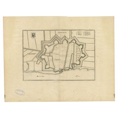
Plate 'Devendr.' (Plan of the fortified city of Deventer, The Netherlands.) This attractive original old antique print / plate originates from: 'Ausführliche und grundrichtige Beschreibung der Freyvereinigten Staaten und Spannischen Niederlanden, in gewisse und sonderbare XVII Länder abgetheilet.', published by C. Riegel, Frankfurt, Leipzig, 1691.
Artists and Engravers: Published by Christoff Riegel (?-1714), the famous publisher from Nuremberg, Germany with branches in Frankfurt and Leipzig.
Condition: Good, general age-related toning. Please study image carefully.
Date: 1691
Overall size: 13 x 7 cm.
Image size: 11 x 6 cm.
We sell original antique maps to collectors, historians, educators and interior decorators all over the world. Our collection includes a wide range of authentic antique maps from the 16th to the 20th centuries. Buying and collecting antique maps is a tradition that goes back hundreds of years. Antique maps have proved a richly rewarding investment over the past decade, thanks to a growing appreciation of their unique historical appeal. Today the decorative qualities of antique maps are widely recognized by interior designers who appreciate their beauty and design flexibility. Depending on the individual map, presentation, and context, a rare or antique map can be modern, traditional, abstract, figurative, serious or whimsical. We offer a wide range of authentic antique maps for any budget.
- Dimensions:Height: 2.76 in (7 cm)Width: 5.12 in (13 cm)Depth: 0 in (0.01 mm)
- Materials and Techniques:
- Period:
- Date of Manufacture:1691
- Condition:
- Seller Location:Langweer, NL
- Reference Number:Seller: PCT-151331stDibs: LU3054329642792
About the Seller
5.0
Recognized Seller
These prestigious sellers are industry leaders and represent the highest echelon for item quality and design.
Platinum Seller
Premium sellers with a 4.7+ rating and 24-hour response times
Established in 2009
1stDibs seller since 2017
2,508 sales on 1stDibs
Typical response time: <1 hour
- ShippingRetrieving quote...Shipping from: Langweer, Netherlands
- Return Policy
Authenticity Guarantee
In the unlikely event there’s an issue with an item’s authenticity, contact us within 1 year for a full refund. DetailsMoney-Back Guarantee
If your item is not as described, is damaged in transit, or does not arrive, contact us within 7 days for a full refund. Details24-Hour Cancellation
You have a 24-hour grace period in which to reconsider your purchase, with no questions asked.Vetted Professional Sellers
Our world-class sellers must adhere to strict standards for service and quality, maintaining the integrity of our listings.Price-Match Guarantee
If you find that a seller listed the same item for a lower price elsewhere, we’ll match it.Trusted Global Delivery
Our best-in-class carrier network provides specialized shipping options worldwide, including custom delivery.More From This Seller
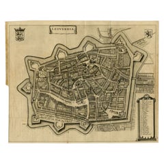
View AllAntique Map of Leeuwarden, Capital of Friesland, the Netherlands, by Blaeu, 1649
Located in Langweer, NL
Antique map titled 'Leoverdia.'
Bird's-eye view plan of Leeuwarden, Friesland, the Netherlands. With key to locations and coats of arms. Text in Dutch on verso.
This plan origina...
Category
Antique 17th Century Maps
Materials
Paper

$910 Sale Price
20% Off
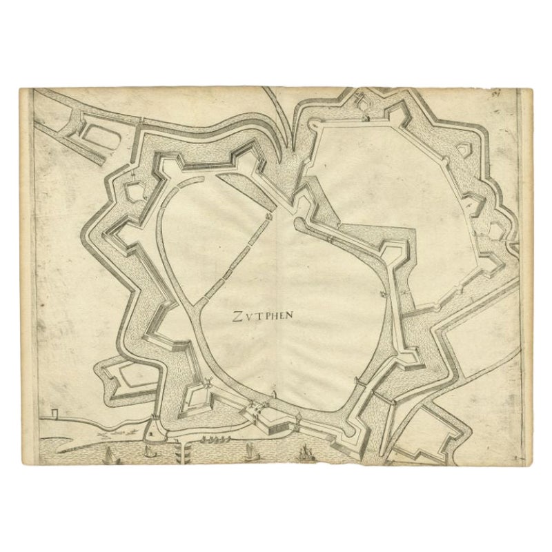
Antique Map of the City of Zutphen, c.1650
Located in Langweer, NL
Antique map titled 'Zutphen'. Uncommon original antique map of the city of Zutphen, the Netherlands. Source unknown, to be determined.
Artists and Engravers: Anonymous.
Conditi...
Category
Antique 17th Century Maps
Materials
Paper
$224 Sale Price
20% Off
Antique Map of the City of Alkmaar by Merian, 1659
Located in Langweer, NL
Antique map titled 'Alckmaer'. This print depicts the city of Alkmaar (The Netherlands). This print originates from 'Topographia Germaniae Inferioris (..)' by C. Merian. Artists and ...
Category
Antique 17th Century Maps
Materials
Paper
$94 Sale Price
20% Off
Antique Map of the City of Leeuwarden by Leti, 1690
Located in Langweer, NL
Antique map titled 'Leovardia.' A plan of Leeuwarden in Friesland, the Netherlands. With two coats of arms, the title in a scroll and an index of 30 buildings in the lower right. Fro...
Category
Antique 17th Century Maps
Materials
Paper
$640 Sale Price
20% Off
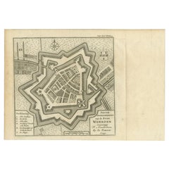
Antique Map of the City of Woerden by Tirion, c.1750
Located in Langweer, NL
Antique map titled 'Nieuwe Grondtekening van de Stad Woerden'. Plan of the city of Woerden, the Netherlands. Published circa 1750.
Artists and Engravers: Published by I. Tirion. ...
Category
Antique 18th Century Maps
Materials
Paper
$119 Sale Price
20% Off
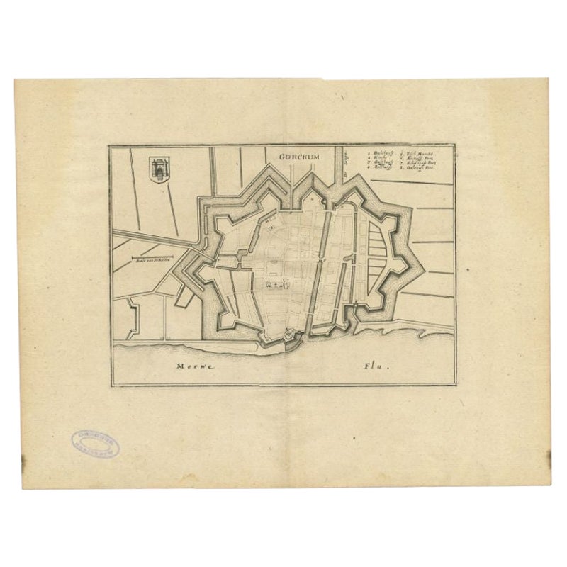
Antique Map of the City of Gorinchem by Merian, 1659
Located in Langweer, NL
Antique map titled 'Gorckum'. This print depicts the city of Gorinchem (or Gorcum/Gorkum, The Netherlands). This print originates from 'Topographia Germaniae Inferioris (..)' by C. M...
Category
Antique 17th Century Maps
Materials
Paper
$94 Sale Price
20% Off
You May Also Like
18th Century Map Engraving - Newport, a Strong Sea-Port Town in Flanders
Located in Corsham, GB
A map of Nieuwpoort, anglicised to 'Newport', in northern Belgium. There is a panorama in the upper quarter depicting major landmarks. Below is a plan of the town, including its strong defences and ships at the port in the lower register. Inscribed with the title in plate to the lower edge, 'Newport a Strong Sea-Port Town...
Category
18th Century More Prints
Materials
Engraving

$269 Sale Price
20% Off
1752 Vaugoundy Map of Flanders : Belgium, France, and the Netherlands, Ric.a002
Located in Norton, MA
Large Vaugoundy Map of Flanders:
Belgium, France, and the Netherlands
Colored -1752
Ric.a002
Description: This is a 1752 Didier Robert de Vaugondy map of Flanders. The map de...
Category
Antique 17th Century Unknown Maps
Materials
Paper

18th Century Map Engraving - Mechlin, or Malines
Located in Corsham, GB
A map of Mechelen, known as Malines in French and Mechlin in English, a city and municipality in the province of Antwerp in the Flemish Region of Belgium. A birds-eye view plan of th...
Category
18th Century More Prints
Materials
Engraving

$269 Sale Price
20% Off
17th Century Toulouse, Savve, Sommieres Topographical Map by Iohan Peeters
Located in New York, NY
Fine topographical 17th century map of Toulouse, Savve and Sommieres by Iohan Peeters
Beautiful engraving of the capital of France's Occitanie Region, Toulouse, called La Ville Rose- the Pink City, for the terracotta bricks used in its many buildings, giving the city a distinct apricot-rose hue. An important cultural and educational center, the city's residents included Nobel Prize winners and world renown artists- Henri de Toulouse-Lautrec, Henri Martin, Jean-Auguste-Dominique Ingres, Antonin Mercie, Alexandre Falguiere and more recently Cyril Kongo...
Category
Antique 17th Century Dutch Maps
Materials
Paper

Map of the Netherlands - Etching by G. Braun and F. Hogenberg -Late 16th Century
By Franz Hogenberg
Located in Roma, IT
Map of the Netherlands is an original etching realized by George Braun and Franz Hogenberg, as part of the "Civitates Orbis Terrarum".
The “Civitates Orbis Terrarum” (Atlas of Citi...
Category
16th Century Figurative Prints
Materials
Etching

Utrecht, Netherlands: A Large 17th Century Hand-colored Map by Sanson & Jaillot
By Nicholas Sanson d'Abbeville
Located in Alamo, CA
This large hand-colored map entitled "La Seigneurie d'Utrecht. Dressé sur les memoires les plus nouveaux par le Sr. Sanson" was originally created by Nicholas Sanson d'Abbeville. Thi...
Category
1690s Landscape Prints
Materials
Engraving

More Ways To Browse
Tunisia Antique Map
Antique Map New Orleans
Antique Maps Of Maryland
Gambia Antique Map
Antique Manitoba
Antique Map Of Brooklyn
Antique Map Of Michigan
Cham Antiques
Map Of Native American Tribes
Antique Furniture Halifax Furniture
Antique Furniture Trinidad
Antique Kiel Furniture
Cornwall Map
Marie Galante
Patagonia Map
Shepherd And Hedger
Vignola Furniture
Washington Dc Map