Items Similar to Antique Map of the City of Leeuwarden by Leti, 1690

Want more images or videos?
Request additional images or videos from the seller
1 of 5
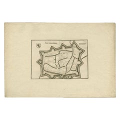
Antique Map of the City of Leeuwarden by Leti, 1690
About the Item
Antique map titled 'Leovardia.' A plan of Leeuwarden in Friesland, the Netherlands. With two coats of arms, the title in a scroll and an index of 30 buildings in the lower right. From Gregorio Leti's ""Teatro Belgico"", Amsterdam: Willem de Jonge, 1690. These maps were originally used in a Janssonius atlas, and are therefore folded multiple times to fit the smaller size Leti edition. Consequently, the maps are also printed on thinner paper. Ref: Koeman (IV) 2244 42:2A (1690 Leti Teatro Belg.)
Artists and Engravers: Cartographer: Johannes Janssonius. Johannes Janssonius also known as Jan Jansson was born 1588 in Arnhem, Netherlands. His father was a bookseller and publisher (Jan Janszoon the Elder). When he married the daughter of the cartographer Jodocus Hondius he also set up a business as book publisher in Amsterdam. His first map was published in 1616. Around 15 years later he set up a partnership with his brother in law Hondius add issued further editions of the Mercator/Hondius atlas. After his death in 1664, his heirs still have published several maps. Many of his plates have been acquired by Pieter Schenk and Gerard Valk. Salomon Savery (1594-1683) was an engraver from the Northern Netherlands.
Condition: Good, given age. Original folds, as issued. Some faint soiling in the image, especially in the right edge. Left margin uneven from binding. A small wormhole in the image (repeated three times as a result of folding). General age-related toning and/or occasional minor defects from handling. Blank verso. Please study image carefully.
Date: 1690
Overall size: 52.2 x 42.2 cm.
Image size: 50.3 x 40 cm.
We sell original antique maps to collectors, historians, educators and interior decorators all over the world. Our collection includes a wide range of authentic antique maps from the 16th to the 20th centuries. Buying and collecting antique maps is a tradition that goes back hundreds of years. Antique maps have proved a richly rewarding investment over the past decade, thanks to a growing appreciation of their unique historical appeal. Today the decorative qualities of antique maps are widely recognized by interior designers who appreciate their beauty and design flexibility. Depending on the individual map, presentation, and context, a rare or antique map can be modern, traditional, abstract, figurative, serious or whimsical. We offer a wide range of authentic antique maps for any budget.
- Dimensions:Height: 16.62 in (42.2 cm)Width: 20.56 in (52.2 cm)Depth: 0 in (0.01 mm)
- Materials and Techniques:
- Period:
- Date of Manufacture:1690
- Condition:
- Seller Location:Langweer, NL
- Reference Number:
About the Seller
5.0
Platinum Seller
These expertly vetted sellers are 1stDibs' most experienced sellers and are rated highest by our customers.
Established in 2009
1stDibs seller since 2017
1,929 sales on 1stDibs
Typical response time: <1 hour
- ShippingRetrieving quote...Ships From: Langweer, Netherlands
- Return PolicyA return for this item may be initiated within 14 days of delivery.
More From This SellerView All
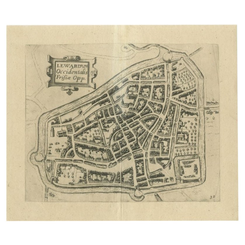
- Antique Map of the City of Leeuwarden by Guicciardini, 1613Located in Langweer, NLAntique map tited 'Lewardum'. Plan of the city of Leeuwarden, Friesland, the Netherlands. This map originates from the 1613 edition of 'Discrittione di tutti i Paesi Bassi', by L. Gu...Category
Antique 17th Century Maps
MaterialsPaper
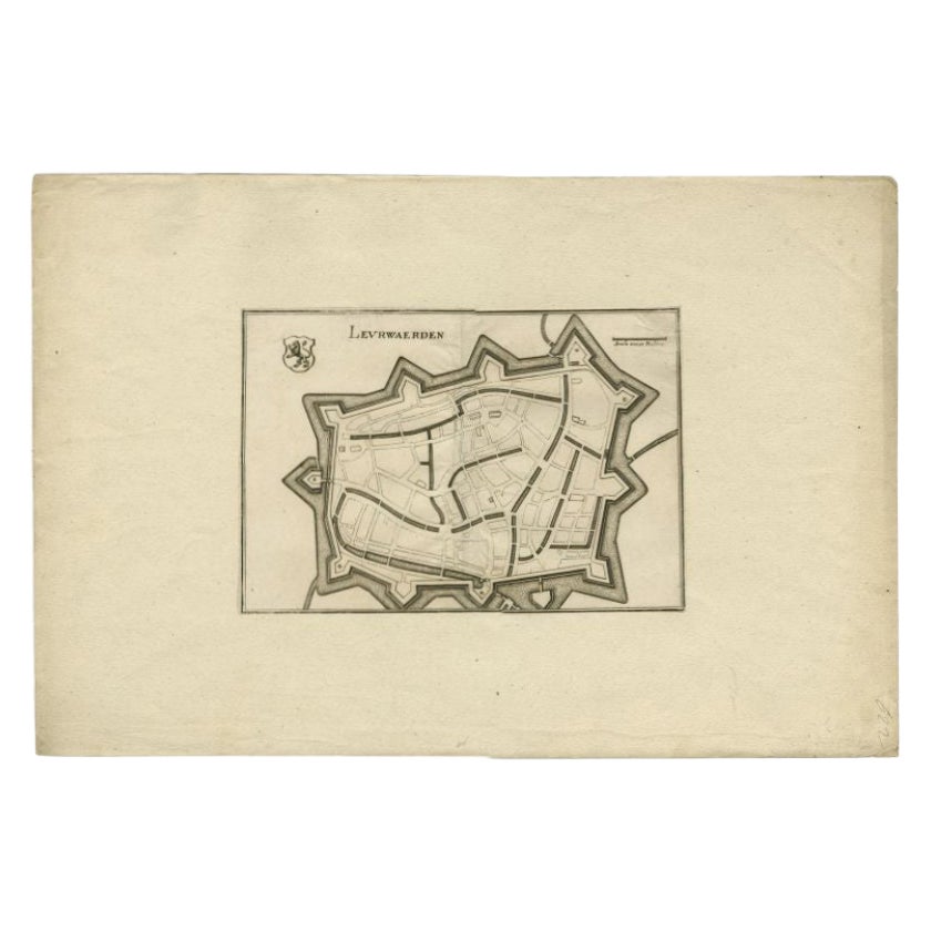
- Antique Map of the City of Leeuwarden by Merian, 1659Located in Langweer, NLAntique map titled 'Leurwaerden'. This print depicts the city of Leeuwarden (Friesland, The Netherlands). This print originates from 'Topographia Germaniae Inferioris (..)' by C. Mer...Category
Antique 17th Century Maps
MaterialsPaper
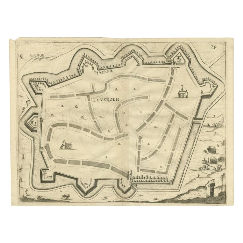
- Antique Map of the City of Leeuwarden by Priorato, 1673Located in Langweer, NLAntique map titled 'Leverden'. This map depicts the city of Leeuwarden (Friesland, The Netherlands). This original antique print originates from 'Teatro del Belgio (…)', published in...Category
Antique 17th Century Maps
MaterialsPaper
- Antique Map of the City of Leeuwarden by Merian, 1659Located in Langweer, NLAntique map titled 'Leurwaerden'. This print depicts the city of Leeuwarden (Friesland, The Netherlands). This print originates from 'Topographia Germaniae Inferioris (..)' by C. Mer...Category
Antique 17th Century Maps
MaterialsPaper
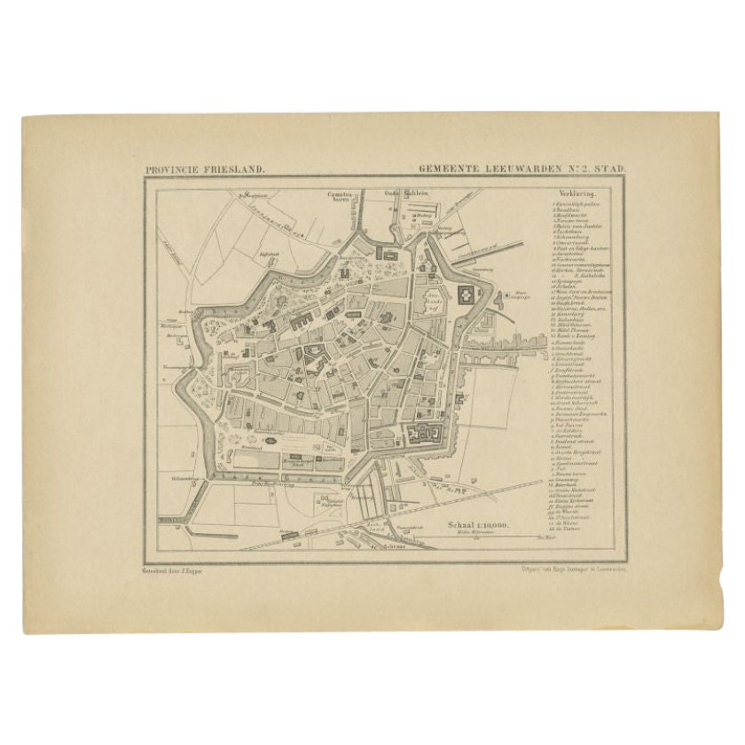
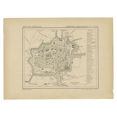
- Antique Map of the City of Leeuwarden by Kuyper, 1868Located in Langweer, NLAntique map titled 'Provincie Friesland - Gemeente Leeuwarden No. 2 Stad'. Map of the city of Leeuwarden, Friesland. This map originates from 'Gemeente-Atlas van Nederland' by J. Kuy...Category
Antique 19th Century Maps
MaterialsPaper
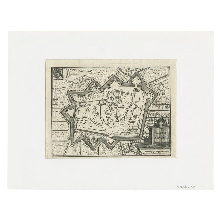
- Antique Map of the City of Leeuwarden by Christyn, 1785Located in Langweer, NLAntique map titled 'La Ville de Lewarde'. Old map of the city of Leeuwarden, Friesland. Originates from 'Les Délices des Pays-Bas' by J.B. Christyn. Artists and Engravers: Author:...Category
Antique 18th Century Maps
MaterialsPaper

You May Also Like
- 1840 Map of the City of Washington Published by William M. MorrisonLocated in Colorado Springs, COThis map, printed in 1840, is a detailed representation of Washington, D.C. in the mid-19th century. The map shows block numbers, wards, and government buildings as well as details o...Category
Antique 1840s American Federal Maps
MaterialsPaper
- 1861 Topographical Map of the District of Columbia, by Boschke, Antique MapLocated in Colorado Springs, COPresented is an original map of Albert Boschke's extremely sought-after "Topographical Map of the District of Columbia Surveyed in the Years 1856 ...Category
Antique 1860s American Historical Memorabilia
MaterialsPaper
- Antique Map of American Cities, Vignette of New York City, circa 1920Located in St Annes, LancashireGreat maps of American Cities Unframed Original color By John Bartholomew and Co. Edinburgh Geographical Institute Published, circa 1920Category
Vintage 1920s British Maps
MaterialsPaper
- Original Antique Map / City Plan of Brussels by Tallis, circa 1850Located in St Annes, LancashireGreat map of Brussels. Steel engraving. Published by London Printing & Publishing Co. (Formerly Tallis), C.1850 Free shipping.Category
Antique 1850s English Maps
MaterialsPaper
- Italian Parchment Map of the City of Lucca Dated 1640By Matthäus Merian the ElderLocated in Roma, ITAn antique map of the Tuscan city of Lucca engraved for The 'Itinerarium Italiæ Nov-antiquæ' by Matthäus Merian the Elder and printed in 1640...Category
Antique 1640s Italian Maps
MaterialsParchment Paper, Paper
- Italian Parchment Map of the City of Pisa Dated, 1640By Matthäus Merian the ElderLocated in Roma, ITAn antique map of the Tuscan city of Pisa engraved for The 'Itinerarium Italiæ Nov-antiquæ' by Matthäus Merian the Elder and printed in 1640....Category
Antique 1640s Italian Maps
MaterialsPaper


Recently Viewed
View AllMore Ways To Browse
Coat Of Arms Plates
Antique Furniture Building Plans
Mercator Map
Antique Map Set
Set Of Antique Maps
Map Hondius
Amsterdam Coat Of Arms
Map Print Set
Antique Map Schenk
Scroll Map
Compass Antique Map
Antique Compass Map
Antique Russian Wood Furniture
Antique Russian Wood
Antique Map Britain
Antique Map China
Antique China Map
Antique Chinese Maps