Items Similar to Antique Map of the Environs of Cap-Français, Saint-Domingue, c.1760


Want more images or videos?
Request additional images or videos from the seller
1 of 10
Antique Map of the Environs of Cap-Français, Saint-Domingue, c.1760
$521.50
£388.25
€440
CA$718.55
A$800.11
CHF 423.12
MX$9,736.82
NOK 5,333.47
SEK 5,024.91
DKK 3,349.51
About the Item
Antique Map of the Environs of Cap-Français, Saint-Domingue, c.1760
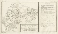
This detailed 18th-century copperplate engraving, titled Carte des Environs du Cap Français et des Paroisses qui en dépendent, depicts the surrounding area of Cap-Français (now Cap-Haïtien) on the north coast of the French colony of Saint-Domingue, present-day Haiti. The map extends along the coastline from Port Dauphin in the east to L’Acul in the west, and inland to the mountainous interior.
Key settlements, parishes (paroisses), and quarters are labeled, including Plaine du Nord, Quartier de la Grande Rivière, Quartier de la Soufrière, and Quartier des Terriers Rouges. Roads and rivers are clearly delineated, showing the connections between coastal towns and inland plantations. Mountain ranges are depicted pictorially, giving a sense of the rugged terrain that separated the fertile plains from the interior.
The map includes maritime features such as reefs, sandbanks, and ports, notably the harbour of Cap-Français itself, with the nearby Carénage and La Caye Vieille. Fortifications, such as Fort Dauphin, are also indicated. A large compass rose in the upper left provides orientation, and the scale is given in common French leagues.
Engraved by Porlier (Porlier Sculp.), this plate is marked “Tome 8, N° 2,” identifying it as part of a larger Enlightenment-era travel and colonial history series. During the mid-18th century, Cap-Français was the wealthiest city in the Caribbean and the center of the sugar trade in Saint-Domingue, making it a frequent subject of maps and engravings for European audiences interested in colonial commerce and expansion.
Condition: Very good for age, with a central fold as issued. Light toning and a few faint handling marks in margins. Strong plate impression with crisp detail in both topography and settlement layout.
Framing tips: A black or dark wood frame with a cream or light tan mount will complement the fine engraving work. This map pairs well with other 18th-century Caribbean or colonial maps for thematic display.
Technique: Copperplate engraving
Maker: A. Porlier, French school, c.1760
- Dimensions:Height: 7.88 in (20 cm)Width: 12.41 in (31.5 cm)Depth: 0.01 in (0.2 mm)
- Materials and Techniques:Paper,Engraved
- Place of Origin:
- Period:
- Date of Manufacture:circa 1760
- Condition:Condition: Very good for age, with central folds as issued. Light toning and a few faint handling marks in margins. Strong plate impression with crisp detail in both topography and settlement layout.
- Seller Location:Langweer, NL
- Reference Number:Seller: BG-14078-311stDibs: LU3054346218112
About the Seller
5.0
Recognized Seller
These prestigious sellers are industry leaders and represent the highest echelon for item quality and design.
Platinum Seller
Premium sellers with a 4.7+ rating and 24-hour response times
Established in 2009
1stDibs seller since 2017
2,569 sales on 1stDibs
Typical response time: <1 hour
- ShippingRetrieving quote...Shipping from: Langweer, Netherlands
- Return Policy
Authenticity Guarantee
In the unlikely event there’s an issue with an item’s authenticity, contact us within 1 year for a full refund. DetailsMoney-Back Guarantee
If your item is not as described, is damaged in transit, or does not arrive, contact us within 7 days for a full refund. Details24-Hour Cancellation
You have a 24-hour grace period in which to reconsider your purchase, with no questions asked.Vetted Professional Sellers
Our world-class sellers must adhere to strict standards for service and quality, maintaining the integrity of our listings.Price-Match Guarantee
If you find that a seller listed the same item for a lower price elsewhere, we’ll match it.Trusted Global Delivery
Our best-in-class carrier network provides specialized shipping options worldwide, including custom delivery.More From This Seller
View AllMartinique Map by Rigobert Bonne – French Antique Map, c.1768
Located in Langweer, NL
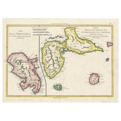
Map of Martinique by Rigobert Bonne, circa 1768
This is a detailed antique map of Martinique titled “Isle de la Martinique,” engraved by Rigobert Bonne around 1768 for the Atlas Encyclopédique. Bonne, a renowned French hydrographer and successor to Bellin, is celebrated for his scientifically precise and elegantly engraved maps.
The map shows Martinique with its mountainous interior, rivers, and settlements labelled, including Fort Royal, Fort St. Pierre, Le Marin, and Le Prêcheur. Coastal features, bays, and capes are marked, along with anchorages important for maritime navigation in the 18th century. The depiction includes relief shown pictorially, characteristic of Bonne’s cartographic style, enhancing both geographic understanding and aesthetic appeal.
This copperplate engraving retains original hand colouring outlining the coastlines in delicate blue and brown tones, typical for the period. It served as a key reference for scholars, navigators, and colonial administrators during France’s colonial presence in the Caribbean.
Condition:
Good condition overall. A strong impression with bright, original hand-colour outlines. General age toning, faint offsetting, and a vertical fold as issued in the atlas. Margins ample all around for framing.
Framing suggestions:
This historic Caribbean map...
Category
Antique 1760s French Maps
Materials
Paper

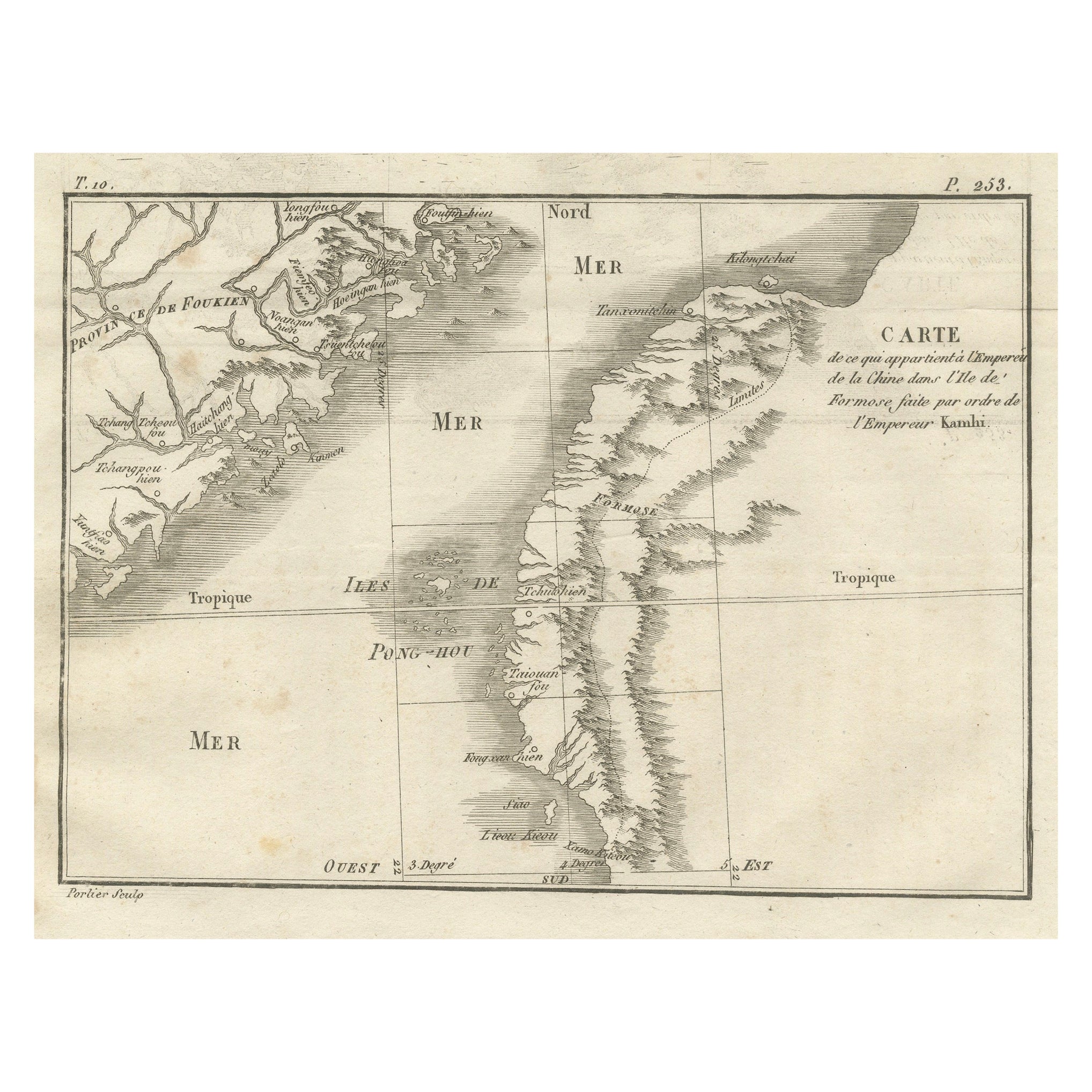
Map of Formosa and Pescadores – French Jesuit Engraving by Portier, c.1790
Located in Langweer, NL
Map of Formosa and Pescadores – French Jesuit Engraving by Portier, c.1790
This antique French map, engraved by Portier around 1790, depicts the island of Formosa (modern Taiwan), t...
Category
Antique Late 18th Century French Maps
Materials
Paper
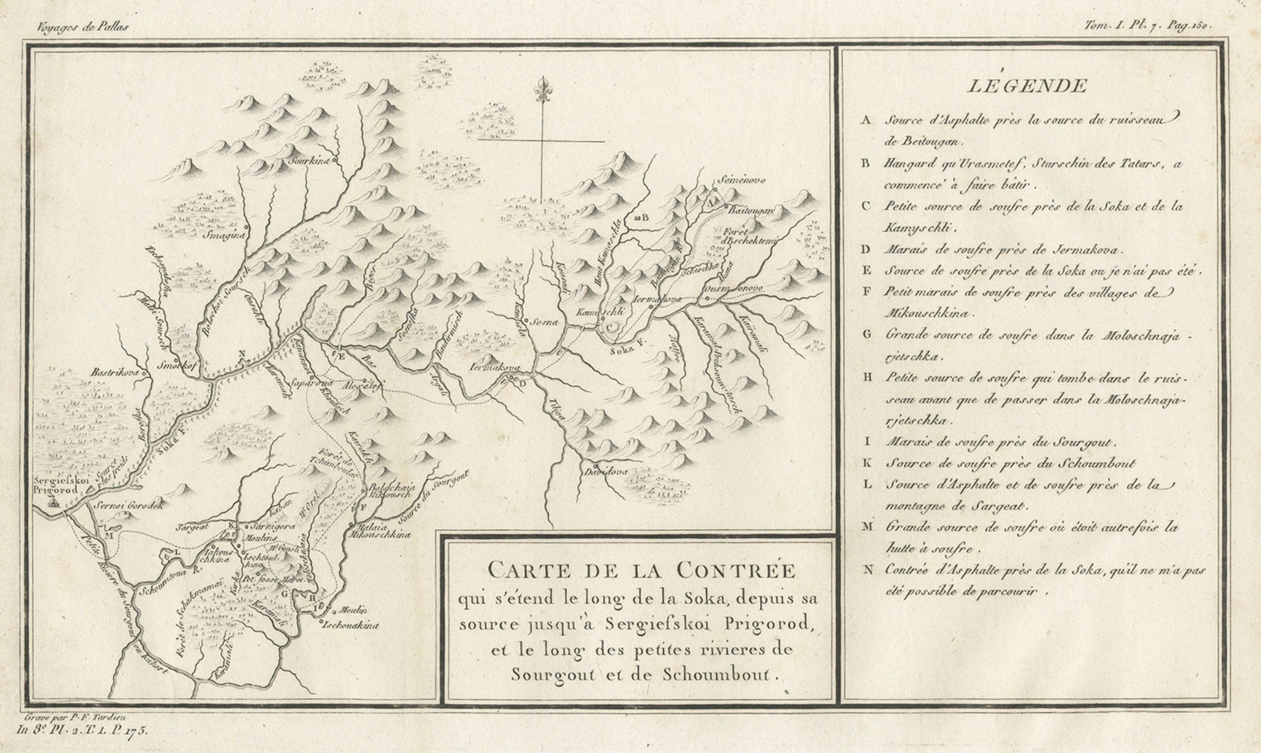
Antique Map of the Region of the Sok River in Russia, 1794
Located in Langweer, NL
Antique map titled 'Carte de la Contrée qui s’étend le long de la Soka, depuis sa source jusquá Sergiefskoi Prigorod et le long des petites rivieres de Sourgout et de Schoumbout’.
...
Category
Antique 18th Century Maps
Materials
Paper
Antique Map of the Lorraine Region, c.1760
Located in Langweer, NL
Untitled antique map of the Lorraine region, France. A cultural and historical region in north-eastern France, now located in the administrative region of Grand Est. Lorraine's name ...
Category
Antique 18th Century Maps
Materials
Paper

$209 Sale Price
20% Off
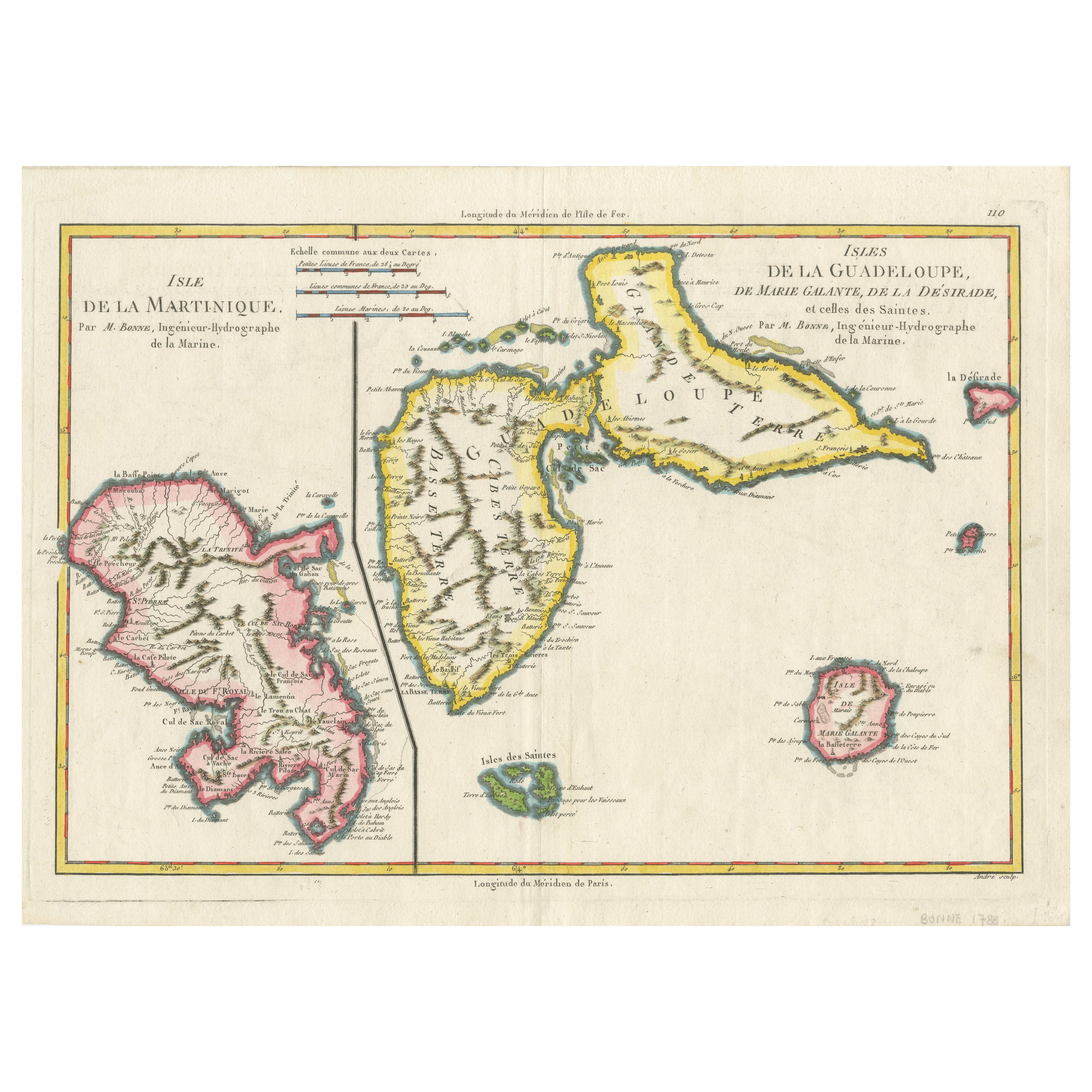
Map of Martinique, Guadeloupe, Marie-Galante, Désirade & Saintes by Bonne, 1788
Located in Langweer, NL
Map of Martinique, Guadeloupe, Marie-Galante, Désirade & Saintes by Bonne, 1788
This fine antique map, titled *Isle de la Martinique, Isles de la Guadeloupe, de Marie Galante, de la...
Category
Antique Late 18th Century French Maps
Materials
Paper
Antique Map of ancient France by Zannoni, 1765
Located in Langweer, NL
Antique map France titled 'Galliae Veteris (..)'. Beautiful old map of France. This map originates from 'Atlas Historique de la France Ancienne et Moderne' ...
Category
Antique 18th Century Maps
Materials
Paper

$305 Sale Price
20% Off
You May Also Like
Antique 1765 Wine Country Folding Map of France, Bordeau etc.
Located in Paonia, CO
Route du Carosse de Bordeaux, part de Paris tous les Mardis a 11 matin. a et pafse 1765 is a comprehensive map with two routes through the wine country of France starting in Paris going south...
Category
1760s Other Art Style Landscape Prints
Materials
Etching

Original Antique Map of Switzerland, Engraved By Barlow, Dated 1807
Located in St Annes, Lancashire
Great map of Switzerland
Copper-plate engraving by Barlow
Published by Brightly & Kinnersly, Bungay, Suffolk.
Dated 1807
Unframed.
Category
Antique Early 1800s English Maps
Materials
Paper

1771 Bonne Map of Poitou, Touraine and Anjou, France, Ric.a015
Located in Norton, MA
1771 Bonne Map of Poitou,
Touraine and Anjou, France
Ric.a015
1771 Bonne map of Potiou, Touraine and Anjou entitled "Carte des Gouvernements D'Anjou et du Saumurois, de la Touraine, du Poitou,du Pays d'aunis, Saintonge?Angoumois,"
Carte des gouvernements d'Anjou et du Saumurois, de la Touraine, du Poitou, du Pays d'Aunis, Saintonge-Angoumois. Projettee et assujettie au ciel par M. Bonne, Hyd. du Roi. A Paris, Chez Lattre, rue St. Jacques a la Ville de Bord(ea)ux. Avec priv. du Roi. 1771. Arrivet inv. & sculp., Atlas moderne ou collection de cartes sur toutes...
Category
Antique 17th Century Unknown Maps
Materials
Paper

Antique French Map of Asia Including China Indoneseia India, 1783
Located in Amsterdam, Noord Holland
Very nice map of Asia. 1783 Dedie au Roy.
Additional information:
Country of Manufacturing: Europe
Period: 18th century Qing (1661 - 1912)
Condition: Overall Condition B (Good Used)...
Category
Antique 18th Century European Maps
Materials
Paper

$648 Sale Price
20% Off
Original Antique Map of Ancient Greece, Achaia, Corinth, 1786
Located in St Annes, Lancashire
Great map of Ancient Greece. Showing the region of Thessaly, including Mount Olympus
Drawn by J.D. Barbie Du Bocage
Copper plate engraving by P.F Tardieu
Original hand color...
Category
Antique 1780s French Other Maps
Materials
Paper

1714 Henri Chatelain "Nouvelle Carte Des Etatas Du Grand.Duc De Mos Moscovie Eur
Located in Norton, MA
A 1714 Henri Chatelain map, entitled
"Nouvelle Carte Des Etatas Du Grand Duc De Moscovie En Europe,"
Ricb001
Henri Abraham Chatelain (1684-1743) was a Huguenot pastor of Parisi...
Category
Antique Early 18th Century Dutch Maps
Materials
Paper
