Items Similar to Antique Map of Granada Spain – Hand-Coloured Tassin Engraving 1651


Want more images or videos?
Request additional images or videos from the seller
1 of 10
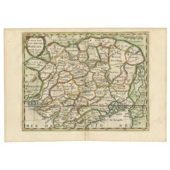
Antique Map of Granada Spain – Hand-Coloured Tassin Engraving 1651
$518.59
£390.60
€440
CA$715.16
A$803.45
CHF 419.81
MX$9,806.53
NOK 5,330.31
SEK 5,017.36
DKK� 3,349.11
About the Item
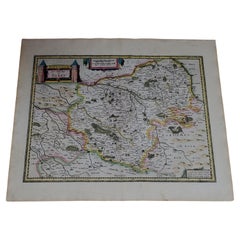
Antique Map of Granada Spain – Hand-Coloured Tassin Engraving 1651
This beautiful hand-coloured engraved map depicts the historic Kingdom of Granada in southern Spain, created by the renowned French cartographer Nicolas Tassin and published in 1651 by Nicolas Berey in ‘Cartes Generales des Provinces de France et d’Espagne’. Titled ‘Reyno de Granada’, the map shows the region with remarkable detail, highlighting the major towns, mountain ranges, and coastal features of this historically significant kingdom.
The map features Granada, Cordova, Malaga, Almeria, and many other settlements, set against a backdrop of stylised mountain ranges such as the Sierra Nevada, engraved in a manner typical of early baroque cartography. Three elegant sailing ships are depicted in the Mediterranean Sea, adding to its decorative charm. The lower part of the map includes an ornate title cartouche and a simple coat of arms motif, enhancing its visual appeal.
Nicolas Tassin was a prominent cartographer in mid-17th-century France, known for his precise provincial and regional maps. This map was engraved using the copperplate technique on hand-laid paper and finished with contemporary hand colouring, which remains vivid and enhances the engraving’s clarity and aesthetic. Maps by Tassin are valued by collectors for their combination of geographical precision, compact size, and attractive decorative elements.
Condition summary: The map is in very good condition with strong engraving impressions and vibrant original colours. There is slight age-related toning and some faint spotting in the margins, consistent with a map of this age, but the image area remains clean and fresh. The edges have minor browning, and the corners show light handling wear without tears or repairs.
Framing tips: For optimal presentation, frame with a dark wood or gilt moulding to echo the baroque feel. Use a neutral cream or lightly textured off-white mount board to highlight the vivid colours and intricate engraving. Conservation-grade UV-protective glass is recommended to preserve the pigments and paper integrity for decades to come.
This is a rare opportunity to acquire an original 17th-century map of Granada by Nicolas Tassin, ideal for collectors, historians, or as an elegant decorative piece for classic European-themed interiors, libraries, or studies.
- Dimensions:Height: 5.91 in (15 cm)Width: 7.72 in (19.6 cm)Depth: 0.01 in (0.2 mm)
- Materials and Techniques:Paper,Engraved
- Place of Origin:
- Period:Mid-17th Century
- Date of Manufacture:1651
- Condition:Condition summary: The map is in very good condition with strong engraving impressions and vibrant original colours. There is slight age-related toning and some faint spotting in the margins, consistent with a map of this age. The image is clean.
- Seller Location:Langweer, NL
- Reference Number:Seller: Bg-14106-21stDibs: LU3054345767632
About the Seller
5.0
Recognized Seller
These prestigious sellers are industry leaders and represent the highest echelon for item quality and design.
Platinum Seller
Premium sellers with a 4.7+ rating and 24-hour response times
Established in 2009
1stDibs seller since 2017
2,533 sales on 1stDibs
Typical response time: <1 hour
- ShippingRetrieving quote...Shipping from: Langweer, Netherlands
- Return Policy
Authenticity Guarantee
In the unlikely event there’s an issue with an item’s authenticity, contact us within 1 year for a full refund. DetailsMoney-Back Guarantee
If your item is not as described, is damaged in transit, or does not arrive, contact us within 7 days for a full refund. Details24-Hour Cancellation
You have a 24-hour grace period in which to reconsider your purchase, with no questions asked.Vetted Professional Sellers
Our world-class sellers must adhere to strict standards for service and quality, maintaining the integrity of our listings.Price-Match Guarantee
If you find that a seller listed the same item for a lower price elsewhere, we’ll match it.Trusted Global Delivery
Our best-in-class carrier network provides specialized shipping options worldwide, including custom delivery.More From This Seller
View AllAntique Map of Andalusia Spain – Hand-Coloured Tassin Engraving 1651
Located in Langweer, NL
Antique Map of Andalusia Spain – Hand-Coloured Tassin Engraving 1651
This fine hand-coloured engraved map shows the historic kingdom of Andalusia in southern Spain, created by Nicol...
Category
Antique Mid-17th Century French Maps
Materials
Paper

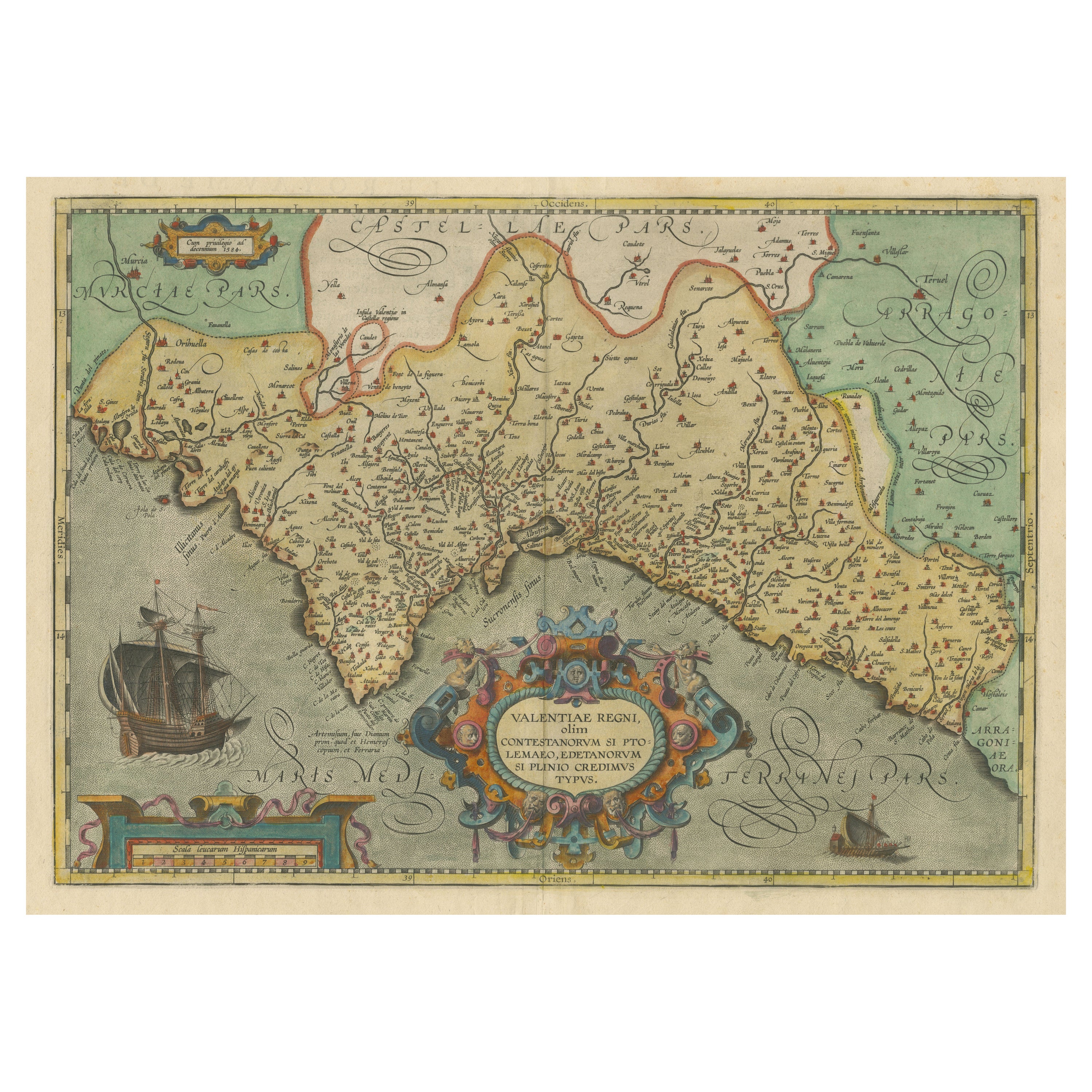
Decorative Original Antique Map of Valencia in Southern Spain, circa 1601
Located in Langweer, NL
This is an original antique map titled 'Valentiae Regni olim Contestanorum Si Ptolemaeo, Edentanorum Si Plinio Credimus Typus'. This is a historical map of the Kingdom of Valencia in...
Category
Antique Early 17th Century Maps
Materials
Paper

$1,320 Sale Price
20% Off
Free Shipping
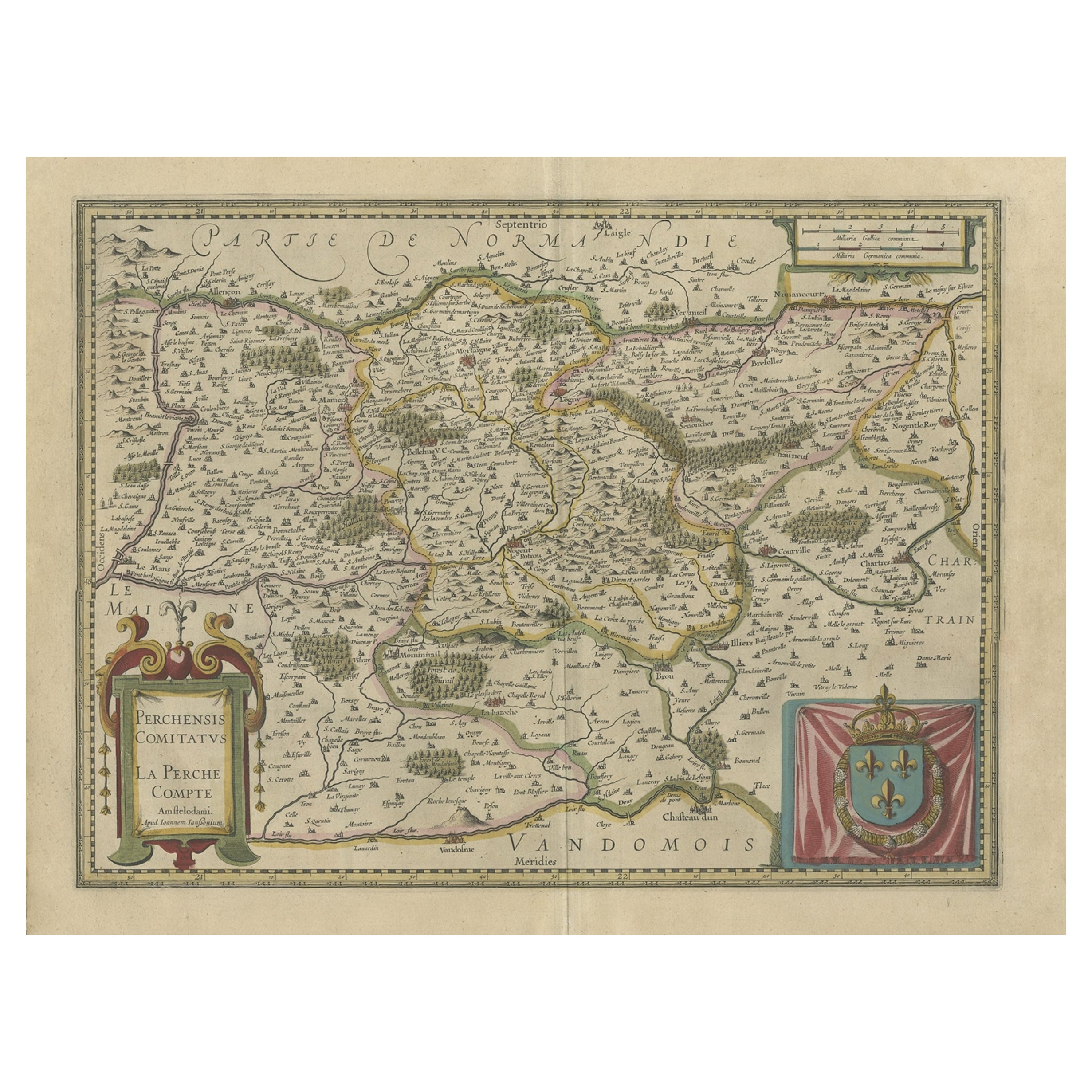
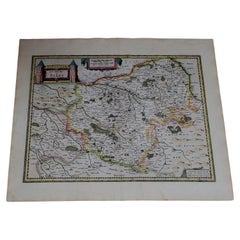
Old Original Handcoloured Map of the Former Province of Perche, France, ca.1640
Located in Langweer, NL
Antique map titled 'Perchensis Comitatus - La Perche compte'.
Old map of the former province of Perche, France. Until the French Revolution, Perche was bounded by four ancient te...
Category
Antique 1640s Maps
Materials
Paper
$678 Sale Price
20% Off
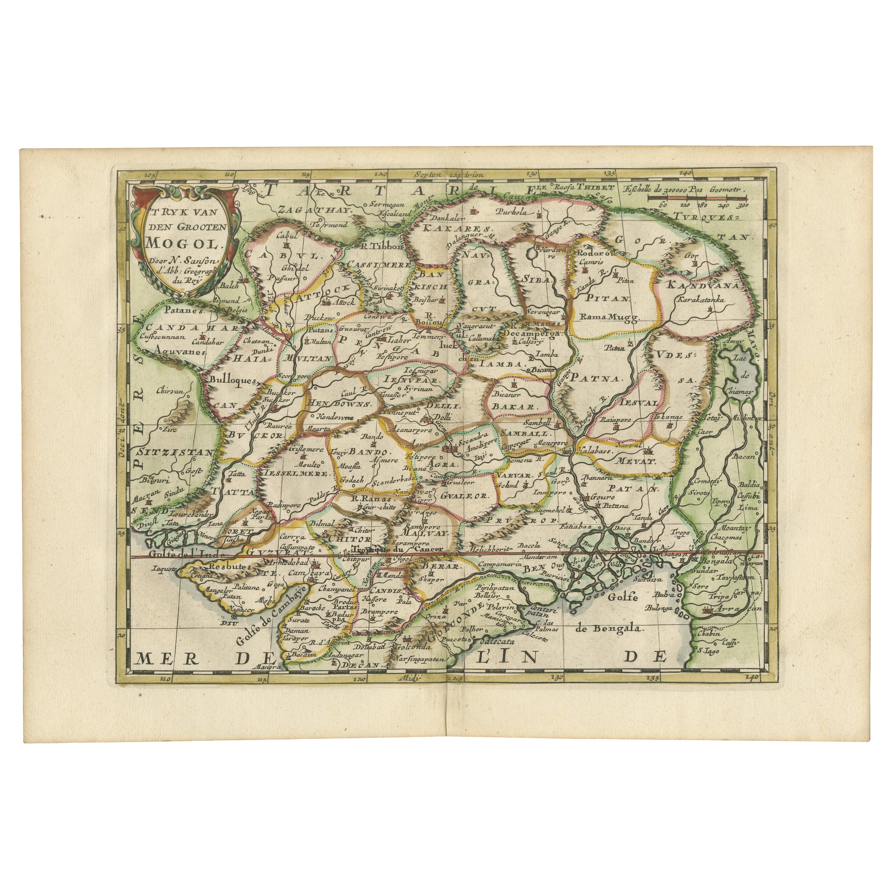
Cartographic Elegance of the Mughal Dominion in a Hand-Colored Antique Map, 1705
Located in Langweer, NL
This original antique map titled “'T Ryk van den Grooten Mogol” by Nicolas Sanson from 1705 is an interesting historical artifact. It depicts the extent of the Mughal Empire in North...
Category
Antique Early 1700s Maps
Materials
Paper
$622 Sale Price
20% Off
Free Shipping
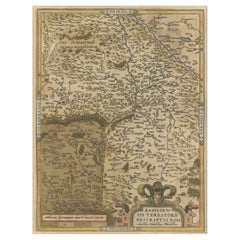
Very Old Original Hand-Colored Map of the Basel Region, Switzerland, Ca.1578
Located in Langweer, NL
Antique print titled 'Basiliensis territorii descriptio nova'.
Old map of the Basel region, Switzerland. Originates from 'Theatrum Orbis Terrarum' by A. Ortelius.
Artists and...
Category
Antique 16th Century Maps
Materials
Paper
$688 Sale Price
20% Off
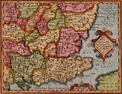
Antique Map of the Picardy Region of France by Ortelius, 'circa 1590'
Located in Langweer, NL
Antique map titled 'Picardiae Belgicae regionis descriptio'. Original antique map of the Picardy region, France. Published by A. Ortelius, circa 1590.
Category
Antique 16th Century Maps
Materials
Paper

$565 Sale Price
20% Off
You May Also Like
1571-1638 Willem Blaeu map entitled, "Ilcadorino, " Hand Colored Ric0009
Located in Norton, MA
Willem Blaeu map entitled,
"Ilcadorino,".
Hand colored.
Description: large, unusual, and nice antique copper engraved map of Ilcadorino, by Willem BL...
Category
Antique 16th Century Dutch Maps
Materials
Paper

Southeastern England: A 17th Century Hand-Colored Map by Mercator and Hondius
By Gerard Mercator
Located in Alamo, CA
A 17th century copperplate hand-colored map entitled "The Sixt Table of England" by Gerard Mercator and Jodocus Hondius, published in Amsterdam in 1635 in 'Cosmographicall Descriptio...
Category
1630s Landscape Prints
Materials
Engraving
1633 map, entitled "La douche de Berry, " Original Hand Colored Ric.0005
Located in Norton, MA
1633 map, entitled
"La douche de Berry,"
Hand Colored
Ric.0005
Description:
1633 map, entitled "La douche de Berry,"
Dimension: Paper: 23.3" W x 20.3" H (59 cm W x 51.7 cm H) ; ...
Category
Antique 17th Century Dutch Maps
Materials
Paper
1633 Map, Entitled "La Douche De Berry, " Original Hand Colored Ric.0005
Located in Norton, MA
1633 map, entitled.
"La douche de Berry,"
Hand Colored
Ric.0005
Description:
1633 map, entitled "La douche de Berry,".
Dimension: Paper: 23.3" W x 20.3" H (59 cm W x 51.7...
Category
Antique 17th Century Unknown Maps
Materials
Paper
1633 Map Entitled "Beauvaisis Comitatus Belova Cium, Ric.0002
Located in Norton, MA
1633 map entitled
"Beauvaisis Comitatus Belova Cium,"
Hand Colored
Ric.0002
Description: Cartographer : - Hondius, Henricus 1587-1638
Artists and Engravers:Jodocus Hondius, one of the most notable engravers of his time. He is known for his work in association with many of the cartographers and publishers prominent at the end of the sixteenth and the beginning of the seventeenth century. A native of Flanders, he grew up in Ghent, apprenticed as an instrument and globe maker and map engraver. In 1584, to escape the religious troubles sweeping the Low Countries at that time, he fled to London where he spent some years before finally settling in Amsterdam about 1593. In the London period he came into contact with the leading scientists and geographers of the day and engraved maps in The Mariner\\\\\\\\\\\\\\\'s Mirrour, the English edition of Waghenaer\\\\\\\\\\\\\\\'s Sea Atlas, as well as others with Pieter van den Keere, his brother-in-law. No doubt his temporary exile in London stood him in good stead, earning him an international reputation, for it could have been no accident that Speed chose Hondius to engrave the plates for the maps in The Theatre of the Empire of Great Britaine in the years between 1605 and 1610. In 1604 Hondius bought the plates of Mercator\\\\\\\\\\\\\\\'s Atlas which, in spite of its excellence, had not competed successfully with the continuing demand for the Ortelius Theatrum Orbis Terrarum. To meet this competition Hondius added about 40 maps to Mercator\\\\\\\\\\\\\\\'s original number and from 1606 published enlarged editions in many languages, still under Mercator\\\\\\\\\\\\\\\'s name but with his own name as publisher. These atlases have become known as the Mercator/Hondius series. The following year the maps were reengraved in miniature form and issued as a pocket Atlas Minor. After the death of Jodocus Hondius the Elder in 1612, work on the two atlases, folio and miniature, was carried on by his widow and sons, Jodocus II and Henricus, and eventually in conjunction with Jan Jansson in Amsterdam.
In all, from 1606 onwards, nearly 50 editions with increasing numbers of maps with texts in the main European languages were printed. Summaries of these issues are given under the entry for Gerard Mercator. Jodocus Hondius the Elder * 1588 Maps in The Mariner\\\\\\\\\\\\\\\'s Mirrour (Waghenaer/Ashley) * 1590 World Map...
Category
Antique 17th Century Dutch Maps
Materials
Paper

West Germany: Original Hand Colored 17th Century Map by Johannes Janssonius
By Johannes Janssonius
Located in Alamo, CA
An original hand colored copperplate engraved map entitled in Latin "Archiepiscopatus Maghdeburgensis et Anhaltinus Ducatus cum terris adjacentibus", published in Amsterdam in 1640 i...
Category
Mid-17th Century Old Masters More Prints
Materials
Engraving

More Ways To Browse
Spanish Library
Antique Backdrop
Classic Engraving
Set Of Framed Engravings
Coat Of Arms Engraving
Spanish Provincial
Antique Hand Carts
Antique Hand Trolley
Gilt Coat Of Arms
Spanish Frame 17th Century
Wood Minimalist Chair
Antique Imperial Furniture
Gold Modern Coffee Table
Large Side Tables
18th Century Gilded Furniture
Japanese Silver Ceramics
One Of A Kind Chair
Used Oak Dining Room Chairs