Items Similar to Cartographic Elegance of the Mughal Dominion in a Hand-Colored Antique Map, 1705

Want more images or videos?
Request additional images or videos from the seller
1 of 8
Cartographic Elegance of the Mughal Dominion in a Hand-Colored Antique Map, 1705
About the Item
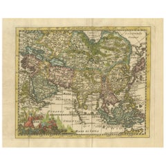
This original antique map titled “'T Ryk van den Grooten Mogol” by Nicolas Sanson from 1705 is an interesting historical artifact. It depicts the extent of the Mughal Empire in Northern India and adjacent regions during the early 18th century. This period corresponds to the later years of the Mughal Empire's peak and hints towards its subsequent decline.
The map shows the political divisions, topography, cities, and major towns of the time. The presence of the mythical Lac de Chiamay, a lake that was once thought to be the source of important Southeast Asian rivers, is particularly notable for illustrating the geographical misconceptions of that era.
Sanson's maps were widely copied and reissued with various modifications by different publishers, indicating their popularity and the importance of his work in the cartographic community. These maps would have been used for navigation, trade, and also to assert political claims over territories.
In more detail:
Title: “'T Ryk van den Grooten Mogol”
Subject: Northern India
Creator: Sanson, Nicolas
Date: 1705 (published)
Color: Hand Color
Size: 9.7 x 7.6 inches (24.6 x 19.3 cm)
Source: Algemeene Weereld-Beschryving…
Description: This small map covers Northern India and present-day Nepal and Bangladesh and shows the political divisions, topography, cities and major towns. At right is the mythical Lac de Chiamay with three rivers flowing south. It is decorated with a strapwork title cartouche.
Sanson's small maps from his L'Asie en Plusieurs Cartes..., first published in 1652 and engraved by A. Peyrounin, were copied several times by various map publishers. Johann David Zunners made copies of Sanson's maps for his German translation of Die Gantze Erd-Kugel in 1679. Johannes Ribbius and Simon de Vries published copies in 1682 and 1683, with new maps engraved by Antoine d'Winter. The plates were later sold to Francois Halma, who used them in 1699 and then again in 1705 with the titles re-engraved in Dutch. The titles on the d'Winter plates were re-engraved back into French, and then used by Nicholas Chemereau in 1715 and by Henri du Sauzet in 1738.
- Dimensions:Height: 8.67 in (22 cm)Width: 11.89 in (30.2 cm)Depth: 0 in (0.02 mm)
- Materials and Techniques:Paper,Engraved
- Period:1700-1709
- Date of Manufacture:1705
- Condition:Very good. A dark and attractive impression on a bright sheet and a narrow top margin. Middle fold as issued. Study the scans carefully.`.
- Seller Location:Langweer, NL
- Reference Number:
About the Seller
5.0
Platinum Seller
These expertly vetted sellers are 1stDibs' most experienced sellers and are rated highest by our customers.
Established in 2009
1stDibs seller since 2017
1,922 sales on 1stDibs
Typical response time: <1 hour
- ShippingRetrieving quote...Ships From: Langweer, Netherlands
- Return PolicyA return for this item may be initiated within 14 days of delivery.
More From This SellerView All
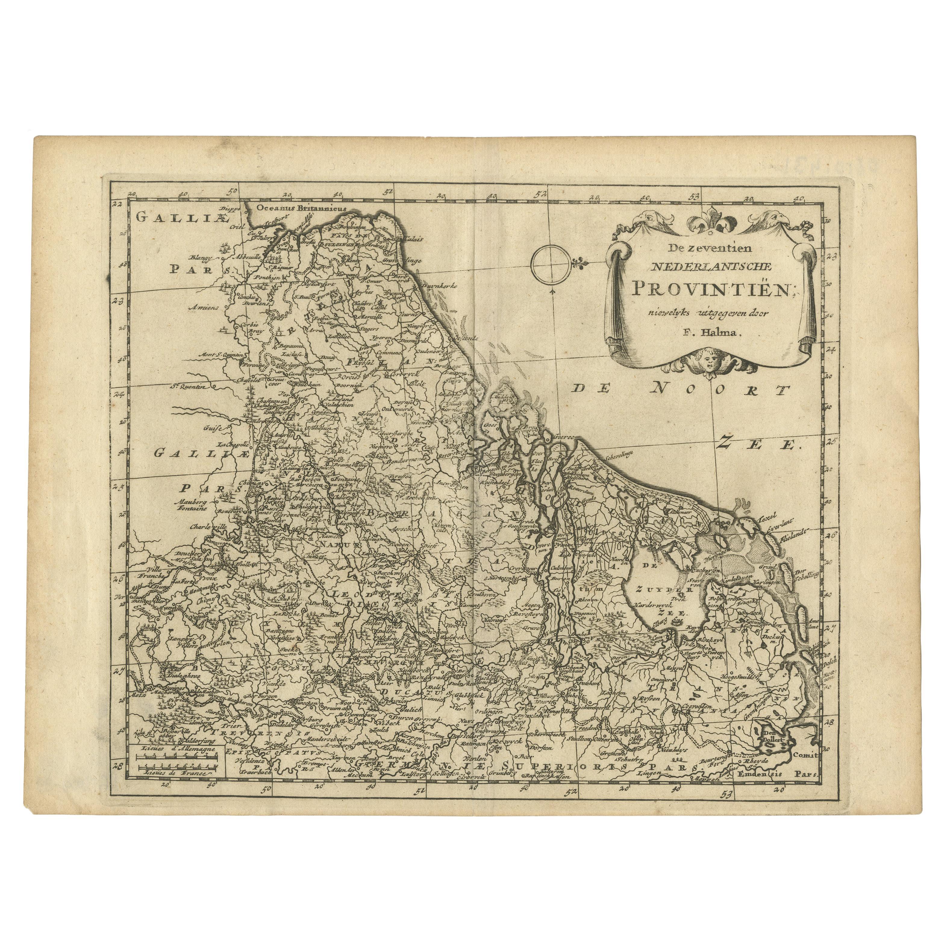
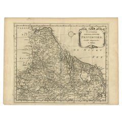
- Antique Map of the Seventeen Provinces by Halma '1705'Located in Langweer, NLAntique map titled 'De zeventien Nederlantsche Provintiën'. Original antique map of the Seventeen Provinces, the Imperial states of the Habsburg Netherlands in the 16th century. This...Category
Antique Early 18th Century Maps
MaterialsPaper
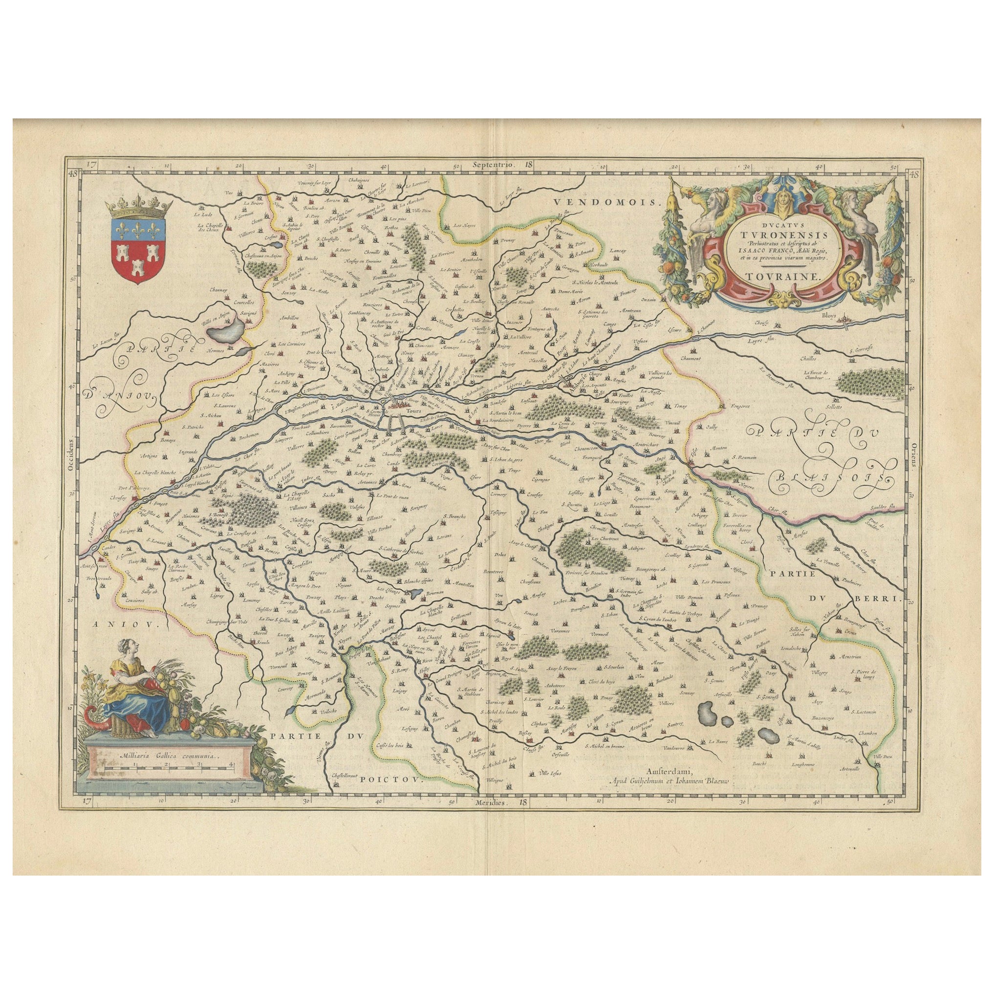
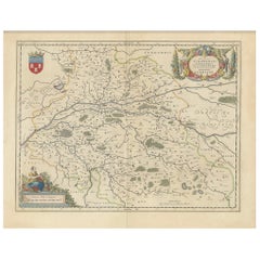
- Cartographic Elegance of Touraine: A 17th-Century Map Showing French HeritageLocated in Langweer, NL"Ducatus Turonensis - Touraine," is a original antique historical map of the Touraine region, which is located in the heart of France, centered...Category
Antique 1630s Maps
MaterialsPaper
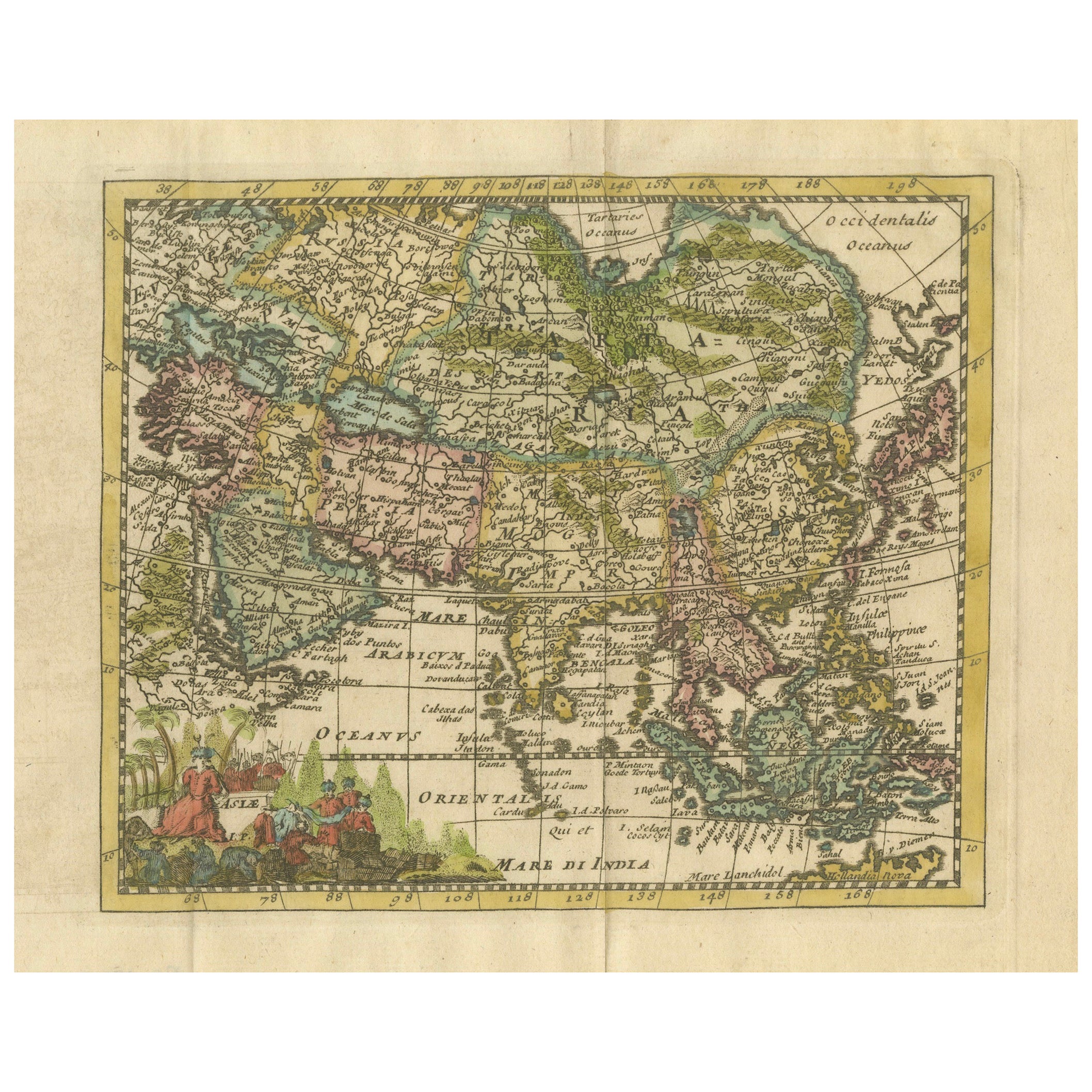
- Antique Map of Russia by N. Sanson, 1705Located in Langweer, NLA strongly engraved map of European Russia showing its political divisions, major topographical features, cities and towns. Extends to the Sea of Azov and the tip of the Caspian Sea ...Category
Antique Early 18th Century Maps
MaterialsPaper
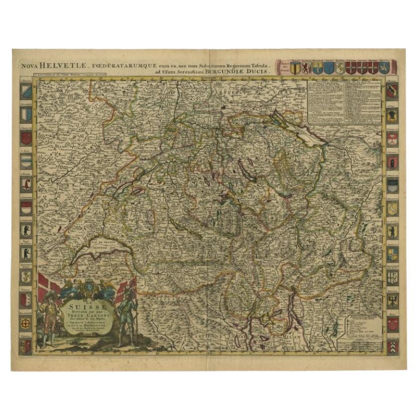
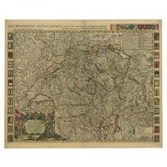
- Antique Map of Switzerland by Jaillot, c.1705Located in Langweer, NLAntique map Switerzland titled 'La Suisse Divisee en ses Treze Cantons, ses Alliez & ses Sujets (..)'. Beautiful map of Switzerland with 33 coats of arms. The map is dedicated to the...Category
Antique 18th Century Maps
MaterialsPaper
- Cartographic Elegance: The Art and Science of 17th-Century Asian Maps, ca.1681Located in Langweer, NLThis original antique map is an artifact from a pivotal era in cartography, reflecting not only the geographical knowledge of its time but also the intertwining of art and science in...Category
Antique 1680s Maps
MaterialsPaper
- Hand Colored Antique Map of the department of Loiret, FranceBy Victor LevasseurLocated in Langweer, NLAntique map titled 'Dépt. du Loiret'. Map of the French department of Loiret, France. Surrounding the city of Orleans, Loiret is considered the heart of France and is a registered Unesco World Heritage Site. This area of France is also part of the Loire Valley wine region, and is especially known for its production of Pinot Noirs...Category
Antique Mid-19th Century Maps
MaterialsPaper

You May Also Like
- Antique Hand Colored Framed Map of EuropeLocated in West Palm Beach, FLAntique reproduction copied from an edition dated 1595 by Ortelius.Category
Antique Late 19th Century Maps
- Antique Oarsman's Map of the River Thames, English, Cartography, Published 1912Located in Hele, Devon, GBThis is an antique copy of The Oarsman's and Angler's Map of the River Thames - New Edition. An English, bound map book, published in English by Edward Stanford, London, this new edi...Category
Early 20th Century British Other Books
MaterialsPaper
- Antique Lithography Map of Cheshire, English, Framed, Cartography, VictorianLocated in Hele, Devon, GBThis is an antique lithography map of Cheshire. An English, framed atlas engraving of cartographic interest, dating to the mid 19th century and lat...Category
Antique Mid-19th Century British Victorian Maps
MaterialsWood
- Framed 1820s Hand Colored Map of the United StatesLocated in Stamford, CTFramed 1820s hand colored map photos of North America and South America. As found framed in giltwood frame.Category
Antique 1820s American Spanish Colonial Maps
MaterialsGiltwood, Paper, Glass
- Framed 1839 Hand Colored Map of the United StatesLocated in Stamford, CTFramed hand colored map of the United States of America from 1839. Newly framed in a giltwood frame.Category
Antique 1830s American American Classical Maps
MaterialsGiltwood, Paper, Glass
- Antique Lithography Map, Isle of Wight, English, Framed, Engraving, CartographyLocated in Hele, Devon, GBThis is an antique lithography map of the Isle of Wight. An English, framed atlas engraving of cartographic interest, dating to the early 19th century and later. Superb lithography ...Category
Antique Early 19th Century British Regency Maps
MaterialsWood


