Items Similar to Antique Map of the Hesse Region of Germany by Blaeu, 1665

Want more images or videos?
Request additional images or videos from the seller
1 of 5
Antique Map of the Hesse Region of Germany by Blaeu, 1665
$347.76
£258.70
€290
CA$476.20
A$529.48
CHF 276.46
MX$6,445
NOK 3,527.54
SEK 3,305.14
DKK 2,207.61
Shipping
Retrieving quote...The 1stDibs Promise:
Authenticity Guarantee,
Money-Back Guarantee,
24-Hour Cancellation
About the Item
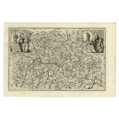
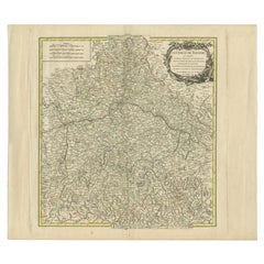
Antique map titled 'Hassia Landgraviatus'. Map of the Hesse Region of Germany. This map originates from 'Atlas Maior Sive Cosmographia Blaviana, Qua Solvm, Salvm, Coelvm, Accvratissime Describvntvr' by J. Blaeu.
Artists and Engravers: Joan Blaeu (23 September 1596 - 28 May 1673) was a Dutch cartographer. He was born in Alkmaar, the son of cartographer Willem Blaeu. In 1620 he became a doctor of law but he joined the work of his father. In 1635 they published the Atlas Novus (full title: Theatrum orbis terrarum, sive, Atlas novus) in two volumes. Joan and his brother Cornelius took over the studio after their father died in 1638. Joan became the official cartographer of the Dutch East India Company. Around 1649 Joan Blaeu published a collection of Dutch city maps named Tooneel der Steeden (Views of Cities). In 1651 he was voted into the Amsterdam council. In 1654 Joan published the first atlas of Scotland, devised by Timothy Pont. In 1662 he reissued the atlas with 11 volumes, and one for oceans. It was also known as Atlas Maior. A cosmology was planned as their next project, but a fire destroyed the studio completely in 1672. Joan Blaeu died in Amsterdam the following year.
Condition: Fair, original/contemporary hand coloring. General age-related toning, some soiling. Minor wear and small defects. German text on verso, please study image carefully.
Date: 1665
Overall size: 56.5 x 48 cm.
Image size: 55 x 45 cm.
We sell original antique maps to collectors, historians, educators and interior decorators all over the world. Our collection includes a wide range of authentic antique maps from the 16th to the 20th centuries. Buying and collecting antique maps is a tradition that goes back hundreds of years. Antique maps have proved a richly rewarding investment over the past decade, thanks to a growing appreciation of their unique historical appeal. Today the decorative qualities of antique maps are widely recognized by interior designers who appreciate their beauty and design flexibility. Depending on the individual map, presentation, and context, a rare or antique map can be modern, traditional, abstract, figurative, serious or whimsical. We offer a wide range of authentic antique maps for any budget
- Dimensions:Height: 18.9 in (48 cm)Width: 22.25 in (56.5 cm)Depth: 0 in (0.01 mm)
- Materials and Techniques:
- Period:
- Date of Manufacture:1665
- Condition:Condition: Fair, original/contemporary hand coloring. General age-related toning, some soiling. Minor wear and small defects. German text on verso, please study image carefully.
- Seller Location:Langweer, NL
- Reference Number:Seller: BG-12640-21stDibs: LU3054327796642
About the Seller
5.0
Recognized Seller
These prestigious sellers are industry leaders and represent the highest echelon for item quality and design.
Platinum Seller
Premium sellers with a 4.7+ rating and 24-hour response times
Established in 2009
1stDibs seller since 2017
2,510 sales on 1stDibs
Typical response time: <1 hour
- ShippingRetrieving quote...Shipping from: Langweer, Netherlands
- Return Policy
Authenticity Guarantee
In the unlikely event there’s an issue with an item’s authenticity, contact us within 1 year for a full refund. DetailsMoney-Back Guarantee
If your item is not as described, is damaged in transit, or does not arrive, contact us within 7 days for a full refund. Details24-Hour Cancellation
You have a 24-hour grace period in which to reconsider your purchase, with no questions asked.Vetted Professional Sellers
Our world-class sellers must adhere to strict standards for service and quality, maintaining the integrity of our listings.Price-Match Guarantee
If you find that a seller listed the same item for a lower price elsewhere, we’ll match it.Trusted Global Delivery
Our best-in-class carrier network provides specialized shipping options worldwide, including custom delivery.More From This Seller
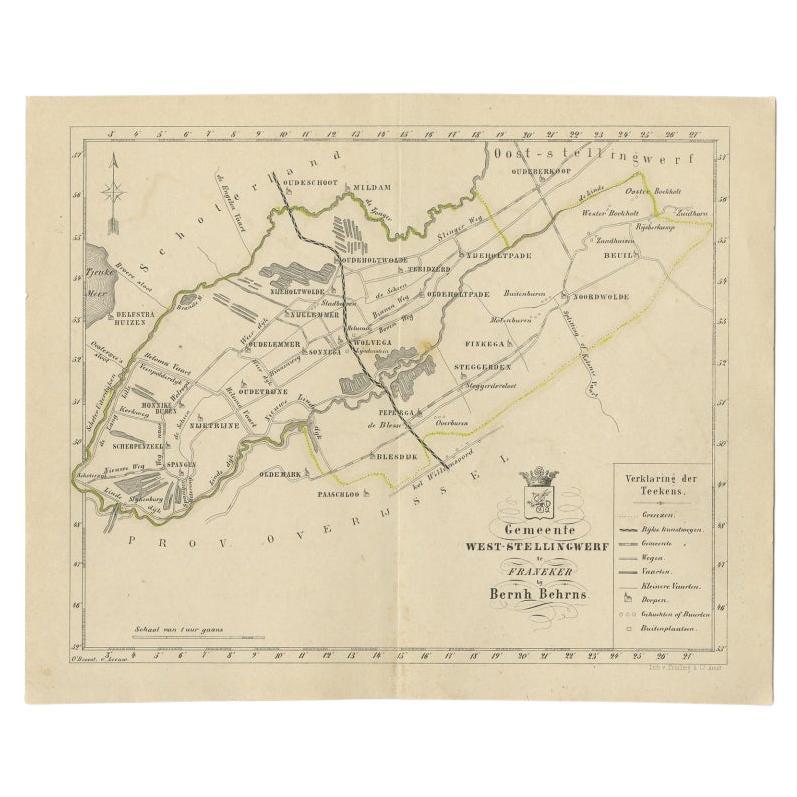
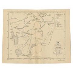
View AllAntique Map of The Dutch West-Stellingwerf Township by Behrns, 1861
Located in Langweer, NL
Antique map titled 'Gemeente West-Stellingwerf'. Old map depicting the West-Stellingwerf township including cities and villages like Noordwolde, Oldeholtwolde and Wolvega. This map o...
Category
Antique 19th Century Maps
Materials
Paper
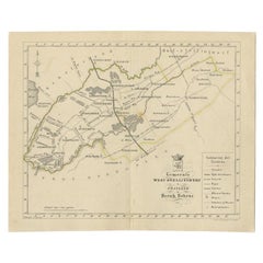
$115 Sale Price
20% Off
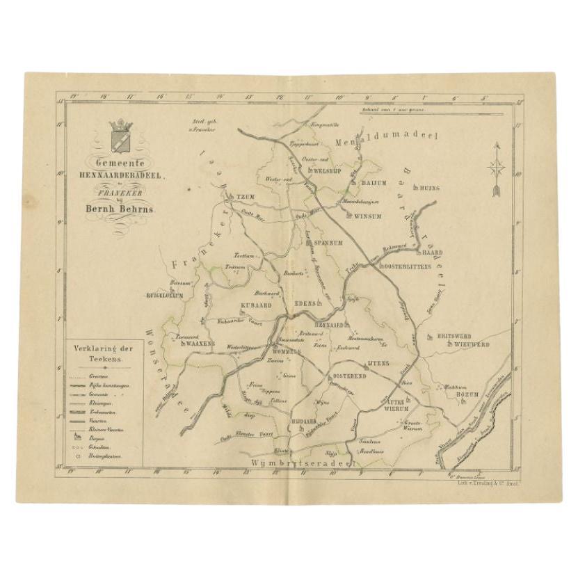
Antique Map of the Hennaarderadeel Township by Behrns, 1861
Located in Langweer, NL
Antique map titled 'Gemeente Hennaarderadeel'. Old map depicting the Hennaarderadeel township including cities and villages like Kubaard, Wommels, Hennaard, Oosterend, Wierum, Tzum, ...
Category
Antique 19th Century Maps
Materials
Paper
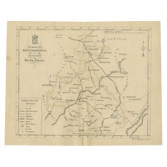
$85 Sale Price
20% Off
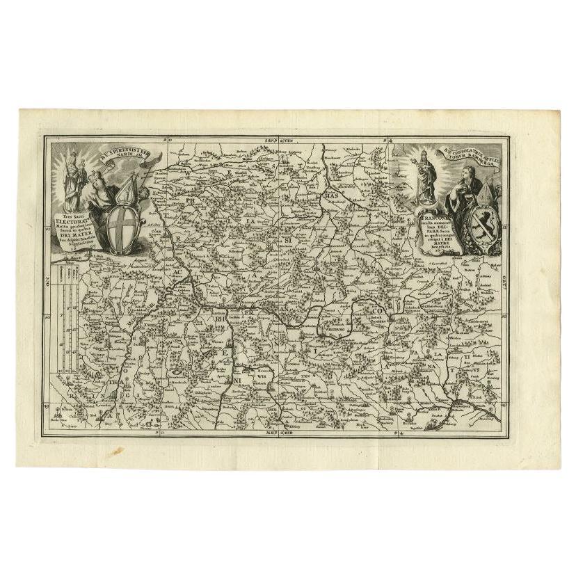
Antique Map of the Franconia Region by Scherer, 1699
Located in Langweer, NL
Antique map titled 'Franconia multa numerat loca deiparae sacra in quibus magna recipit à dei matre beneficia.' Detailed uncommon map of the Franconia region in Germany. Source unkno...
Category
Antique 17th Century Maps
Materials
Paper
$215 Sale Price
20% Off
Antique Map of The Dutch Township Rauwerderhem, 1861
Located in Langweer, NL
Antique map titled 'Gemeente Rauwerderhem'. Old map depicting the Rauwerderhem township including cities and villages like Deersum, Poppingawier, Rauwerd and Irnsum. This map orginat...
Category
Antique 19th Century Maps
Materials
Paper

$115 Sale Price
20% Off
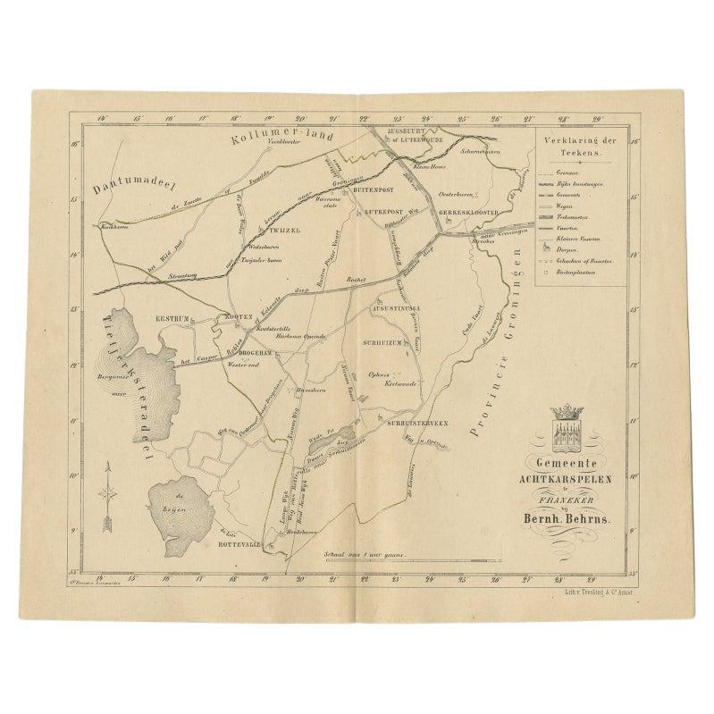
Antique Map of The Dutch Achtkarspelen Township by Behrns, 1861
Located in Langweer, NL
Antique map titled 'Gemeente Achtkarspelen'. Old map depicting the Achtkarspelen township including cities and villages like Buitenpost, Twijzel, Drogeham and Surhuisterveen. This ma...
Category
Antique 19th Century Maps
Materials
Paper
$115 Sale Price
20% Off
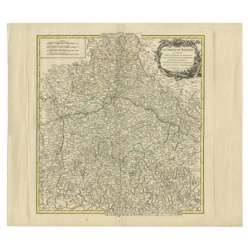
Antique Map of the Circle of Bavaria by Vaugondy, 1757
Located in Langweer, NL
Antique map titled 'Le Cercle de Baviere (..)'. Map of the Circle of Bavaria, Germany. Extends from Bamberg to Innsbruck. This map originates from 'Atlas Universel (..)'. Artists and Engravers: Gilles Robert de Vaugondy (1688 - 1766), also known as Le Sieur or Monsieur Robert, and his son, Didier Robert de Vaugondy (c.1723 - 1786), were leading mapmakers in France during the 18th century. In 1757, they published The Atlas Universel, one of the most important atlases of the 18th century. To produce the atlas, the Vaugondys integrated older sources with more modern surveyed maps...
Category
Antique 18th Century Maps
Materials
Paper
$190 Sale Price
20% Off
You May Also Like
1635 Willem Blaeu Map of Northern France"Comitatvs Bellovacvm" Ric.a08
Located in Norton, MA
1635 Willem Blaeu map of northern France, entitled.
"Comitatvs Bellovacvm Vernacule Beavvais,"
Colored
Ric.a008
“COMITATVS BELLOVACVM…” Amsterdam: W...
Category
Antique 17th Century Unknown Maps
Materials
Paper

1640 Joan Bleau Map Entitled"Diocecese de rheims et le pais de rethel, " Eic.a011
Located in Norton, MA
1640 Joan Bleau map entitled
"Diocecese de rheims et le pais de rethel,"
Ric.a011
OAN BLAEU
Diocecese de Rheims, et le pais de Rethel.
Handcolored engraving, c.1640.
...
Category
Antique 17th Century Dutch Maps
Materials
Paper

1657 Janssonius Map of Vermandois and Cappelle, Ric. A-004
Located in Norton, MA
1657 Janssonius map of
Vermandois and Cappelle
Ric.a004
Description: Antique map of France titled 'Descriptio Veromanduorum - Gouvernement de la Cappelle'. Two detailed maps o...
Category
Antique 17th Century Unknown Maps
Materials
Paper

1640 Willem Blaeu Map Entitled "Contado di molise et principato vltra, " Ric.a003
By Willem Blaeu
Located in Norton, MA
1640 Willem Blaeu map entitled
"Contado di molise et principato vltra,"
Colored
Ric. a003
Measures: 38 x 49.6 cm and wide margins
DBLAEU.
Cou...
Category
Antique 17th Century Dutch Maps
Materials
Paper

1620 Map of Artois Entitled "Artesia Comitatvs Artois, " by Bleau, Ric.a012
Located in Norton, MA
1640 map of Artois entitled
"Artesia Comitatvs Artois,"
by Bleau
Colored
A-012.
Detailed map of the northern province of Artois, France on the border with Belgium. Feature...
Category
Antique 17th Century Dutch Maps
Materials
Paper

Antique Map Of Brabantia Ducantus By Bleau Circa 1640
Located in Brussels, Brussels
map of theBrabantia Ducantus (Belgium) circa 1640 by Bléau. Bléau was well known for antique atlas that he draw during the 17 century
beautiful map, double page folded in the middle,...
Category
Antique 17th Century French Renaissance Maps
Materials
Paper

More Ways To Browse
17th Century Scottish Furniture
17th Century Scottish
Antique Furniture Kingston
Antique Louisiana Map
Armenia Map
L Tardieu
Chinese Wall Pocket
18th Century Nautical Engraving
Antique Map Burgundy
Antique Map By Coronelli
Antique Maps Singapore
Constantinople Map
Iraq Map
Mughal Map
Map Of Palestine
Victorian Portico
Antique Furniture Dundee
Antique Map Iceland