Items Similar to Antique Map of Italy, Showing Corsica, Sardinia, Croatia, Malta and More, C.1740

Want more images or videos?
Request additional images or videos from the seller
1 of 5
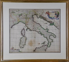
Antique Map of Italy, Showing Corsica, Sardinia, Croatia, Malta and More, C.1740
$658.98
£490.57
€550
CA$902.64
A$1,003.93
CHF 524.22
MX$12,216.75
NOK 6,695.09
SEK 6,278.82
DKK 4,186.96
Shipping
Retrieving quote...The 1stDibs Promise:
Authenticity Guarantee,
Money-Back Guarantee,
24-Hour Cancellation
About the Item
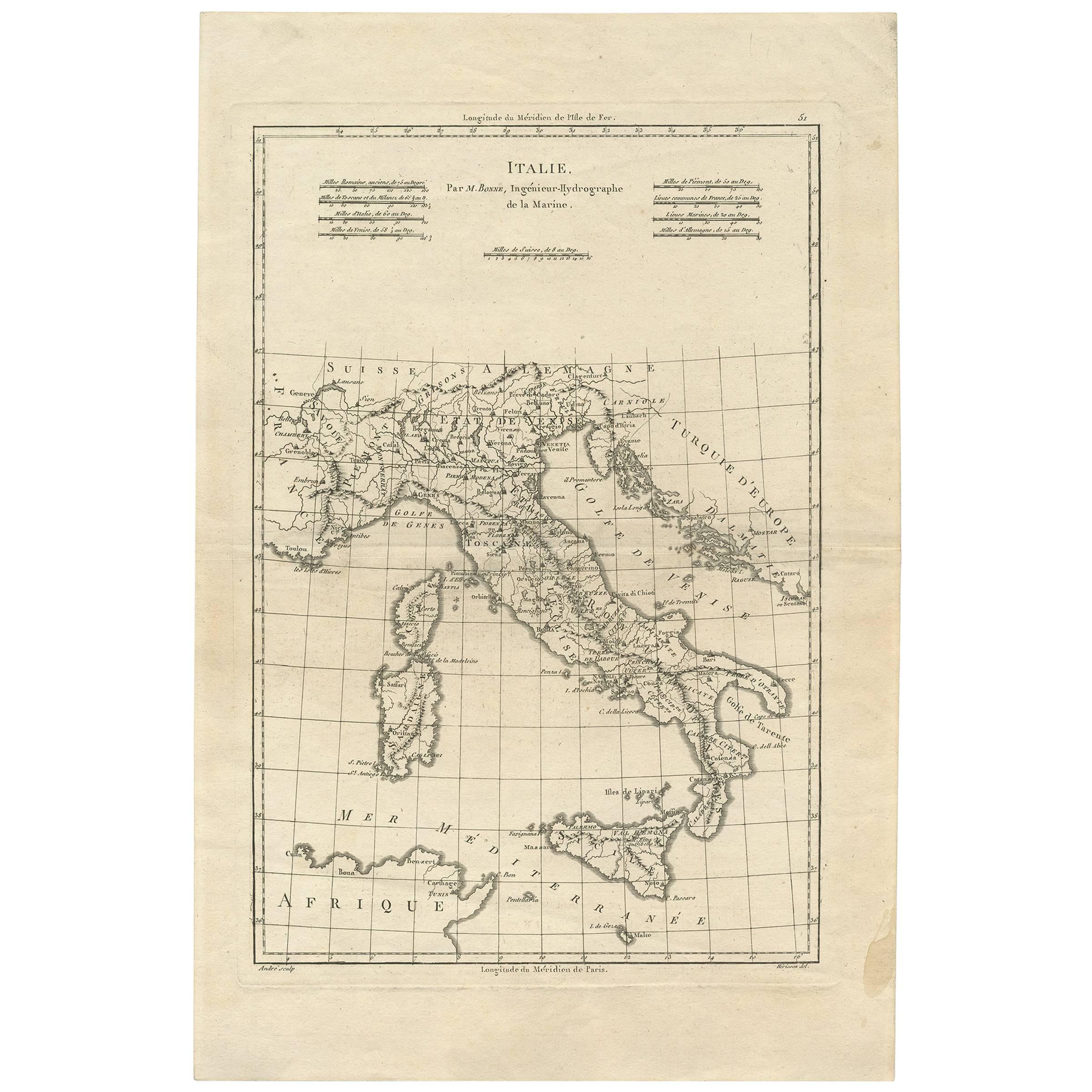
Antique map titled 'Nieuwe Kaart van Italie na de Nieuwste waarnemingen van de l'Isle en andere.'
Attractive detailed map showing Italy as well as Corsica, Sardinia, Minorca, Croatia, Albania, Dalmatia, a bit of Provence, Malta and the northern coast of Africa. The map is centered on a simple compass rose. Source unknown, to be determined. Artists and Engravers: Made by 'Isaak Tirion' after an anonymous artist. Made by 'Isaak Tirion' after an anonymous artist. Isaak Tirion, a Dutch publisher in Amsterdam, was born 1705. He produced serveral Atlases and Dutch town plans. The maps mainly based on those of Guillaume de l'Isle. He died in 1765.
Artist: Made by 'Isaak Tirion' after an anonymous artist. Made by 'Isaak Tirion' after an anonymous artist. Isaak Tirion, a Dutch publisher in Amsterdam, was born 1705. He produced serveral Atlases and Dutch town plans. The maps mainly based on those of Guillaume de l'Isle. He died in 1765.
Condition: Good, given age. Paper somewhat browned. Edges with an occasional tiny tear. A few minor spots. Original middle fold as issued. General age-related toning and/or occasional minor defects from handling. Please study image carefully.
Date: c.1740
Overall size: 55.3 x 43.5 cm.
Image size: 37.7 x 32.7 cm.
We sell original antique maps to collectors, historians, educators and interior decorators all over the world. Our collection includes a wide range of authentic antique maps from the 16th to the 20th centuries. Buying and collecting antique maps is a tradition that goes back hundreds of years. Antique maps have proved a richly rewarding investment over the past decade, thanks to a growing appreciation of their unique historical appeal. Today the decorative qualities of antique maps are widely recognized by interior designers who appreciate their beauty and design flexibility. Depending on the individual map, presentation, and context, a rare or antique map can be modern, traditional, abstract, figurative, serious or whimsical. We offer a wide range of authentic antique maps for any budget.
- Dimensions:Height: 21.78 in (55.3 cm)Width: 17.13 in (43.5 cm)Depth: 0 in (0.01 mm)
- Materials and Techniques:
- Period:
- Date of Manufacture:circa 1740
- Condition:Condition: Good, given age. Paper somewhat browned. Edges with an occasional tiny tear. A few minor spots. Original middle fold as issued. General age-related toning and/or occasional minor defects from handling. Please study image carefully.
- Seller Location:Langweer, NL
- Reference Number:Seller: PCT-592181stDibs: LU3054326359602
About the Seller
5.0
Recognized Seller
These prestigious sellers are industry leaders and represent the highest echelon for item quality and design.
Platinum Seller
Premium sellers with a 4.7+ rating and 24-hour response times
Established in 2009
1stDibs seller since 2017
2,510 sales on 1stDibs
Typical response time: <1 hour
- ShippingRetrieving quote...Shipping from: Langweer, Netherlands
- Return Policy
Authenticity Guarantee
In the unlikely event there’s an issue with an item’s authenticity, contact us within 1 year for a full refund. DetailsMoney-Back Guarantee
If your item is not as described, is damaged in transit, or does not arrive, contact us within 7 days for a full refund. Details24-Hour Cancellation
You have a 24-hour grace period in which to reconsider your purchase, with no questions asked.Vetted Professional Sellers
Our world-class sellers must adhere to strict standards for service and quality, maintaining the integrity of our listings.Price-Match Guarantee
If you find that a seller listed the same item for a lower price elsewhere, we’ll match it.Trusted Global Delivery
Our best-in-class carrier network provides specialized shipping options worldwide, including custom delivery.More From This Seller
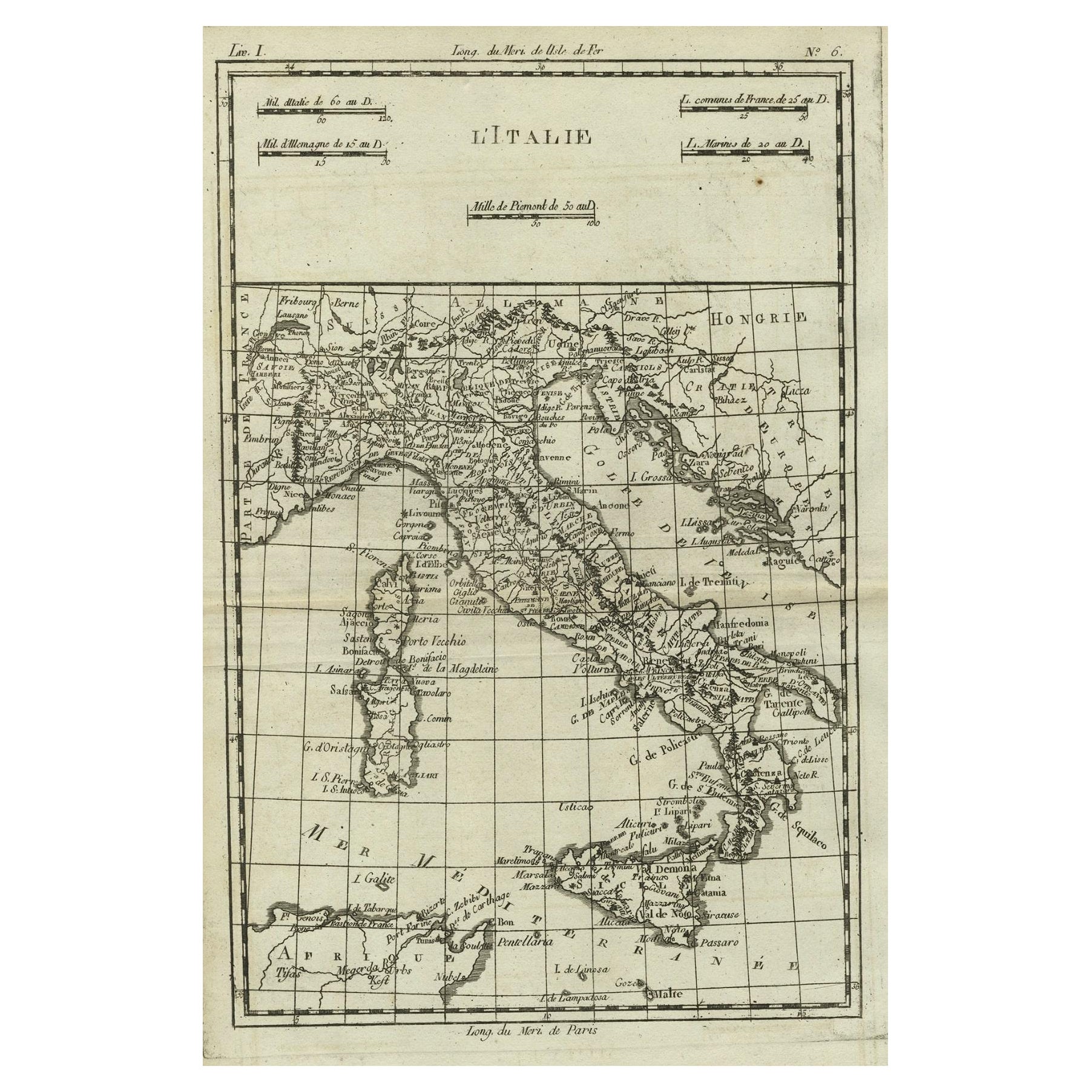
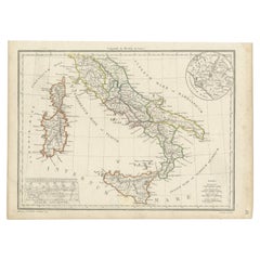
View AllAntique Map of Italy, Corsica, Sardinia and Sicily, ca.1780
Located in Langweer, NL
Description: Antique map titled 'L'Italie.'
Map of Italy, Corsica, Sardinia and Sicily. Highly detailed, showing towns, rivers, some topographical features and political boundari...
Category
Antique 1780s Maps
Materials
Paper

$306 Sale Price
20% Off
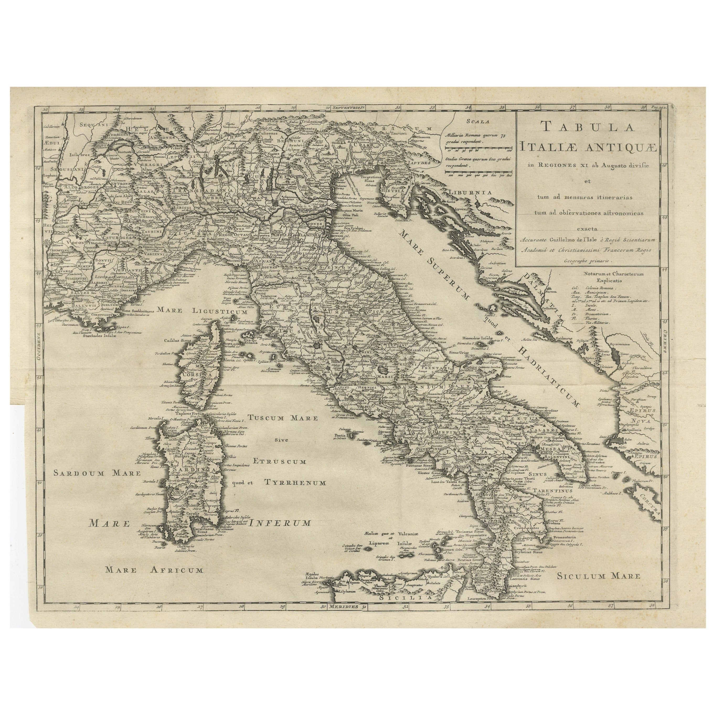
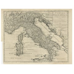
Antique Engraved Map of Italy in Roman Times, ca.1730
Located in Langweer, NL
Plain engr. map of Italy according to the division of Emperor Augustus by G. Delisle.
Title: "Tabula Italiae Antiquae In Regiones XI Ab Augusto Divisae Et Tum Ad Mensuras Itinerari...
Category
Antique 1730s Maps
Materials
Paper
$651 Sale Price
20% Off
Antique Map of Italy by Keizer & de Lat, 1788
Located in Langweer, NL
Antique map titled 'Kaart van Italie (..)'. Uncommon original antique map of Italy. This map originates from 'Nieuwe Natuur- Geschied- en Handelk...
Category
Antique Late 18th Century Maps
Materials
Paper

$313 Sale Price
25% Off
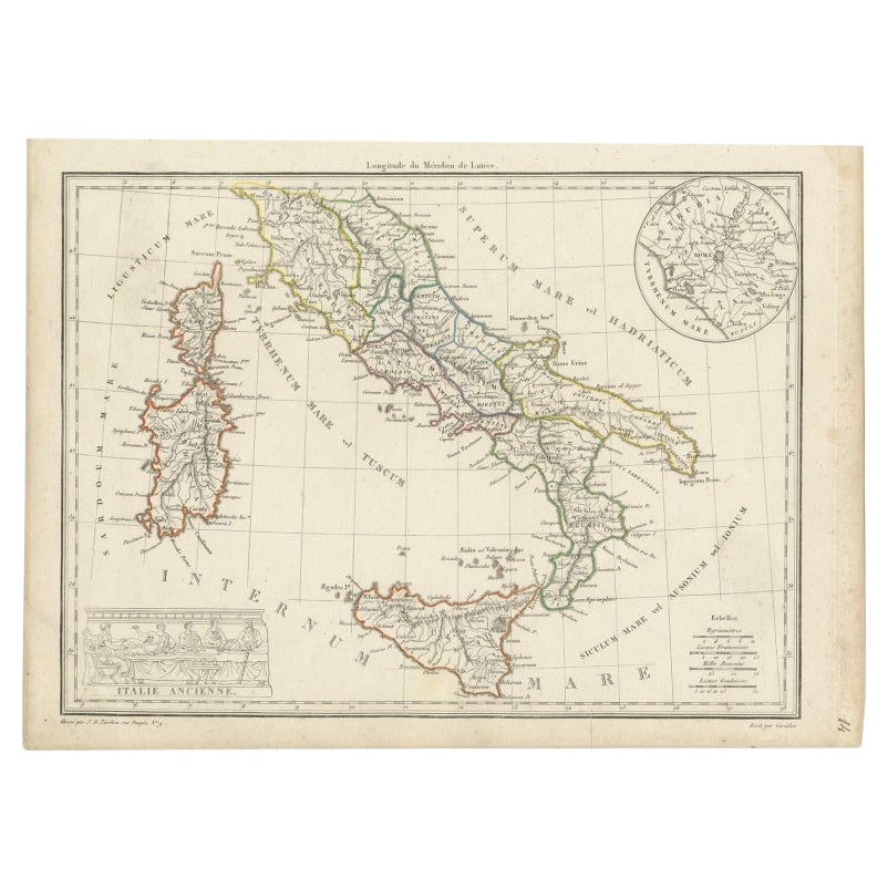
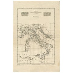
Antique Map of Italy with an Inset of Rome, 1812
Located in Langweer, NL
Antique map titled 'Italie Ancienne'.
Old map of ancient Italy, with an inset map of the region of Rome. This map originates from 'Atlas Supplementaire du Precis de la Geographie...
Category
Antique 19th Century Maps
Materials
Paper
$153 Sale Price
20% Off
Antique Map of Italy by R. Bonne, circa 1780
Located in Langweer, NL
Beautiful map of Italy, Corsica, Sardinia and Sicily. Highly detailed, showing towns, rivers, some topographical features and political boundaries. Published by R. Bonne, circa 1780.
Category
Antique Late 18th Century Maps
Materials
Paper
$287 Sale Price
20% Off
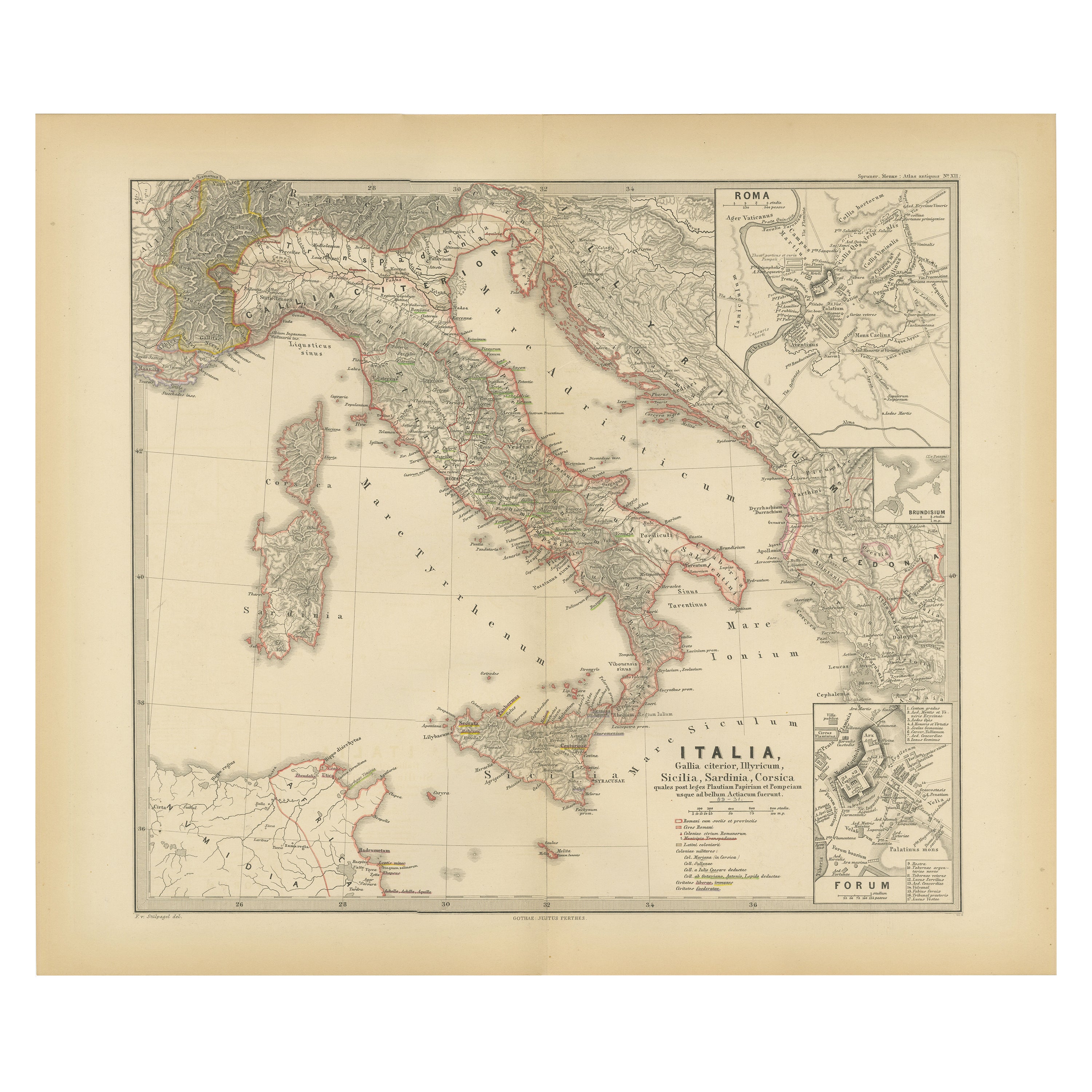
Map of The Italian Peninsula with the islands of Sicily, Sardinia, Corsica, 1880
Located in Langweer, NL
This map, titled "ITALIA, Sicilia, Sardinia, Corsica," represents the Italian Peninsula along with the islands of Sicily, Sardinia, and Corsica. Inset maps offer detailed views of "R...
Category
Antique 1880s Maps
Materials
Paper

$354 Sale Price
20% Off
Free Shipping
You May Also Like
Italy, Sicily, Sardinia, Corsica and Dalmatian Coast: A 17th Century Dutch Map
By Theodorus Danckerts
Located in Alamo, CA
This hand colored 17th century Dutch map entitled "Novissima et Accuratissima totius Italiae Corsicae et Sardiniae Descriptio" by Theodore Danckerts depicts the Italian Peninsula in ...
Category
Antique Late 17th Century Dutch Maps
Materials
Paper

17th Century Dutch Map of Italy, Sicily, Sardinia, Corsica and Dalmatian Coast
By Theodorus Danckerts
Located in Alamo, CA
This hand colored 17th century Dutch map entitled "Novissima et Accuratissima totius Italiae Corsicae et Sardiniae Descriptio" by Theodore Danckerts depicts the Italian Peninsula in ...
Category
1690s Prints and Multiples
Materials
Engraving
Large Original Antique Map of Italy. John Dower, 1861
Located in St Annes, Lancashire
Great map of Italy
Lithograph engraving by John Dower
Original colour
Published, 1861
Unframed
Good condition / repair to top right corner seen in last image
Category
Antique 1860s English Victorian Maps
Materials
Paper

The Kingdom of Naples and Southern Italy: A Hand-Colored 18th Century Homann Map
By Johann Baptist Homann
Located in Alamo, CA
"Novissima & exactissimus Totius Regni Neapolis Tabula Presentis Belli Satui Accommo Data" is a hand colored map of southern Italy and the ancient Kingdom of Naples created by Johann...
Category
Antique Early 18th Century German Maps
Materials
Paper

Antique Map of Italy Drawn & Engraved by R. Scott for Thomsons, Edinburgh 1814
Located in London, GB
This is a magnificent museum quality antique hand-coloured map of Italy, dating from 1814.
This historic and very rare antique map was drawn and engraved by R. Scott for Thomsons, New General Atlas, Edinburgh.
The map is very detailed and the various colours - yellow, grey and green - beautifully highlight the different natural and political divisions of Italy as it was before the Italian Unification...
Category
Antique 1810s Scottish Prints
Materials
Other

Large Original Antique Map of South Italy and Malta by Sidney Hall, 1847
Located in St Annes, Lancashire
Great map of South Italy and Malta
Drawn by Sidney Hall
Steel engraving by G.Aikman
Original color outline
Published by A & C Black. 1847
Un...
Category
Antique 1840s Scottish Maps
Materials
Paper

More Ways To Browse
Croatian Artist
Antique Maltese
Antique Maltese Furniture
Malta Antique
Albanian Antique
Croatian Antiques
18th Century Maltese Furniture
Sardinia Map
Croatia Map
Albania Antique Map
Antique Maps Of Malta
Vintage Glass Map
Antique Furniture Cyprus
Antique Linen Map
Caribbean Colonial Furniture
Antique Maps West Indies
California Island Map
Pirate Antique