Items Similar to Antique Map of the Location of the Garden of Eden and Travels of the Patriarchs

Want more images or videos?
Request additional images or videos from the seller
1 of 7
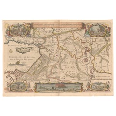
Antique Map of the Location of the Garden of Eden and Travels of the Patriarchs
$563.13
£419.21
€470
CA$771.34
A$857.90
CHF 447.97
MX$10,439.76
NOK 5,721.26
SEK 5,365.53
DKK 3,577.95
Shipping
Retrieving quote...The 1stDibs Promise:
Authenticity Guarantee,
Money-Back Guarantee,
24-Hour Cancellation
About the Item
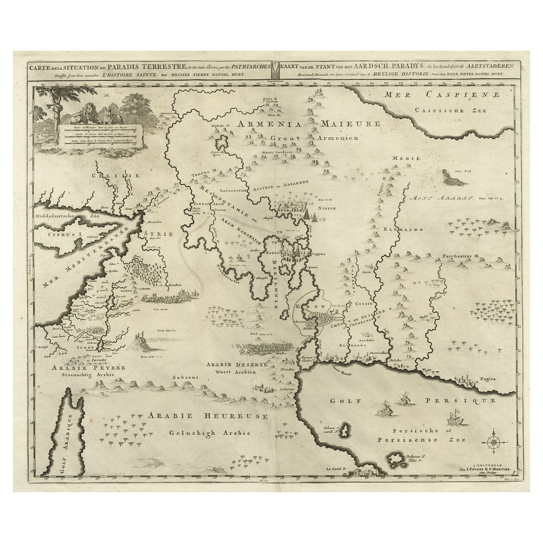
Title: Map of the Location of the Garden of Eden and Travels of the Patriarchs
Cartographer/Publisher:
Pieter Mortier (1661–1711), published by Covens & Mortier (Amsterdam, 1725)
Publication Details:
- First Appeared in: Histoire du Vieux et du Nouveau Testament
- Published by: Covens & Mortier
- Year: 1725
Description:
This intricately engraved map covers the Holy Land and the Middle East, centered on the presumed location of the Garden of Eden. It includes the Mediterranean coastline, the Persian Gulf, and the surrounding regions, with extensive details of ancient cities, biblical routes, and landmarks.
Notable Features:
- Focus on the Garden of Eden:
The map centers on the Garden of Eden, outlined in yellow, and showcases the biblical geography of the region.
- Cities and Landmarks:
Major cities and sites include Babylon, Ninive (Nineveh), Jerusalem, Antiocha (Antioch), Babel, and Suse (Susa).
- Patriarchs' Travels:
Routes of biblical patriarchs are marked, connecting various regions and cities.
- Large Cyprus:
The map features an oversized Cyprus, depicted prominently in the eastern Mediterranean.
- Decorative Details:
The map includes engraved depictions of cities, rivers, and mountain ranges, along with maritime features such as ships and compass roses.
Background Information:
The map first appeared in Histoire du Vieux et du Nouveau Testament, a compilation of biblical maps and narratives published by Covens & Mortier. The firm, founded in Amsterdam in 1721, was one of the largest Dutch publishing houses of the 18th century. They specialized in republishing and updating the works of earlier cartographers, including De L'Isle, Allard, and Jansson.
Pieter Mortier, the founder of the Mortier publishing empire, was a renowned mapmaker who combined French cartographic influences with Dutch engraving traditions. His works often featured detailed engravings and were widely respected for their artistic and geographical accuracy.
Condition:
The map is in good condition for its age, with vibrant hand-coloring and minimal signs of wear. The paper shows light age-toning around the edges, typical of 18th-century prints. The engraving and decorative elements are sharp and well-preserved.
Keywords:
Pieter Mortier map
Covens & Mortier map
Biblical map
Garden of Eden map
Holy Land cartography
Middle East map
18th-century cartography
Antique map
Travels of the Patriarchs
Decorative biblical map
- Dimensions:Height: 20.48 in (52 cm)Width: 24.41 in (62 cm)Depth: 0.01 in (0.2 mm)
- Materials and Techniques:Paper,Engraved
- Period:1720-1729
- Date of Manufacture:1725
- Condition:The map is in good condition for its age, with vibrant hand-coloring and minimal signs of wear. The paper shows light age-toning around the edges, typical of 18th-century prints. The engraving and decorative elements are sharp and well-preserved.
- Seller Location:Langweer, NL
- Reference Number:Seller: BG-14043-31stDibs: LU3054343433482
About the Seller
5.0
Recognized Seller
These prestigious sellers are industry leaders and represent the highest echelon for item quality and design.
Platinum Seller
Premium sellers with a 4.7+ rating and 24-hour response times
Established in 2009
1stDibs seller since 2017
2,510 sales on 1stDibs
Typical response time: <1 hour
- ShippingRetrieving quote...Shipping from: Langweer, Netherlands
- Return Policy
Authenticity Guarantee
In the unlikely event there’s an issue with an item’s authenticity, contact us within 1 year for a full refund. DetailsMoney-Back Guarantee
If your item is not as described, is damaged in transit, or does not arrive, contact us within 7 days for a full refund. Details24-Hour Cancellation
You have a 24-hour grace period in which to reconsider your purchase, with no questions asked.Vetted Professional Sellers
Our world-class sellers must adhere to strict standards for service and quality, maintaining the integrity of our listings.Price-Match Guarantee
If you find that a seller listed the same item for a lower price elsewhere, we’ll match it.Trusted Global Delivery
Our best-in-class carrier network provides specialized shipping options worldwide, including custom delivery.More From This Seller
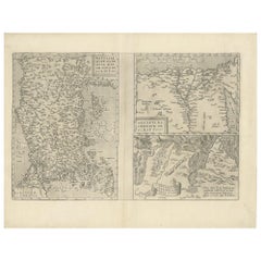
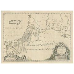
View AllBiblical Map of the Region from the Mediterranean through the Persian Gulf, 1720
Located in Langweer, NL
Antique map titled 'Carte de la Situation du Paradis Terrestre, Et des Pais Habitez par les Patriarches Dressee pour bien entendre l'Histoire Sainte, Par Messire Pierre Daniel Huet.'
This interesting map covers the region from the Mediterranean through the Persian Gulf. Detail is omitted in favor of Biblical depictions including the Sermon on the Mount...
Category
Antique 1720s Maps
Materials
Paper
$460 Sale Price
20% Off
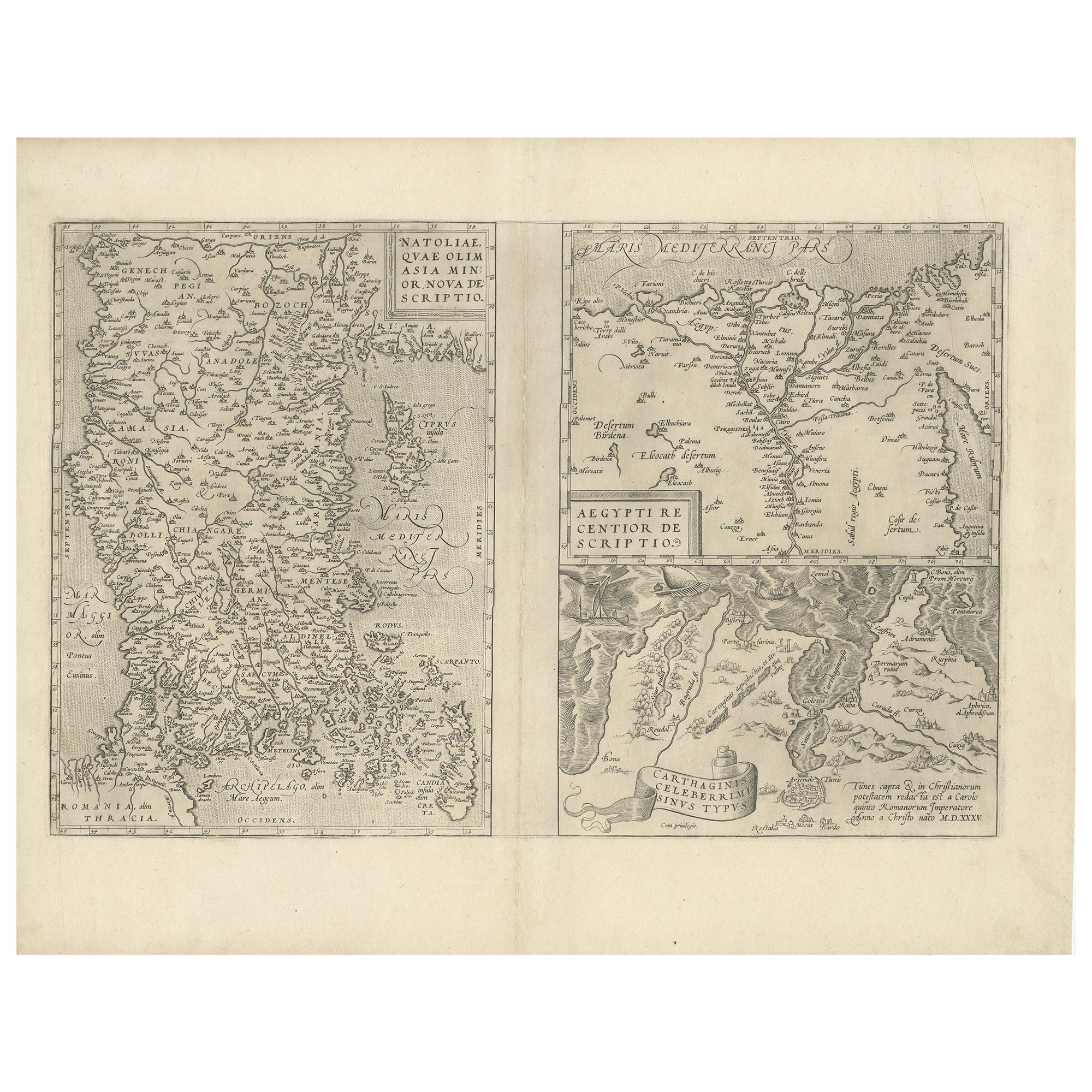
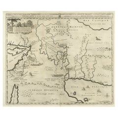
Antique Map of Asia Minor, Region of the Nile and Region of the City of Carthage
Located in Langweer, NL
Three antique maps on one sheet titled 'Natoliae quae olim Asia Minor [with] Aegypti recentior descriptio [with] Carthaginis Celeberrimisinus Typus'. The first map covers Asia Minor,...
Category
Antique 16th Century Maps
Materials
Paper
$479 Sale Price
20% Off
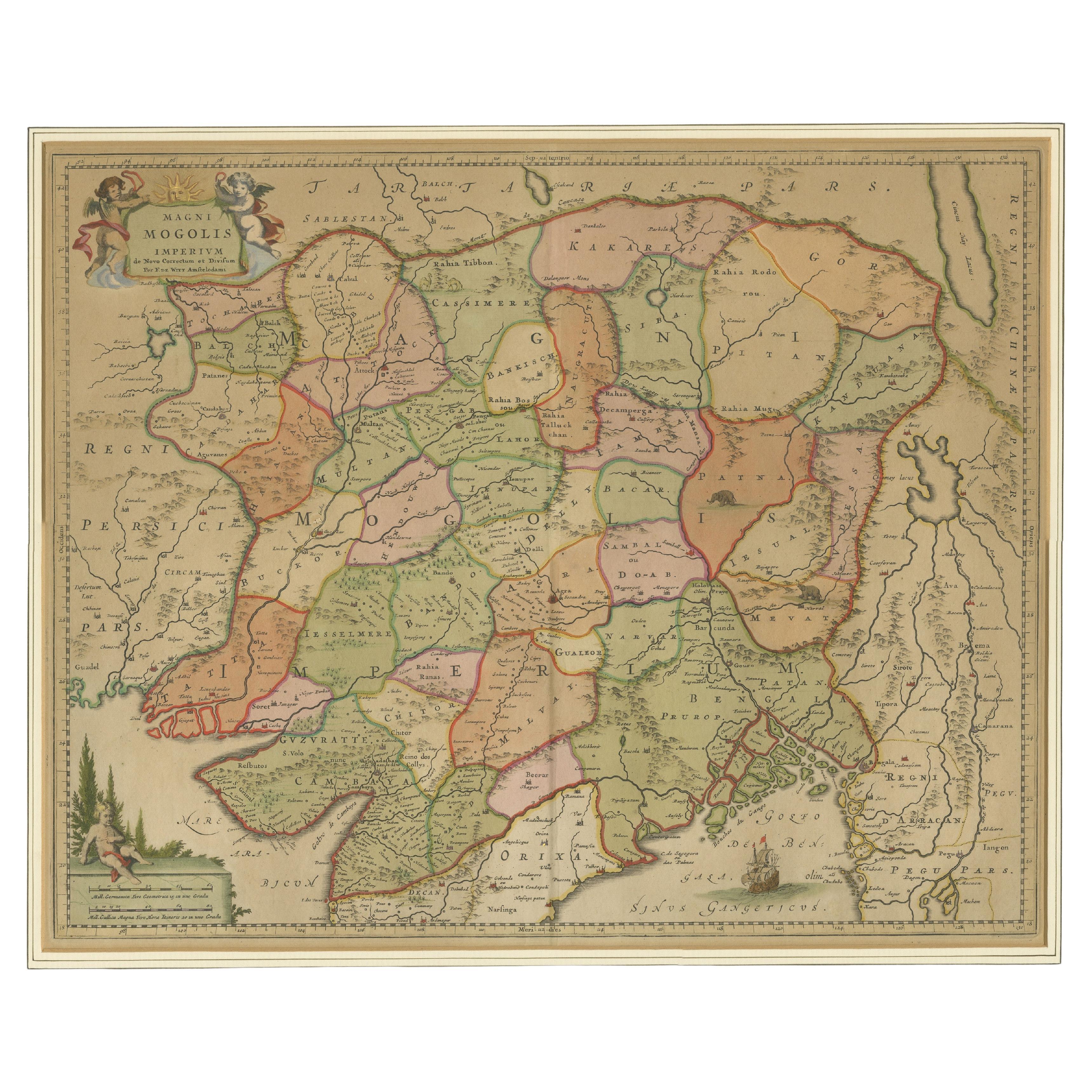
Antique Map of the Empire of the Great Mogul
Located in Langweer, NL
Antique map titled 'Magni Mogolis Imperium'. This map depicts the Empire of the Great Mogul in northern India including the region from Iran to Burma. The Indus and Ganges Rivers are...
Category
Antique Late 17th Century Maps
Materials
Paper
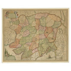
$920 Sale Price
20% Off
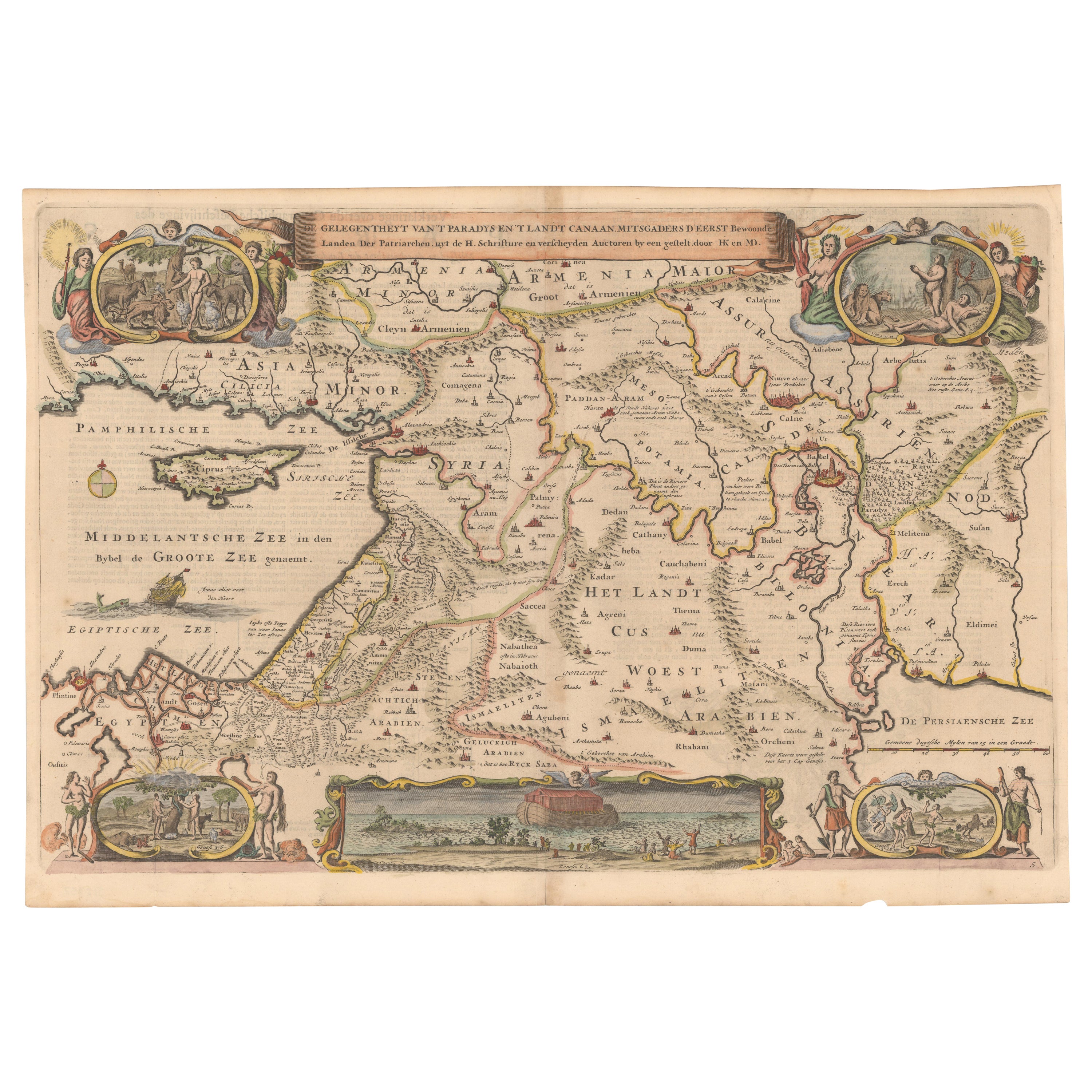
Circa 1686 Daniel Stoopendaal Map: Biblical Sites from Paradise to Canaan
Located in Langweer, NL
Circa 1686 Daniel Stoopendaal Map: Biblical Sites from Paradise to Canaan
This circa 1686 hand-colored map by Daniel Stoopendaal, titled "De Gelegentheyt van 't Paradys en 't Landt Canaan," beautifully illustrates the Middle East, extending from the Mediterranean to the Persian Gulf.
The map features numerous Biblical locations, such as the Garden of Eden, the wanderings of the Children of Israel, and the story of Jonas and the whale.
It is adorned with elaborate decorations, including a banner-style title cartouche and four corner vignettes depicting scenes from Genesis: Paradise, the creation of Adam and Eve, Eve offering the apple, and their expulsion from Eden.
The bottom center showcases a dramatic portrayal of Noah's Ark. Measuring 18.3 inches wide by 11.9 inches high, this first state map includes Dutch text on the reverse and is in good condition, with a crisp impression, light toning along the centerfold, and a small chip in the bottom margin.
Keywords:
- Daniel Stoopendaal map
- Biblical map
- Garden of Eden
- Land of Canaan
- Middle East historical map
- Noah's Ark map
- Adam and Eve
- 17th-century Bible...
Category
Antique 1680s Maps
Materials
Paper
$805 Sale Price
20% Off
Antique Bible Map of the Middle East by A. Schut, 1743
Located in Langweer, NL
Antique map titled 'De Gelegentheyt van 't Paradys en 't Landt Canaan'. Dutch Bible map covering the region between the Mediterranean and the Persian Gulf, ...
Category
Antique Mid-18th Century Maps
Materials
Paper

$527 Sale Price
20% Off
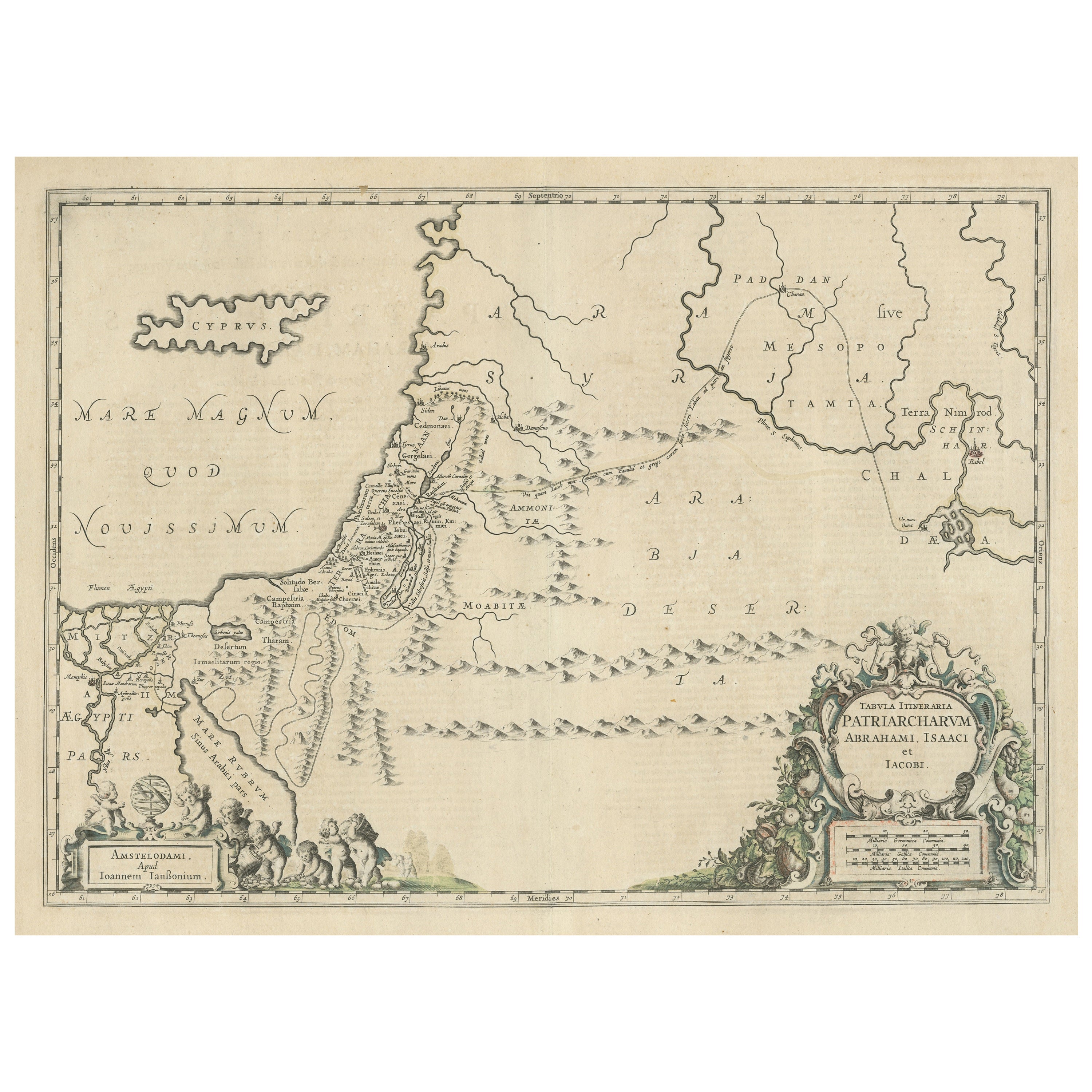
Antique Map of the Holy Land, showing the travels of Abraham, Isaac and Jacob
Located in Langweer, NL
Antique map titled 'Tabula Itineraria Patriarcharum Abrahami, Isaaci et Iacobi'. Decorative regional map of the Holy Land, showing the travels of Abraham, Isaac and Jacob. Published ...
Category
Antique Mid-17th Century Maps
Materials
Paper
$537 Sale Price
20% Off
You May Also Like
1633 Map "La Souverainete De Sedan Et De Raucourt, Et La Prevoste Ric0011
Located in Norton, MA
1653 map entitled
"La Souverainete de Sedan et de Raucourt, et la Prevoste de Doncheri,"
Ric0011
Description:
Lovely map centered on Sedan and Doncheri and the Meuze River fr...
Category
Antique 17th Century Dutch Maps
Materials
Paper

Antique French Map of Asia Including China Indoneseia India, 1783
Located in Amsterdam, Noord Holland
Very nice map of Asia. 1783 Dedie au Roy.
Additional information:
Country of Manufacturing: Europe
Period: 18th century Qing (1661 - 1912)
Condition: Overall Condition B (Good Used)...
Category
Antique 18th Century European Maps
Materials
Paper

$648 Sale Price
20% Off
1627 Hendrik Hondius Map Entitled "Vltoniae Orientalis Pars, " Ric.a009
Located in Norton, MA
1627 Hendrik Hondius map entitled
"Vltoniae orientalis pars,"
Ric.a009
Title:
Vltoniae orientalis : pars
Title (alt.) :
Ultoniae orientalis pars
Creator:
Mercator, Gerh...
Category
Antique 17th Century Dutch Maps
Materials
Paper

1714 Henri Chatelain "Nouvelle Carte Des Etatas Du Grand.Duc De Mos Moscovie Eur
Located in Norton, MA
A 1714 Henri Chatelain map, entitled
"Nouvelle Carte Des Etatas Du Grand Duc De Moscovie En Europe,"
Ricb001
Henri Abraham Chatelain (1684-1743) was a Huguenot pastor of Parisi...
Category
Antique Early 18th Century Dutch Maps
Materials
Paper

1654 Joan Blaeu Map the Sutherland, Scotland, Entitled "Southerlandia, "Ric0007
Located in Norton, MA
1654 Joan Blaeu map of the
Sutherland, Scotland, entitled
"Southerlandia,"
Hand Colored
Ric0007
Description:
Lovely map centered on Sedan and D...
Category
Antique 17th Century Dutch Maps
Materials
Paper

1718 Ides & Witsen Map "Route D'amsterdam a Moscow Et De La Ispahan Et Gamron
Located in Norton, MA
1718 Ides & Witsen map, entitled
"Route D'Amsterdam A Moscow Et De La Ispahan Et Gamron,"
Ric.b005
Subject: Eastern Europe and Central Asia
Period: 1718 (published)
Publicati...
Category
Antique Early 18th Century Dutch Maps
Materials
Paper

More Ways To Browse
Ancient Babylon
Carlo Scarpa 1934 Chairs
Christofle Marly
1900 Antique Chairs
Glass Table Italian Round
Alvar Aalto Poster
Geometric Metal Table
Post Modern High Chairs
Vintage Vine Rug
Cancel An Order
Antique Framing Square
Silver Metal Chair
Swedish Kilim
Vintage Scandanavian Chairs
Vintage Tropical Furniture
19th Century Red Glass
Antique French Console Table Tables
French 50s