Items Similar to Antique Map of the Mediterranean Sea and Surroundings by Keizer & de Lat, 1788


Want more images or videos?
Request additional images or videos from the seller
1 of 5
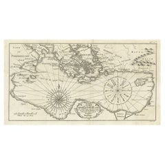
Antique Map of the Mediterranean Sea and Surroundings by Keizer & de Lat, 1788
$332.02
$415.0320% Off
£247.48
£309.3520% Off
€280
€35020% Off
CA$455.63
CA$569.5420% Off
A$510.18
A$637.7320% Off
CHF 266.19
CHF 332.7420% Off
MX$6,216.21
MX$7,770.2720% Off
NOK 3,377.74
NOK 4,222.1720% Off
SEK 3,211.33
SEK 4,014.1620% Off
DKK 2,131.82
DKK 2,664.7720% Off
Shipping
Retrieving quote...The 1stDibs Promise:
Authenticity Guarantee,
Money-Back Guarantee,
24-Hour Cancellation
About the Item
Antique map titled 't Wester Deel van de Middelandse Zee (..)'. Uncommon original antique map of the Mediterranean Sea and surroundings. This map originates from 'Nieuwe Natuur- Geschied- en Handelkundige Zak- en Reisatlas' by Gerrit Brender à Brandis. Published by J. Keizer and I. de Lat, 1788.
- Dimensions:Height: 8.08 in (20.5 cm)Width: 12.6 in (32 cm)Depth: 0.02 in (0.5 mm)
- Materials and Techniques:
- Period:
- Date of Manufacture:1788
- Condition:General age-related toning. Original folding lines. Original/contemporary hand coloring, blank verso. Minor wear, please study image carefully.
- Seller Location:Langweer, NL
- Reference Number:Seller: BG-12854-151stDibs: LU3054321978802
About the Seller
5.0
Recognized Seller
These prestigious sellers are industry leaders and represent the highest echelon for item quality and design.
Platinum Seller
Premium sellers with a 4.7+ rating and 24-hour response times
Established in 2009
1stDibs seller since 2017
2,493 sales on 1stDibs
Typical response time: <1 hour
- ShippingRetrieving quote...Shipping from: Langweer, Netherlands
- Return Policy
Authenticity Guarantee
In the unlikely event there’s an issue with an item’s authenticity, contact us within 1 year for a full refund. DetailsMoney-Back Guarantee
If your item is not as described, is damaged in transit, or does not arrive, contact us within 7 days for a full refund. Details24-Hour Cancellation
You have a 24-hour grace period in which to reconsider your purchase, with no questions asked.Vetted Professional Sellers
Our world-class sellers must adhere to strict standards for service and quality, maintaining the integrity of our listings.Price-Match Guarantee
If you find that a seller listed the same item for a lower price elsewhere, we’ll match it.Trusted Global Delivery
Our best-in-class carrier network provides specialized shipping options worldwide, including custom delivery.More From This Seller
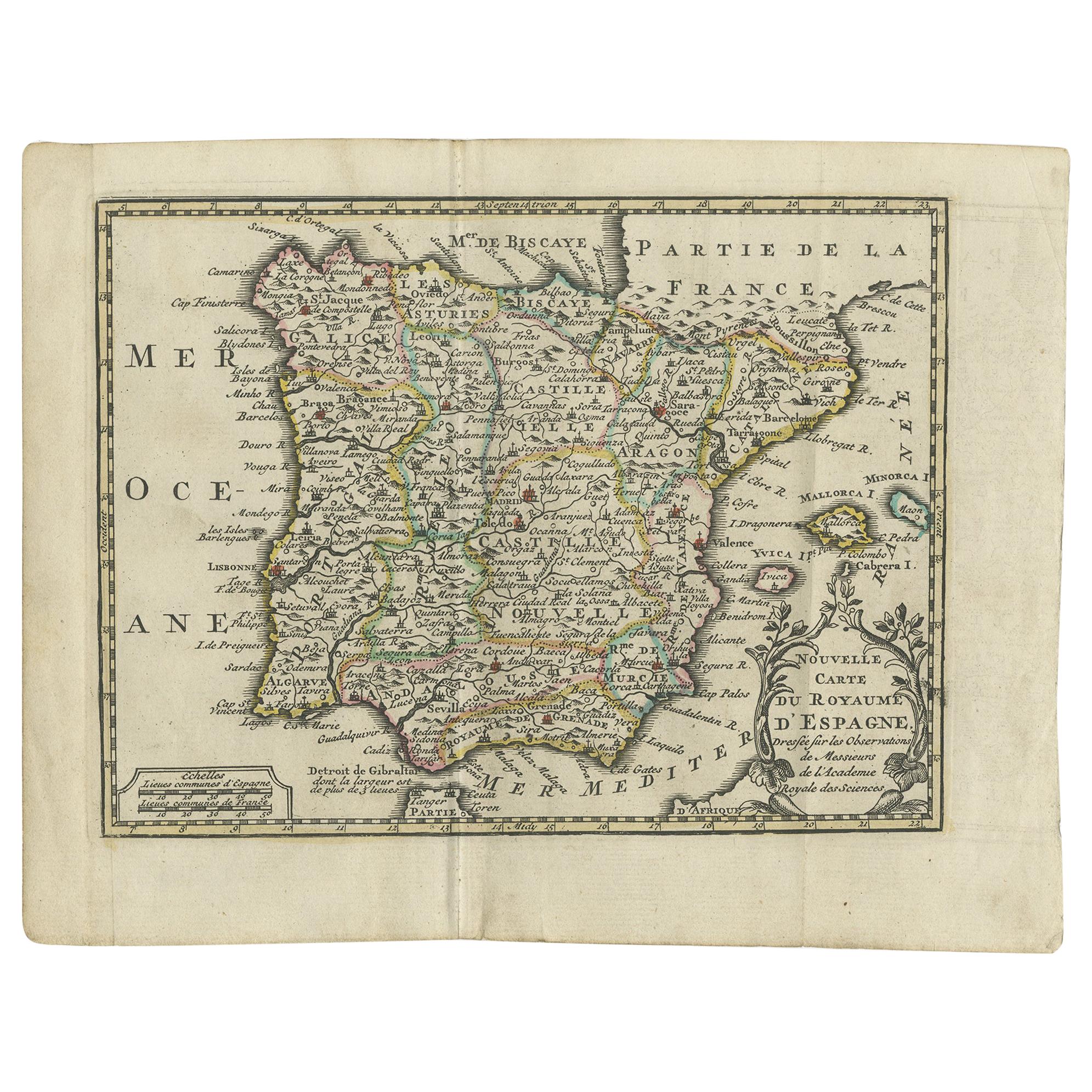
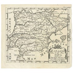
View AllAntique Map of Spain and Portugal by Keizer & de Lat, 1788
Located in Langweer, NL
Antique map titled 'Nouvelle Carte du Royaume d'Espagne (..)'. Uncommon original antique map of Spain and Portugal. This map originates from 'Nieuwe Natuur- Geschied- en Handelkundig...
Category
Antique Late 18th Century Maps
Materials
Paper

$332 Sale Price
20% Off
Antique Map of the Northern Coast of Africa and Southern Europe, circa 1745
By Covens & Mortier
Located in Langweer, NL
Antique map titled 'In Notitiam Ecclesiasticam Africae Tabula Geographica'. Very decorative hand-colored map of the northern coast of Africa, Spain, Italy and the Mediterranean with the islands of Sardinia, Corsica, Majorca, Minorca etc. Sicily features a smoking Mount Aetna. Embellished with three architectural cartouches...
Category
Antique Mid-18th Century Maps
Materials
Paper

$303 Sale Price
67% Off
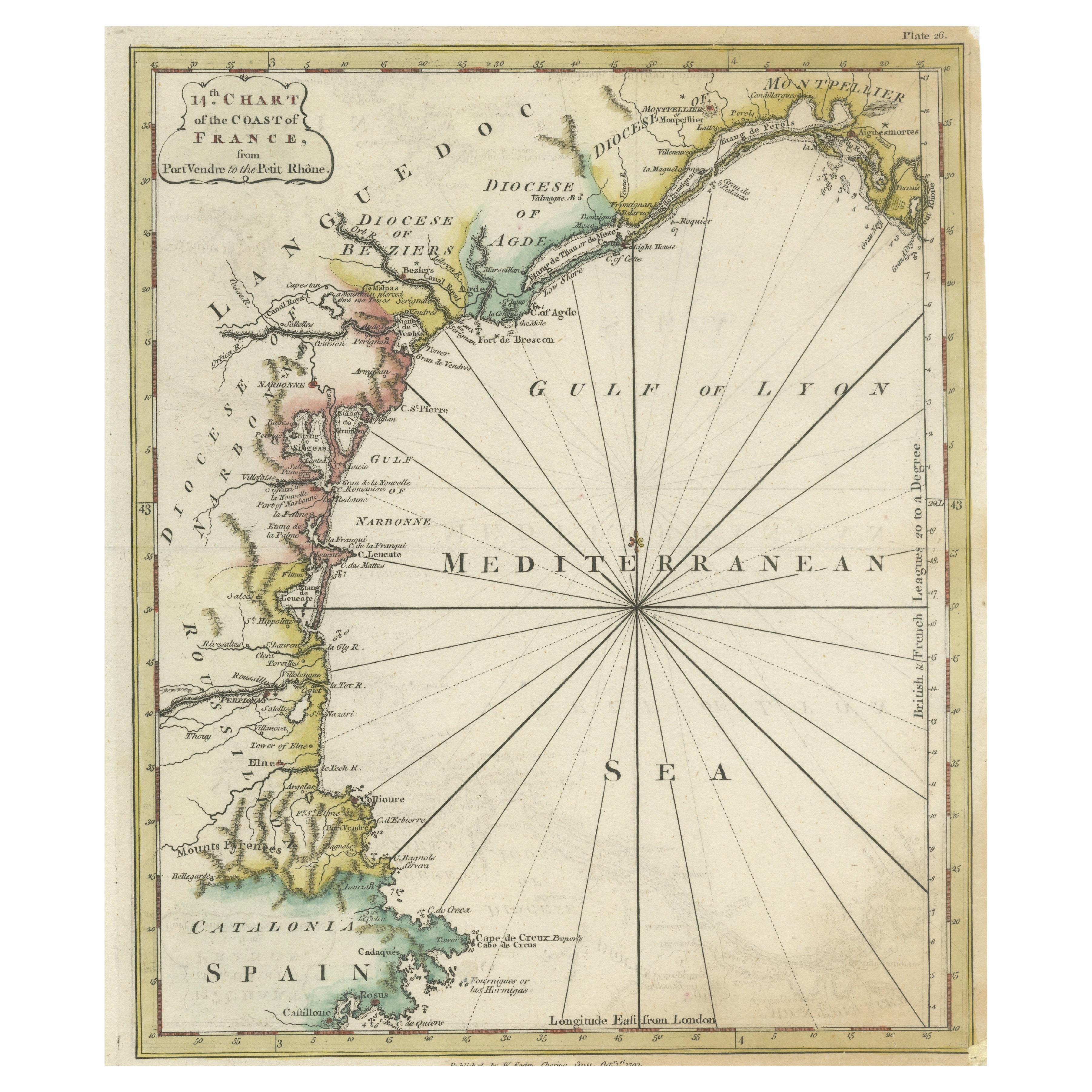
Antique Map of the Coast of Southern France, 1793
Located in Langweer, NL
Antique map titled '14th Chart of the Coast of France, from Port Vendres to the Petit Rhône'. Original map with later hand coroling of the coast of Southern France.
The "14th Chart of the Coast of France, from Port Vendres to the Petit Rhône" is an antique map that offers a detailed depiction of the southern coast of France, specifically highlighting the Mediterranean coastline. This map, which dates back to 1793, was originally part of "Le Petit Neptune Français; Or, French Coasting Pilot," a publication designed for maritime navigation along the French coastlines.
Key Features of the Map:
1. **Geographic Coverage**:
- The map covers the southern French coastline from Port Vendres in the west to the Petit Rhône in the east.
- It includes notable regions such as Languedoc, the Gulf of Lyon, and parts of Catalonia (Spain).
2. **Notable Places**:
- **Montpellier**: A major city in the Diocese of Montpellier, an important cultural and economic center.
- **Narbonne**: Located in the Diocese of Narbonne, a historical city with Roman heritage.
- **Agde**: Situated in the Diocese of Agde, known for its ancient Greek colony origins.
- **Béziers**: Part of the Diocese of Béziers, another city with deep historical roots dating back to Roman times.
- **Port Vendres**: A critical port near the Spanish border.
- **Catalonia**: Including parts of northeastern Spain, emphasizing the coastal connection between France and Spain.
3. **Dioceses and Regions**:
- The map is marked with various dioceses such as Montpellier, Agde, Narbonne, and Béziers, indicating ecclesiastical boundaries.
- It highlights the broader region of Languedoc, a historical province known for its wine production and medieval history.
4. **Navigational Aids**:
- The map features a compass rose with radiating lines, a common navigational aid in maritime maps...
Category
Antique Late 18th Century Maps
Materials
Paper

$227 Sale Price
20% Off
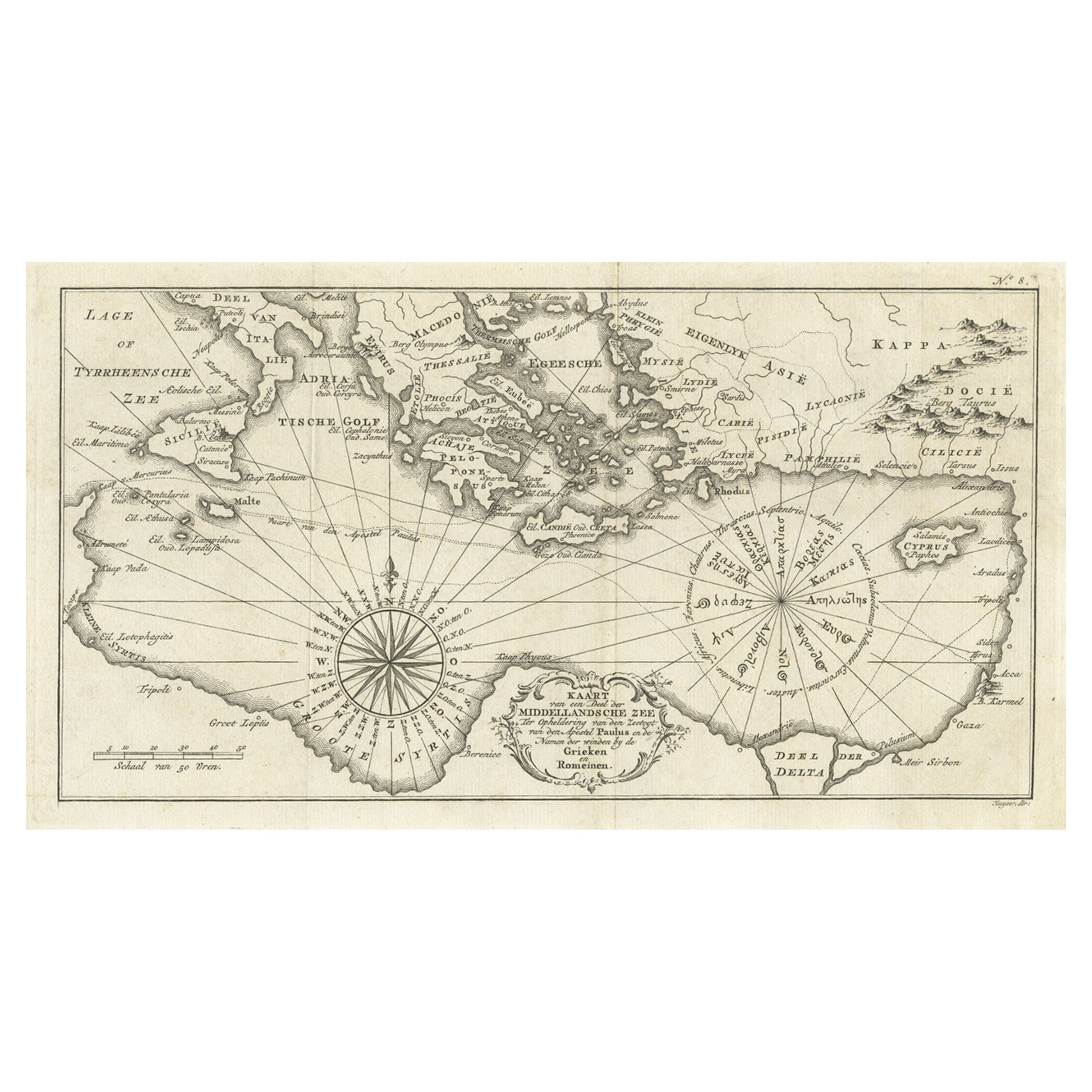
Old Dutch Map of the Region Around the Mediterranean Sea, 1773
Located in Langweer, NL
Antique map titled 'Kaart van een Deel der Middelandsche Zee (..)'.
Old map of the region around the Mediterranean Sea. Originates from the first Dutch editon of an interesting t...
Category
Antique 1770s Maps
Materials
Paper
$341 Sale Price
20% Off
Antique Map of Europe by Keizer & de Lat, 1788
Located in Langweer, NL
Antique map titled 'Kaartje van Europa (..)'. Uncommon original antique map of Europe. This map originates from 'Nieuwe Natuur- Geschied- en Handelkundige Zak- en Reisatlas' by Gerri...
Category
Antique Late 18th Century Maps
Materials
Paper

$379 Sale Price
20% Off
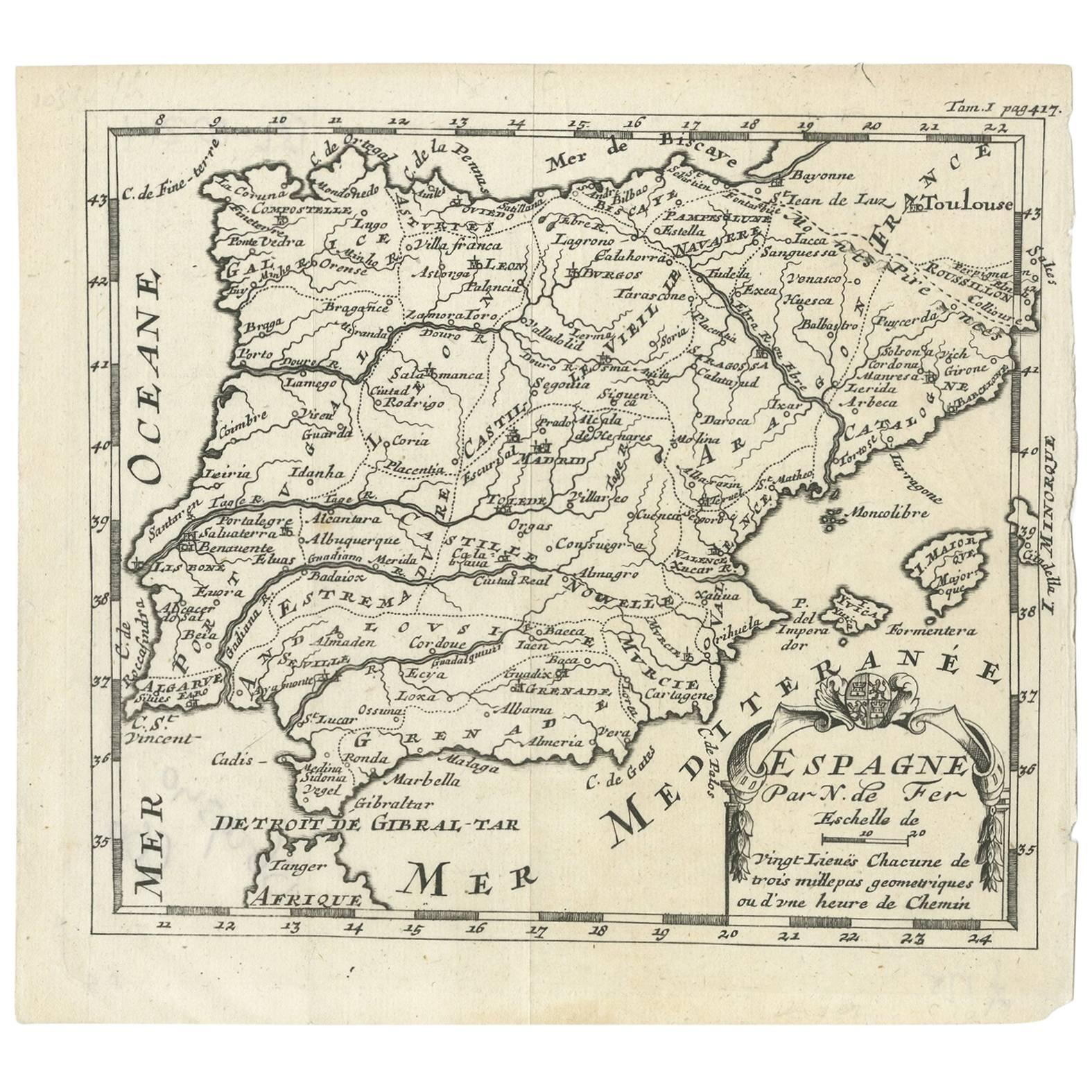
Antique Map of Spain by N. de Fer, circa 1700
Located in Langweer, NL
Antique map of Spain and Portugal with a title cartouche. Nicolas de Fer was the youngest son of the Paris printer and publisher Antoine de Fer. At the ...
Category
Antique Early 18th Century Maps
Materials
Paper
$151 Sale Price
20% Off
You May Also Like
Original Antique Map of Spain and Portugal, circa 1790
Located in St Annes, Lancashire
Super map of Spain and Portugal
Copper plate engraving by A. Bell
Published, circa 1790.
Unframed.
Category
Antique 1790s English Other Maps
Materials
Paper

18th Century Hand Colored Map of Spain and Portugal by Visscher
By Nicolaes Visscher II
Located in Alamo, CA
This is an early 18th century map of Spain and Portugal, with attractive original hand-coloring, entitled "Hispaniae et Portugalliae Regna per Nicolaum Visscher cum Privilegio Ordinu...
Category
Antique Early 18th Century Dutch Maps
Materials
Paper

Mediterranean and Adriatic Seas: Original 18th Century Hand-colored Map by Bowen
Located in Alamo, CA
This is an original 18th century hand-colored map entitled "An Accurate Chart of The Mediterranean and Adriatic Sea's; with the Archipelago & Part of the Black Sea. Exhibiting all th...
Category
Mid-18th Century Old Masters Landscape Prints
Materials
Engraving

Southern Greece: A Large 17th C. Hand-colored Map by Sanson and Jaillot
By Nicolas Sanson
Located in Alamo, CA
This large original hand-colored copperplate engraved map of southern Greece and the Pelopponese Peninsula entitled "La Moree Et Les Isles De Zante, Cefalonie, Ste. Marie, Cerigo & C...
Category
Antique 1690s French Maps
Materials
Paper

1751 Map of Spain Castilla Robert De Vaugondy 1st Edition, Ric.a001
Located in Norton, MA
Large Spain Castilla Robert De Vaugondy
1751 1st Edition
-Colored- Ric.a001
Coming from a family of cartographers, a descendant of the famous Nicolas Sanson and ordinary geographer of the king, Gilles Robert de Vaugondy makes himself known by his maps of the French provinces.
He published an Essay on the History of Geography (1755) from which he excluded the physical geography "too systematic". After a Small Atlas (1748), he draws a universal Atlas (1758), a portable Atlas (1762).
His Atlas of the revolutions of the globe remains unpublished. His warnings and prefaces, his book reviews reveal a Cartesian mind and solid knowledge.
Very early, he associates with his works his son Didier who publishes, since 1742, the methodical tables of Nicolas Sanson, two Globes, one terrestrial, the other celestial (1752).
He is credited with a map of Poland...
Category
Antique 18th Century Unknown Maps
Materials
Paper

Hand-Colored 18th Century Homann Map of the Black Sea, Turkey and Asia Minor
By Johann Baptist Homann
Located in Alamo, CA
An attractive original early 18th century hand-colored map of the Black Sea and Turkey entitled "Carte de L'Asie Minevre ou de la Natolie et du Pont Evxin Tiree des Voyages et des Ob...
Category
Antique Early 18th Century German Maps
Materials
Paper

More Ways To Browse
Antique Mediterranean Map
Framed World Map
Rare Compass
16th Century Scotland
Antique Wood Coat Of Arms
Antique Maps Australia
Antique Quadrant
Caribbean Antique Furniture
Antique Native American Collectibles
Turkey Map
Map Of Austria
Antique Mediterranean Map
Antique Furniture Building Plans
Map Of Ireland
18th Century Compass
18th Century Maps America
Map Of Great Britain
Miniature Maps