Items Similar to Antique Map of Paris, "Carte Routiere des Environs de Paris" 1841


Want more images or videos?
Request additional images or videos from the seller
1 of 5
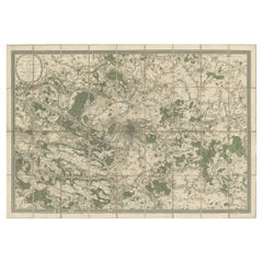
Antique Map of Paris, "Carte Routiere des Environs de Paris" 1841
$3,250
£2,467.80
€2,822.12
CA$4,540.72
A$5,050.27
CHF 2,637.10
MX$61,456.45
NOK 33,679.74
SEK 31,585.65
DKK 21,062.53
Shipping
Retrieving quote...The 1stDibs Promise:
Authenticity Guarantee,
Money-Back Guarantee,
24-Hour Cancellation
About the Item
This beautiful hand-colored road map of Paris was published in 1841. The map shows Paris and the surrounding area in a folding pocket map. Organized and detailed for travelers, this map shows rivers, towns, parks, and numbered roadways. Along the edges are depictions of the most famous tourist attractions around the city including Notre Dame, The Palace of Versailles, and the Hermitage of Jean-Jacques Rousseau. Originally, this map would have neatly folded into the small and portable cover on the left titled, “The New Road Map.”
Published during the July Monarchy, this map shows the city as it was in between two revolutions: the July Revolution and the 1848 Revolution. The Wall of the Ferme Générale surrounds the gray center of Paris, as the map clearly shows, however, that wall was soon replaced by the planned Thiers Wall shown in red. The Ferme Générale wall was not defensive, but meant to enforce import tax on goods entering the city. In 1841, the same year this map was published, construction began for the Thiers Wall that served as the last defensive wall around Paris. When the wall was proposed to the French Parliament, many saw it as a way to protect the monarchy in the event of another revolution rather than a way to protect the French people. Only seven years after this pocket map included the plans for the wall, the 1848 Revolution overthrew the monarchy despite the fortification. After WWI, the Thiers wall was rendered useless in the face of modern warfare technology and was dismantled between 1919 and 1929.
This map is not only an interesting snapshot amidst the rapid changes of the 19th century, but it would also have been extremely useful to all travelers at the time. Numbered road systems and recommended attractions helped the average tourist navigate the city and make the most of their visit to one of the largest cities in Europe.
Condition:
Overall very good condition. The 1841 map has some very light soiling as expected with age, but the colors are still vibrant. Horizontal and vertical creases throughout from where the map would have folded into the booklet. The booklet shows some signs of use with minor stains and distressed edges. Presented with the booklet cover, this map is archivally framed and protected with non-acidic matting and UV protective glass.
Framed dimensions: 38 1/8" H x 47 1/8" W x 1 1/4" D.
- Dimensions:Height: 38.13 in (96.86 cm)Width: 47.13 in (119.72 cm)Depth: 1.25 in (3.18 cm)
- Materials and Techniques:
- Place of Origin:
- Period:
- Date of Manufacture:1841
- Condition:Wear consistent with age and use. Overall very good condition. The 1841 map has some very light soiling as expected with age, but the colors are still vibrant. Horizontal and vertical creases throughout from where the map would have folded into the booklet.
- Seller Location:Colorado Springs, CO
- Reference Number:Seller: M0301stDibs: LU909717872711
About the Seller
4.9
Platinum Seller
Premium sellers with a 4.7+ rating and 24-hour response times
Established in 2010
1stDibs seller since 2011
461 sales on 1stDibs
- ShippingRetrieving quote...Shipping from: Colorado Springs, CO
- Return Policy
Authenticity Guarantee
In the unlikely event there’s an issue with an item’s authenticity, contact us within 1 year for a full refund. DetailsMoney-Back Guarantee
If your item is not as described, is damaged in transit, or does not arrive, contact us within 7 days for a full refund. Details24-Hour Cancellation
You have a 24-hour grace period in which to reconsider your purchase, with no questions asked.Vetted Professional Sellers
Our world-class sellers must adhere to strict standards for service and quality, maintaining the integrity of our listings.Price-Match Guarantee
If you find that a seller listed the same item for a lower price elsewhere, we’ll match it.Trusted Global Delivery
Our best-in-class carrier network provides specialized shipping options worldwide, including custom delivery.More From This Seller
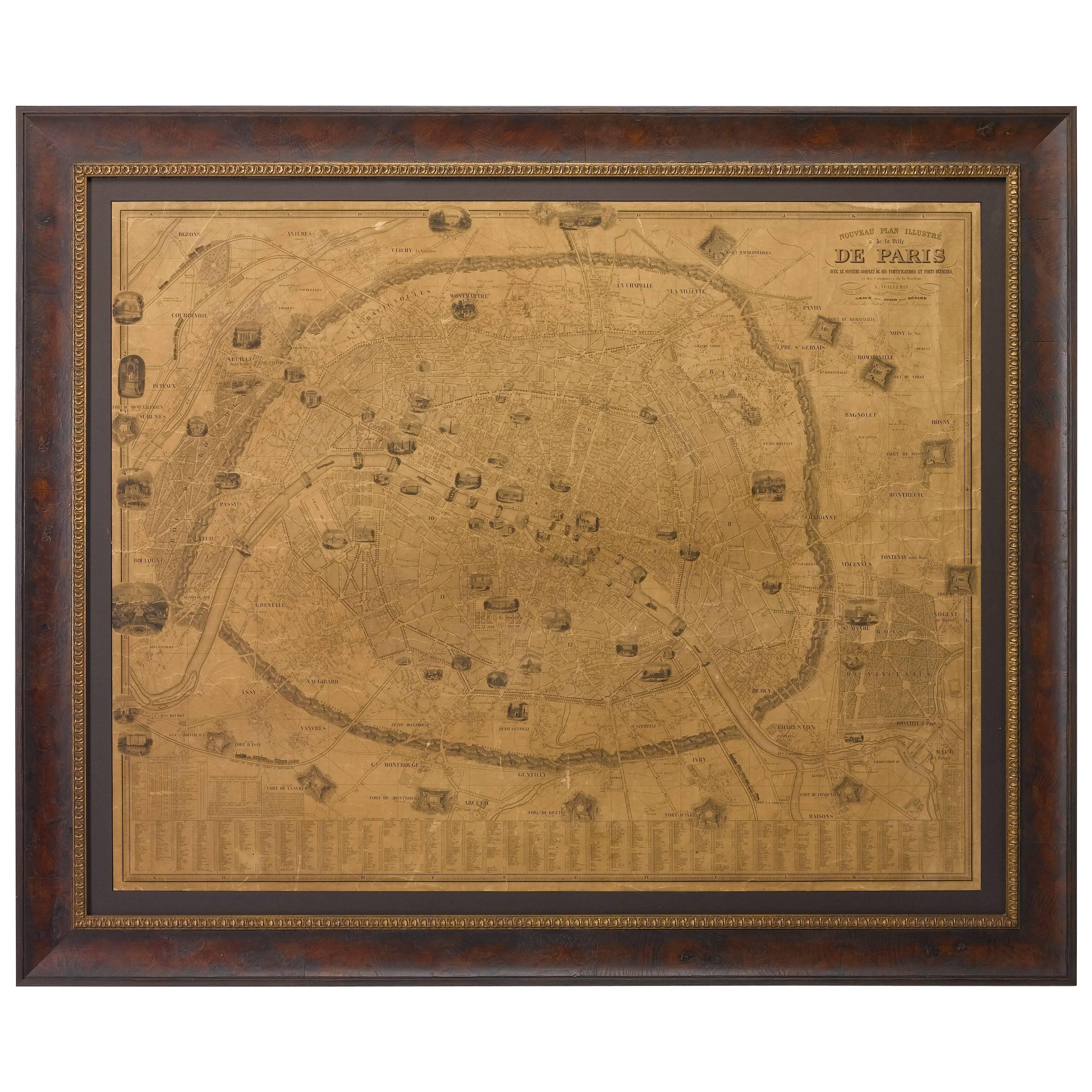
View AllPlan of Paris, France, by A. Vuillemin, Antique Map, 1845
Located in Colorado Springs, CO
This large and detailed plan of Paris was published by Alexandre Vuillemin in 1845. The map conveys a wonderful amount of information and is decorated throughout with pictorial vigne...
Category
Antique 1840s American Maps
Materials
Paper

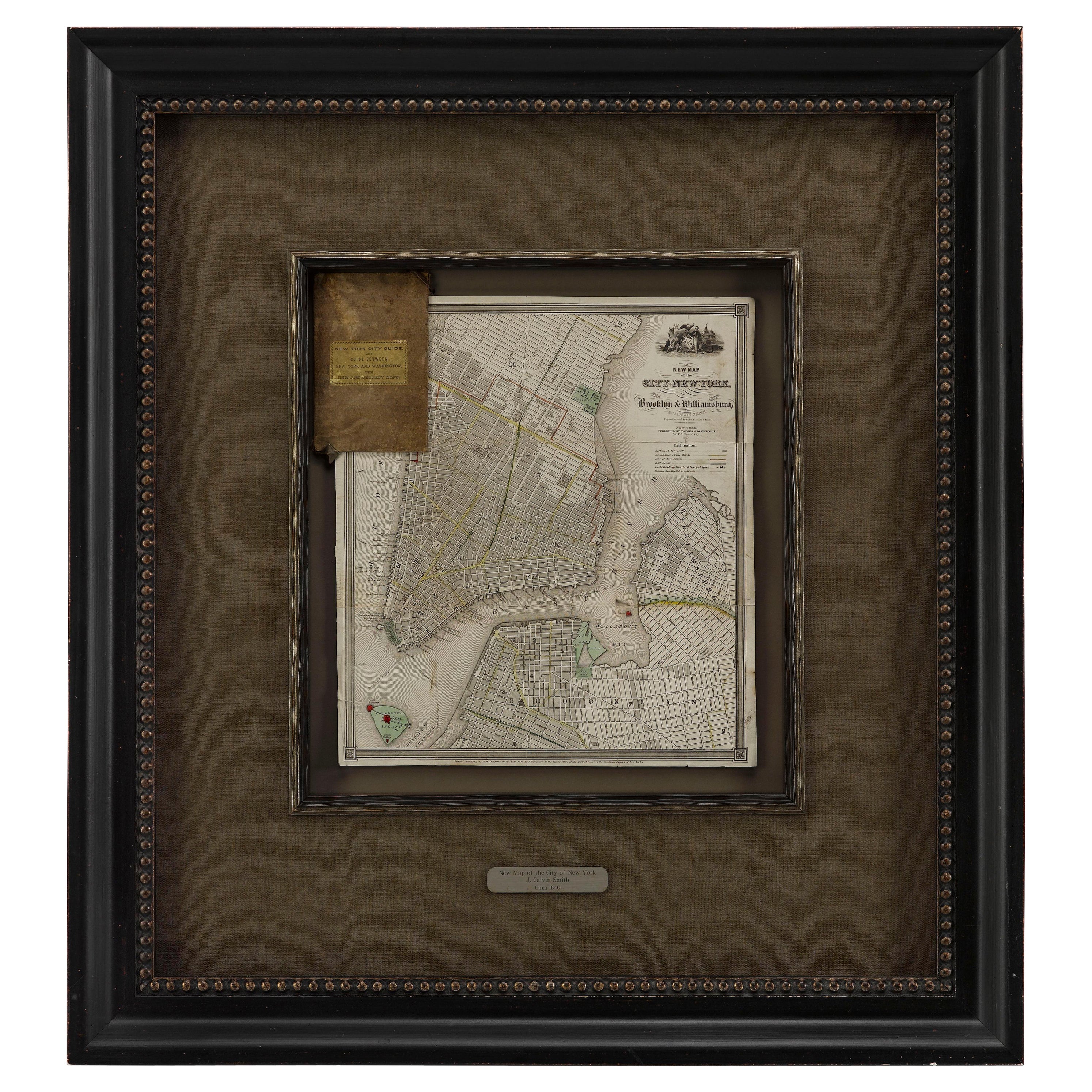
1840 "New Map of the City of New York With Part of Brooklyn & Williamsburg"
Located in Colorado Springs, CO
Presented is a hand-colored, engraved folding map titled "New Map of the City of New York With Part of Brooklyn & Williamsburg" by J. Calvin Smith. The map was issued bound in the bo...
Category
Antique 1840s American Maps
Materials
Paper

1864 Map of North America, Antique Hand-Colored Map, by Adolphe Hippolyte Dufour
Located in Colorado Springs, CO
Offered is a map of North America entitled Amerique du Nord from 1864. This rare, separately published wall map was produced by Adolphe Hippolyte Dufour. This map includes vibrant an...
Category
Antique 1860s French Maps
Materials
Paper

"The United States from the Latest Authorities" Antique Wall Map, 1835
Located in Colorado Springs, CO
This is a 1835 map of “The United States from the Latest Authorities” by Ezra Strong. A hand-colored engraved wall map of the eastern half of the United States, this map has a large inset of the "Oregon District" and several engraved city views and two portraits.
The primary map extends to Mexico Texas and the Missouri Territory, showing the course of the Missouri River to Ft. Mandan and Old Ft. Mandan, and noting many forts along the river. The territories to the east of Missouri Territory are separately delineated as Sioux District and Huron District. The western details of the map are very good for a map of this time period, with many Native American settlements, villages, forts and other details noted.
The map is bordered with vignettes of Boston, New York, Philadelphia, Hartford, Cincinnati, and Baltimore. Each vignette notes the date settled, primary settler, and the population as of 1830. Two portraits of LaFayette and George Washington are presented in full length with related biographical information.
A large inset map at lower right shows the Oregon District, centered on the Columbia River and extending to the Rocky Mountains. This is one of the earliest commercial appearances of a separate map of Oregon...
Category
Antique 1830s American Maps
Materials
Paper

1840 Map of the City of Washington Published by William M. Morrison
Located in Colorado Springs, CO
This map, printed in 1840, is a detailed representation of Washington, D.C. in the mid-19th century. The map shows block numbers, wards, and government buildings as well as details o...
Category
Antique 1840s American Federal Maps
Materials
Paper

1846 "North America" Map, Engraved by I. Dower
Located in Colorado Springs, CO
Presented is an original 1846 map of “North America.” The map was drawn and engraved by I. Dower and published in London by Orr & Company. The map depicts North America, to include G...
Category
Antique 1840s English Victorian Maps
Materials
Paper

You May Also Like
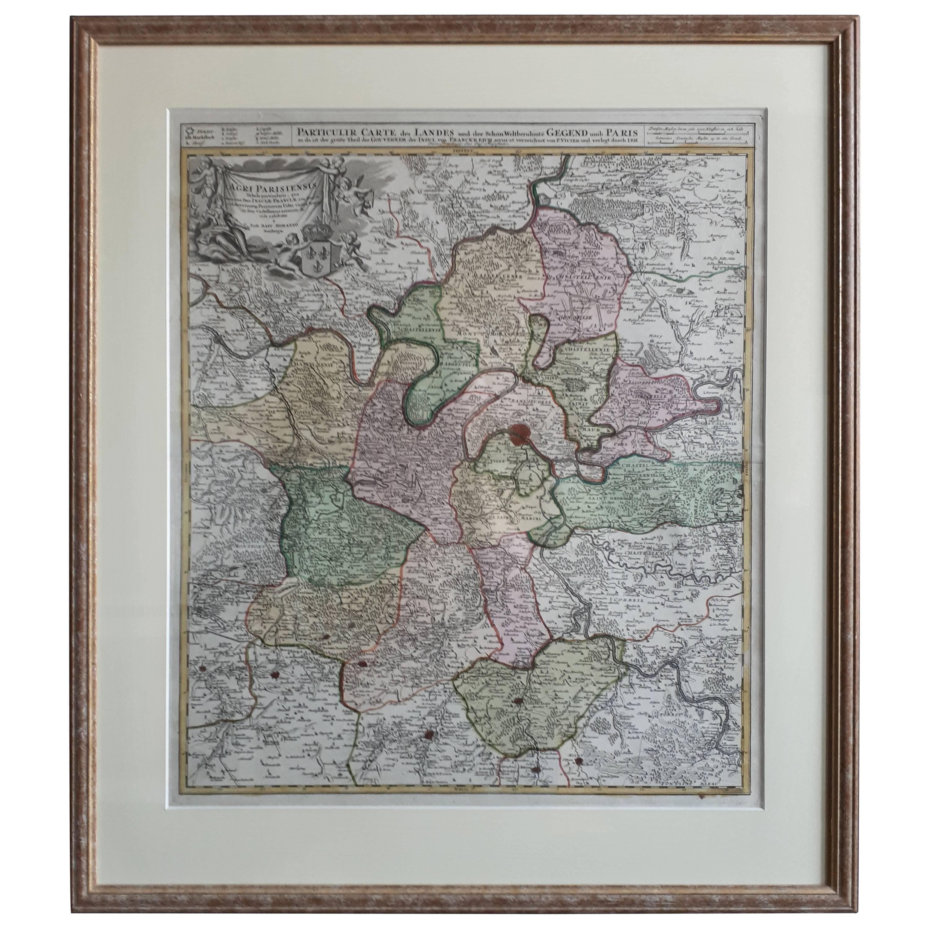
Antique Map of the Region of Paris ‘France’ by H. Heirs, circa 1720
Located in Langweer, NL
Antique map titled 'Agri Parisiensis Tabula particularis, qua maxima Pars Insulae Franciae (..)'. Incredibly detailed map showing everything from tiny villages to forests, farmland, ...
Category
Antique Early 18th Century Maps
Materials
Paper

$1,054 Sale Price
20% Off
Original Large Antique Map of Paris, France by John Dower, 1861
Located in St Annes, Lancashire
Fabulous monochrome map of Paris.
Vignettes of St Germain En Laye, Saint Cloud, Versailles and Fontainbleau.
Unframed.
Drawn by J.Dower.
Lithography by Weller. 4 sheets joined to...
Category
Antique 1860s English Victorian Maps
Materials
Paper

Antique Map of the City of Paris by Tirion '1763'
Located in Langweer, NL
Antique map titled 'Nieuwe Kaart der platte Grond van de Stad Parys (..)'. Beautiful city plan of Paris, France. This map originates from 'Nieuwe en Beknopte Hand-Atlas, bestaande in...
Category
Antique Mid-18th Century Maps
Materials
Paper

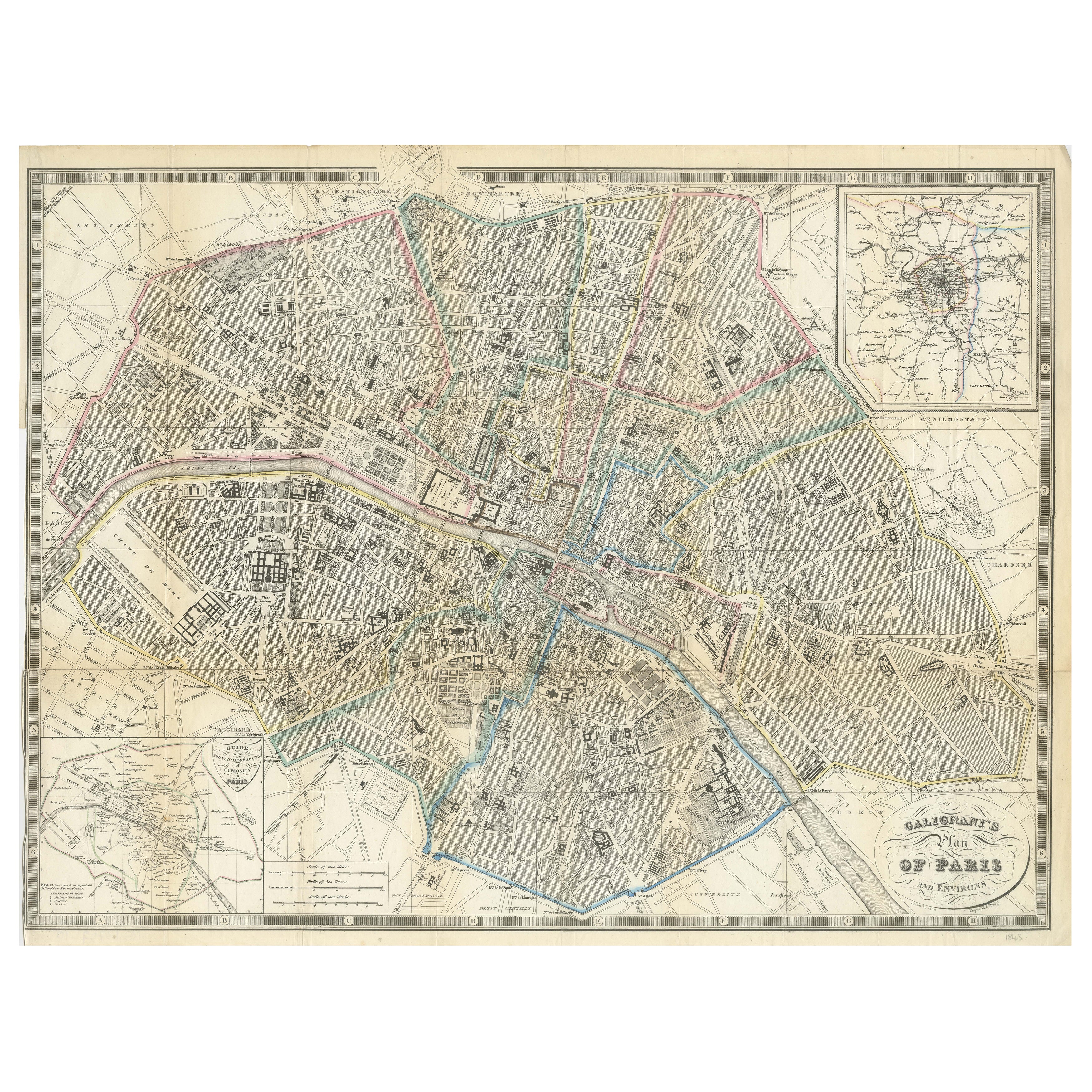
Paris and Surroundings – Antique Map by Gall and Inglis, Published 1843
Located in Langweer, NL
Antique Map of Paris and Environs by Gall and Inglis, 1843
This finely detailed map titled "Gall & Inglis’ Plan of Paris and Environs" was published in 1843 and provides a fascinati...
Category
Antique Mid-19th Century English Maps
Materials
Paper

Large Folding Map of Paris, France, on Linen, 36 Segments, Published in 1836
Located in Langweer, NL
Antique map Paris titled 'Carte Topographique des Environs de Paris Nouvelle edition rectifié d'apres les travaux de la Nouvelle Carte De France'.
...
Category
Antique 1830s Maps
Materials
Paper
$1,294 Sale Price
20% Off
Large Scale Map of the London Metropolis
Located in Dallas, TX
The product is a large scale map of the London Metropolis, specifically focusing on the city in intricate detail. It would be a valuable collectible for those interested in maps and ...
Category
Mid-20th Century English Maps
Materials
Paper
More Ways To Browse
Antique Hand Saw
French Matting
French Wall Pocket
Framed Map Of Paris
Antique Maps Of Africa
Antiques Compasses
Antique Navigation
Colonial Furniture Company
Mississippi Furniture
Antique Scottish Wood Furniture
Indonesia Map
Antique Framed Map Engravings
Atlas Furniture Company
Used Office Furniture Edinburgh
Antique 16th Century Plates
Scotland Map
Antique Maps Indonesia
Map Of Japan