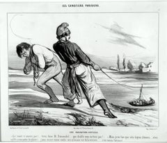
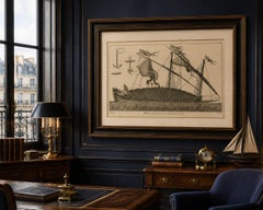
Une Navigation Difficile
By Honoré Daumier
Located in New York, NY
Translation: A DIFFICULT NAVIGATION. – The boat doesn’t move! Pull Dumouchel, pull…. why the devil don’t you pull!
Category
1840s Realist Antique Navigation
Materials
Lithograph
Une Navigation Difficile
By Honoré Daumier
Located in New York, NY
Translation: A DIFFICULT NAVIGATION. – The boat doesn’t move! Pull Dumouchel, pull…. why the devil don’t you pull!
Lithograph
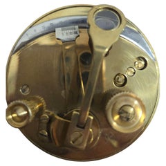
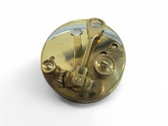
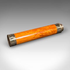
Portable Bronze Sextant for Nautical Navigation
Located in Madrid, ES
Elegant portable bronze sextant used for nautical navigation, finely crafted with precise detailing and compact design.
Bronze
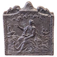
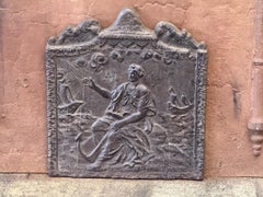
19th Century French Fireback / Backsplash 'Allegory of Navigation'
Located in Amerongen, Amerongen
19th Century French Napoleon III Period fireback with an allegory of Navigation. The fireback is made of cast iron and has a natural brown patina.
Iron
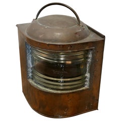
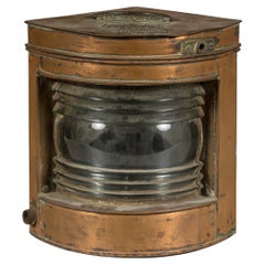
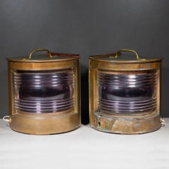
Antique Copper Navigation Light, Industrial Nautical Decor, 1900
Located in Godshill, Isle of Wight
Well Weathered Ships Copper Navigation Light. The lamp is flat sided with original bowed and ridged glass front, this has the date which it was last replaced etched on the front A g...
Copper
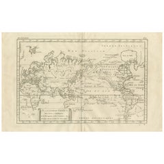
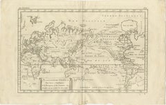
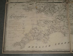
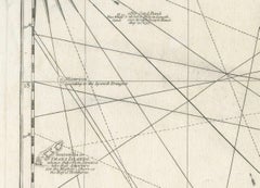
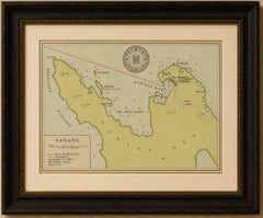
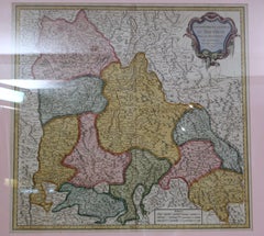
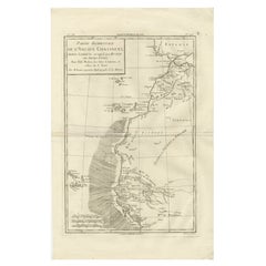
General World Planisphere for Navigation & Trade – Bonne c.1780
Located in Langweer, NL
General World Planisphere for Navigation & Trade – Bonne c.1780 DESCRIPTION This large planisphere presents a unified view of the world designed to support navigation, commerce, and...
Paper
$1,693Sale Price|20% Off
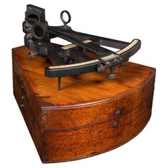
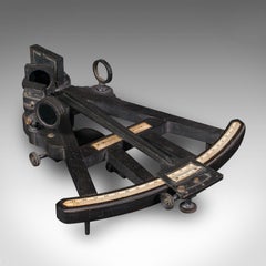
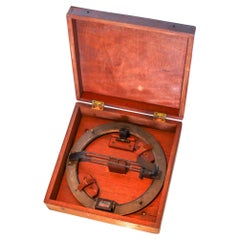
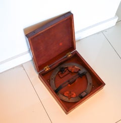
Antique Cased Octant, Scottish, Ebony, Navigation Instrument, Sextant, Victorian
Located in Hele, Devon, GB
A Scottish, ebony navigational instrument, dating to the Victorian period, circa 1850.
Ebony, Walnut
$1,680Sale Price / set|20% Off
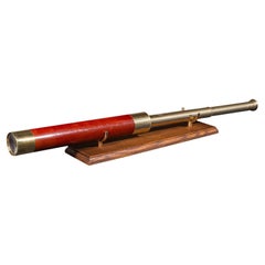
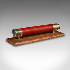
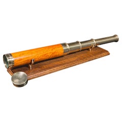
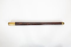
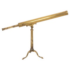
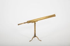
Antique 2 Draw Telescope, English, Brass, Navigational Instrument, Victorian
Located in Hele, Devon, GB
This is an antique 2-draw telescope, an English terrestrial or maritime navigational instrument, dating to the late Victorian period, circa 1900.
Brass
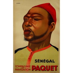
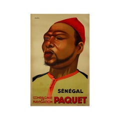
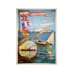
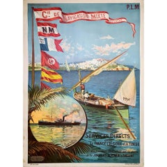
Original poster "Sénégal Compagnie de Navigation Paquet" by Viano - Africa
By Viano
Located in PARIS, FR
The original poster "Sénégal Compagnie de Navigation Paquet" by Viano, created to promote the Compagnie de Navigation Paquet, showcases the artist's ability to capture the essence of...
Linen, Paper, Lithograph
$2,279Sale Price / set|20% Off
Antique Three-Draw Telescope, English, Walnut, Brass, Navigation, Georgian, 1790
Located in Hele, Devon, GB
An English,walnut and brass navigational or astronomical instrument by Lincoln of London, dating to the Georgian period, circa 1790.
Brass
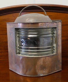
Nautical Tung Woo Starboard Ship Navigation Copper Lantern with Label
Located in Yonkers, NY
A nautical Tung Woo starboard ship navigation copper lantern from the early 20th century with label and glass.
Copper
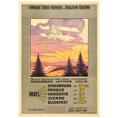
Original Antique Travel Poster Compagnie Franco Roumaine De Navigation Aerienne
Located in London, GB
Original antique travel advertising poster for the Compagnie Franco Roumaine de Navigation Aerienne / French Romanian Company for Air Transport featuring great artwork of a plane fly...
Paper
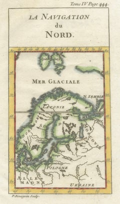

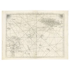
Antique Miniature Map Scandinavia & Baltic Sea, La Navigation du Nord, c.1732
Located in Langweer, NL
Antique Miniature Map of Scandinavia & Baltic Sea, La Navigation du Nord, c.1732 This finely engraved antique map titled “La Navigation du Nord” presents a compact yet informative d...
Paper

$131Sale Price|20% Off
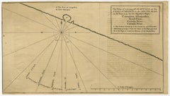
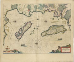
Navigational Chart of Mexico's Coast, with Acapulco and Port Marquis, 1748
Located in Langweer, NL
Antique map titled 'The Form of cruising off Acapulca on the Coast of Mexico in the South Seas in the Year 1742. by His Majesty's Ships, Centurion, Gloucester, Tryall Prize, Carmila ...
Paper
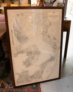
1830 DATED EXTRA LARGE 194CM X 159CM INLAND NAViGATION MAP CANALS AND RAILROADS
Located in West Sussex, Pulborough
Royal House Antiques Royal House Antiques is delighted to offer for sale this Stunning Inland Navigation map of Railroads and Canals by Nichols, Priestley & Walker dated January...
Maple
Original poster by Hugo d'Alésia for the Compagnie de Navigation mixte Touache
Located in PARIS, FR
Nice poster by Hugo d'Alésia for the Compagnie de Navigation mixte, the Touche company. The Compagnie de Navigation Mixte is an old French shipping company active from 1850 to 1981,...
Linen, Paper, Lithograph
$987Sale Price|30% Off
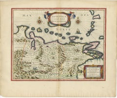
Navigational Chart of Jamaica, Cape Gracias a Dios, and the Mosquito Coast, 1775
Located in Langweer, NL
Conclusion: This map is a detailed navigational chart from the 18th century, providing valuable information about the geography and political landscape of Jamaica, Cape Gracias a Dio...
Paper
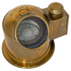
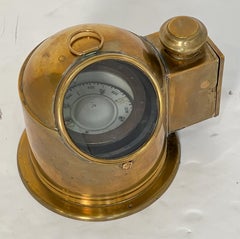
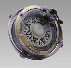
English Ship's Binnacle Compass of Brass with Side Burner Light
Located in Austin, TX
Even with modern electronic navigation, many international ships are still required to carry a standard magnetic compass, often mounted in a binnacle.
Metal, Brass
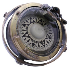
Early 20th Century Bronze and Brass Gimballed Ship's Compass by F. Smith & Sons
Located in Worcester, GB
The mounting retains its original side trunnions, indicating installation within a binnacle or similar navigational housing. The metalwork has acquired an attractive aged patina from...
Bronze
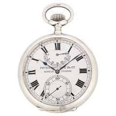
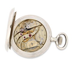
Patek Philippe Silver Deck Chronometer
By Patek Philippe
Located in New Orleans, LA
This particular chronometer's distinguished service continued when it was acquired by the US Government in 1915 for use aboard an airship of the US Navy, where such precision instrum...
Silver
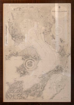
1930s Framed Antique Japanese Nautical Chart Shimabara Kaiwan
Located in Marbella, ES
The chart displays an extraordinary level of topographic and maritime detail, including soundings, coastlines, routes, and navigational references. Presented in an elegant dark wood...
Paper
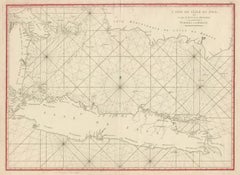
Antique Sea Chart Java Indonesia – Mannevillette Neptune Oriental 1775
Located in Langweer, NL
Mannevillette was one of the most respected navigational cartographers of the eighteenth century.
Paper
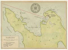
Sabang Bay & Pulau Weh – Antique Dutch Colonial Map of Sumatra, Indonesia, 1910
Located in Langweer, NL
The map is especially desirable for collectors of Indonesian colonial history, Southeast Asian cartography, maritime navigation, and Dutch East Indies material. It also holds strong ...
Paper
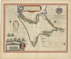
Blaeu Strait of Magellan Map – Tierra del Fuego, Decorative Sea Chart, 1642
Located in Langweer, NL
During the 17th century, this route was essential for navigation between the Atlantic and Pacific Oceans, making it a focal point for European exploration and trade.
Paper
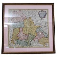
Antique Map of France Bailliages Dauphine Region South East Framed 1751
Located in Wilton, CT
Alongside his father, Gilles, he produced the Atlas Universel (1757) and was a royal censor for geography and navigation works. Interesting 18th century map with great graphics.
Paper
$665Sale Price|30% Off
AZIMUTH Circle E.S. Ritchie & Sons US Navy Maritime Compass Bronze & Wood Box
By E.S. Ritchie & Co
Located in Miami, FL
Navy supplier and a leader in navigation technology, still operating today under the name Ritchie Navigation in Pembroke, MA.
Brass, Bronze

Eyes on the Horizon: A 19th-Century Captain’s Spyglass by Dollond
Located in New York, NY
The brass barrel is engraved “Dollond London,” confirming its association with the firm founded by John Dollond, celebrated for advancements in achromatic lenses that revolutionized ...
Brass
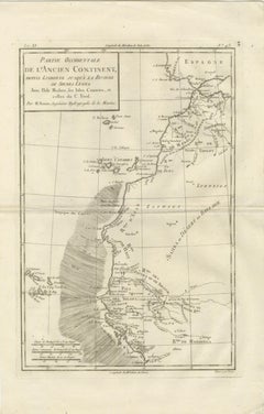
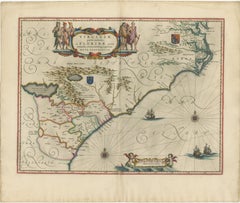
Antique Map West Africa Morocco Canary Islands Lisbon Sierra Leone Bonne, c1780
Located in Langweer, NL
The shaded ocean area suggests navigational zones or areas of maritime interest, reinforcing the map’s hydrographic purpose.
Paper

Carte des Isles Philippines – Antique Map of the Philippines, 1752
Located in Langweer, NL
Fine coastal detailing, navigational notations, and engraved place names reveal the growing European interest in the strategic and commercial importance of the archipelago during the...
Paper
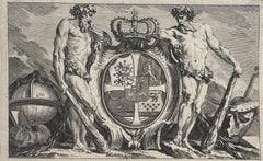
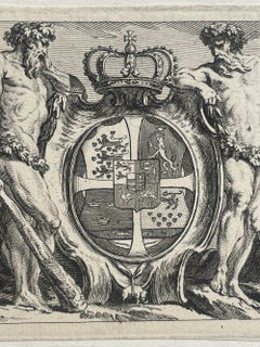
Royal Coat of Arms of Denmark with Order of the Elephant, 17th century engraving
Located in Firenze, IT
Baroque composition with allegorical figures and attributes of power and navigation, typical of official publications of the late 17th century.
Paper, Engraving
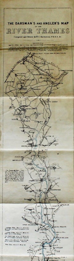
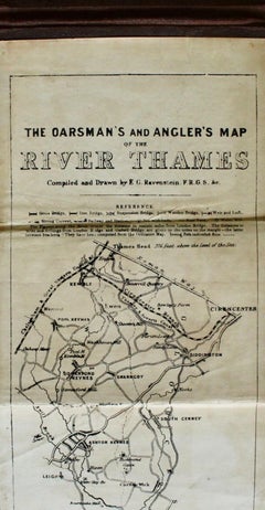
The Oarsman's and Angler's Map of the River Thames, Published by C. Smith & Son
Located in Colorado Springs, CO
The map starts at the Thames Head, in Cirencester, and ends at the London Bridge, in London. It includes navigation notes for rowers and specific locations for catching trout, ...
Fabric, Linen, Paper
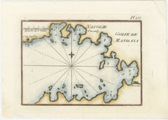
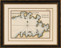
Golfe de Mandaya Sea Chart by Joseph Roux, Ottoman Turkey, c.1764
Located in Langweer, NL
Depth soundings, anchorage indications, and coastal notations provide navigational detail for mariners navigating the eastern Mediterranean during the Ottoman period.
Paper
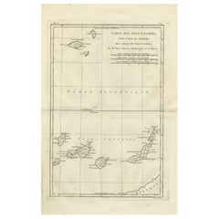
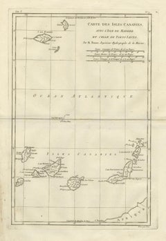
Canary Islands & Madeira Map – Atlantic Archipelagos c.1780
Located in Langweer, NL
KEYWORDS Canary Islands map, Madeira Porto Santo, Atlantic navigation, transatlantic routes, island cartography CONDITION REPORT Light age toning.
Paper

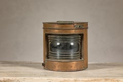
Antique English Copper and Brass Ship Lanterns-Pair
Located in San Francisco, CA
ABOUT A pair of beautifully patinated, molded copper antique nautical ship lanterns, specifically designed as navigation lights. These types of lanterns were historically essentia...
Brass, Copper
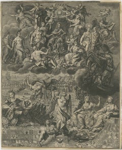
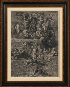
Allegory on the Reign of Habsburg Emperor Charles VI, Holy Roman Emperor, c.1720
Located in Langweer, NL
Particularly fascinating are the numerous details revealed upon close examination: cherubs carrying imperial regalia, military encampments, heraldic banners, symbols of trade and nav...
Paper
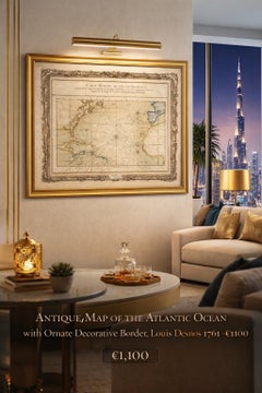

Antique Map of the Atlantic Ocean by Desnos with Ornate Border, 1761
Located in Langweer, NL
These navigational elements, combined with carefully engraved coastlines and place names, highlight the practical function of the map while also contributing to its strong visual rhy...
Paper
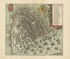

Antique Map of Amsterdam, Bird's-Eye City Plan from Guicciardini, c.1610
Located in Langweer, NL
The bustling waterfront along the IJ is crowded with sailing vessels, merchant ships, and smaller craft, vividly illustrating the city's intimate connection with international trade ...
Paper
19th-Century French Maritime Telescope by Biette à Lyon
Located in New York, NY
Originally intended for navigation, coastal surveying, and long-distance observation aboard ship, the telescope remains an evocative object of maritime history.
Brass
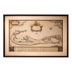
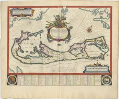
Blaeu Bermuda Map, Somers Isles, Atlantic Chart, Hand-Colored, c.1642
Located in Langweer, NL
Additional decorative elements include finely engraved compass roses, coats of arms, and navigational rhumb lines, all enhanced by later hand coloring that brings clarity and warmth ...
Paper
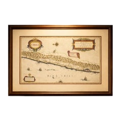
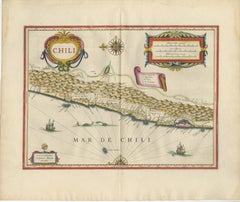
Antique Chile Map Blaeu c.1642 – Dramatic Andes & Pacific Panorama
Located in Langweer, NL
The Pacific Ocean is animated with sailing ships and navigational lines, emphasizing the maritime importance of the region during the age of exploration and global trade.
Paper
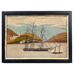

British Sailor's Woolwork of Royal Navy Ships in a Bay
Located in Downingtown, PA
The inclusion of a detailed lighthouse further underscores the sailor's profound connection to the sea and the essential navigational markers that guided their journeys.
Wool
Blaeu Map of Île de Ré & Oléron, La Rochelle Coast France, c.1642
Located in Langweer, NL
Blaeu’s coastal maps are especially prized for their combination of navigational detail and decorative elegance. This example, focusing on one of France’s most historically significa...
Paper
Blaeu Virginia and Florida Map – Decorative Early America Chart, 1642
Located in Langweer, NL
The coastline is crisply delineated, reflecting European navigation and colonial interest in the region, while inland areas are rendered with pictorial mountain ranges, rivers, and s...
Paper
Blaeu Venezuela Map – Decorative Caribbean & Nueva Andalusia Chart 1642
Located in Langweer, NL
Two finely engraved compass roses radiate across the sea, intersected by rhumb lines that create a sense of movement and navigation. A sailing vessel animates the waters, reinforcing...
Paper
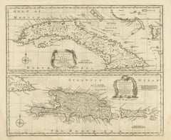
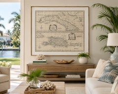
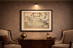
Antique Map of Cuba & Hispaniola, Caribbean Sea Chart by Bowen, 1744
Located in Langweer, NL
Coastal towns, anchorages, banks, shoals, and maritime passages are carefully identified, illustrating the navigational focus of the chart. The lower section centers on Hispaniola an...
Paper
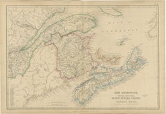
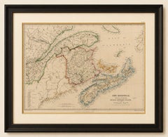
Antique Map of New Brunswick, Nova Scotia, Prince Edward Island and Canada East
Located in Langweer, NL
Numerous harbors, fishing settlements, and navigational landmarks reflect the importance of maritime trade, shipbuilding, fishing, and transatlantic commerce to the region's economy.
Paper
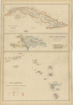
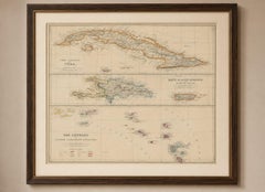
Antique Map of Cuba, Hispaniola, Puerto Rico and the Leeward Islands, 1860
Located in Langweer, NL
The map reflects this importance through its careful depiction of ports, anchorages, settlements, and navigational landmarks. Original hand coloring highlights the colonial division...
Paper
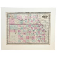

1870 "Johnson's Kansas and Nebraska" Antique Map Published by A. J. Johnson
Located in Colorado Springs, CO
Guyot further demonstrates that period’s growing interest in scientific inquiry, making the atlas a valuable resource not just for navigation and geography, but also for understandin...
Paper
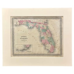
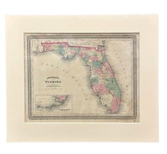
1870 "Johnson's Florida" Antique Map Published by A. J. Johnson
Located in Colorado Springs, CO
Guyot further demonstrates that period’s growing interest in scientific inquiry, making the atlas a valuable resource not just for navigation and geography, but also for understandin...
Paper
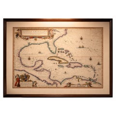
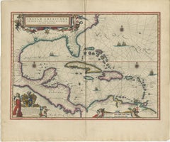
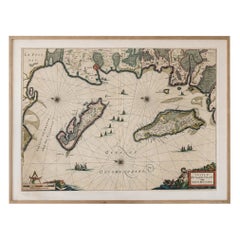
Important Blaeu Caribbean Map, West Indies, Decorative Atlas Chart, c.1642
Located in Langweer, NL
The surrounding seas are richly structured with rhumb lines, compass roses, and sailing vessels, emphasizing the region’s central role in early transatlantic navigation and trade. B...
Paper
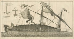
La Réale French Royal Galley, Large Naval Engraving, c.1769
Located in Langweer, NL
The image was drawn by Jacques Nicolas Bellin, one of the most important hydrographers of the 18th century, whose work shaped European understanding of naval architecture and global ...
Paper
Black Rock New York Harbor Lighthouse – Antique Steel Engraving c.1850
Located in Langweer, NL
The composition shows the powerful meeting of water, wind, and navigation along the shores of Lake Erie and the Niagara River.
Paper
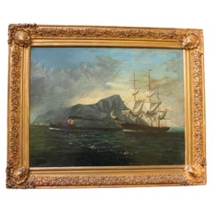
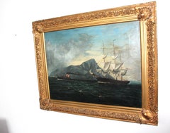
20th Century Marine Oil Painting of Ships off the Coast of Gibraltar
Located in Seaford, GB
The composition captures a moment of transition in seafaring history, where traditional sail navigation intersects with the growing dominance of steam assistance.
Canvas
Antique Caribbean Map, Jamaica Cuba Saint-Domingue, Tardieu, c.1775
Located in Langweer, NL
Jamaica, then under British control, is shown in remarkable detail, while Cuba stretches across the upper left portion of the composition with numerous coastal place names and naviga...
Paper
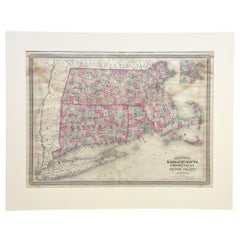
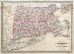
1870 "Johnson's Massachusetts, Connecticut and Rhode Island" Antique Map
Located in Colorado Springs, CO
Guyot further demonstrates that period’s growing interest in scientific inquiry, making the atlas a valuable resource not just for navigation and geography, but also for understandin...
Paper
Rare French Colonial America Map, Jamaica Barbados Carolina, c.1719
Located in Langweer, NL
The extensive French text surrounding the maps discusses colonial resources, trade routes, sugar production, agriculture, navigation, population, and strategic importance. Such infor...
Paper
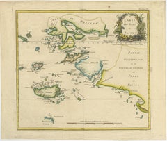
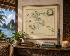
Antique Map of Raja Ampat and New Guinea, Bellin, Papuan Islands c.1749
Located in Langweer, NL
Bellin’s rendering captures the fragmented geography of this maritime landscape with remarkable clarity, depicting narrow straits, scattered islets, and navigational routes that woul...
Paper
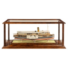
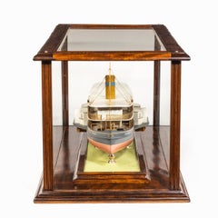
Builder’s Model of the Brazilian Passenger Paddle Steamer Caxias
Located in Lymington, Hampshire
A builder’s model of the Brazilian passenger paddle steamer Caxias built by Hepple, South Shields, 1912, with a 24in. laminated and carved hull finished in pink below the waterline w...
Laminate, Wood, Mahogany