Items Similar to Antique Map of the Region of Algiers, Algeria

Want more images or videos?
Request additional images or videos from the seller
1 of 6
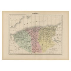
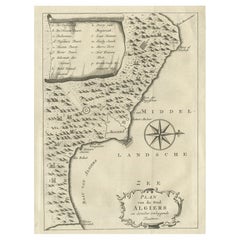
Antique Map of the Region of Algiers, Algeria
$162.95
$203.6820% Off
£121.28
£151.6020% Off
€136
€17020% Off
CA$223.20
CA$27920% Off
A$248.24
A$310.3120% Off
CHF 129.63
CHF 162.0320% Off
MX$3,020.87
MX$3,776.0820% Off
NOK 1,655.51
NOK 2,069.3920% Off
SEK 1,552.58
SEK 1,940.7320% Off
DKK 1,035.32
DKK 1,294.1520% Off
Shipping
Retrieving quote...The 1stDibs Promise:
Authenticity Guarantee,
Money-Back Guarantee,
24-Hour Cancellation
About the Item
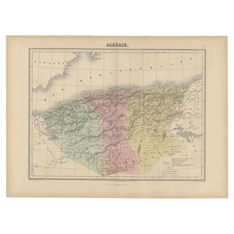
Antique map titled 'Alger'. This map shows the region of Algiers, Algeria. With a small inset map of the region of Algiers and a decorative vignette with a harbor view. Originates from 'Dictionnaire Universel de Geographie (.)'. Published by Binet, circa 1842.
- Dimensions:Height: 10.01 in (25.4 cm)Width: 12.05 in (30.6 cm)Depth: 0.02 in (0.5 mm)
- Materials and Techniques:
- Period:
- Date of Manufacture:circa 1842
- Condition:General age-related toning, minor wear and soiling. Few very tiny defects/weak spots. Blank verso. Please study image carefully.
- Seller Location:Langweer, NL
- Reference Number:Seller: BG-13379-21stDibs: LU3054333197362
About the Seller
5.0
Recognized Seller
These prestigious sellers are industry leaders and represent the highest echelon for item quality and design.
Platinum Seller
Premium sellers with a 4.7+ rating and 24-hour response times
Established in 2009
1stDibs seller since 2017
2,508 sales on 1stDibs
Typical response time: <1 hour
- ShippingRetrieving quote...Shipping from: Langweer, Netherlands
- Return Policy
Authenticity Guarantee
In the unlikely event there’s an issue with an item’s authenticity, contact us within 1 year for a full refund. DetailsMoney-Back Guarantee
If your item is not as described, is damaged in transit, or does not arrive, contact us within 7 days for a full refund. Details24-Hour Cancellation
You have a 24-hour grace period in which to reconsider your purchase, with no questions asked.Vetted Professional Sellers
Our world-class sellers must adhere to strict standards for service and quality, maintaining the integrity of our listings.Price-Match Guarantee
If you find that a seller listed the same item for a lower price elsewhere, we’ll match it.Trusted Global Delivery
Our best-in-class carrier network provides specialized shipping options worldwide, including custom delivery.More From This Seller
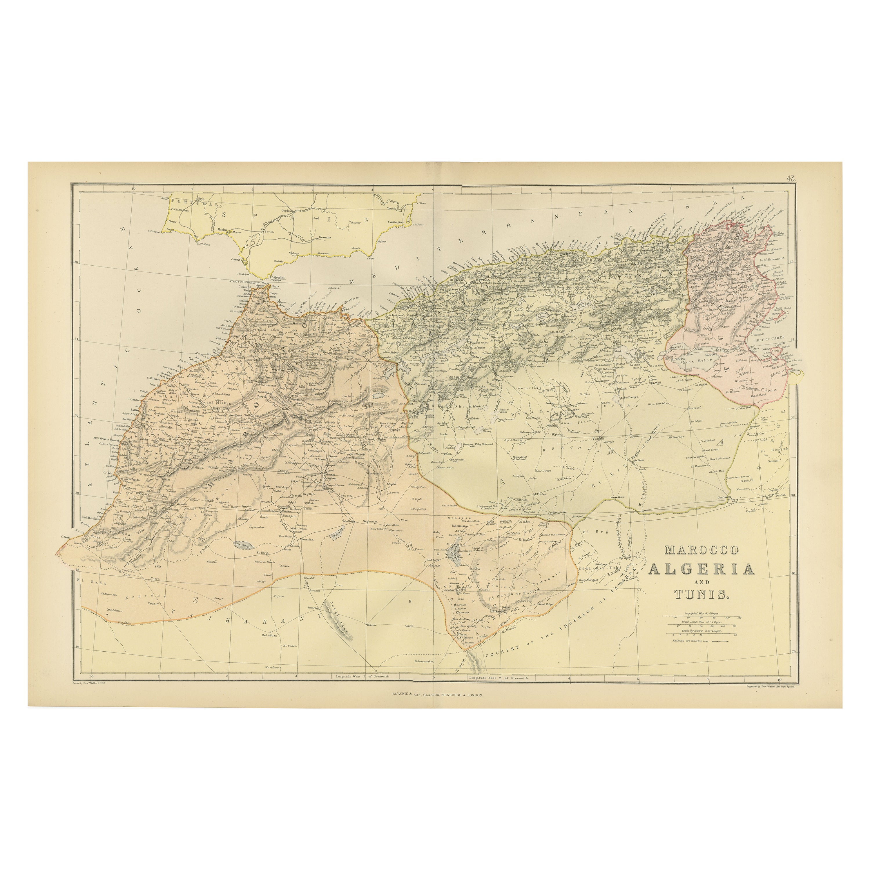
View AllAntique Decorative Coloured Map Marocco, Algeria and Tunis, 1882
Located in Langweer, NL
The maps is from the 1882 atlas by Blackie & Son and offers a detailed view of the North African regions as understood in the late 19th century.
**Map of Morocco, Algeria, and Tun...
Category
Antique 1880s Maps
Materials
Paper

Antique Map of Algeria, 1880
Located in Langweer, NL
Antique map titled 'Algérie. Old map of Algeria. This map originates from 'Géographie Universelle Atlas-Migeon' by J. Migeon.
Artists and Engravers: Published by J. Migeon. Review...
Category
Antique 19th Century Maps
Materials
Paper
$210 Sale Price
20% Off
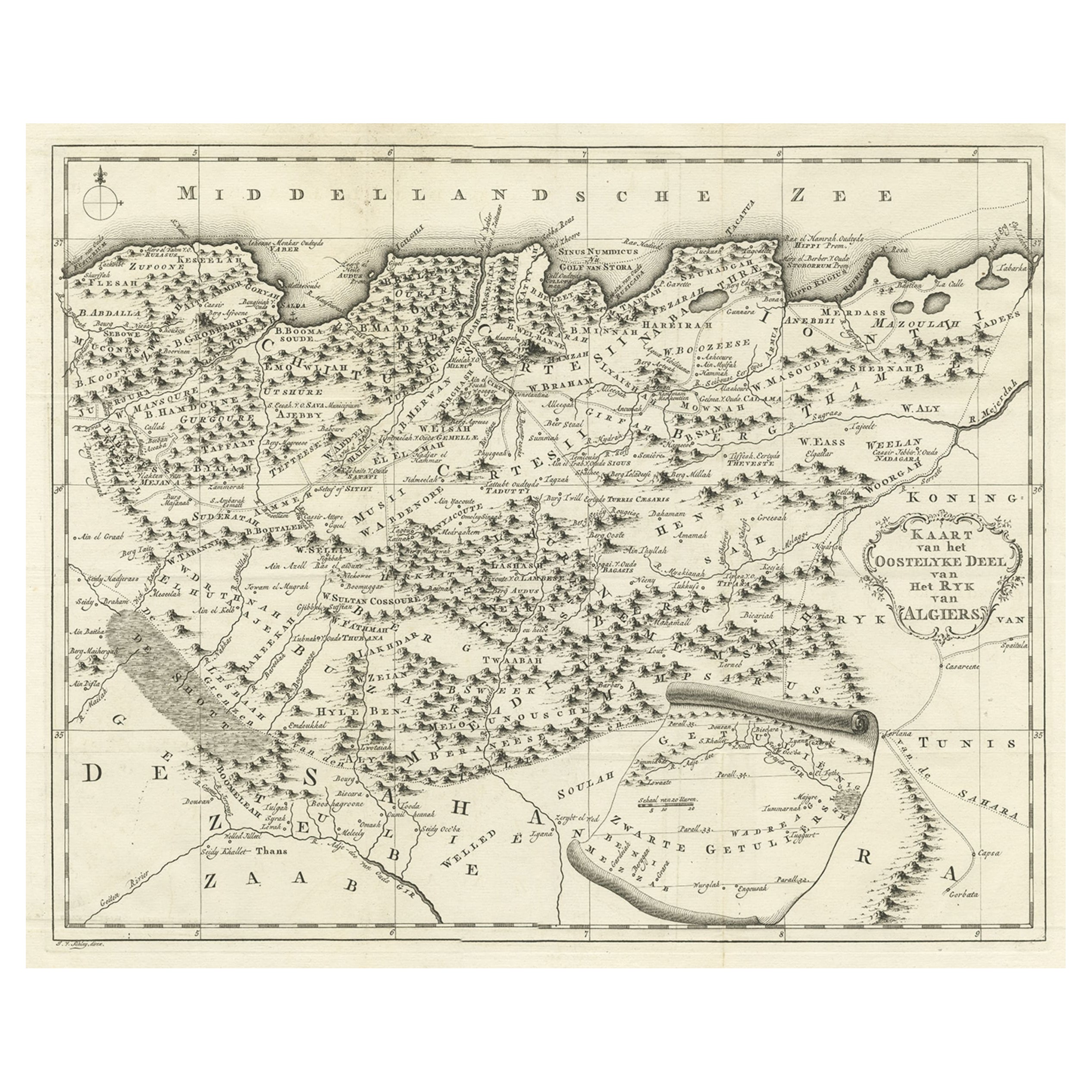
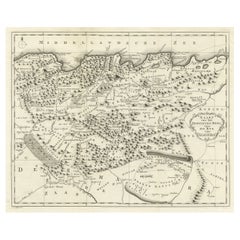
Old Map of the Eastern Region of the Kingdom of Algiers, Algeria, 1773
Located in Langweer, NL
Antique map titled 'Kaart van het Oostelyke Deel van het Ryk van Algiers'.
Old map of the eastern region of the Kingdom of Algiers, Algeria. Originates from the first Dutch edito...
Category
Antique 1770s Maps
Materials
Paper
$440 Sale Price
20% Off
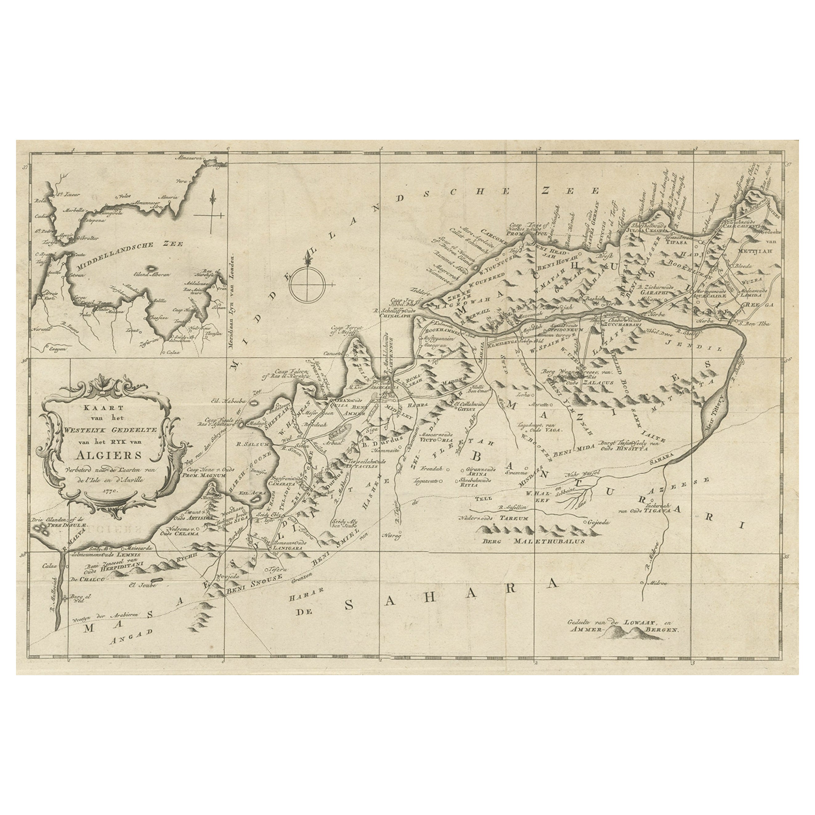
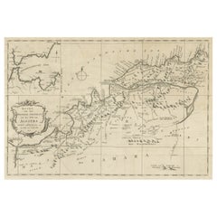
Old Map of the Western Region of the Kingdom of Algiers, Algeria, 1773
Located in Langweer, NL
Antique map titled 'Kaart van het Westelyk Gedeelte van het Ryk van Algiers'.
Old map of the western region of the Kingdom of Algiers, Algeria. Originates from the first Dutch ed...
Category
Antique 1770s Maps
Materials
Paper
$364 Sale Price
20% Off
Antique Map of the French Colony of Algeria by V. Levasseur, 1854
By Victor Levasseur
Located in Langweer, NL
Antique map titled 'Algérie, Colonie Francaise'. Shows the region divided into the administrative provinces of Oban, Alger, and Constantine. The map proper is surrounded by elaborate...
Category
Antique Mid-19th Century Maps
Materials
Paper

$191 Sale Price
20% Off
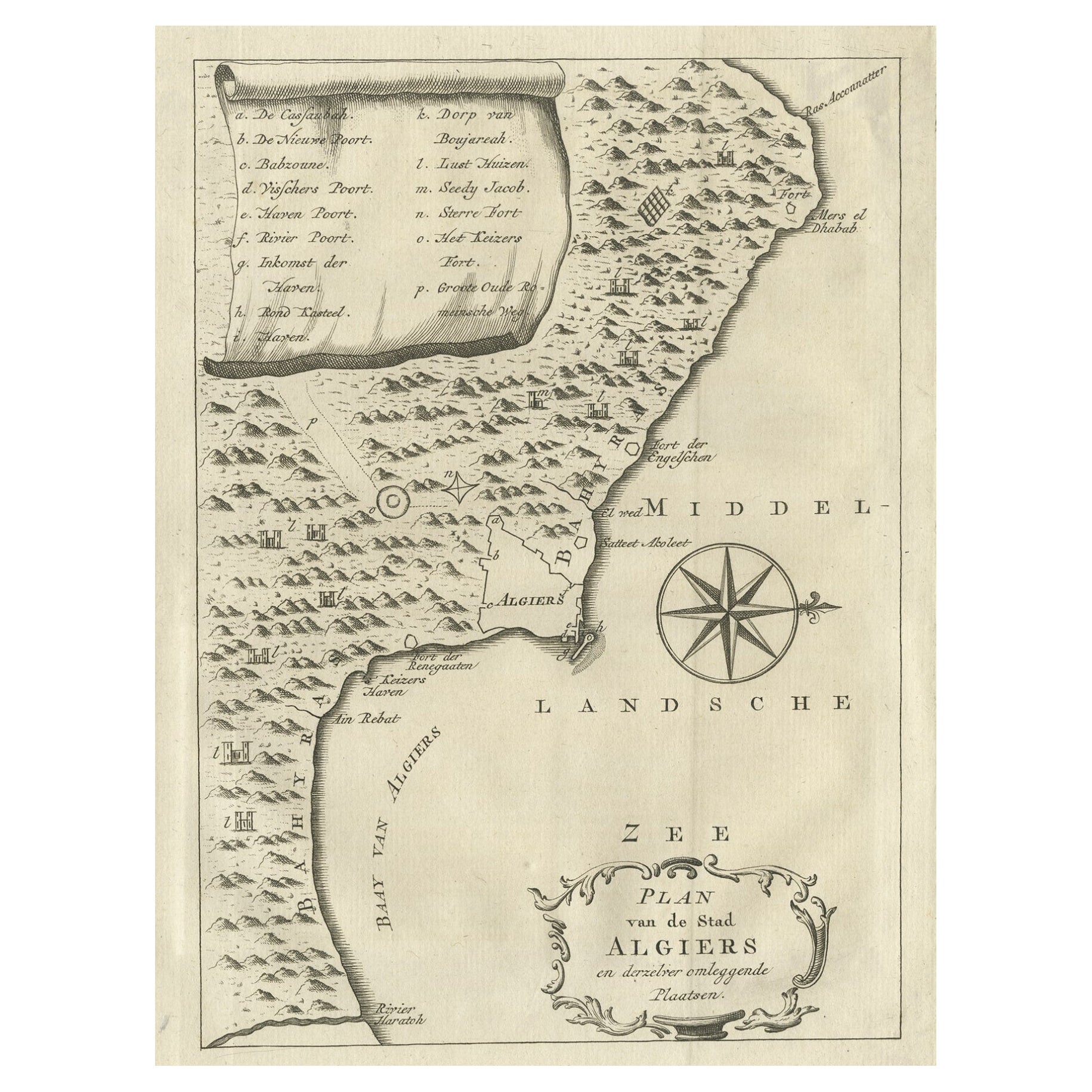
Old Map of Algiers, with Surrounding Cities and the Bay of Algiers, 1773
Located in Langweer, NL
Antique print titled 'Plan van de Stad Algiers'.
Old map of Algiers, also depicting surrounding cities and the Bay of Algiers. Originates from the first Dutch editon of an interest...
Category
Antique 1770s Maps
Materials
Paper
$345 Sale Price
20% Off
You May Also Like
Large Original Antique Map of Morocco. Edward Weller, 1861
Located in St Annes, Lancashire
Great map of Morocco
Lithograph engraving by Edward Weller
Original colour
Published, 1861
Unframed
Good condition.
Category
Antique 1860s English Victorian Maps
Materials
Paper

Large Original Antique Map of Afghanistan. Edward Weller, 1861
Located in St Annes, Lancashire
Great map of Afghanistan
Lithograph engraving by Edward Weller
Original colour
Published, 1861
Unframed
Good condition
Category
Antique 1860s English Victorian Maps
Materials
Paper

Original Antique Map of Ancient Greece, Achaia, Corinth, 1786
Located in St Annes, Lancashire
Great map of Ancient Greece. Showing the region of Thessaly, including Mount Olympus
Drawn by J.D. Barbie Du Bocage
Copper plate engraving by P.F Tardieu
Original hand color...
Category
Antique 1780s French Other Maps
Materials
Paper

Circa 1825 original engraving of the map of Syria by Giraldon Bovinet
Located in PARIS, FR
The circa 1825 original engraving of "Syrie" by Giraldon Bovinet, based on the work of L. Vivien, is a historically significant map that reflects early 19th-century cartographic tech...
Category
1820s Prints and Multiples
Materials
Engraving, Paper

Map of the Holy Land "Carte de la Syrie et de l'Egypte" by Pierre M. Lapie
By Pierre M. Lapie
Located in Alamo, CA
An early 19th century map of ancient Syria and Egypt entitled "Carte de la Syrie et de l'Egypte anciennes/dressée par M. Lapie, Colonel d'Etat Major, et...
Category
Antique Early 19th Century French Maps
Materials
Paper

Geographical Antique Map of Principality of Monaco
By Bruno Santini
Located in Alessandria, Piemonte
ST/609 - Interesting antique color map of Monaco Principality in French language : "Carte qui contient le Principauté de Piémont, le Monferrat et la comté de...
Category
Antique Late 18th Century Italian Other Maps
Materials
Paper
