Items Similar to Antique Map of the Region of Lyonnais by Nolin, 1697


Want more images or videos?
Request additional images or videos from the seller
1 of 5
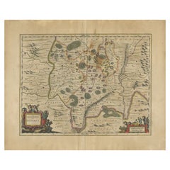
Antique Map of the Region of Lyonnais by Nolin, 1697
$227.17
$283.9620% Off
£169.08
£211.3520% Off
€189.60
€23720% Off
CA$311.16
CA$388.9520% Off
A$346.08
A$432.6020% Off
CHF 180.71
CHF 225.8920% Off
MX$4,211.45
MX$5,264.3120% Off
NOK 2,307.98
NOK 2,884.9820% Off
SEK 2,164.48
SEK 2,705.6020% Off
DKK 1,443.36
DKK 1,804.2020% Off
Shipping
Retrieving quote...The 1stDibs Promise:
Authenticity Guarantee,
Money-Back Guarantee,
24-Hour Cancellation
About the Item
Untitled map of the French Province of Lyonnais, with its capital at Lyon, on the upper Loire and Rhone rivers. This map is a single sheet and part of a two sheet map titled 'The General and Military Government of Lyons comprising the provinces of Lyons'.
Artists and Engravers: Jean-Baptiste Nolin (c.1657–1708) was a French cartographer and engraver.
Condition: Good, original/contemporary hand coloring. Minor wear, blank back. Please study image carefully.
Dated: 1697
Overall size: 76 x 54cm.
Picture size: 61.5 x 39cm.
We sell original antique maps to collectors, historians, educators and interior decorators all over the world. Our collection includes a wide range of authentic antique maps from the 16th to the 20th centuries. Buying and collecting antique maps is a tradition that goes back hundreds of years. Antique maps have proved a richly rewarding investment over the past decade, thanks to a growing appreciation of their unique historical appeal. Today the decorative qualities of antique maps are widely recognized by interior designers who appreciate their beauty and design flexibility. Depending on the individual map, presentation, and context, a rare or antique map can be modern, traditional, abstract, figurative, serious or whimsical. We offer a wide range of authentic antique maps for any budget.
- Dimensions:Height: 21.26 in (54 cm)Width: 29.93 in (76 cm)Depth: 0 in (0.01 mm)
- Materials and Techniques:
- Period:
- Date of Manufacture:1697
- Condition:
- Seller Location:Langweer, NL
- Reference Number:Seller: BG-12390-171stDibs: LU3054327830642
About the Seller
5.0
Recognized Seller
These prestigious sellers are industry leaders and represent the highest echelon for item quality and design.
Platinum Seller
Premium sellers with a 4.7+ rating and 24-hour response times
Established in 2009
1stDibs seller since 2017
2,508 sales on 1stDibs
Typical response time: <1 hour
- ShippingRetrieving quote...Shipping from: Langweer, Netherlands
- Return Policy
Authenticity Guarantee
In the unlikely event there’s an issue with an item’s authenticity, contact us within 1 year for a full refund. DetailsMoney-Back Guarantee
If your item is not as described, is damaged in transit, or does not arrive, contact us within 7 days for a full refund. Details24-Hour Cancellation
You have a 24-hour grace period in which to reconsider your purchase, with no questions asked.Vetted Professional Sellers
Our world-class sellers must adhere to strict standards for service and quality, maintaining the integrity of our listings.Price-Match Guarantee
If you find that a seller listed the same item for a lower price elsewhere, we’ll match it.Trusted Global Delivery
Our best-in-class carrier network provides specialized shipping options worldwide, including custom delivery.More From This Seller
View AllAntique Map of the Lorraine Region, c.1760
Located in Langweer, NL
Untitled antique map of the Lorraine region, France. A cultural and historical region in north-eastern France, now located in the administrative region of Grand Est. Lorraine's name ...
Category
Antique 18th Century Maps
Materials
Paper

$210 Sale Price
20% Off
Antique Map of the Limoges Region in France, c.1690
Located in Langweer, NL
Antique map titled 'Le Diocèse de Limoges'. Large map of the Limoges region, France.
The map is dedicated to the bishop of Limoges, Antoine de Charpin.
Artists and Engravers:...
Category
Antique 17th Century Maps
Materials
Paper

$623 Sale Price
20% Off
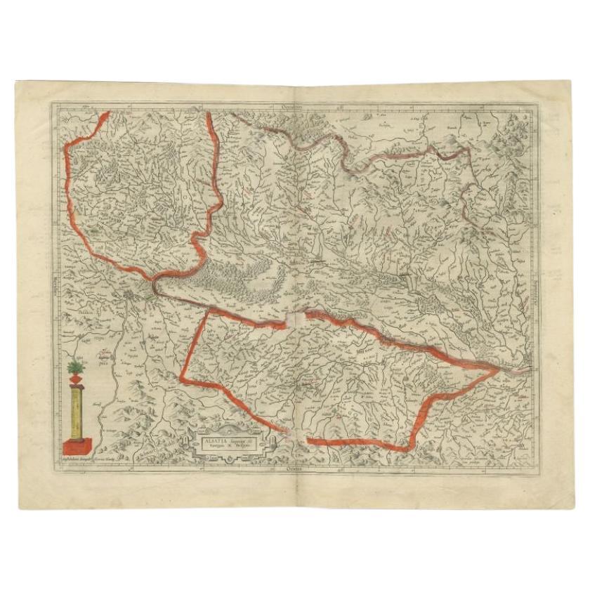
Antique Map of the Alsace Region of France by Hondius, c.1630
Located in Langweer, NL
Antique map titled 'Alsatia Superior (..)'. Original antique map of the Alsace (Elzas) region of France. The map is centered on the course of the Rhine River, from Strasbourg in the north to Basle. Artists and Engravers: Published by H. Hondius. Henricus Hondius...
Category
Antique 17th Century Maps
Materials
Paper
$243 Sale Price
20% Off
Antique Map of the Region of Namur by De Lat, 1737
Located in Langweer, NL
Untitled map of the region of Namur, Charlemont, Rochefort and surroundings, Belgium. This map originates from 'Nieuw en beknopt Kaart-Boekje vertoonende de XVII. Nederlandse Provint...
Category
Antique 18th Century Maps
Materials
Paper
$122 Sale Price
20% Off
Antique Map of the Lorraine Region 'France' (c.1735)
Located in Langweer, NL
Antique map titled 'Carte du Duche de Lorraine - Kaart van Lotharingen'. A detailed map of the Duchy of Lorraine. The map is surrounded by thirteen vignette bird-eye view of fortifie...
Category
Antique Mid-18th Century Maps
Materials
Paper

$263 Sale Price
20% Off
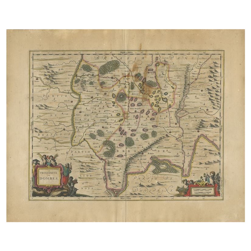
Antique Map of the Region of Lyon by Janssonius, 1657
By Johannes Janssonius
Located in Langweer, NL
Antique map of France titled 'La Principaute de Dombes'. Detailed map of the area above Lyon. This map originates from 'Atlas Novus, Sive Theatrum Orbis Orbis Terrarum: In quo Gallia...
Category
Antique 17th Century Maps
Materials
Paper
$395 Sale Price
20% Off
You May Also Like
1771 Bonne Map of Poitou, Touraine and Anjou, France, Ric.a015
Located in Norton, MA
1771 Bonne Map of Poitou,
Touraine and Anjou, France
Ric.a015
1771 Bonne map of Potiou, Touraine and Anjou entitled "Carte des Gouvernements D'Anjou et du Saumurois, de la Touraine, du Poitou,du Pays d'aunis, Saintonge?Angoumois,"
Carte des gouvernements d'Anjou et du Saumurois, de la Touraine, du Poitou, du Pays d'Aunis, Saintonge-Angoumois. Projettee et assujettie au ciel par M. Bonne, Hyd. du Roi. A Paris, Chez Lattre, rue St. Jacques a la Ville de Bord(ea)ux. Avec priv. du Roi. 1771. Arrivet inv. & sculp., Atlas moderne ou collection de cartes sur toutes...
Category
Antique 17th Century Unknown Maps
Materials
Paper

1640 Joan Bleau Map Entitled"Diocecese de rheims et le pais de rethel, " Eic.a011
Located in Norton, MA
1640 Joan Bleau map entitled
"Diocecese de rheims et le pais de rethel,"
Ric.a011
OAN BLAEU
Diocecese de Rheims, et le pais de Rethel.
Handcolored engraving, c.1640.
...
Category
Antique 17th Century Dutch Maps
Materials
Paper

Original Antique Map of Switzerland, Engraved By Barlow, Dated 1807
Located in St Annes, Lancashire
Great map of Switzerland
Copper-plate engraving by Barlow
Published by Brightly & Kinnersly, Bungay, Suffolk.
Dated 1807
Unframed.
Category
Antique Early 1800s English Maps
Materials
Paper

1752 Vaugoundy Map of Flanders : Belgium, France, and the Netherlands, Ric.a002
Located in Norton, MA
Large Vaugoundy Map of Flanders:
Belgium, France, and the Netherlands
Colored -1752
Ric.a002
Description: This is a 1752 Didier Robert de Vaugondy map of Flanders. The map de...
Category
Antique 17th Century Unknown Maps
Materials
Paper

1657 Janssonius Map of Vermandois and Cappelle, Ric. A-004
Located in Norton, MA
1657 Janssonius map of
Vermandois and Cappelle
Ric.a004
Description: Antique map of France titled 'Descriptio Veromanduorum - Gouvernement de la Cappelle'. Two detailed maps o...
Category
Antique 17th Century Unknown Maps
Materials
Paper

17th Century Hand Colored Map of the Liege Region in Belgium by Visscher
By Nicolaes Visscher II
Located in Alamo, CA
An original 17th century map entitled "Leodiensis Episcopatus in omnes Subjacentes Provincias distincté divisusVisscher, Leodiensis Episcopatus" by Nicolaes Visscher II, published in Amsterdam in 1688. The map is centered on Liege, Belgium, includes the area between Antwerp, Turnhout, Roermond, Cologne, Trier and Dinant.
This attractive map is presented in a cream-colored mat measuring 30" wide x 27.5" high. There is a central fold, as issued. There is minimal spotting in the upper margin and a tiny spot in the right lower margin, which are under the mat. The map is otherwise in excellent condition.
The Visscher family were one of the great cartographic families of the 17th century. Begun by Claes Jansz Visscher...
Category
Antique Late 17th Century Dutch Maps
Materials
Paper

More Ways To Browse
Iraq Map
Mughal Map
Map Of Palestine
Victorian Portico
Antique Furniture Dundee
Antique Map Iceland
Antique Maps Of Malta
Antique Saudi Arabia
Otto Petri
Serbia Antique Map
Taiwan Map
Antique Maps Colorado
Antique Wooden Roller
Hemisphere Antiques
Map Of Jamaica
Raleigh Antique Furniture
Antique Map Of Colombia
Antique Map Palestine