Items Similar to Antique Map of the region of Siberia, Mongolia and Manchuria


Want more images or videos?
Request additional images or videos from the seller
1 of 6
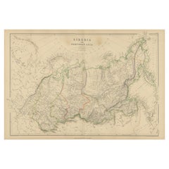
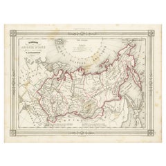
Antique Map of the region of Siberia, Mongolia and Manchuria
$364.24
$455.2920% Off
£271.10
£338.8720% Off
€304
€38020% Off
CA$498.91
CA$623.6420% Off
A$554.90
A$693.6220% Off
CHF 289.75
CHF 362.1920% Off
MX$6,752.53
MX$8,440.6620% Off
NOK 3,700.56
NOK 4,625.7020% Off
SEK 3,470.47
SEK 4,338.0920% Off
DKK 2,314.25
DKK 2,892.8120% Off
Shipping
Retrieving quote...The 1stDibs Promise:
Authenticity Guarantee,
Money-Back Guarantee,
24-Hour Cancellation
About the Item
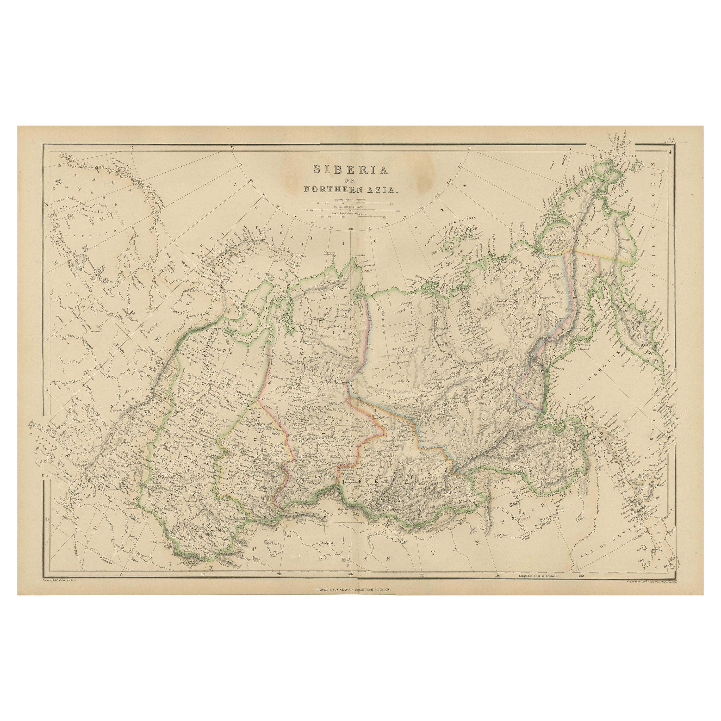
Antique map titled 'Siberia and Chinese Tartary'. Detailed antique map of the region of Siberia, Mongolia and Manchuria. Engraved by J. & C. Walker. Published 1838.
- Dimensions:Height: 13.63 in (34.6 cm)Width: 16.46 in (41.8 cm)Depth: 0.02 in (0.5 mm)
- Materials and Techniques:
- Period:
- Date of Manufacture:1838
- Condition:Strong toning. Shows some wear and creasing. Blank verso. Please study image carefully.
- Seller Location:Langweer, NL
- Reference Number:Seller: BG-13512-41stDibs: LU3054335846482
About the Seller
5.0
Recognized Seller
These prestigious sellers are industry leaders and represent the highest echelon for item quality and design.
Platinum Seller
Premium sellers with a 4.7+ rating and 24-hour response times
Established in 2009
1stDibs seller since 2017
2,502 sales on 1stDibs
Typical response time: <1 hour
- ShippingRetrieving quote...Shipping from: Langweer, Netherlands
- Return Policy
Authenticity Guarantee
In the unlikely event there’s an issue with an item’s authenticity, contact us within 1 year for a full refund. DetailsMoney-Back Guarantee
If your item is not as described, is damaged in transit, or does not arrive, contact us within 7 days for a full refund. Details24-Hour Cancellation
You have a 24-hour grace period in which to reconsider your purchase, with no questions asked.Vetted Professional Sellers
Our world-class sellers must adhere to strict standards for service and quality, maintaining the integrity of our listings.Price-Match Guarantee
If you find that a seller listed the same item for a lower price elsewhere, we’ll match it.Trusted Global Delivery
Our best-in-class carrier network provides specialized shipping options worldwide, including custom delivery.More From This Seller
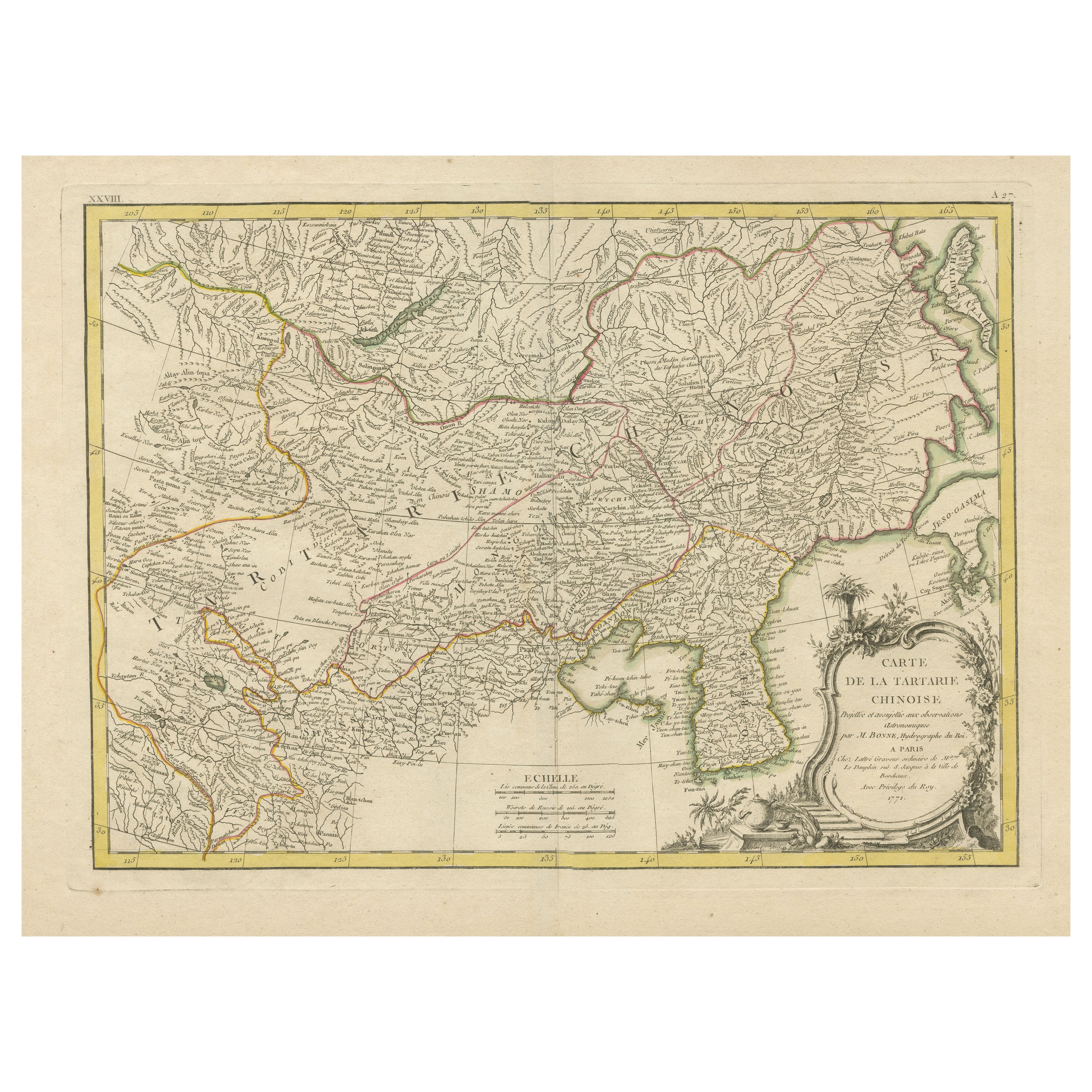
View AllOriginal Old Map of Present-Day Mongolia, Northeast China and Korea
Located in Langweer, NL
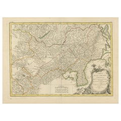
Antique map titled 'Carte de la Tartarie Chinoise. Projettee et assujettie aux observations astronomiques par M. Bonne, Hydrographe du Roi. A Paris, Chez Lattre Graveur, ordinaire de...
Category
Antique Late 18th Century Maps
Materials
Paper
$1,140 Sale Price
20% Off
Antique Map of Siberia, Russia, 1859
Located in Langweer, NL
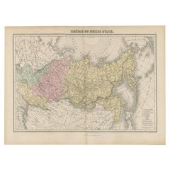
Antique map titled 'Siberia or Northern Asia'. Original antique map of Siberia or Northern Asia. This map originates from ‘The Imperial Atlas of Modern Geography’. Published by W. G....
Category
Antique Mid-19th Century Maps
Materials
Paper
$239 Sale Price
20% Off
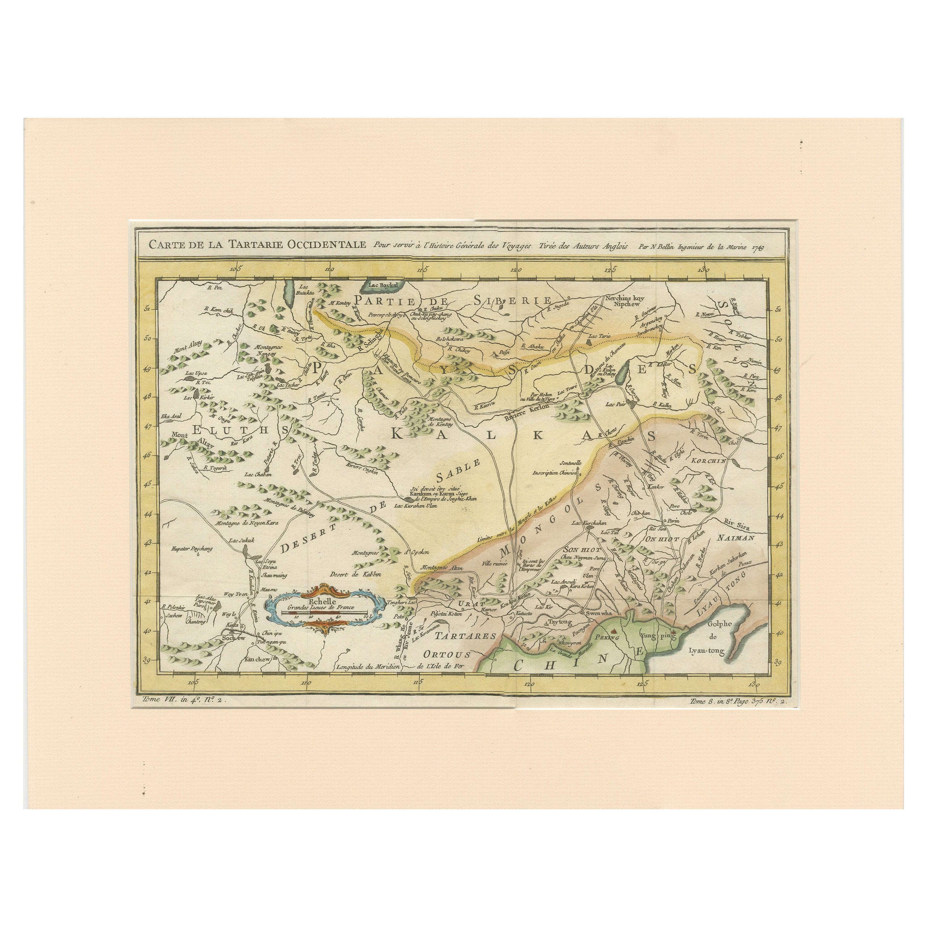
Antique Map of Tartary and Northeast Asia with Hand Coloring
Located in Langweer, NL
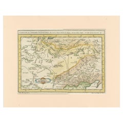
Antique map titled 'Carte de la Tartarie Occidentale'. An interesting map of Tartary and northeast Asia, from Lake Baykal, Partie du Siberia in the north, Pays des Kalkas at the cent...
Category
Antique Mid-18th Century Maps
Materials
Paper
$268 Sale Price
20% Off
Antique Map of Manchuria and the Northeast Portion of Tartary
Located in Langweer, NL
Antique map titled 'Carte de la Tartarie Orientale (..)'. Detailed map of Manchuria and the Northeast portion of Tartary, including Sagallan Anga Hata--Isle de la Bouche...
Category
Antique Mid-18th Century Maps
Materials
Paper

$277 Sale Price
20% Off
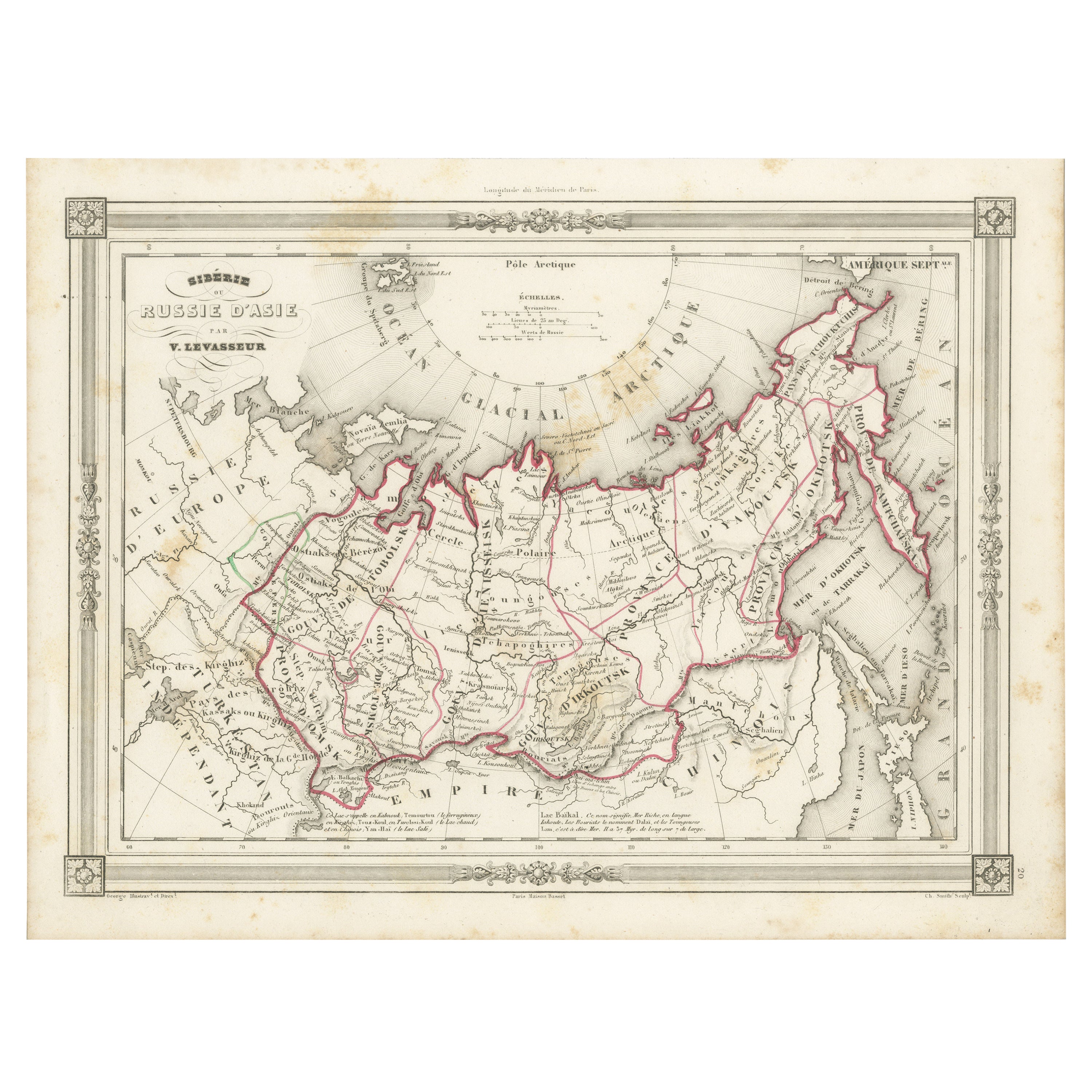
Antique Map of Russia and Siberia by Migeon, 1880
Located in Langweer, NL
Antique map titled 'Sibérie ou Russie d'Asie'. Migeon's map covers the Russian empire in Asia from european Russia and the Ural Mountains to the Bering Strait and from the Arctic Cir...
Category
Antique 19th Century Maps
Materials
Paper
$84 Sale Price
20% Off
Antique Map of Russia in Asia and Siberia, with Frame Style Border
Located in Langweer, NL
Antique map titled 'Sibérie ou Russie d'Asie'. Attractive map of Russia in Asia and Siberia. This map originates from Maison Basset's 1852 edition of 'Atlas Illustre Destine a l'ense...
Category
Antique Mid-19th Century Maps
Materials
Paper
$143 Sale Price
20% Off
You May Also Like
Original Antique Map of China, Arrowsmith, 1820
Located in St Annes, Lancashire
Great map of China
Drawn under the direction of Arrowsmith
Copper-plate engraving
Published by Longman, Hurst, Rees, Orme and Brown, 1820
Unfr...
Category
Antique 1820s English Maps
Materials
Paper

1860 Large Map "Carte De La Siberie Russie D'asie, " Ric.R0001
Located in Norton, MA
Large 1860 map "Carte De La Siberie Russie D'Asie," R-0001
" Authentic" - 1860 map "Carte De La Siberie Russie D'Asie,"
Dimension: Paper: 68 cm W x 51 cm H ; Sight: 51cm W x 4...
Category
Antique 19th Century Unknown Maps
Materials
Paper

Antique 1803 Italian Map of Asia Including China Indoneseia India
Located in Amsterdam, Noord Holland
Antique 1803 Italian Map of Asia Including China Indoneseia India
Very nice map of Asia. 1803.
Additional information:
Type: Map
Country of Manufacturing: Europe
Period: 19th centu...
Category
Antique 19th Century European Maps
Materials
Paper

$584 Sale Price
20% Off
Super Rare Antique French Map of Chine and the Chinese Empire, 1780
Located in Amsterdam, Noord Holland
Super Rare Antique French Map of Chine and the Chinese Empire, 1780
Very nice map of Asia. 1780 Made by Bonne.
Additional information:
Type: Map
...
Category
Antique 18th Century European Maps
Materials
Paper

$584 Sale Price
33% Off
1849 Map of "Europaische Russland", 'Meyer Map of European Russia', Ric. R017
Located in Norton, MA
1849 Map of
"Europaische Russland"
( Meyer Map of European Russia)
Ric.r017
A lovely map of European Russia dating to 1849 by Joseph Meyer. It covers the European portions of...
Category
Antique 19th Century Unknown Maps
Materials
Paper

Large Original Vintage Map of China, circa 1920
Located in St Annes, Lancashire
Great map of China.
Original color. Good condition.
Published by Alexander Gross
Unframed.
Category
Vintage 1920s English Edwardian Maps
Materials
Paper

More Ways To Browse
Mongolia Antique
Antique Mongolian Furniture
Mongolian Antique
Giacometti Chairs
Antique Rug Wool Navy Blue Red
Bauhaus Flower Stand
French Table With Drawers
North Carolina Furniture
Antique Silver Platter
Boat Blueprint
Cream Plates
Vintage Art Deco Rugs
Vintage Serving Forks
Brewery Signs
Herati Rug
Venice Wood
Gold Leaf Furniture Black
Italian Wood Console Tables