Items Similar to Antique Map of Siberia, Russia, 1859


Want more images or videos?
Request additional images or videos from the seller
1 of 6
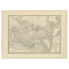
Antique Map of Siberia, Russia, 1859
About the Item
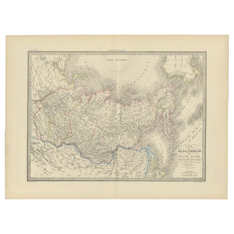
Antique map titled 'Siberia or Northern Asia'. Original antique map of Siberia or Northern Asia. This map originates from ‘The Imperial Atlas of Modern Geography’. Published by W. G. Blackie, 1859.
- Dimensions:Height: 14.57 in (37 cm)Width: 21.26 in (54 cm)Depth: 0.02 in (0.5 mm)
- Materials and Techniques:
- Period:
- Date of Manufacture:1859
- Condition:Wear consistent with age and use. General age-related toning. some foxing, Please study image carefully.
- Seller Location:Langweer, NL
- Reference Number:
About the Seller
5.0
Platinum Seller
These expertly vetted sellers are 1stDibs' most experienced sellers and are rated highest by our customers.
Established in 2009
1stDibs seller since 2017
1,928 sales on 1stDibs
Typical response time: <1 hour
- ShippingRetrieving quote...Ships From: Langweer, Netherlands
- Return PolicyA return for this item may be initiated within 14 days of delivery.
More From This SellerView All
- Antique Map of Siberia and Russia, c.1885Located in Langweer, NLAntique map titled 'Siberie ou Russie d?Asie'. This is a fine example of J. Migeon's map of Russia in Asia. Migeon's map covers the Russian empire in Asia from european Russia and th...Category
Antique 19th Century Maps
MaterialsPaper
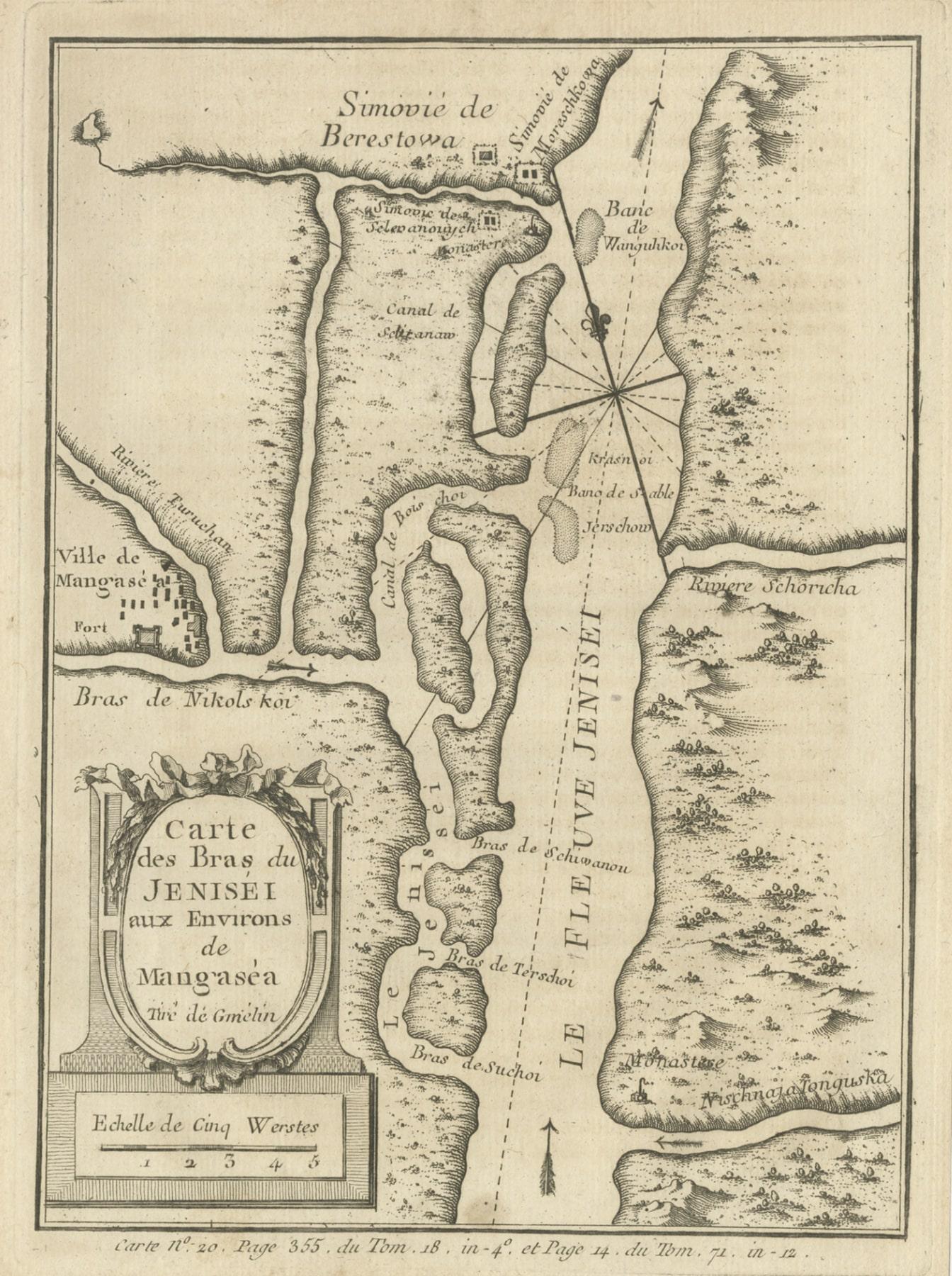
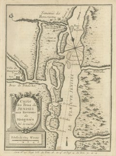
- Antique Map of the Yenisei River in Siberia, Russia, 1768By PrevostLocated in Langweer, NLAntique map titled 'Carte des Bras du Jenisei (..)'. Map of the Yenisei River and surroundings, Siberia. This print originates from volume 18 of 'Histoire generale des voyages (..)' ...Category
Antique 18th Century Maps
MaterialsPaper
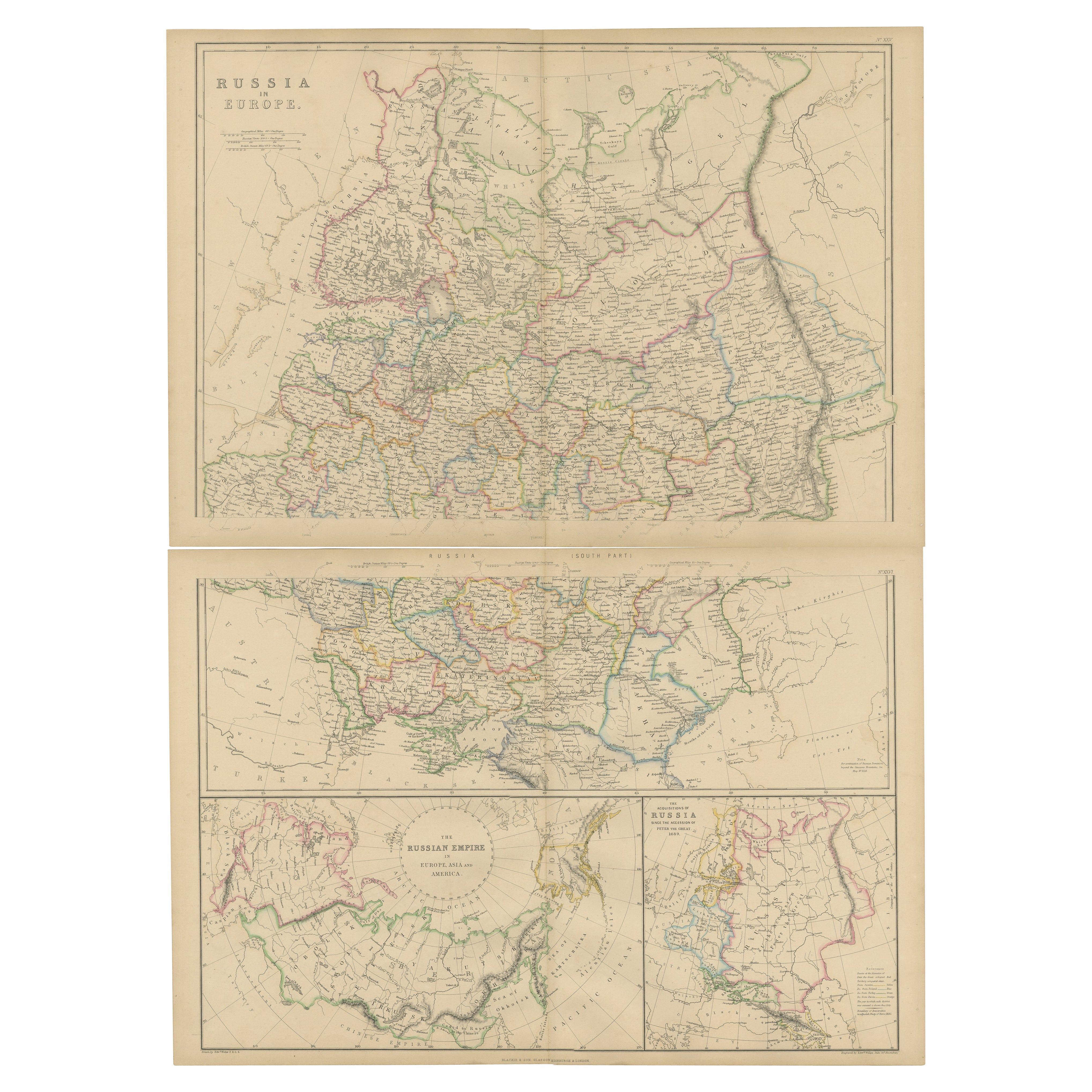
- Set of 2 Antique Maps of Russia in Europe by W. G. Blackie, 1859Located in Langweer, NLAntique map titled 'Russia in Europe'. Original antique map of Russia in Europe with inset maps of the Russian Empire in Europe, Asia and America and the acquisition of Russia since ...Category
Antique Mid-19th Century Maps
MaterialsPaper
- Antique Map of Siberia by Levasseur '1875'Located in Langweer, NLAntique map titled 'Carte de la Russie d'Asie Sibérie'. Large map of Siberia. This map originates from 'Atlas de Géographie Moderne Physique et Politique' by A. Levasseur. Published ...Category
Antique Late 19th Century Maps
MaterialsPaper
- Antique Map of Siberia by Lapie, 1842Located in Langweer, NLAntique map titled 'Carte de la Sibérie ou Russie d'Asie'. Map of Siberia. This map originates from 'Atlas universel de géographie ancienne et moderne (..)' by Pierre M. Lapie and Al...Category
Antique 19th Century Maps
MaterialsPaper
- Antique Map of Siberia by Bellin, 1754Located in Langweer, NLAntique map titled 'Carte de la Siberie'. Detailed map of Siberia, extending from the White Sea and the Caspian Sea in the west to Irkuckoi Province, Jakutky on the Lena River and regions just to the east. Centered on the Jenisi River. Originates from Prévost's 'Histoire Générale des Voyages'. Artists and Engravers: Jacques-Nicolas Bellin (1703-1772) was among the most important mapmakers of the eighteenth century. In 1721, at age 18, he was appointed hydrographer (chief cartographer) to the French Navy. In August 1741, he became the first Ingénieur de la Marine of the Depot des cartes...Category
Antique 18th Century Maps
MaterialsPaper


You May Also Like
- Large Antique 1859 Map of North AmericaLocated in Sag Harbor, NYThis Map was made by Augustus Mitchell in 1859 It is in amazing condition for being 163 years old. This price is for the rolled up easy to ship version of this piece. I will be Frami...Category
Antique Mid-19th Century American Maps
MaterialsCanvas, Paper

- Original Antique Map of Russia By Arrowsmith. 1820Located in St Annes, LancashireGreat map of Russia Drawn under the direction of Arrowsmith Copper-plate engraving Published by Longman, Hurst, Rees, Orme and Brown, 1820 Unframed.Category
Antique 1820s English Maps
MaterialsPaper
- Antique Map of Principality of MonacoBy Antonio Vallardi EditoreLocated in Alessandria, PiemonteST/619 - "Old Geographical Atlas of Italy - Topographic map of ex-Principality of Monaco" - ediz Vallardi - Milano - A somewhat special edition ---Category
Antique Late 19th Century Italian Other Prints
MaterialsPaper
- Original Antique Map of India. C.1780Located in St Annes, LancashireGreat map of India Copper-plate engraving Published C.1780 Three small worm holes to right side of map and one bottom left corner Unframed.Category
Antique Early 1800s English Georgian Maps
MaterialsPaper

- Original Antique Map of Italy. Arrowsmith. 1820Located in St Annes, LancashireGreat map of Italy Drawn under the direction of Arrowsmith Copper-plate engraving Published by Longman, Hurst, Rees, Orme and Brown, 1820 Unframed.Category
Antique 1820s English Maps
MaterialsPaper
- Original Antique Map of China, Arrowsmith, 1820Located in St Annes, LancashireGreat map of China Drawn under the direction of Arrowsmith Copper-plate engraving Published by Longman, Hurst, Rees, Orme and Brown, 1820 Unfr...Category
Antique 1820s English Maps
MaterialsPaper


Recently Viewed
View AllMore Ways To Browse
Imperial Russian Antiques
Russian Antique Collectables
Map Russia
Russian Map
Map Of Russia
Maps Of Russia
Antique Russian Map
Antique Map Russia
Antique Map Of Russia
Antique Maps Of Russia
Antique Maps Of Islands
18th Russian
Antique Maps Of Holland
Antique Maps Of America
Antique Map Of America
Antique Furniture In Edinburgh
Victorian Tear
Antique 17th Century Map