Items Similar to Original Old Map of Present-Day Mongolia, Northeast China and Korea


Want more images or videos?
Request additional images or videos from the seller
1 of 6
Original Old Map of Present-Day Mongolia, Northeast China and Korea
About the Item
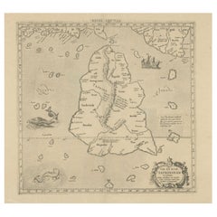
Antique map titled 'Carte de la Tartarie Chinoise. Projettee et assujettie aux observations astronomiques par M. Bonne, Hydrographe du Roi. A Paris, Chez Lattre Graveur, ordinaire de Mseur. Le Dauphin, rue S. Jacques a la Ville de Bordeaux. Avec privilege du Roy. 1771'. Original old map of the region including present-day Mongolia, northeast China and Korea. Published in Paris by Lattré in “Atlas Moderne”, 1771. This atlas contained many maps by Rigobert Bonne.
- Dimensions:Height: 15.24 in (38.7 cm)Width: 21.19 in (53.8 cm)Depth: 0.02 in (0.5 mm)
- Materials and Techniques:
- Period:
- Date of Manufacture:1771
- Condition:Wear consistent with age and use. General age-related toning. Original folding line. Minor wear and soiling, blank verso. Small repair on tiny holes above scale. Please study image carefully.
- Seller Location:Langweer, NL
- Reference Number:
About the Seller
5.0
Platinum Seller
These expertly vetted sellers are 1stDibs' most experienced sellers and are rated highest by our customers.
Established in 2009
1stDibs seller since 2017
1,928 sales on 1stDibs
Typical response time: <1 hour
- ShippingRetrieving quote...Ships From: Langweer, Netherlands
- Return PolicyA return for this item may be initiated within 14 days of delivery.
More From This SellerView All
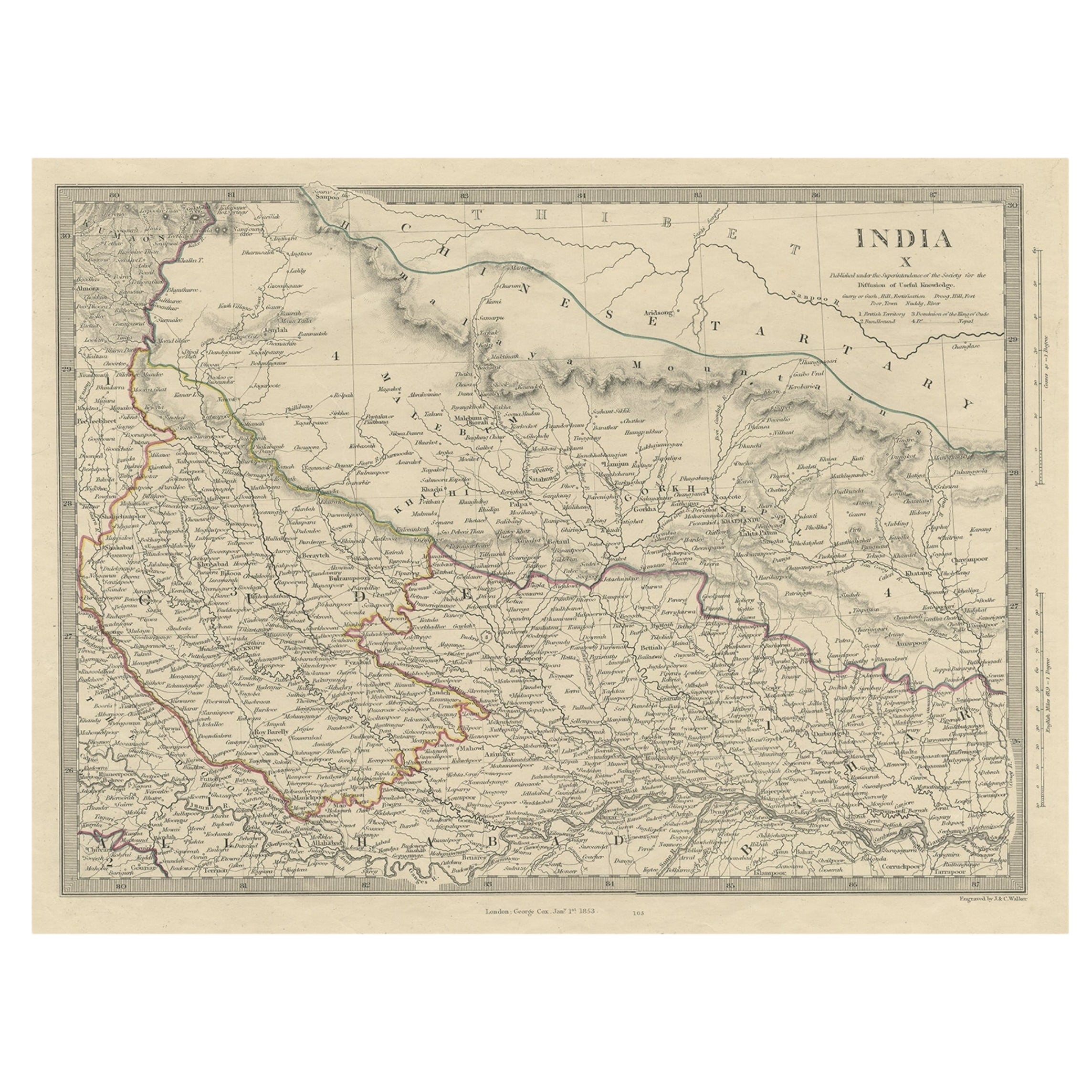
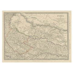
- Original Old Map Northeast India, incl Part of Himalayas and China, 1853Located in Langweer, NLAntique map titled 'India X'. Old map of the the northeast region of India, including part of Himalayas and China. Great detail of landforms, rivers and water bodies, cities, towns...Category
Antique 1850s Maps
MaterialsPaper
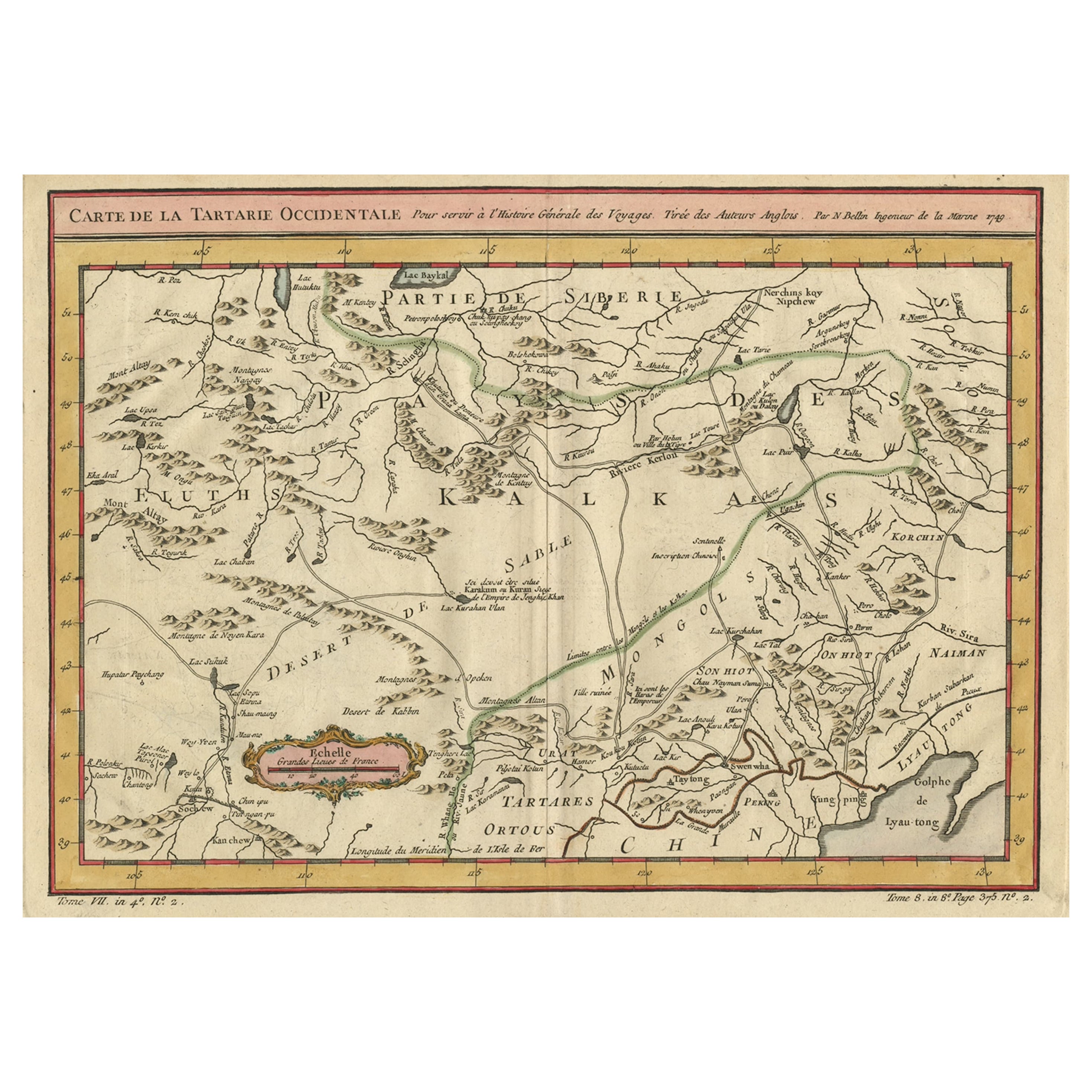
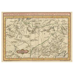
- Old Hand-Colored Map of Western Tartary with Focus on Present-Day Mongolia, 1749Located in Langweer, NLAntique map titled 'Carte de la Tartarie Occidentale pour Servir a l'Histoire Générale des Voyages. Tirée des Auteurs Anglois.' This map covers western Tartary and focuses on the...Category
Antique 1740s Maps
MaterialsPaper
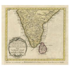
- Original Antique Map of Southern India and Ceylon 'Present-Day Sri Lanka'By Jakob van der SchleyLocated in Langweer, NLAntique map titled 'Suite de la Carte de l'Indoustan (..) - Vervolg van de Kaart van Hindoestan (..)'. Original antique map of Southern India and Ceylon (present-day Sri Lanka). This...Category
Antique Mid-18th Century Maps
MaterialsPaper
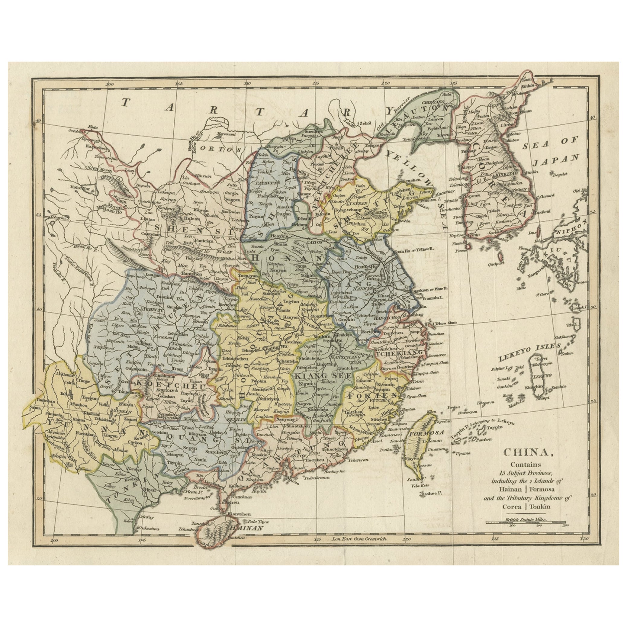
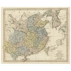
- Original Old China Map, From Korea and the Sea of Japan to Teypin Island, 1803Located in Langweer, NLAntique map titled 'China, Contains 15 Subject Provinces Including the 2 Islands of Hainan, Formosa and the Tributary Kingdoms of Corea, Tonkin'. Old map depicting China, extendi...Category
Antique Early 1800s Maps
MaterialsPaper
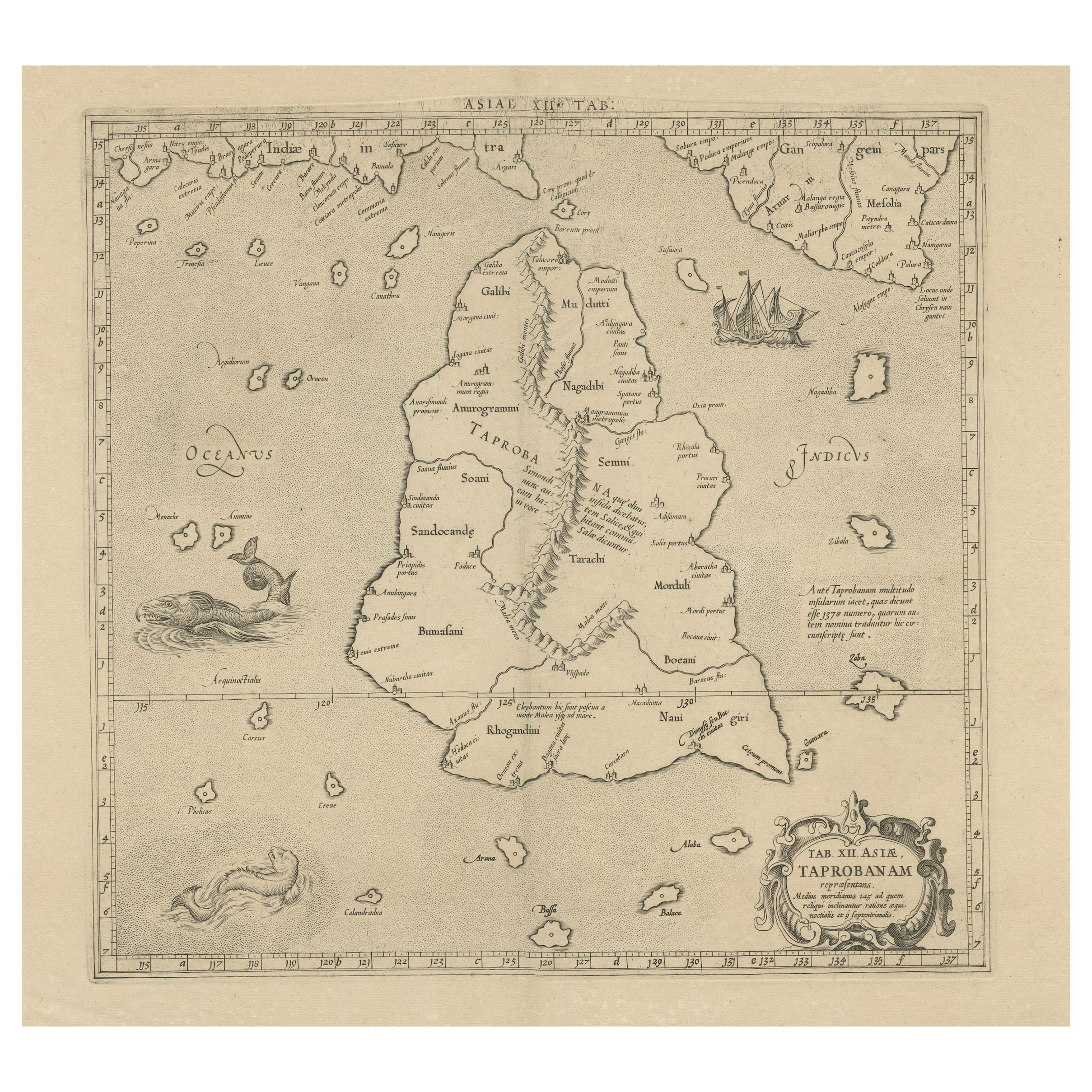
- Rare Original Antique Ptolemy Map of Ceylon, Present Day Sri LankaLocated in Langweer, NLOriginal antique map titled 'Tab XII Asiae Taprobanam (..)'. For this map of Toprobana (Sri Lanka), Ptolemy drew on the accounts of travelers and sailors and though the information was secondhand and often inaccurate, it represented the most advanced account of the world's geography at that time. This map depicts the island with the typical misconceptions of the period with the enlarged island straddling the Equator and nearly divided by a ridge of mountains. A small part of India is incorrectly shown in the northeast corner of the map and a spurious coastline labeled Gangem fills the upper right corner. The stipple engraved sea contains an oriental ship...Category
Antique Late 17th Century Maps
MaterialsPaper
- Antique Map of Tartary and Northeast Asia, c.1750Located in Langweer, NLAntique map titled 'Carte de la tartarie occidentale'. An interesting map of Tartary and northeast Asia, from Lake Baykal, Partie du Siberia in the north, Pays des Kalkas at the cent...Category
Antique 18th Century Maps
MaterialsPaper

You May Also Like
- Original Antique Map of China, Arrowsmith, 1820Located in St Annes, LancashireGreat map of China Drawn under the direction of Arrowsmith Copper-plate engraving Published by Longman, Hurst, Rees, Orme and Brown, 1820 Unfr...Category
Antique 1820s English Maps
MaterialsPaper
- Original Antique Map of China by Thomas Clerk, 1817Located in St Annes, LancashireGreat map of China Copper-plate engraving Drawn and engraved by Thomas Clerk, Edinburgh. Published by Mackenzie And Dent, 1817 Unframed.Category
Antique 1810s English Maps
MaterialsPaper
- Old Nautical Map of CorsicaLocated in Alessandria, PiemonteST/556/1 - Old map of Corsica isle, surveyed by Captain Hell, of the French Royal Navy in 1824, engraved and published on 1874, with additions and corre...Category
Antique Early 19th Century English Other Prints
MaterialsPaper
- Old Horizontal Map of EnglandBy TassoLocated in Alessandria, PiemonteST/520 - Old rare Italian map of England, dated 1826-1827 - by Girolamo Tasso, editor in Venise, for the atlas of M.r Le-Sage.Category
Antique Early 19th Century Italian Other Prints
MaterialsPaper
- Original Antique Map of Italy. C.1780Located in St Annes, LancashireGreat map of Italy Copper-plate engraving Published C.1780 Unframed.Category
Antique Early 1800s English Georgian Maps
MaterialsPaper

- Original Antique Map of Asia. C.1780Located in St Annes, LancashireGreat map of Asia Copper-plate engraving Published C.1780 Two small worm holes to right side of map Unframed.Category
Antique Early 1800s English Georgian Maps
MaterialsPaper


Recently Viewed
View AllMore Ways To Browse
Antique Map Bahamas
Antique Map Ontario
Antique Maps Ontario
Map Lebanon
Antique Map Montreal
Antique Maps San Diego
Lebanon Antique Map
Montreal Map
Antique Furniture Perth Australia
Antique Maps Perth
Barbados Map
Antique Map Connecticut
Antique Map Of Republic Of Texas
Antique Route 66
Giovanni Maria Cassini On Sale
Antique Map Cleveland
Antique Maps Washington Dc
Daniel Bautista