Items Similar to Antique Map of Southeast Asia and China by Kiepert, c.1870


Want more images or videos?
Request additional images or videos from the seller
1 of 5
Antique Map of Southeast Asia and China by Kiepert, c.1870
$224.07
£167.72
€190
CA$308.38
A$343.72
CHF 180.34
MX$4,197.43
NOK 2,283.50
SEK 2,158.25
DKK 1,446.41
About the Item
Antique map titled 'Ostindien und China'. Old map of Southeast Asia and China. This map originates from 'H. Kiepert's Kleiner Atlas der Neueren Geographie für Schule und Haus'. Artists and Engravers: Kiepert, Heinrich (1818-1899), was a German geographer, and the son of a wealthy businessman.
Artist: Kiepert, Heinrich (1818-1899), was a German geographer, and the son of a wealthy businessman.
Antique prints have long been appreciated for both their aesthetic and investment value. They were the product of engraved, etched or lithographed plates. These plates were handmade out of wood or metal, which required an incredible level of skill, patience and craftsmanship. Whether you have a house with Victorian furniture or more contemporary decor an old engraving can enhance your living space. We offer a wide range of authentic antique prints for any budget.
- Creator:Thomas Kitchin (Author)
- Dimensions:Height: 13.78 in (35 cm)Width: 17.84 in (45.3 cm)Depth: 0 in (0.01 mm)
- Materials and Techniques:
- Period:
- Date of Manufacture:circa 1870
- Condition:Condition: Good, general age-related toning. Split on folding line, please study image carefully.
- Seller Location:Langweer, NL
- Reference Number:Seller: BG-06670-61stDibs: LU3054327622562
About the Seller
5.0
Recognized Seller
These prestigious sellers are industry leaders and represent the highest echelon for item quality and design.
Platinum Seller
Premium sellers with a 4.7+ rating and 24-hour response times
Established in 2009
1stDibs seller since 2017
2,513 sales on 1stDibs
Typical response time: <1 hour
- ShippingRetrieving quote...Shipping from: Langweer, Netherlands
- Return Policy
Authenticity Guarantee
In the unlikely event there’s an issue with an item’s authenticity, contact us within 1 year for a full refund. DetailsMoney-Back Guarantee
If your item is not as described, is damaged in transit, or does not arrive, contact us within 7 days for a full refund. Details24-Hour Cancellation
You have a 24-hour grace period in which to reconsider your purchase, with no questions asked.Vetted Professional Sellers
Our world-class sellers must adhere to strict standards for service and quality, maintaining the integrity of our listings.Price-Match Guarantee
If you find that a seller listed the same item for a lower price elsewhere, we’ll match it.Trusted Global Delivery
Our best-in-class carrier network provides specialized shipping options worldwide, including custom delivery.More From This Seller
View AllAntique Map of Asia from a German School Atlas, c.1870
Located in Langweer, NL
Antique map titled 'Asien'. Old map of the Asian continent. This map originates from 'H. Kiepert's Kleiner Atlas der Neueren Geographie für Schule und Haus'.
Artists and Engravers:...
Category
Antique 19th Century Maps
Materials
Paper

$134 Sale Price
20% Off
Antique Map of Asia by A & C, Black, 1870
Located in Langweer, NL
Antique map titled 'Asia'. Original antique map of Asia. This map originates from ‘Black's General Atlas of The World’. Published by A & C. Black, 1870.
Category
Antique Late 19th Century Maps
Materials
Paper

$235 Sale Price
20% Off
Antique Map of Asia by Johnson, 1872
Located in Langweer, NL
Antique map titled 'Johnson's Asia'. Original map of Asia. This map originates from 'Johnson's New Illustrated Family Atlas of the World' by A.J. Johnson. Published, 1872.
Category
Antique Late 19th Century Maps
Materials
Paper

$330 Sale Price
20% Off
Antique Map of Asia by Young, c.1860
Located in Langweer, NL
Antique map titled 'Asia'. Steel engraved map of Asia by Francis Young.
Artists and Engravers: Engraved by Lewis Becker. Published by S.O. Beeton.
We sell original antique maps to...
Category
Antique 19th Century Maps
Materials
Paper

$127 Sale Price
20% Off
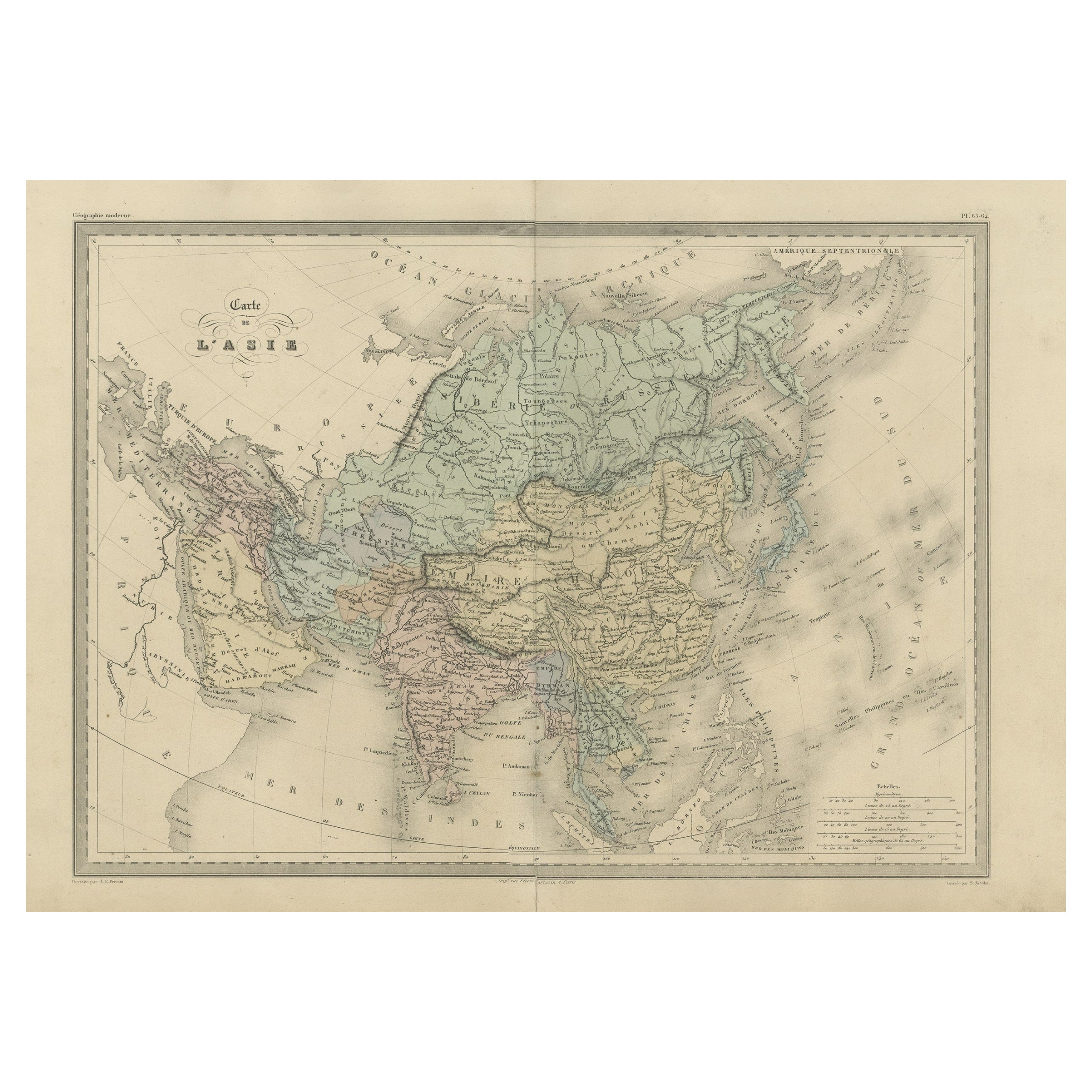
Antique Map of Asia by Malte-Brun, 1880
Located in Langweer, NL
Map Pl. 63 - 64: 'Carte de l'Asie.' This map shows Asia. This original antique map originates from 'Atlas de la Geographie Universelle ou Description de toutes les parties du monde s...
Category
Antique 19th Century Maps
Materials
Paper
$169 Sale Price
20% Off
Antique Map of Southern Asia by Walker, c.1840
Located in Langweer, NL
"Original antique map of Southern Asia, the East Indies and the Indian Ocean. Also shows part of Australia. Published circa 1840. Artists and Engravers: ...
Category
Antique 19th Century Maps
Materials
Paper

$99 Sale Price
20% Off
You May Also Like
Antique 1803 Italian Map of Asia Including China Indoneseia India
Located in Amsterdam, Noord Holland
Antique 1803 Italian Map of Asia Including China Indoneseia India
Very nice map of Asia. 1803.
Additional information:
Type: Map
Country of Manufacturing: Europe
Period: 19th centu...
Category
Antique 19th Century European Maps
Materials
Paper

$584 Sale Price
20% Off
Large Original Vintage Map of S.E Asia, with a Vignette of Singapore
Located in St Annes, Lancashire
Great map of South East Asia
Original color. Good condition
Published by Alexander Gross
Unframed.
Category
Vintage 1920s English Maps
Materials
Paper

Large Original Antique Map of Asia by Sidney Hall, 1847
Located in St Annes, Lancashire
Great map of Asia
Drawn and engraved by Sidney Hall
Steel engraving
Original colour outline
Published by A & C Black. 1847
Unframed
Free shipping
Category
Antique 1840s Scottish Maps
Materials
Paper

Original Antique Map of South East Asia by Thomas Clerk, 1817
Located in St Annes, Lancashire
Great map of South East Asia
Copper-plate engraving
Drawn and engraved by Thomas Clerk, Edinburgh.
Published by Mackenzie And Dent, 1817
Unframed.
Category
Antique 1810s English Maps
Materials
Paper

Original Antique Map of China, Arrowsmith, 1820
Located in St Annes, Lancashire
Great map of China
Drawn under the direction of Arrowsmith
Copper-plate engraving
Published by Longman, Hurst, Rees, Orme and Brown, 1820
Unfr...
Category
Antique 1820s English Maps
Materials
Paper

Super Rare Antique French Map of Chine and the Chinese Empire, 1780
Located in Amsterdam, Noord Holland
Super Rare Antique French Map of Chine and the Chinese Empire, 1780
Very nice map of Asia. 1780 Made by Bonne.
Additional information:
Type: Map
...
Category
Antique 18th Century European Maps
Materials
Paper

$584 Sale Price
32% Off
More Ways To Browse
Thomas Germany
Wood And Sons Plate
Chinese Etched Plate
Heinrich China
John Speed Antique Maps
Malaysia Map
Sebastian Munster
Antique Map Chile
Antique Map Of Boston
Ipswich Antique Furniture
Maps Balkans
Missouri Map
Antique Maps Of Texas
Antique Maps Virginia
Antique Railroad Scale
Jamaican Antique
Hindeloopen Furniture
Romania Map