Items Similar to Antique Map of the Strait Between Nova Zembla and the Mainland of Russia


Want more images or videos?
Request additional images or videos from the seller
1 of 5
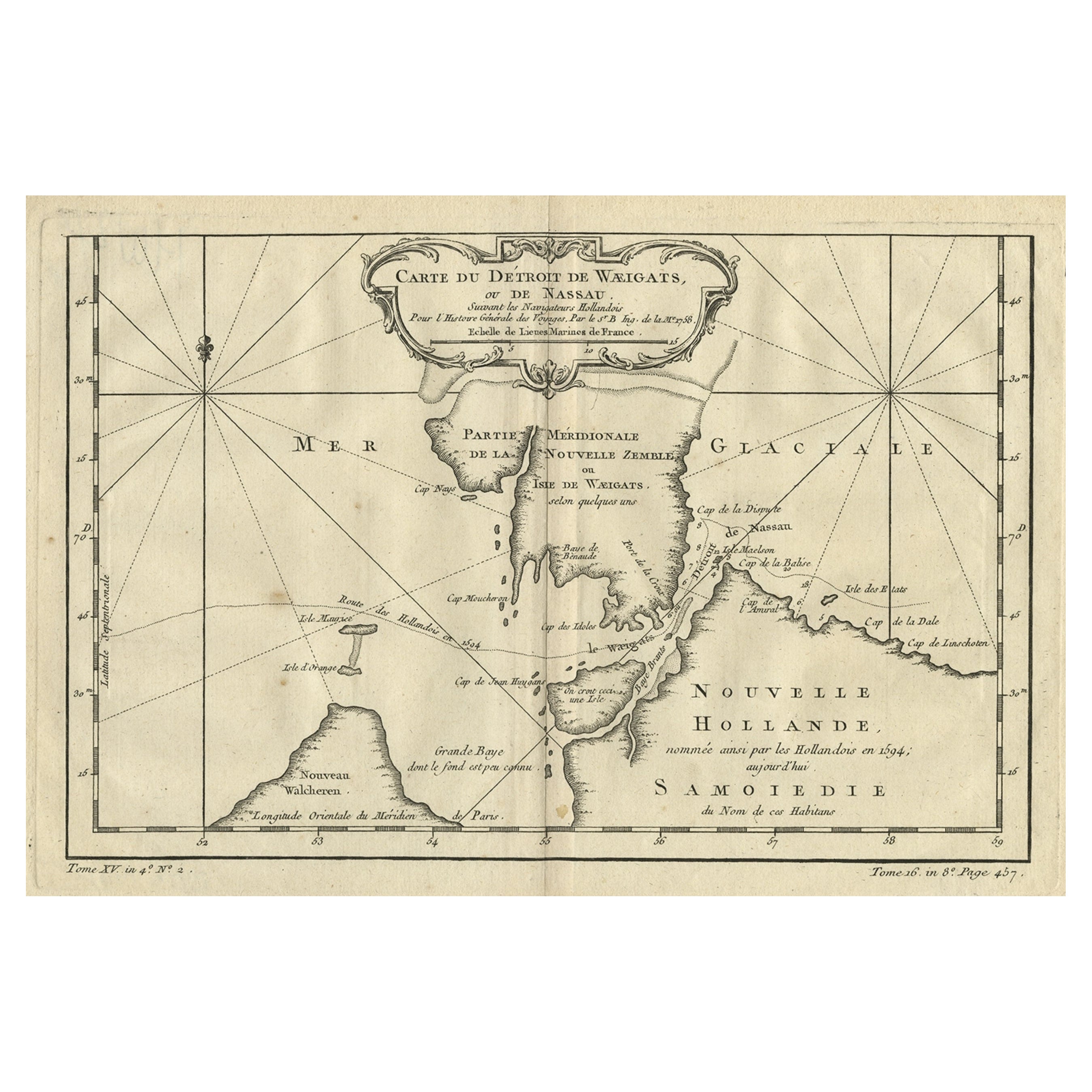
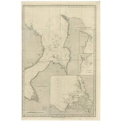
Antique Map of the Strait Between Nova Zembla and the Mainland of Russia
$349.86
$437.3220% Off
£260.40
£325.5020% Off
€292
€36520% Off
CA$479.22
CA$599.0220% Off
A$532.99
A$666.2420% Off
CHF 278.31
CHF 347.8920% Off
MX$6,485.98
MX$8,107.4820% Off
NOK 3,554.49
NOK 4,443.1120% Off
SEK 3,333.48
SEK 4,166.8520% Off
DKK 2,222.89
DKK 2,778.6220% Off
Shipping
Retrieving quote...The 1stDibs Promise:
Authenticity Guarantee,
Money-Back Guarantee,
24-Hour Cancellation
About the Item
Antique map titled 'Carte du Detroit de Waeigats ou de Nassau'. Detailed regional map of the Strait of Waeigats in the Arctic Sea. Includes a decorative title cartouche. One of the maps produced by Nichlas Bellin for Prevost d'Exiles' influential travel book 'l'Histoire Generale des Voyages'.
- Dimensions:Height: 14.85 in (37.7 cm)Width: 18.98 in (48.2 cm)Depth: 0.2 in (5 mm)
- Materials and Techniques:
- Period:
- Date of Manufacture:1764
- Condition:Please study image carefully.
- Seller Location:Langweer, NL
- Reference Number:Seller: BG-062821stDibs: LU305439781931
About the Seller
5.0
Recognized Seller
These prestigious sellers are industry leaders and represent the highest echelon for item quality and design.
Platinum Seller
Premium sellers with a 4.7+ rating and 24-hour response times
Established in 2009
1stDibs seller since 2017
2,502 sales on 1stDibs
Typical response time: <1 hour
- ShippingRetrieving quote...Shipping from: Langweer, Netherlands
- Return Policy
Authenticity Guarantee
In the unlikely event there’s an issue with an item’s authenticity, contact us within 1 year for a full refund. DetailsMoney-Back Guarantee
If your item is not as described, is damaged in transit, or does not arrive, contact us within 7 days for a full refund. Details24-Hour Cancellation
You have a 24-hour grace period in which to reconsider your purchase, with no questions asked.Vetted Professional Sellers
Our world-class sellers must adhere to strict standards for service and quality, maintaining the integrity of our listings.Price-Match Guarantee
If you find that a seller listed the same item for a lower price elsewhere, we’ll match it.Trusted Global Delivery
Our best-in-class carrier network provides specialized shipping options worldwide, including custom delivery.More From This Seller
View AllAntique Map of Nova Zembla 'Russia' by J.N. Bellin, 1757
Located in Langweer, NL
Decorative map of Nova Zembla and environs in the Arctic Sea. Includes a large decorative title cartouche. One of the maps produced by Jacques-Nicolas Bellin for Prevost d'Exiles inf...
Category
Antique Mid-18th Century Maps
Materials
Paper

$263 Sale Price
20% Off
Antique Map of Eastern Siberia by Bellin '1768'
Located in Langweer, NL
Antique map titled 'Suite de la Carte de la Siberie et le Pays de Kamtchatka'. Original antique map of the eastern portion of Siberia, centered on eastern Russia and the Mer d'Ochozk (Sea of Okhotsk) showing the Kamchatka Peninsula and I. de Beringe and I. Sagalin. The map shows the tracks of Russian ships...
Category
Antique Mid-18th Century Maps
Materials
Paper

$287 Sale Price
20% Off
Antique Map of Nova Zembla ‘Russia’ by J.N. Bellin, 1758
Located in Langweer, NL
An interesting map of Nova Zembla and surrounding areas. With details on the eastern tip of Nova Zembla of the place where the stranded Dutch sailors under Willem Barentsz spent the ...
Category
Antique Mid-18th Century Maps
Materials
Paper

$230 Sale Price
20% Off
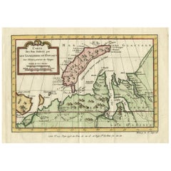
Decorative Original Old Map of Nova Zembla and the Russian Mainland, ca.1760
Located in Langweer, NL
Antique map titled 'Carte Des Pais Habites par les Samojedes et Ostiacs.'
Map of Novaya Zemlya and the Russian mainland. Source unknown, to be determined.
Artists and Engraver...
Category
Antique 1760s Maps
Materials
Paper
$431 Sale Price
20% Off
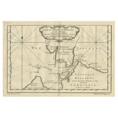
Map of the Russian Islands of Novaya Zemlya and Pechorskaya Guba, 1758
Located in Langweer, NL
Antique map titled 'Carte du detroit de Waeigats ou de Nassau.'
Map of the Russian islands of Novaya Zemlya (Nova Zembla) and Pechorskaya Guba, here Nouvelle Zemble and Grande Ba...
Category
Antique 1750s Maps
Materials
Paper
$249 Sale Price
20% Off
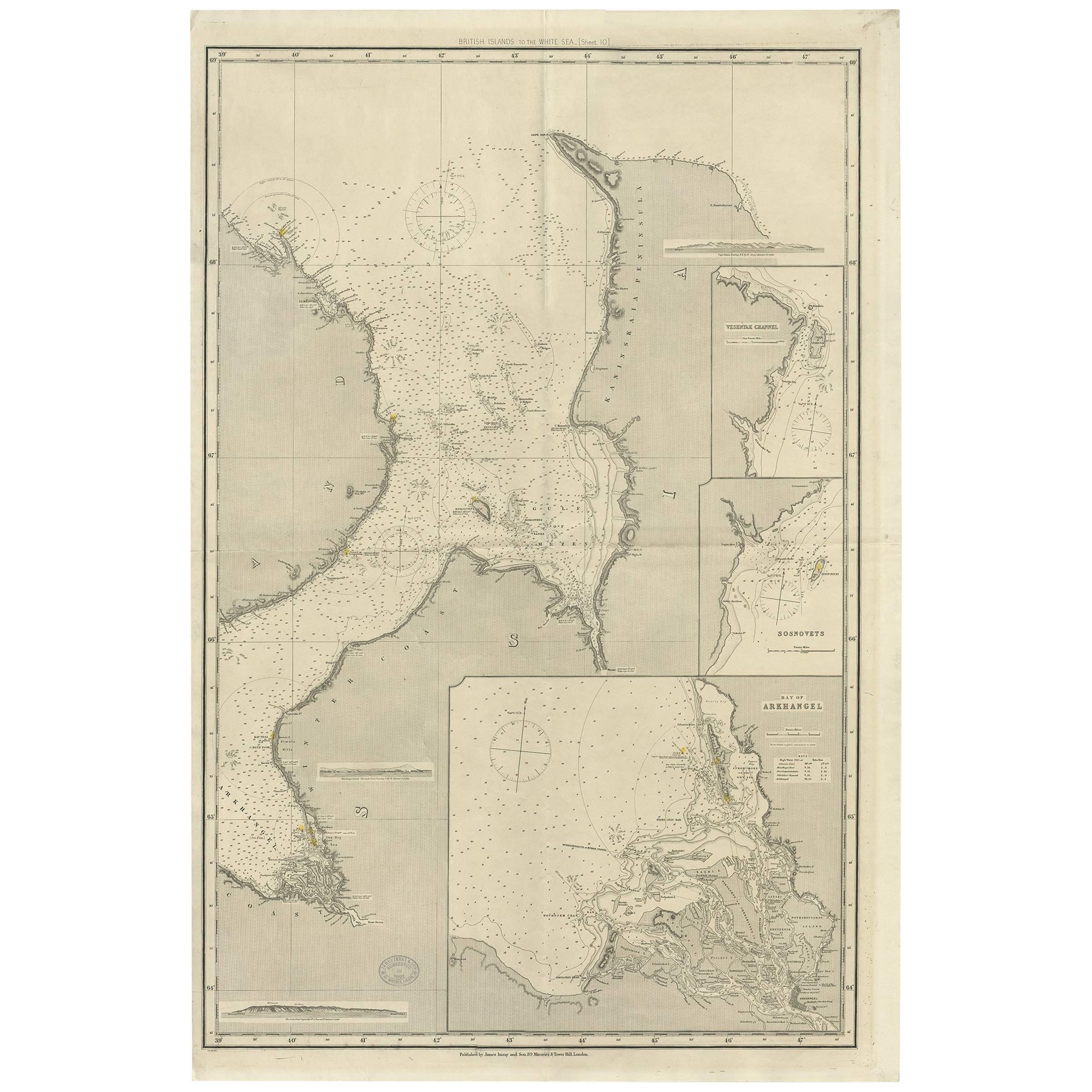
Antique Map of the British Islands to the White Sea by J. Imray
Located in Langweer, NL
Antique large nautical chart of the British Islands to the White Sea. With insets of Veshnyak Channel, Sosnovets and the Bay of Arkhangel. Published by James Irmay and Son, circa 1875.
Category
Antique Late 19th Century Maps
Materials
Paper
You May Also Like
Antique Lithography Map, Black Sea, English, Framed, Cartography, Victorian
Located in Hele, Devon, GB
This is an antique lithography map of the Black Sea region. An English, framed atlas engraving of cartographic interest by John Rapkin, dating to the early Victorian period and later...
Category
Antique Mid-19th Century British Early Victorian Maps
Materials
Wood

Northwest Coast and Isle of Man Map
Located in Cheshire, GB
Greenville Collins Northwest Coast and Isle of Man. hand coloured chart, encased in an ebonised frame.
Dimensions
Height 26.5 Inches
Width 30 Inches
Depth 1 Inches
Category
Early 20th Century British Maps
Materials
Paper

$520 Sale Price
20% Off
1814 Map of "Russian Empire" Ric.r032
Located in Norton, MA
1814 Map of
"Russian Empire"
Ric.r032
Russian Empire. Description: This is an 1814 John Thomson map of the Russian Empire. The map depicts the region from the Baltic Sea, Prussia, and Sweden to the Aleutian Islands and from the Arctic Ocean to the Yellow River. Highly detailed, myriad cities, towns, and villages are labeled throughout, including St. Petersburg, Moscow, Minsk, Kiev, and Kharkov. Rivers and mountain ranges are also identified, as are islands and numerous locations along the coastlines. It is important to note that the long-disputed sea between Korea and Japan is identified as the 'Sea of Japan.
Historical Context:
In 1815, Tsarist Russia emerged from the Napoleonic Wars economically insolvent and politically fearful of the Revolutionary fervor that had just swept through Europe. In order to shore up Russia's economic position, the Tsars began an aggressive series of expansions into the Caucuses and Central Asia that would vastly increase the landmass of the Russian Empire.
Publication History
Thomson maps are known for their stunning color, awe inspiring size, and magnificent detail. Thomson's work, including this map, represents some of the finest cartographic art...
Category
Antique 19th Century Unknown Maps
Materials
Paper

Antique Lithography Map, West Africa, English, Framed, Cartography, Victorian
Located in Hele, Devon, GB
This is an antique lithography map of Western Africa. An English, framed atlas engraving of cartographic interest by John Rapkin, dating to the early Victorian period and later, circ...
Category
Antique Mid-19th Century British Early Victorian Maps
Materials
Wood

Antique Lithography Map, Western Russia, English, Framed, Cartography, Victorian
Located in Hele, Devon, GB
This is an antique lithography map of Western Russia. An English, framed atlas engraving of cartographic interest by John Rapkin, dating to the early Victorian period and later, circ...
Category
Antique Mid-19th Century British Early Victorian Maps
Materials
Wood

Northern Scotland: A 17th Century Hand-colored Map by Mercator
By Gerard Mercator
Located in Alamo, CA
This is a framed hand-colored 17th century map of Northern Scotland by Gerard Mercator entitled "Scotiae pars Septentrionalis", published in Amsterdam in 1636. It is a highly detailed map of the northern part of Scotland, with the northwest Highlands and the cities Inverness and Aberdeen, as well as the Orkney Islands and the Hebrides. There is a decorative title cartouche in the upper left corner.
The map is presented in an antiqued brown wood...
Category
Antique 1630s Dutch Maps
Materials
Paper

More Ways To Browse
Antique Furniture Detroit
Japanese Silver Ceramics
One Of A Kind Chair
Used Oak Dining Room Chairs
Childrens Vintage Poster
Vintage Travel Poster Mid Century
Desk Key
Carved Cabriole Table
Dark Antique Table
White Wooden Table
Antique Wall Table
1960 Chair Wood Danish
Unusual Dining Table
Antique Dutch Plates
Mdf Table
Showcase Coffee Table
Space Age Orange
Vallauris France