Items Similar to Antique Map of Turkey and Greece by Petri, c.1873


Want more images or videos?
Request additional images or videos from the seller
1 of 6
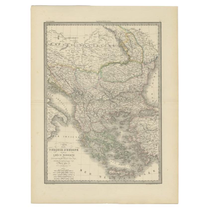
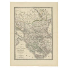
Antique Map of Turkey and Greece by Petri, c.1873
$141.77
£106.27
€120
CA$194.77
A$217.45
CHF 113.94
MX$2,661.76
NOK 1,447.02
SEK 1,364.36
DKK 913.48
Shipping
Retrieving quote...The 1stDibs Promise:
Authenticity Guarantee,
Money-Back Guarantee,
24-Hour Cancellation
About the Item
Antique map titled 'Europisch Turkije en Griekenland'. Old map depicting Turkey in Europe and Greece. This map originates from 'School-Atlas van alle Deelen der Aarde'.
Artists and Engravers: Published by O. Petri, Rotterdam.
Condition: Good, general age-related toning. Split on folding line, please study image carefully.
Date: c.1873
Overall size: 26.2 x 32.1 cm.
Image size: 21.1 x 28.6 cm.
We sell original antique maps to collectors, historians, educators and interior decorators all over the world. Our collection includes a wide range of authentic antique maps from the 16th to the 20th centuries. Buying and collecting antique maps is a tradition that goes back hundreds of years. Antique maps have proved a richly rewarding investment over the past decade, thanks to a growing appreciation of their unique historical appeal. Today the decorative qualities of antique maps are widely recognized by interior designers who appreciate their beauty and design flexibility. Depending on the individual map, presentation, and context, a rare or antique map can be modern, traditional, abstract, figurative, serious or whimsical. We offer a wide range of authentic antique maps for any budget.
- Dimensions:Height: 12.64 in (32.1 cm)Width: 10.32 in (26.2 cm)Depth: 0 in (0.01 mm)
- Materials and Techniques:
- Period:
- Date of Manufacture:c.1873
- Condition:Condition: Good, general age-related toning. Split on folding line, please study image carefully.
- Seller Location:Langweer, NL
- Reference Number:Seller: BG-06667-10'1stDibs: LU3054329312982
About the Seller
5.0
Recognized Seller
These prestigious sellers are industry leaders and represent the highest echelon for item quality and design.
Platinum Seller
Premium sellers with a 4.7+ rating and 24-hour response times
Established in 2009
1stDibs seller since 2017
2,511 sales on 1stDibs
Typical response time: <1 hour
- ShippingRetrieving quote...Shipping from: Langweer, Netherlands
- Return Policy
Authenticity Guarantee
In the unlikely event there’s an issue with an item’s authenticity, contact us within 1 year for a full refund. DetailsMoney-Back Guarantee
If your item is not as described, is damaged in transit, or does not arrive, contact us within 7 days for a full refund. Details24-Hour Cancellation
You have a 24-hour grace period in which to reconsider your purchase, with no questions asked.Vetted Professional Sellers
Our world-class sellers must adhere to strict standards for service and quality, maintaining the integrity of our listings.Price-Match Guarantee
If you find that a seller listed the same item for a lower price elsewhere, we’ll match it.Trusted Global Delivery
Our best-in-class carrier network provides specialized shipping options worldwide, including custom delivery.More From This Seller
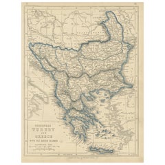
View AllAntique Map of Turkey and Greece, 1852
Located in Langweer, NL
Antique map titled 'Europisch Turkije en Griekenland'. Map of Turkey in Europe and Greece. This map originates from 'School-Atlas van alle deelen der Aar...
Category
Antique 19th Century Maps
Materials
Paper

$113 Sale Price
20% Off
Antique Map of Turkey and Greece, 1842
By Pierre M. Lapie
Located in Langweer, NL
Antique map titled 'Carte de la Turquie d'Europe et de la Grèce Moderne'. Map of Turkey and Greece. This map originates from 'Atlas universel de géographie ancienne et moderne (..)' ...
Category
Antique 19th Century Maps
Materials
Paper
$330 Sale Price
20% Off
Antique Map of Turkey in Europe by Wyld, '1845'
Located in Langweer, NL
Antique map titled 'Turkey in Europe'. Original antique map of Turkey in Europe. This map originates from 'An Atlas of the World, Comprehending S...
Category
Antique Mid-19th Century Maps
Materials
Paper

$189 Sale Price
20% Off
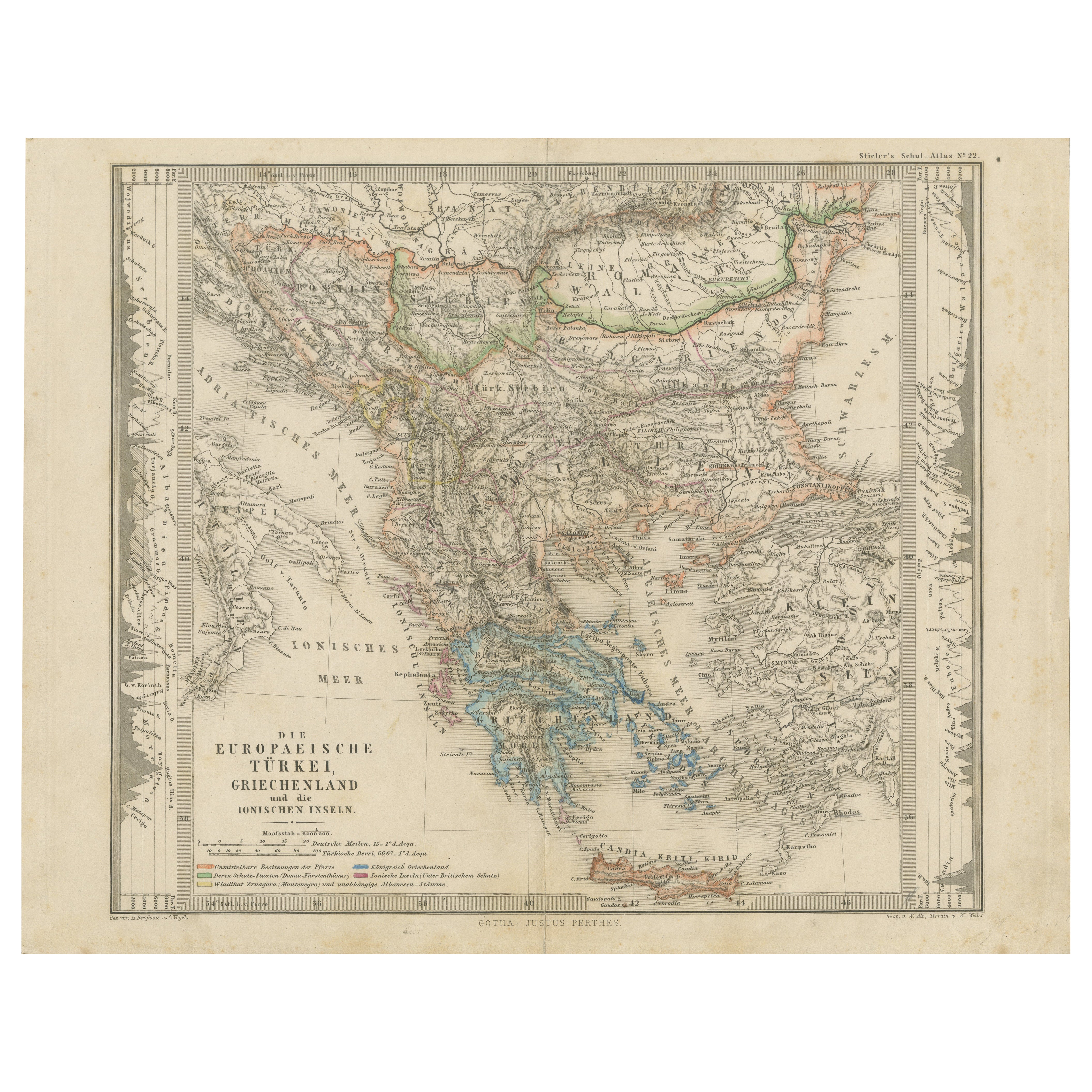
Small Antique Map of the European Turkey, Greece & Ionian Islands – c.1860
Located in Langweer, NL
Antique Map of the European Turkey, Greece & Ionian Islands – Stieler, c.1860
Original antique map titled *Die Europaeische Türkei, Griechenland und die ...
Category
Antique 1860s Maps
Materials
Paper

$113 Sale Price
20% Off
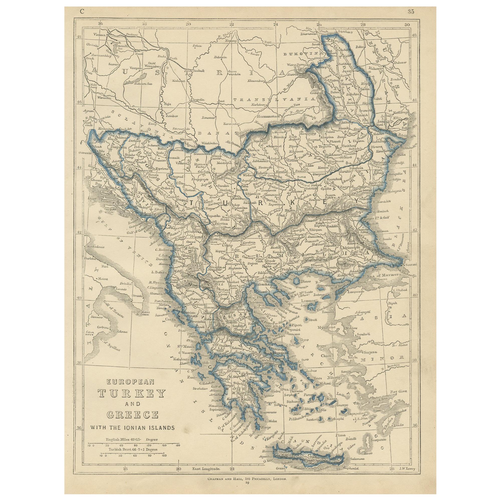
Antique Map of European Turkey and Greece by Lowry '1852'
Located in Langweer, NL
Antique map titled 'European Turkey and Greece with the Ionian Islands'. Original map of European Turkey and Greece. This map originates from 'Lowry's table Atlas constructed and eng...
Category
Antique Mid-19th Century Maps
Materials
Paper
$94 Sale Price
20% Off
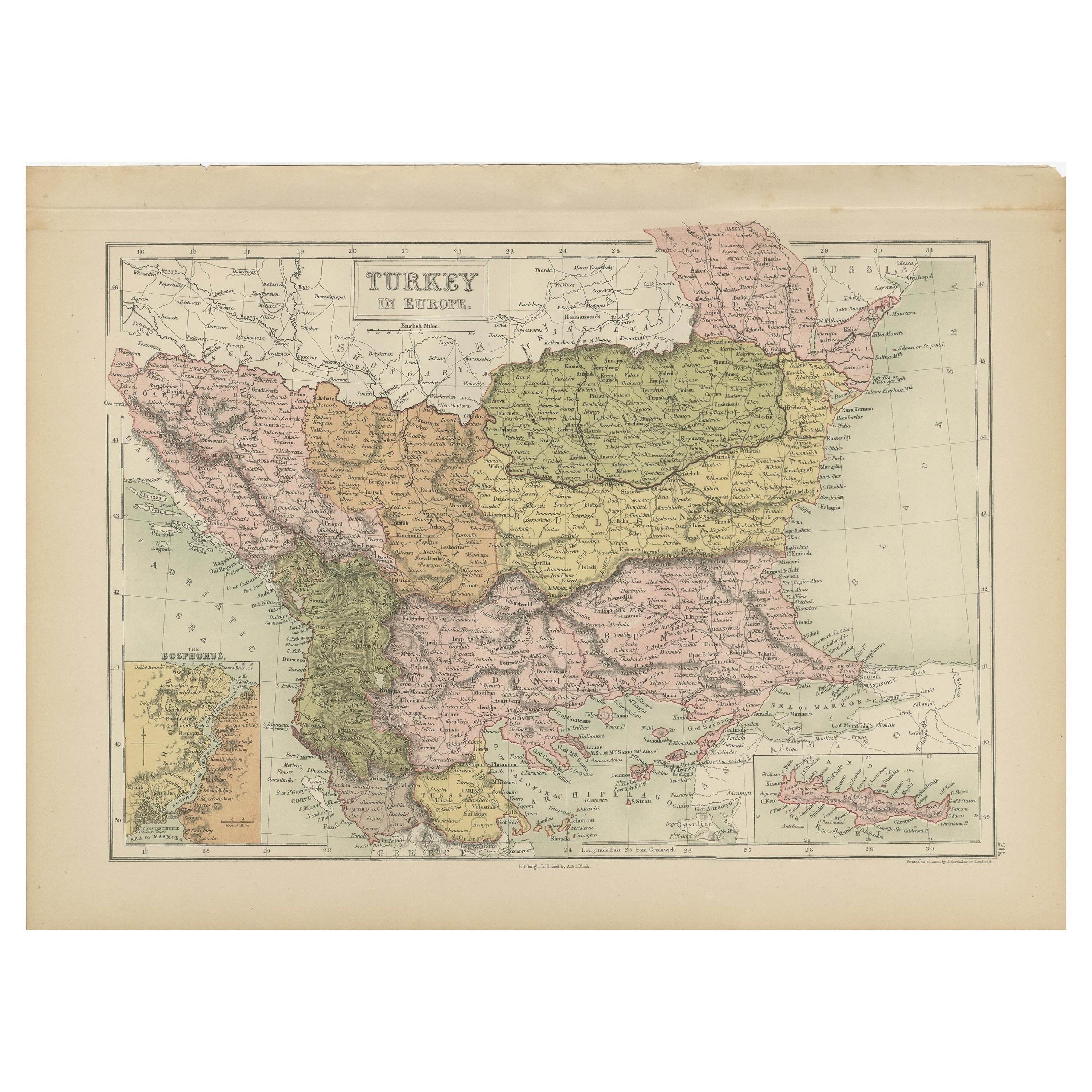
Antique Map of Turkey in Europe by A & C. Black, 1870
Located in Langweer, NL
Antique map titled 'Turkey in Europe'. Original antique map of Turkey in Europe with inset maps of the Bosporus and Crete or Candia. This map originates from ‘Black's General Atlas o...
Category
Antique Late 19th Century Maps
Materials
Paper
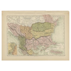
$165 Sale Price
20% Off
You May Also Like
Large Original Antique Map of Cyprus. 1894
Located in St Annes, Lancashire
Superb Antique map of Cyprus
Published Edward Stanford, Charing Cross, London 1894
Original colour
Good condition
Unframed.
Free shipping
Category
Antique 1890s English Maps
Materials
Paper

Map of Ancient Greece of Macedonia and... - Lithograph by Auguste Wahlen - 1844
Located in Roma, IT
Map of Ancient Greece of Macedonia and Thrace is a lithograph made by Auguste Wahlen in 1844.
Hand colored.
Good condition.
Bottom left is the original title "Carta della Grecia A...
Category
1840s Modern Figurative Prints
Materials
Lithograph

Original Antique Map of Ancient Greece, Achaia, Corinth, 1786
Located in St Annes, Lancashire
Great map of Ancient Greece. Showing the region of Thessaly, including Mount Olympus
Drawn by J.D. Barbie Du Bocage
Copper plate engraving by P.F Tardieu
Original hand color...
Category
Antique 1780s French Other Maps
Materials
Paper

Map of Eastern Roman Empire -Vintage Offset Print - Early 20th Century
Located in Roma, IT
This map of Eastern Roman Empire is a vintage offset print realized in the early 20th Century.
The state of preservation of the artwork is aged with dif...
Category
Early 20th Century Figurative Prints
Materials
Offset

Large Original Antique Map of The Greek Islands. 1894
Located in St Annes, Lancashire
Superb Antique map of The Greek Islands
Published Edward Stanford, Charing Cross, London 1894
Original colour
Good condition
Unframed.
Free shipping
Category
Antique 1890s English Maps
Materials
Paper

Greece, "Graeciae Antiquae"" A 17th Century Hand-colored Map by Sanson
By Nicolas Sanson
Located in Alamo, CA
This is an original 17th century hand colored copperplate engraved map of Greece entitled "Graeciae Antiquae Tabula Hanc Geographicam" by Nicolas d'Abbeville Sanson, engraved and pub...
Category
Antique Mid-17th Century French Maps
Materials
Paper

More Ways To Browse
Antique Maps Massachusetts
Guyana Antique Map
Peninsular War
Santa Cruz Island
Ukraine Antique Map
Antique Life Buoy
Antique Map Nova Scotia
Antique Map Of Argentina
Antique Maps Of Kansas
Cambodia Antique Map
Magellan Map
Map Ukraine
Mariners Chart
Papua New Guinea Antique Map
Bermuda Map
Scan Globe
Tunisia Antique Map
Antique Map New Orleans