Items Similar to Antique Map of Virginia & the Chesapeake Bay by Jacques-Nicolas Bellin, c. 1750


Want more images or videos?
Request additional images or videos from the seller
1 of 13
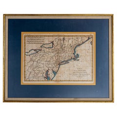
Antique Map of Virginia & the Chesapeake Bay by Jacques-Nicolas Bellin, c. 1750
$895
£674.83
€777.65
CA$1,241.61
A$1,391.21
CHF 724.18
MX$17,019.36
NOK 9,192.12
SEK 8,681.85
DKK 5,805.33
Shipping
Retrieving quote...The 1stDibs Promise:
Authenticity Guarantee,
Money-Back Guarantee,
24-Hour Cancellation
About the Item
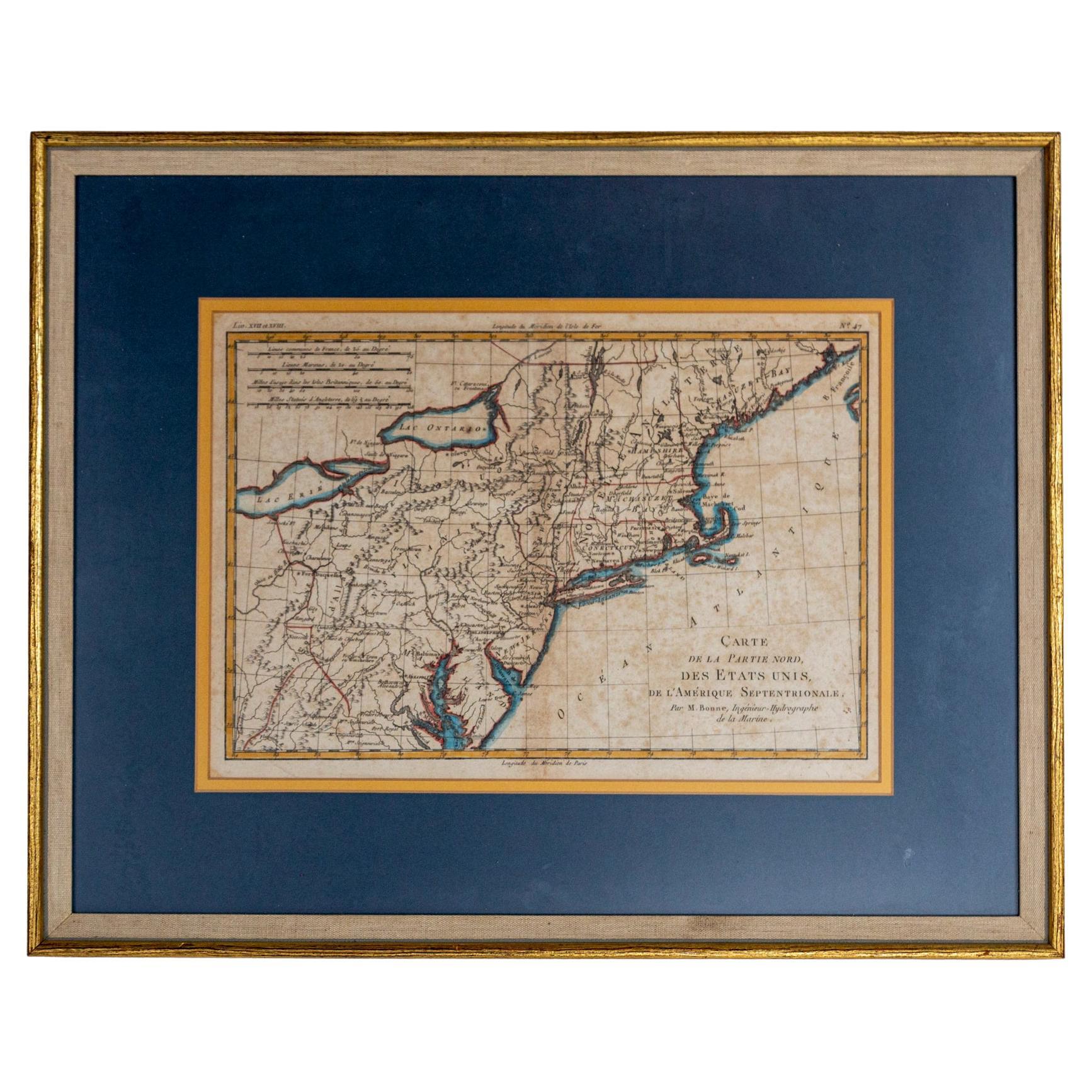
A fine antique 18th century French map of North America.
By Jacques-Nicolas Bellin.
On laid paper with polychrome highlights.
Depicting Virginia, the Chesapeake Bay, and the nearby states of Maryland, Pennsylvania, and New Jersey.
With a French inscription to the bottom right that reads:
"Carte de la Virginie, de la Baye Chesapeack, et Pays Voisins.
Pour servir à l'Histoire Générale des Voyages
Tirée des meilleures Cartes Angloises
Echelle
Lieues Communes de france
Pour éviter la confusion on a supprimé beaucoup de criques ou ruisseaux et les noms d'un grand nombre d'habitations particulieres de même que celui des Comtés."
Which translates as:
"Map of Virginia, Chesapeake Bay, and Neighboring Countries.
For use in the General History of Travel
Taken from the best English maps
Scale
Common Places of France
To avoid confusion, many creeks and streams have been removed, as well as the names of a large number of private dwellings, as well as those of the counties."
Together with a modern wooden frame.
Marked to the reverse with an label from Ludwig Katzenstein (a Maryland based framer).
Simply a wonderful antique map of Colonial America!
Date:
18th Century
Overall Condition:
It is in overall good, as-pictured, used estate condition.
Condition Details:
There are some folds in the paper and some light toning (mostly to the edges). Not observed outside the frame.
The frame is overall good used estate condtion with with some fine & light surface scratches and other signs of expected light wear consistent with age.
Maker:
Jacques-Nicolas Bellin
Marks:
With an old framer's label to the reverse.
Measurements:
Height: ca. 15 1/8 in.
Width: ca. 18 5/8 in.
Depth: ca. 1 1/8 in.
Sight Height: ca. 8 1/4 in.
Sight Width: ca. 12 1/4 in.
Items purchased from this dealer must delight you. Purchases may be returned for any reason for a period of 7 days.
- Creator:Jacques-Nicolas Bellin (Maker)
- Dimensions:Height: 15.13 in (38.44 cm)Width: 18.63 in (47.33 cm)Depth: 1.13 in (2.88 cm)
- Style:Baroque (Of the Period)
- Materials and Techniques:
- Place of Origin:
- Period:
- Date of Manufacture:18th Century
- Condition:Wear consistent with age and use. See description for condition details.
- Seller Location:Philadelphia, PA
- Reference Number:Seller: 3252025160136DSAINVCHMC251stDibs: LU1610244277642
Jacques-Nicolas Bellin
Jacques Nicolas Bellin (1703 –1772) was a French hydrographer (official cartographer) and a geographer. While still a teenager he became the chief cartographer to the French Navy and later to the king of France. Bellin created a large number of maps for Antoine François Prévost's (L'Abbe Prevost) 'Histoire Generale des Voyages', which was a 25 volume publication focused on 17th and 18th century exploration.It was published in French, Dutch and German. He also contributed maps and articles to the 35-volume Encyclopédie edited by Denis Diderot and Jean le Rond d'Alembert. He was part of the group called Philosophes, which included many of the great intellectuals of the Age of Enlightenment, including Voltaire, Rousseau and Montesquieu. Bellin died at Versailles in 1772.
About the Seller
5.0
Gold Seller
Premium sellers maintaining a 4.3+ rating and 24-hour response times
Established in 1996
1stDibs seller since 2015
534 sales on 1stDibs
Typical response time: 2 hours
- ShippingRetrieving quote...Shipping from: Philadelphia, PA
- Return Policy
Authenticity Guarantee
In the unlikely event there’s an issue with an item’s authenticity, contact us within 1 year for a full refund. DetailsMoney-Back Guarantee
If your item is not as described, is damaged in transit, or does not arrive, contact us within 7 days for a full refund. Details24-Hour Cancellation
You have a 24-hour grace period in which to reconsider your purchase, with no questions asked.Vetted Professional Sellers
Our world-class sellers must adhere to strict standards for service and quality, maintaining the integrity of our listings.Price-Match Guarantee
If you find that a seller listed the same item for a lower price elsewhere, we’ll match it.Trusted Global Delivery
Our best-in-class carrier network provides specialized shipping options worldwide, including custom delivery.More From This Seller
View AllAntique 18th Century Map of the Province of Pensilvania 'Pennsylvania State'
Located in Philadelphia, PA
A fine antique of the colony of Pennsylvania.
Noted at the top of the sheet as a 'Map of the province of Pensilvania'.
This undated and anonymous map is thought to be from the Gentleman's Magazine, London, circa 1775, although the general appearance could date it to the 1760's.
The southern boundary reflects the Mason-Dixon survey (1768), the western boundary is placed just west of Pittsburgh, and the northern boundary is not marked.
The map has a number of reference points that likely refer to companion text and appear to be connected to boundaries. The western and southern boundaries are marked Q, R, S, for example. A diagonal line runs from the Susquehanna R to the Lake Erie P. A broken line marked by many letters A, B, N, O, etc., appears in the east.
There are no latitude or longitude markings, blank verso.
Framed in a shaped contemporary gilt wooden frame and matted under a cream colored matte.
Bearing an old Graham Arader Gallery...
Category
Antique 18th Century British American Colonial Maps
Materials
Paper

New Map of North America from the Latest Discoveries, 1763
Located in Philadelphia, PA
A fine antique 18th century map of the North American seaboard.
Entitled "A New Map of North America from the Latest Discoveries 1763".
By the Cartographer/Engraver - John Spil...
Category
Antique Mid-18th Century English Georgian Maps
Materials
Paper

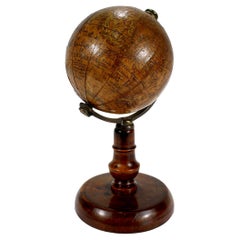
Antique 19th Century Miniature French Edition Globe by C. Abel-Klinger
By C. Abel-Klinger
Located in Philadelphia, PA
A fine antique French Edition miniature globe.
By C. Abel-Klinger.
On a turned wooden stand with an uncalibrated brass half meridian.
The globe is marked with an integral l...
Category
Antique 19th Century German Neoclassical Maps
Materials
Paper
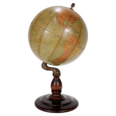
Antique Hammond's 6-Inch Terrestrial Globe on Stand
By C.S. Hammond & Co.
Located in Philadelphia, PA
Offered here for your consideration is, A fine antique 6-inch terrestrial globe.
Additional Details:
By C.S. Hammond & Co.
The globe likely dates from 1927 to 1930 due to the ...
Category
20th Century Unknown Art Deco Globes
Materials
Wood, Paper
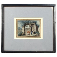
Antique Late 18th-Early 19th Century English Watercolor Painting of Ruins
Located in Philadelphia, PA
Offered here for your consideration is an antique watercolor painting on laid paper.
It depicts a cowherd with a cow and sheep at a water trough by ancient architectural ruins. Th...
Category
Antique Early 19th Century European Georgian Paintings
Materials
Paint, Paper
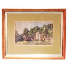
Antique 19th C English Watercolor View of Rievaulx Abbey
By William Turner
Located in Philadelphia, PA
A fine antique English watercolor landscape painting.
Depicting the ruins of Rievaulx Abbey in England circa July 1881.
Pencil signed to the lower right: Rievaulx Abbey July 1881
...
Category
Antique 1880s English Romantic Paintings
Materials
Paint, Paper
You May Also Like
1856 U.S. Coast Survey Map of Chesapeake Bay and Delaware Bay
Located in Colorado Springs, CO
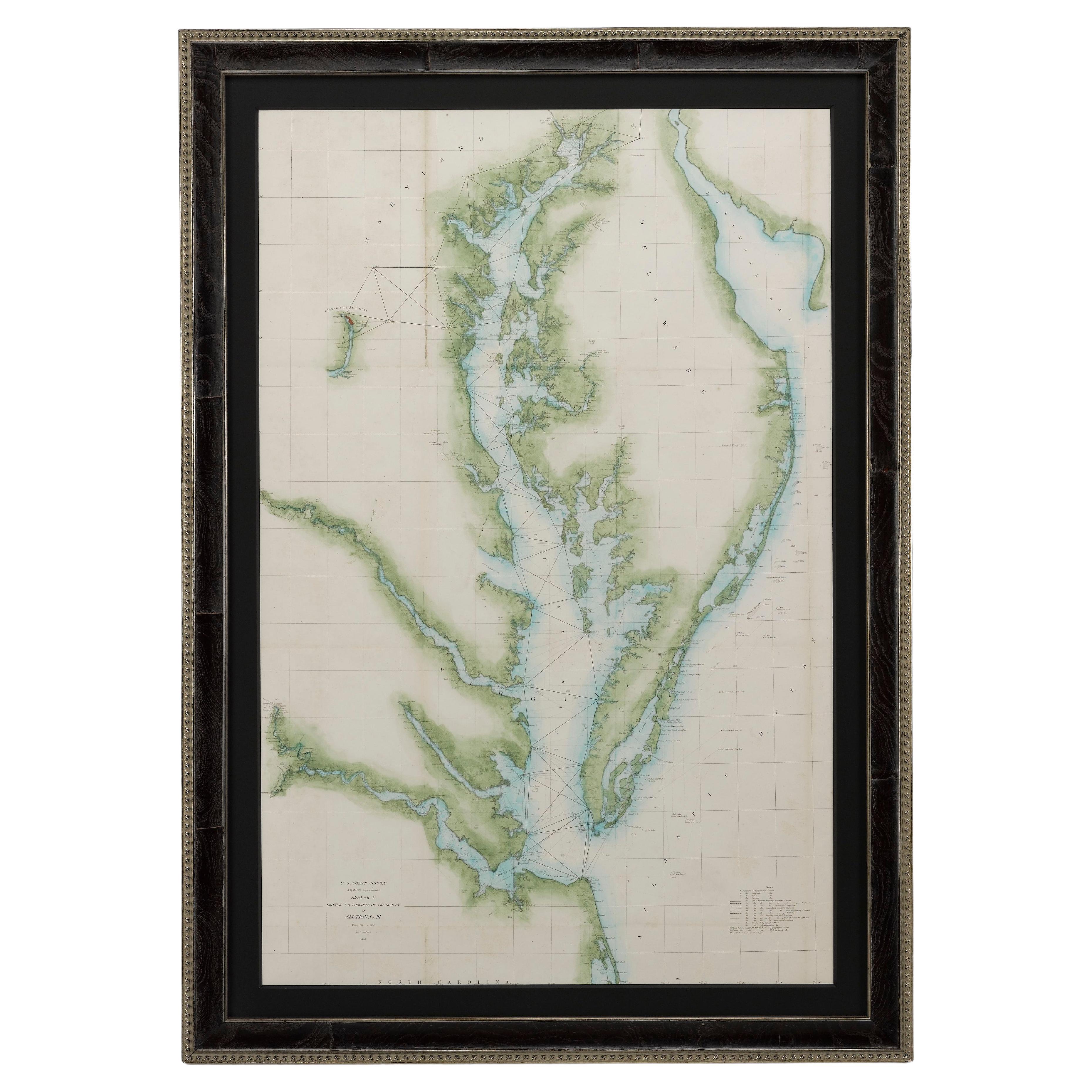
Presented is U.S. Coast Survey nautical chart or maritime map of Chesapeake Bay and Delaware Bay from 1856. The map depicts the region from Susquehanna, Maryland to the northern Outer Banks in North Carolina. It also shows from Richmond and Petersburg, Virginia to the Atlantic Ocean. The map is highly detailed with many cities and towns labeled throughout. Rivers, inlets, and bays are also labeled. Various charts illustrating more specific parts of the region are marked on the map using dotted lines. The lines form boxes, and the corresponding chart number and publication date are given. Extensive triangulation surveys were conducted the length of Chesapeake Bay and are illustrated here. Hampton Roads, Virginia is labeled, along with the James, York, and Rappahannock Rivers, which were all extensively surveyed.
The chart was published under the supervision of A. D. Bache, one of the most influential and prolific figures in the early history of the U.S. Coast Survey, for the 1856 Report of the Superintendent of the U.S. Coast Survey. Alexander Dallas Bache (1806-1867) was an American physicist, scientist, and surveyor. Bache served as the Superintendent of the U.S. Coast Survey from 1843 to 1865. Born in Philadelphia, Bache toured Europe and composed an important treatise on European Education. He also served as president of Philadelphia's Central High School and was a professor of natural history and chemistry at the University of Pennsylvania. Upon the death of Ferdinand Rudolph Hassler, Bache was appointed Superintendent of the United States Coast Survey.
The Office of the Coast Survey, founded in 1807 by President Thomas Jefferson and Secretary of Commerce Albert Gallatin...
Category
Antique 1850s American Maps
Materials
Paper

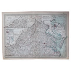
Original Antique Map of the American State of Virginia, 1903
Located in St Annes, Lancashire
Antique map of Virginia
Published By A & C Black. 1903
Original colour
Good condition
Unframed.
Free shipping
Category
Antique Early 1900s English Maps
Materials
Paper
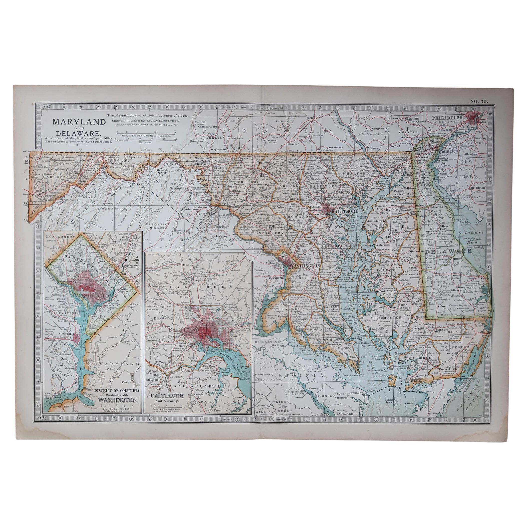
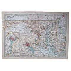
Original Antique Map of the American State of Maryland & Delaware, 1903
Located in St Annes, Lancashire
Antique map of Maryland And Delaware
Published By A & C Black. 1903
Original colour
Good condition
Unframed.
Free shipping
Category
Antique Early 1900s English Maps
Materials
Paper
1796 Map of North Carolina by John Reid
Located in Chapel Hill, NC
1796 Map of North Carolina by John Reid. A rare & important early map of the state based on the 1795 Lewis/Carey map for his "An American Atlas". Engraved by Benjamin Tanner. Old pur...
Category
Antique Late 18th Century American Prints
Materials
Paper

Hand-Colored French Map, Carte des Etats Unis, Par Bonne, Late 18th Century
By Rigobert Bonne
Located in Chappaqua, NY
Hand-colored French map, Carte de la Partie Nord, des Etats Unis, de l'Amérique Septentrionale, late 18th century. A French map of New England published at the end of the Revolutionary War...
Category
Antique Late 18th Century French Louis XVI Prints
Materials
Paper
1812 United States Map, by Pierre Tardieu, Antique French Map Depicting the U.S.
By Pierre François Tardieu
Located in Colorado Springs, CO
1812 "United States of Nth America -- Carte des Etats-Unis De L'Amerique Septentrionale" Two-Sheet Map by Tardieu
This attractive map, published in Paris in 1812, is one of the most rare large format maps from the period. It features a view of the East Coast of the U.S. from Maryland to just below South Carolina. Additionally, Ellicott’s plan for the City of Washington D.C. is included at the top right and an illustration of Niagara Falls is shown at the bottom right with a description in both French and English. This extremely detailed map not only depicts the mountainous regions of the southeastern U.S., but also includes names of regions, rivers, and towns.
Based on the first state of Arrowsmith’s 4-sheet map of the United States, this map is completely engraved by Tardieu in Paris and showcases high quality engravings. This detailed map of the recently independent United States includes one of the largest and earliest examples of the Ellicott plan of Washington DC.
The artist, Pierre François Tardieu (PF Tardieu) was a very well-known map engraver, geographer, and illustrator. Awarded a bronze medal by King Louis-Phillipe for the accuracy and beauty of his map-making, Tardieu produced many fine works including maps of Louisiana...
Category
Antique 1810s French Maps
Materials
Paper

More Ways To Browse
Antique Label Maker
Used Furniture North Bay
Antique Wooden Carts
Antique Wooden Trolley
18th Century Virginia
Jacques Le Meme
Folding Travel Picture Frame
Vintage Scandanavian Chairs
19th Century Red Glass
Antique French Console Table Tables
Silver Bowl Large
Antique French Silk
Down Couch
Used Lighter Art
Blue Edge Glass
Mahogany 1950s Furniture
Solid Mahogany Table
Dessert Glasses