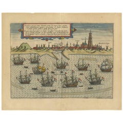
Items Similar to Antique Plan of Duinkerke or Dunkirk in France by Guicciardini, 1612

Want more images or videos?
Request additional images or videos from the seller
1 of 6
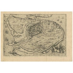
Antique Plan of Duinkerke or Dunkirk in France by Guicciardini, 1612
$220.38
$275.4820% Off
£163.32
£204.1520% Off
€184
€23020% Off
CA$300.87
CA$376.0820% Off
A$334.70
A$418.3820% Off
CHF 175.45
CHF 219.3220% Off
MX$4,089.97
MX$5,112.4620% Off
NOK 2,234.20
NOK 2,792.7420% Off
SEK 2,103.19
SEK 2,628.9820% Off
DKK 1,400.96
DKK 1,751.2020% Off
Shipping
Retrieving quote...The 1stDibs Promise:
Authenticity Guarantee,
Money-Back Guarantee,
24-Hour Cancellation
About the Item
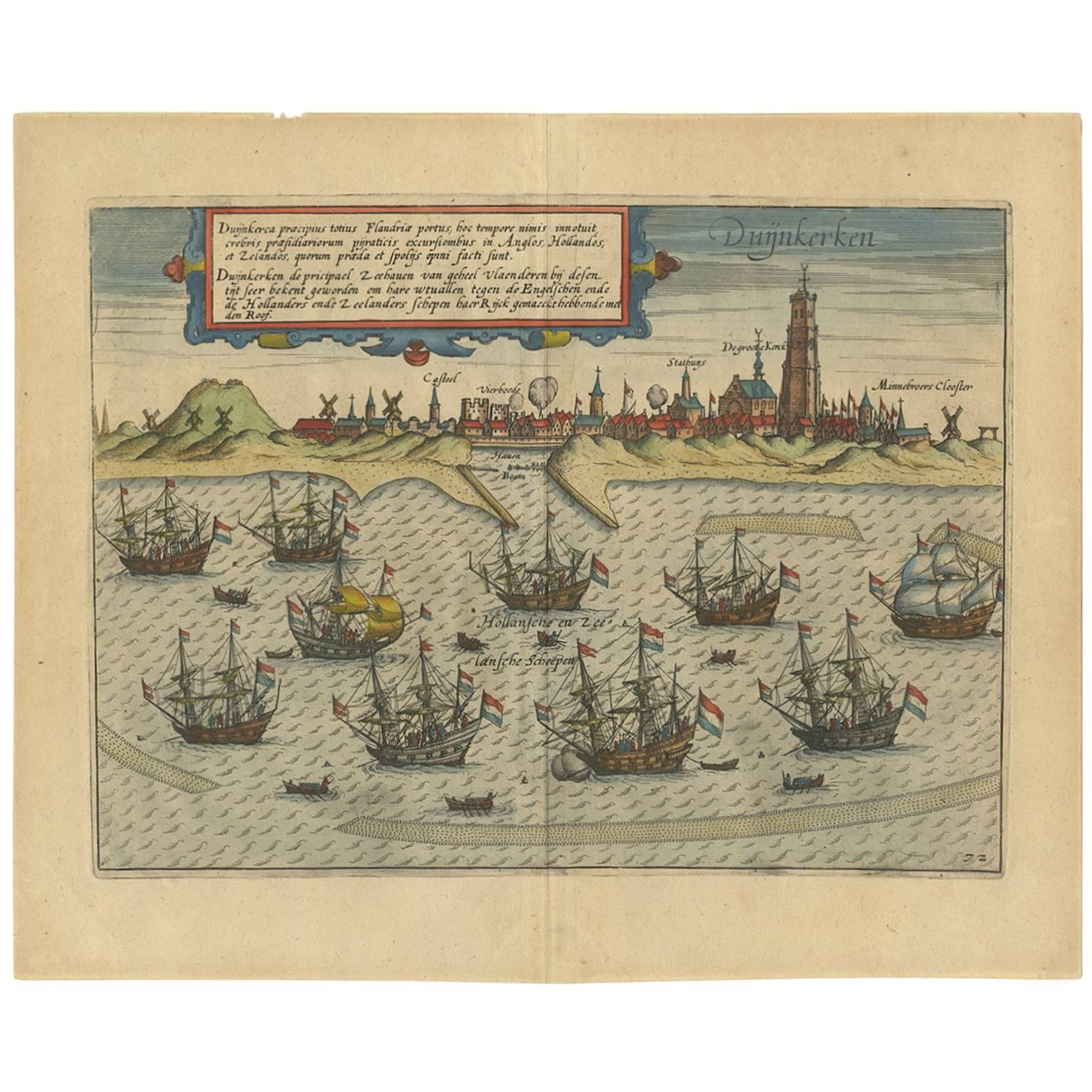
Antique map Duinkerke titled 'Duijnkerken'. Small plan of the city of Duinkerke/Dunkerque, France.
Artists and Engravers: Lodovico Guicciardini (1521-1589): an Italian merchant from aristocratic descent.
Condition: Good, age-related toning and some wear. Trimmed margins. Please study image carefully.
Date: 1612
Overall size: 38 x 22 cm.
We sell original antique maps to collectors, historians, educators and interior decorators all over the world. Our collection includes a wide range of authentic antique maps from the 16th to the 20th centuries. Buying and collecting antique maps is a tradition that goes back hundreds of years. Antique maps have proved a richly rewarding investment over the past decade, thanks to a growing appreciation of their unique historical appeal. Today the decorative qualities of antique maps are widely recognized by interior designers who appreciate their beauty and design flexibility. Depending on the individual map, presentation, and context, a rare or antique map can be modern, traditional, abstract, figurative, serious or whimsical. We offer a wide range of authentic antique maps for any budget.
- Dimensions:Height: 8.67 in (22 cm)Width: 14.97 in (38 cm)Depth: 0 in (0.01 mm)
- Materials and Techniques:
- Period:
- Date of Manufacture:1612
- Condition:Additions or alterations made to the original: Condition: Good, age-related toning and some wear. Trimmed margins. Please study image carefully. Condition: Good, age-related toning and some wear. Trimmed margins. Please study image carefully.
- Seller Location:Langweer, NL
- Reference Number:Seller: BGI-01464'1stDibs: LU3054329262582
About the Seller
5.0
Recognized Seller
These prestigious sellers are industry leaders and represent the highest echelon for item quality and design.
Platinum Seller
Premium sellers with a 4.7+ rating and 24-hour response times
Established in 2009
1stDibs seller since 2017
2,494 sales on 1stDibs
Typical response time: 1 hour
- ShippingRetrieving quote...Shipping from: Langweer, Netherlands
- Return Policy
Authenticity Guarantee
In the unlikely event there’s an issue with an item’s authenticity, contact us within 1 year for a full refund. DetailsMoney-Back Guarantee
If your item is not as described, is damaged in transit, or does not arrive, contact us within 7 days for a full refund. Details24-Hour Cancellation
You have a 24-hour grace period in which to reconsider your purchase, with no questions asked.Vetted Professional Sellers
Our world-class sellers must adhere to strict standards for service and quality, maintaining the integrity of our listings.Price-Match Guarantee
If you find that a seller listed the same item for a lower price elsewhere, we’ll match it.Trusted Global Delivery
Our best-in-class carrier network provides specialized shipping options worldwide, including custom delivery.More From This Seller
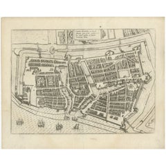
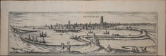
View AllAntique Print of the Town of Duinkerken ‘France’ by L. Guicciardini, 1613
Located in Langweer, NL
Beautiful bird's eye-view plan of the town of Duinkerken. From Ludovico Guicciardini.'s description of the Netherlands 'Beschrijvinghe van alle de Nederlanden anderssins ghenoemt Ned...
Category
Antique Early 17th Century Prints
Materials
Paper
$541 Sale Price
20% Off
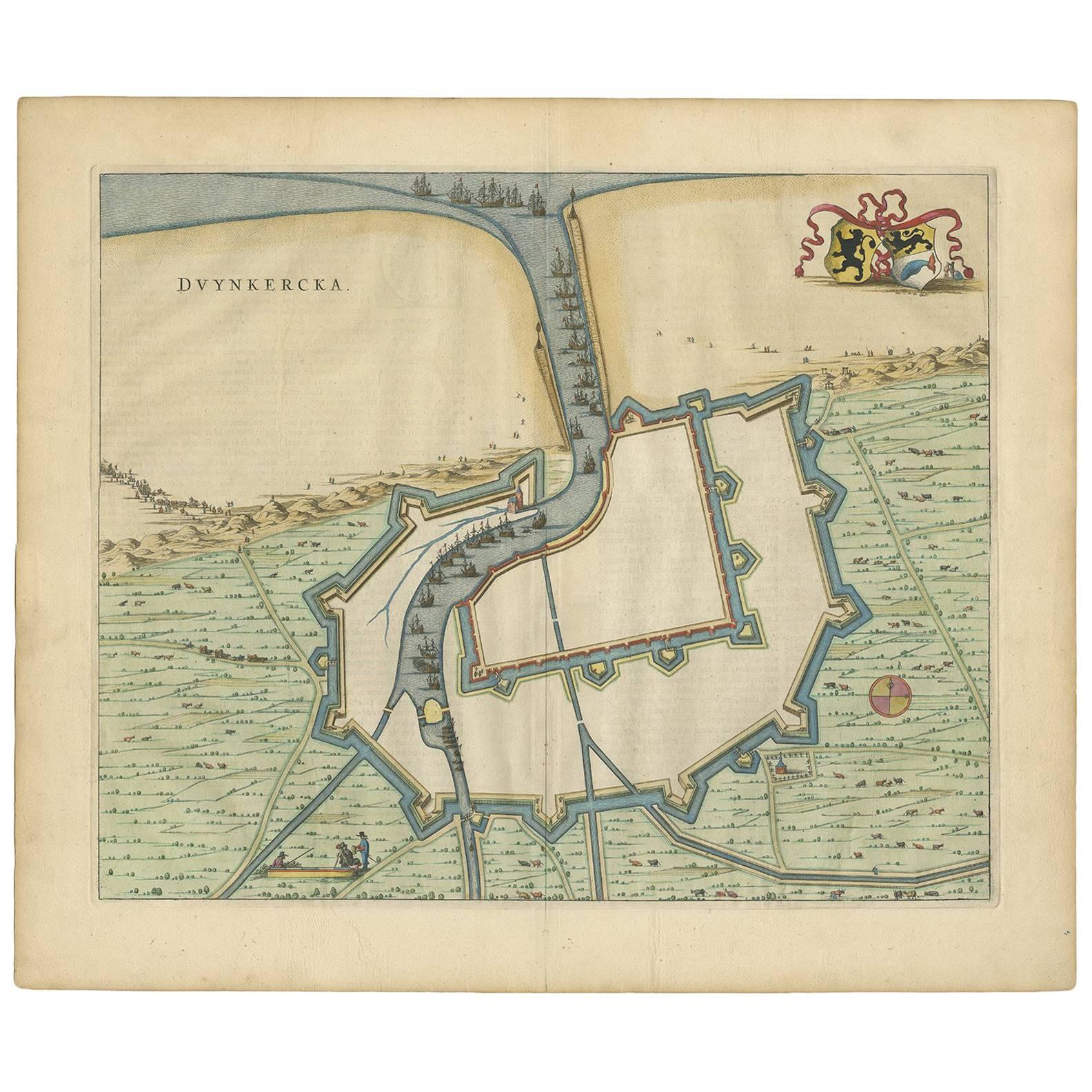
Antique Map of Dunkirk 'France' by J. Blaeu, 1649
Located in Langweer, NL
Antique map titled 'Duynkercka'. Published by J. Blaeu, 1649. Dutch text on verso.
Category
Antique Mid-17th Century Maps
Materials
Paper

$503 Sale Price
20% Off
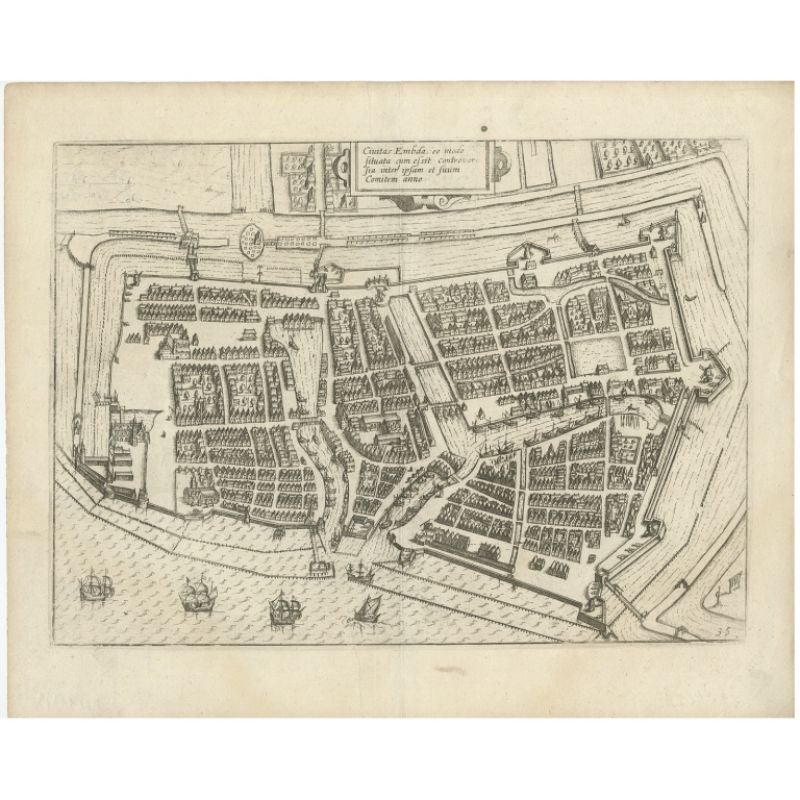
Antique Plan of Emden in Germany by Guicciardini, 1612
Located in Langweer, NL
Antique map Emden titled 'Civitas Embda, eo modo situata cum essit controversia inter ipsam et suum Comitem anno'. Small plan of the city of Emden, Germany, Also depicted is part of ...
Category
Antique 17th Century Maps
Materials
Paper
$364 Sale Price
20% Off
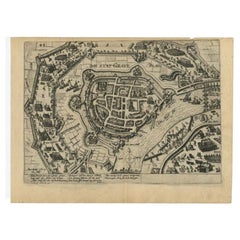
Antique Plan of Grave, The Netherlands, Showing the Siege of Grave in 1602
Located in Langweer, NL
Antique map titled 'Die Stat Grave' Bird's eye view plan of Grave, The Netherlands, Holland. Showing the siege of Grave in the year 1602 by Prince Maurits of The Netherlands. Source ...
Category
Antique 16th Century Maps
Materials
Paper
$421 Sale Price
20% Off
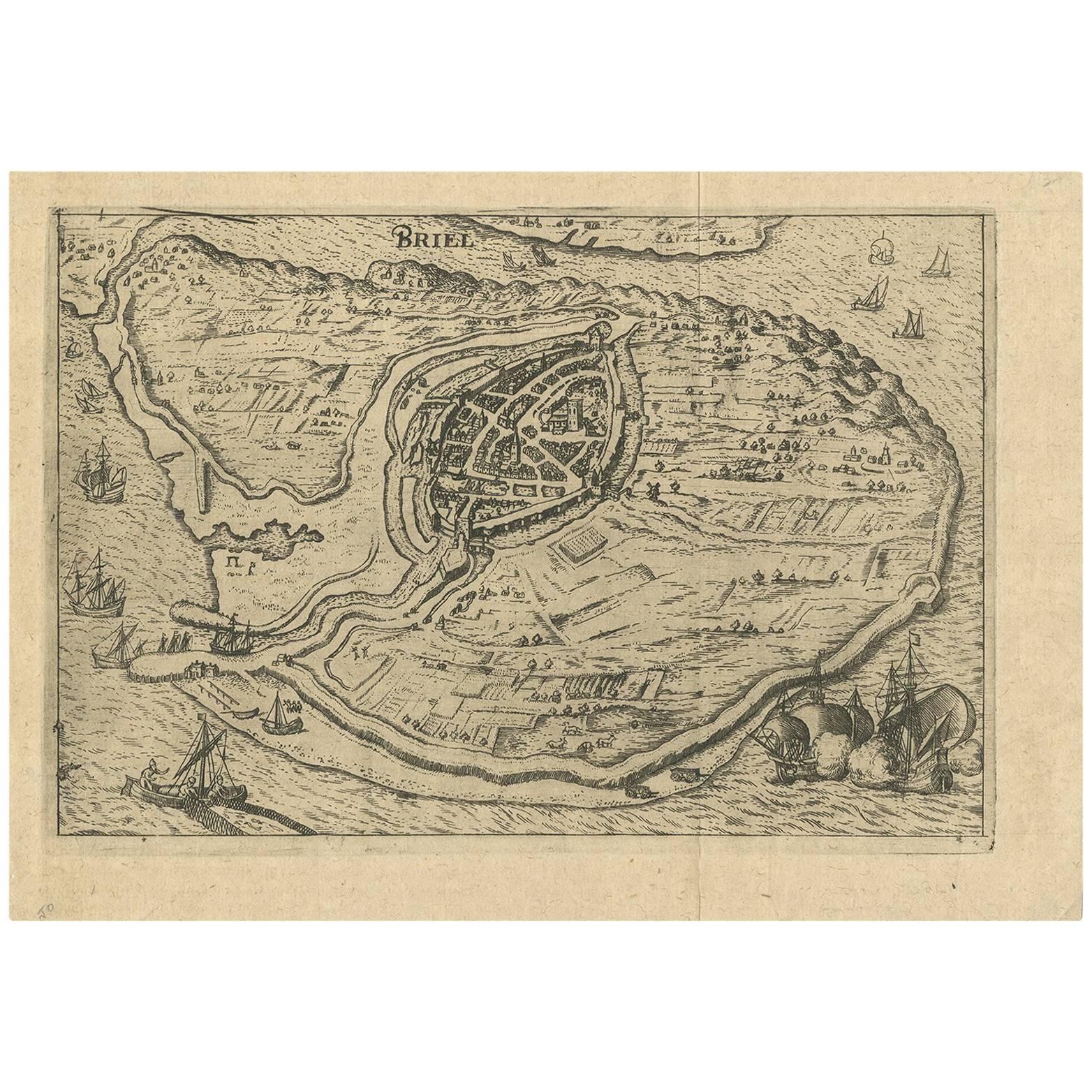
Antique Map of the City of Brielle 'The Netherlands' by L. Guicciardini, 1625
Located in Langweer, NL
Plan of Brielle, Briel, Den Briel in the Province of Zuid-Holland, The Netherlands, Holland. This map originates from the 1625 edition of 'Discrittione di tutti i Paesi Bassi', by L....
Category
Antique Early 17th Century Maps
Materials
Paper
$172 Sale Price
20% Off
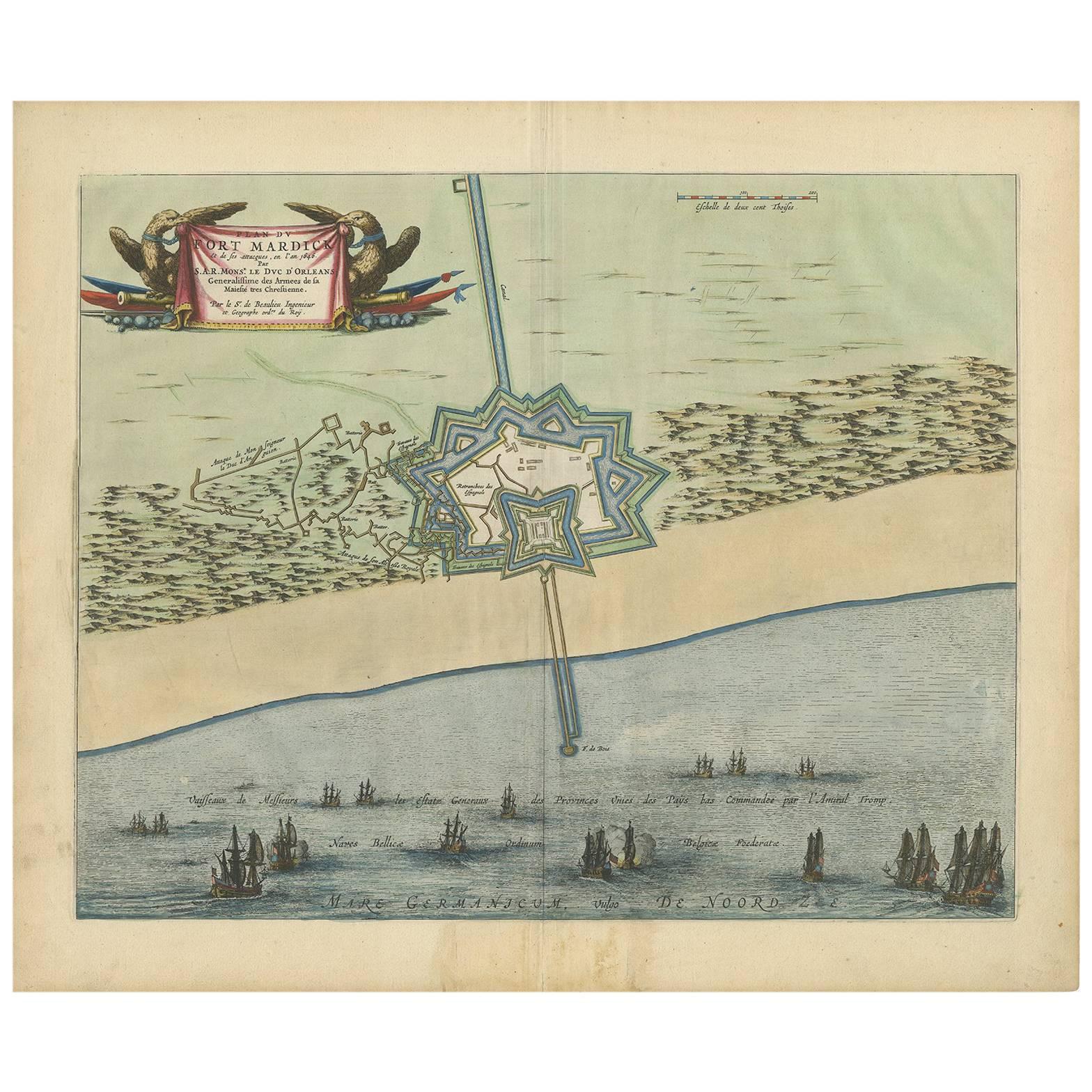
Antique Plan of Fort Mardyck Mardijk, France by S. Beaulieu, 1649
Located in Langweer, NL
Plan of Fort Mardyck (Fort Mardijk) and surroundings by Sébastian de Pontault Beaulieu. Mardyck is a former commune in the Nord department in northern France. It is an associated com...
Category
Antique Mid-17th Century Maps
Materials
Paper

$512 Sale Price
20% Off
You May Also Like
Dunkirk, Map from "Civitates Orbis Terrarum" - by F. Hogenberg - 1572/1617
By Franz Hogenberg
Located in Roma, IT
Braun G., Hogenberg F., Duynkercke or Dunkirk, from the collection Civitates Orbis Terrarum, Cologne, T. Graminaeus, 1572-1617.
Very fine B/W aquatint showing a view of the port and...
Category
16th Century Figurative Prints
Materials
Etching, Aquatint
1597 German Map of Alexandria by Georg Braun and Frans Hogenberg
By Georg Braun and Frans Hogenberg
Located in Chapel Hill, NC
1597 Map of Alexandria by Georg Braun and Frans Hogenberg, Germany. From "Civitas Orbis Terrarum", part 2, published in Cologne by Bertram Buchholz. Printed in 2 parts. Title: "Alexa...
Category
Antique 16th Century German Renaissance Maps
Materials
Paper

Map of the Netherlands - Etching by G. Braun and F. Hogenberg -Late 16th Century
By Franz Hogenberg
Located in Roma, IT
Map of the Netherlands is an original etching realized by George Braun and Franz Hogenberg, as part of the "Civitates Orbis Terrarum".
The “Civitates Orbis Terrarum” (Atlas of Citi...
Category
16th Century Figurative Prints
Materials
Etching

Map of Dordrecht - Etching by G. Braun/F. Hogenberg - Late 16th Century
Located in Roma, IT
Map od Dordrecht is an artwork realized by Braun and Hogemberg in the late 16th century.
Hand watercolored etching.
40x54 cm.
Good conditions.
Braun Hoghemberg (1541-1622) was a ...
Category
16th Century Old Masters Figurative Prints
Materials
Etching

1630 Pierre Petit map "Description du Gouvernement de la Capelle" Ric0010
Located in Norton, MA
1630 Pierre Petit map entitled
"Description du Gouvernement de la Capelle,"
Ric0010
Pierre Petit was the son of a minor provincial official in Montluçon. The town, in the Auver...
Category
Antique 17th Century Dutch Maps
Materials
Paper

Map of Nijmegen - Etching by G. Braun and F. Hogenberg - Late 16th Century
By Franz Hogenberg
Located in Roma, IT
This map of Noviomagvs is an original etching realized by Georg Braun and Franz Hogenberg as part of the famous series "Civitates Orbis Terrarum".
The state of preservation of the ...
Category
16th Century Figurative Prints
Materials
Etching

More Ways To Browse
Antique Map Of Yorkshire
Antique Map Vietnam
Antique Maps Massachusetts
Guyana Antique Map
Peninsular War
Santa Cruz Island
Ukraine Antique Map
Antique Life Buoy
Antique Map Nova Scotia
Antique Map Of Argentina
Antique Maps Of Kansas
Cambodia Antique Map
Magellan Map
Map Ukraine
Mariners Chart
Papua New Guinea Antique Map
Bermuda Map
Scan Globe