Items Similar to Beautiful Antique Map of Madagascar, The Comoros Islands & Reunion Island, 1667


Want more images or videos?
Request additional images or videos from the seller
1 of 7
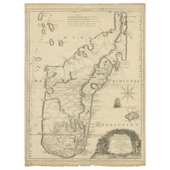
Beautiful Antique Map of Madagascar, The Comoros Islands & Reunion Island, 1667
$873
$1,091.2520% Off
£649.43
£811.7820% Off
€728
€91020% Off
CA$1,195.44
CA$1,494.3020% Off
A$1,329.17
A$1,661.4620% Off
CHF 694.02
CHF 867.5220% Off
MX$16,179.18
MX$20,223.9720% Off
NOK 8,855.35
NOK 11,069.1920% Off
SEK 8,297.04
SEK 10,371.3020% Off
DKK 5,541.86
DKK 6,927.3320% Off
Shipping
Retrieving quote...The 1stDibs Promise:
Authenticity Guarantee,
Money-Back Guarantee,
24-Hour Cancellation
About the Item
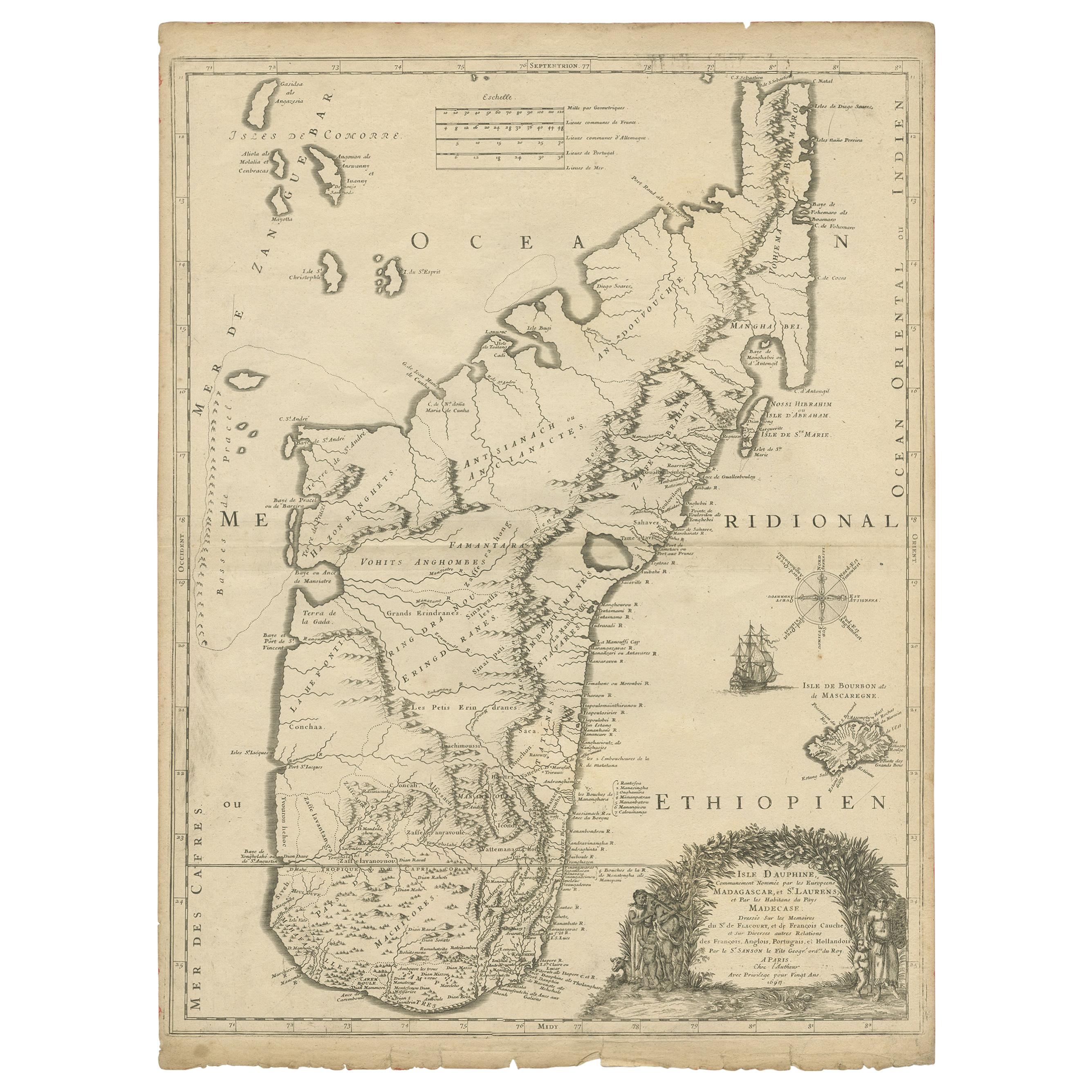
Antique map titled 'Isle d'Auphine, communement Nommée par les Europeens Madagascar, et St. Laurens, et par les Habitans du pays Madecase'.
Beautiful map of Madagascar, perhaps the finest and most up to date of its time, utilized by contemporary explorers. This map also depicts the Comoros Islands in the North West and the Reunion Island in the South East. With decorative title cartouche representing some natives, a compass rose and a vessel in the Indian Ocean.
Artists and engravers: Pierre Mariette II (1634-1716) was a French print dealer and Publisher. Guillaume Sanson (1633-1703) was a French cartographer and geographer at the court of the king of France, son of Nicolas Sanson.
- Dimensions:Height: 22.64 in (57.5 cm)Width: 18 in (45.7 cm)Depth: 0 in (0.02 mm)
- Materials and Techniques:
- Period:1660-1669
- Date of Manufacture:1667
- Condition:Repaired: Some tears have been repaired with tape on verso. Wear consistent with age and use. Condition: Good, general age-related toning. Some tears and tape on verso. Please study image carefully.
- Seller Location:Langweer, NL
- Reference Number:Seller: BG-07143 1stDibs: LU3054326956072
About the Seller
5.0
Recognized Seller
These prestigious sellers are industry leaders and represent the highest echelon for item quality and design.
Platinum Seller
Premium sellers with a 4.7+ rating and 24-hour response times
Established in 2009
1stDibs seller since 2017
2,510 sales on 1stDibs
Typical response time: <1 hour
- ShippingRetrieving quote...Shipping from: Langweer, Netherlands
- Return Policy
Authenticity Guarantee
In the unlikely event there’s an issue with an item’s authenticity, contact us within 1 year for a full refund. DetailsMoney-Back Guarantee
If your item is not as described, is damaged in transit, or does not arrive, contact us within 7 days for a full refund. Details24-Hour Cancellation
You have a 24-hour grace period in which to reconsider your purchase, with no questions asked.Vetted Professional Sellers
Our world-class sellers must adhere to strict standards for service and quality, maintaining the integrity of our listings.Price-Match Guarantee
If you find that a seller listed the same item for a lower price elsewhere, we’ll match it.Trusted Global Delivery
Our best-in-class carrier network provides specialized shipping options worldwide, including custom delivery.More From This Seller
View AllAntique Map of Madagascar by Mariette 'c.1670'
Located in Langweer, NL
Antique map titled 'Isle Dauphine communement nommée par les Europeens Madagascar, et St. Laurens (..)'. Original large-scale antique map of Madagascar...
Category
Antique Mid-17th Century Maps
Materials
Paper
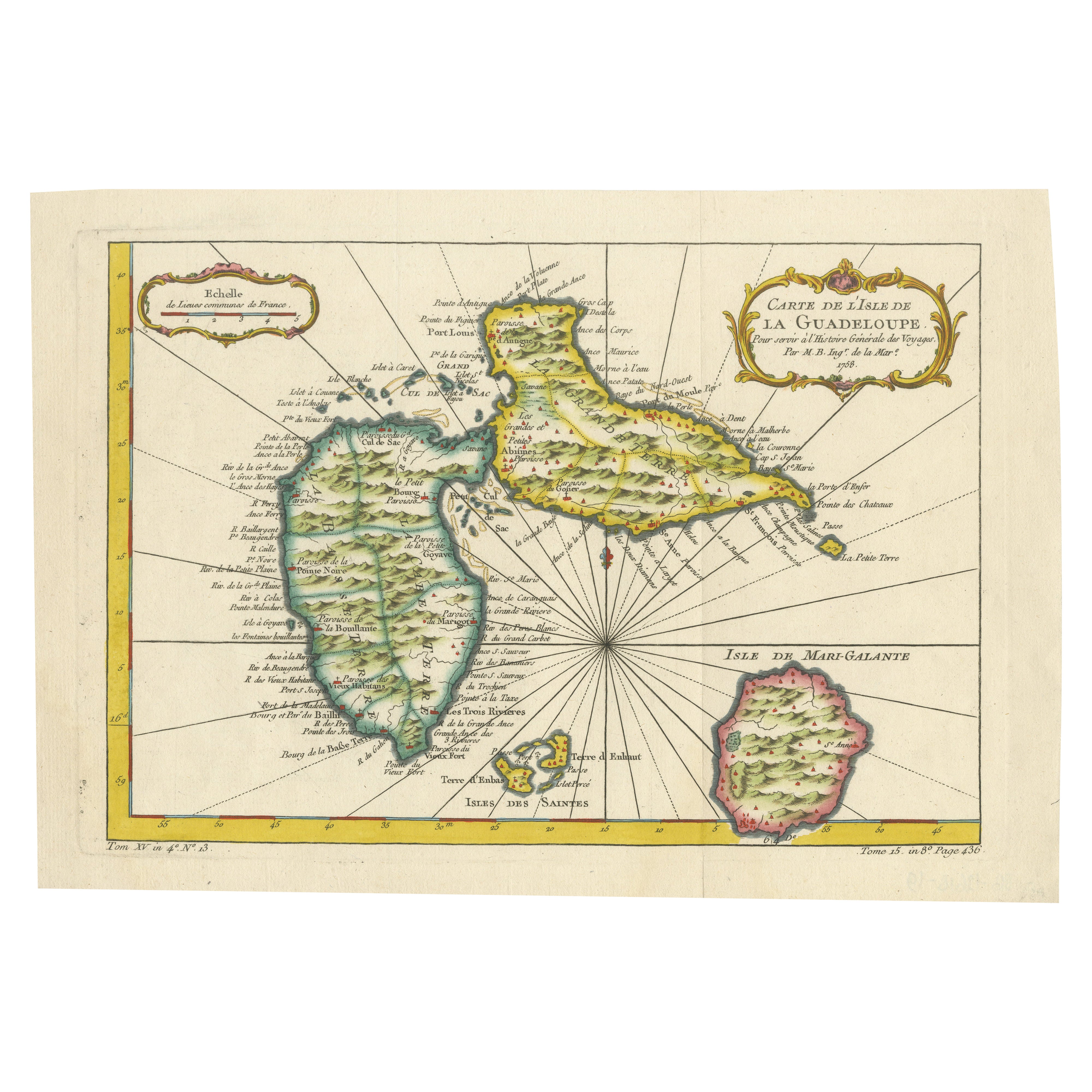
Antique Map of Guadeloupe, Island in the Caribbean, c.1757
Located in Langweer, NL
Antique map titled 'Carte de L'Isle de la Guadeloupe'.
A very decorative map of Guadeloupe in the Caribbean, adorned with rhumb lines, fleur-de-lys, and two decorative rococo-style...
Category
Antique 18th Century Maps
Materials
Paper

$633 Sale Price
20% Off
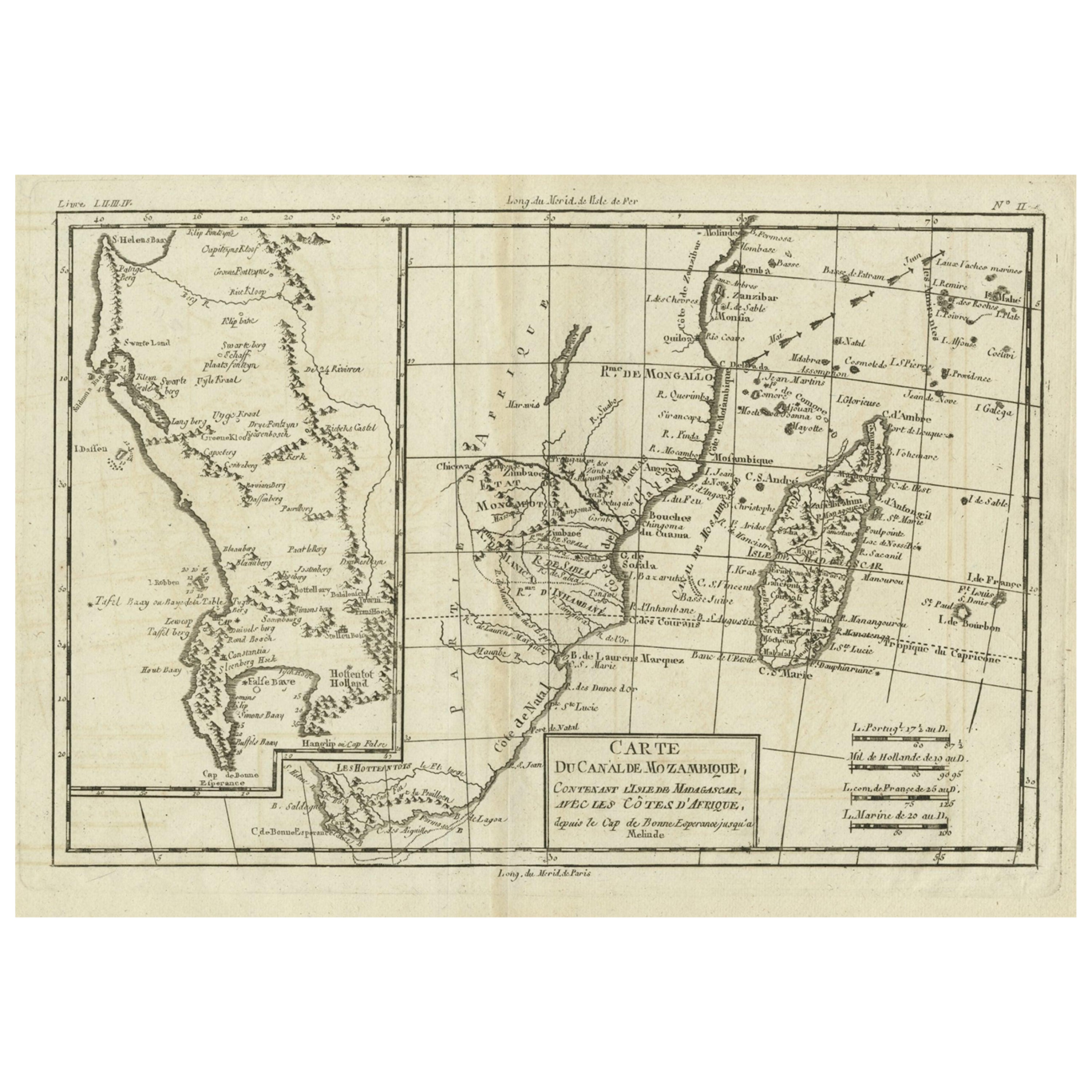
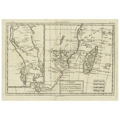
Antique Map of Mozambique Channel with Madagascar and Inset of Cape Region, 1780
Located in Langweer, NL
Antique map titled 'Carte du canal de Mosambique, contenant l'Isle de Madagascar avec les Cotes d'Afrique.' Map of Mozambique Channel, containing the Island of Madagascar with the coasts of Africa from Cape of Good Hope to Melinde. The inset map shows the Cape region in South Africa with False Bay, Robben Island etc. Source unknown, to be determined. Artists and Engravers: Rigobert Bonne (1727-1795 ) was one of the most important cartographers of the late 18th century. In 1773 he succeeded Jacques Bellin as Royal Cartographer to France in the office of the Hydrographer at the Depôt de la Marine. Working in his official capacity Bonne compiled some of the most detailed and accurate maps of the period. Bonne's work represents an important step in the evolution of the cartographic ideology away from the decorative work of the 17th and early 18th century towards a more detail oriented and practical aesthetic. With regard to the rendering of terrain Bonne maps...
Category
Antique 18th Century Maps
Materials
Paper
$422 Sale Price
20% Off
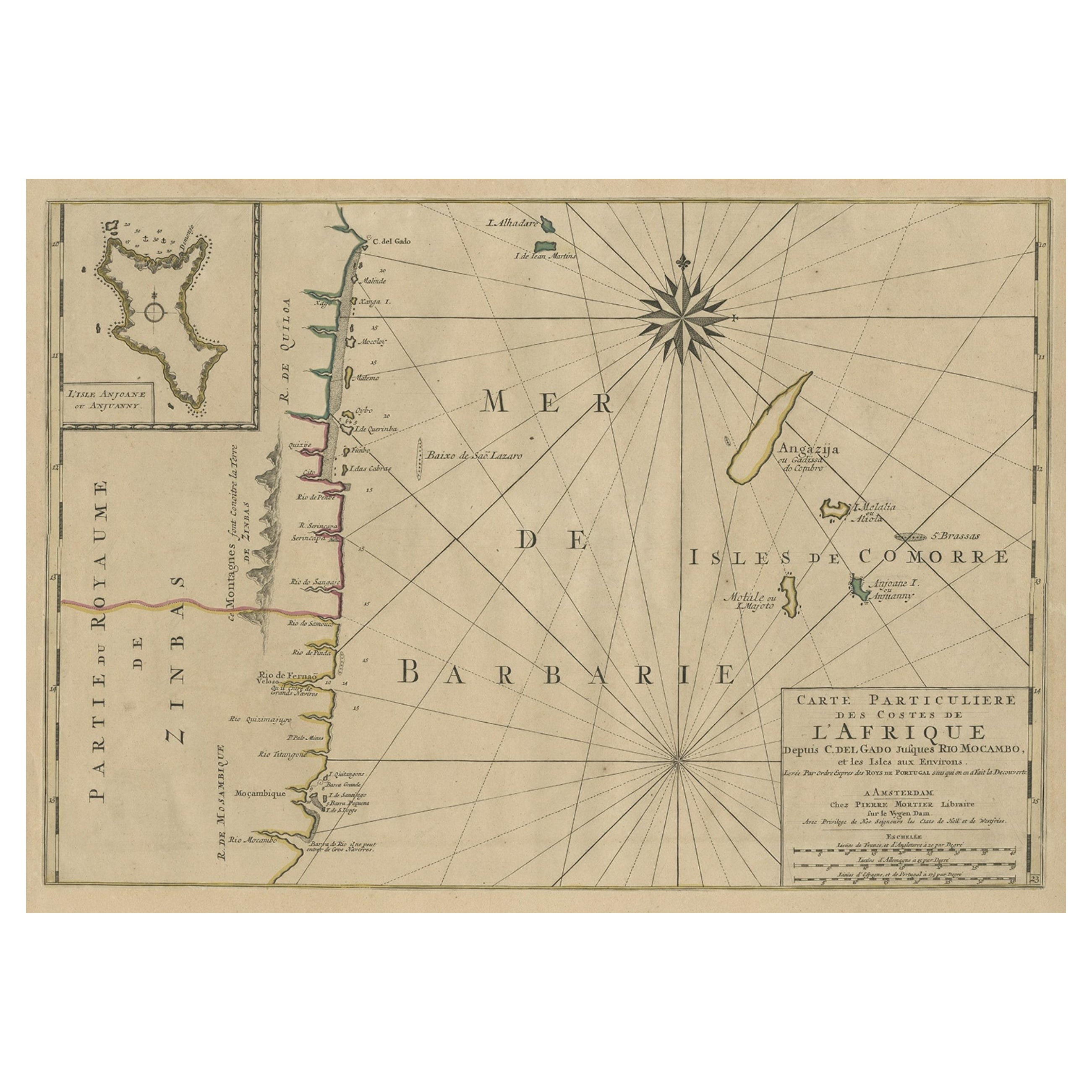
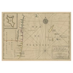
Map of the Mozambique and Tanzania Coast & Inset Map of Anjouan Island, ca.1700
Located in Langweer, NL
Antique map titled 'Carte particuliere des Costes de l'Afrique'.
Depicts the coasts of Mozambique and Tanzania. With an inset map of Anjouan Island.
Artists and engravers: Pub...
Category
Antique Early 1700s Maps
Materials
Paper
$613 Sale Price
20% Off
Antique Map of Madagascar by N. Sanson, circa 1680
By Nicolas Sanson
Located in Langweer, NL
Antique map titled 'Isle de Madagascar ou de St. Laurens. Tiree de Sanutu &c'. Antique map of Madagascar, first published by Sanson in 1657. Sanson n...
Category
Antique Late 17th Century Maps
Materials
Paper

$239 Sale Price
20% Off
1758 Bellin Map of Guadeloupe and Marie-Galante – Caribbean Islands
Located in Langweer, NL
Thank you for noting the correct date on the map. Here is your **updated plain text catalog listing**:
---
**Title (under 80 characters):**
1758 Bellin Map of Guadeloupe and Marie-Galante – Caribbean Islands
**Description:**
Original antique map titled *Carte de l’Isle de la Guadeloupe* by Jacques Nicolas Bellin, engraved for the *Histoire Générale des Voyages*, published in Paris in 1758.
This finely engraved copperplate map depicts the French Caribbean island of Guadeloupe, showing its distinctive butterfly-shaped division into Basse-Terre and Grande-Terre. The surrounding smaller islands include Marie-Galante (bottom right) and Les Saintes. The map details numerous place names, parishes, rivers, bays, mountains, and anchorages. A decorative rococo title cartouche graces the upper right corner, complemented by a scale bar cartouche in the upper left.
Jacques Nicolas Bellin (1703-1772) served as Hydrographer to the King and was one of the most prominent French cartographers of the 18th century, producing maps noted for their accuracy, elegance, and clarity. This map was created for the influential *Histoire Générale des Voyages* by Abbé Prévost.
Condition report:
Excellent condition. Strong and clean impression on fine laid paper with wide margins. Original hand coloring in outline and wash, highlighting coastlines and cartouches. Minor age toning at edges; verso blank.
Framing suggestion:
Frame with a classic gold or dark wood moulding and a neutral cream archival mat to emphasize the fine engraving and delicate color washes. Museum glass is recommended to preserve this 18th-century Caribbean map...
Category
Antique Mid-18th Century French Maps
Materials
Paper

You May Also Like
Large Original Antique Map of Madagascar. 1894
Located in St Annes, Lancashire
Superb Antique map of Madagascar
Published Edward Stanford, Charing Cross, London 1894
Original colour
Good condition
Unframed.
Free shipping
Category
Antique 1890s English Maps
Materials
Paper

West Coast of Africa, Guinea & Sierra Leone: An 18th Century Map by Bellin
By Jacques-Nicolas Bellin
Located in Alamo, CA
Jacques Bellin's copper-plate map entitled "Partie de la Coste de Guinee Dupuis la Riviere de Sierra Leona Jusquau Cap das Palmas", depicting the coast of Guinea and Sierra Leone in ...
Category
Antique Mid-18th Century French Maps
Materials
Paper

St. Christophe 'St. Kitts' Island: An 18th Century Hand-colored Map by Bellin
By Jacques-Nicolas Bellin
Located in Alamo, CA
Jacques Bellin's copper-plate map of the Caribbean island of Saint Kitts entitled "Carte De De l'Isle St. Christophe Pour servir á l'Histoire Genle. des V...
Category
Antique Mid-18th Century French Maps
Materials
Paper

1654 Joan Blaeu Map the Sutherland, Scotland, Entitled "Southerlandia, "Ric0007
Located in Norton, MA
1654 Joan Blaeu map of the
Sutherland, Scotland, entitled
"Southerlandia,"
Hand Colored
Ric0007
Description:
Lovely map centered on Sedan and D...
Category
Antique 17th Century Dutch Maps
Materials
Paper

Original Antique Map of South America. C.1780
Located in St Annes, Lancashire
Great map of South America
Copper-plate engraving
Published C.1780
Two small worm holes to left side of map
Unframed.
Category
Antique Early 1800s English Georgian Maps
Materials
Paper

Captain Cook's Exploration of Tahiti 18th C. Hand-Colored Map by Bellin
By Jacques-Nicolas Bellin
Located in Alamo, CA
This beautiful 18th century hand-colored copper plate engraved map is entitled "Carte de l'Isle de Taiti, par le Lieutenant J. Cook" was created by Jacques Nicolas Bellin and publish...
Category
Antique Mid-18th Century French Maps
Materials
Paper

More Ways To Browse
Map Of Madagascar
Ottoman Map
Antique Map Of Korea
Maps South East Asia
Antique Furniture Kansas City
Antique Great Lakes Map
Arnold And Son
Indianapolis Antique Furniture
Antique Map Of Jerusalem
Antique Maps Of Sicily
Antique Celestial Maps
Antique Compass Maritime Compasses
Bengal Map
J C Walker Map
Map Of Ancient Greece
Ptolemy Map
Antique Marine Compass
Map Of Jerusalem