Items Similar to Bhor Ghat a Mountain Passage Between Karjat & Khandala, Maharashtra, India, 1883

Want more images or videos?
Request additional images or videos from the seller
1 of 6
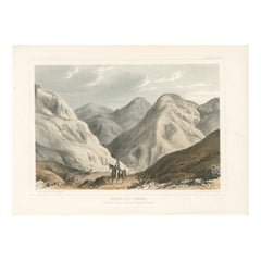
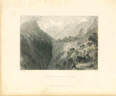
Bhor Ghat a Mountain Passage Between Karjat & Khandala, Maharashtra, India, 1883
$115.29
$144.1220% Off
£84.91
£106.1420% Off
€96
€12020% Off
CA$156.85
CA$196.0620% Off
A$174.29
A$217.8720% Off
CHF 91.33
CHF 114.1720% Off
MX$2,137.41
MX$2,671.7620% Off
NOK 1,164.89
NOK 1,456.1120% Off
SEK 1,095.88
SEK 1,369.8520% Off
DKK 730.83
DKK 913.5420% Off
Shipping
Retrieving quote...The 1stDibs Promise:
Authenticity Guarantee,
Money-Back Guarantee,
24-Hour Cancellation
About the Item
Plate: 'Bhor Ghat, 'Rampe du Chemin de fer, pres de Khandala'. This plate shows the Bhor Ghat a mountain passage located between Karjat and Khandala in Maharashtra, India. This plate originates from: 'Nouvelle Geographie Universelle. La Terre et les Hommes.', by Elisee Reclus, published 1875-1894 in Paris by Librairie hachette et Cie. This is a reknown 19 volume work on world geographie. This plate is from vol. VIII on 'L'Inde et L'Indo-Chine.', published 1883.
Artists and Engravers: Author: Elisee Reclus (1830-1905), also known as Jacques Elisee Reclus, was a renowned French geographer, writer and anarchist. He produced his 19-volume masterwork La Nouvelle Geographie universelle, la terre et les hommes ('Universal Geography.'), over a period of nearly 20 years (1875-1894). In 1892 he was awarded the prestigious Gold Medal of the Paris Geographical Society for this work, despite his having been banished from France because of his political activism. This plate engraved by Hildibrand after Taylor after M. Frith.
- Dimensions:Height: 7.09 in (18 cm)Width: 10.44 in (26.5 cm)Depth: 0 in (0.02 mm)
- Materials and Techniques:
- Period:
- Date of Manufacture:1883
- Condition:Condition: Good. General age related toning; Occasional light foxing. Please study scan carefully.
- Seller Location:Langweer, NL
- Reference Number:Seller: PCT-278791stDibs: LU3054327454002
About the Seller
5.0
Recognized Seller
These prestigious sellers are industry leaders and represent the highest echelon for item quality and design.
Platinum Seller
Premium sellers with a 4.7+ rating and 24-hour response times
Established in 2009
1stDibs seller since 2017
2,494 sales on 1stDibs
Typical response time: 1 hour
- ShippingRetrieving quote...Shipping from: Langweer, Netherlands
- Return Policy
Authenticity Guarantee
In the unlikely event there’s an issue with an item’s authenticity, contact us within 1 year for a full refund. DetailsMoney-Back Guarantee
If your item is not as described, is damaged in transit, or does not arrive, contact us within 7 days for a full refund. Details24-Hour Cancellation
You have a 24-hour grace period in which to reconsider your purchase, with no questions asked.Vetted Professional Sellers
Our world-class sellers must adhere to strict standards for service and quality, maintaining the integrity of our listings.Price-Match Guarantee
If you find that a seller listed the same item for a lower price elsewhere, we’ll match it.Trusted Global Delivery
Our best-in-class carrier network provides specialized shipping options worldwide, including custom delivery.More From This Seller
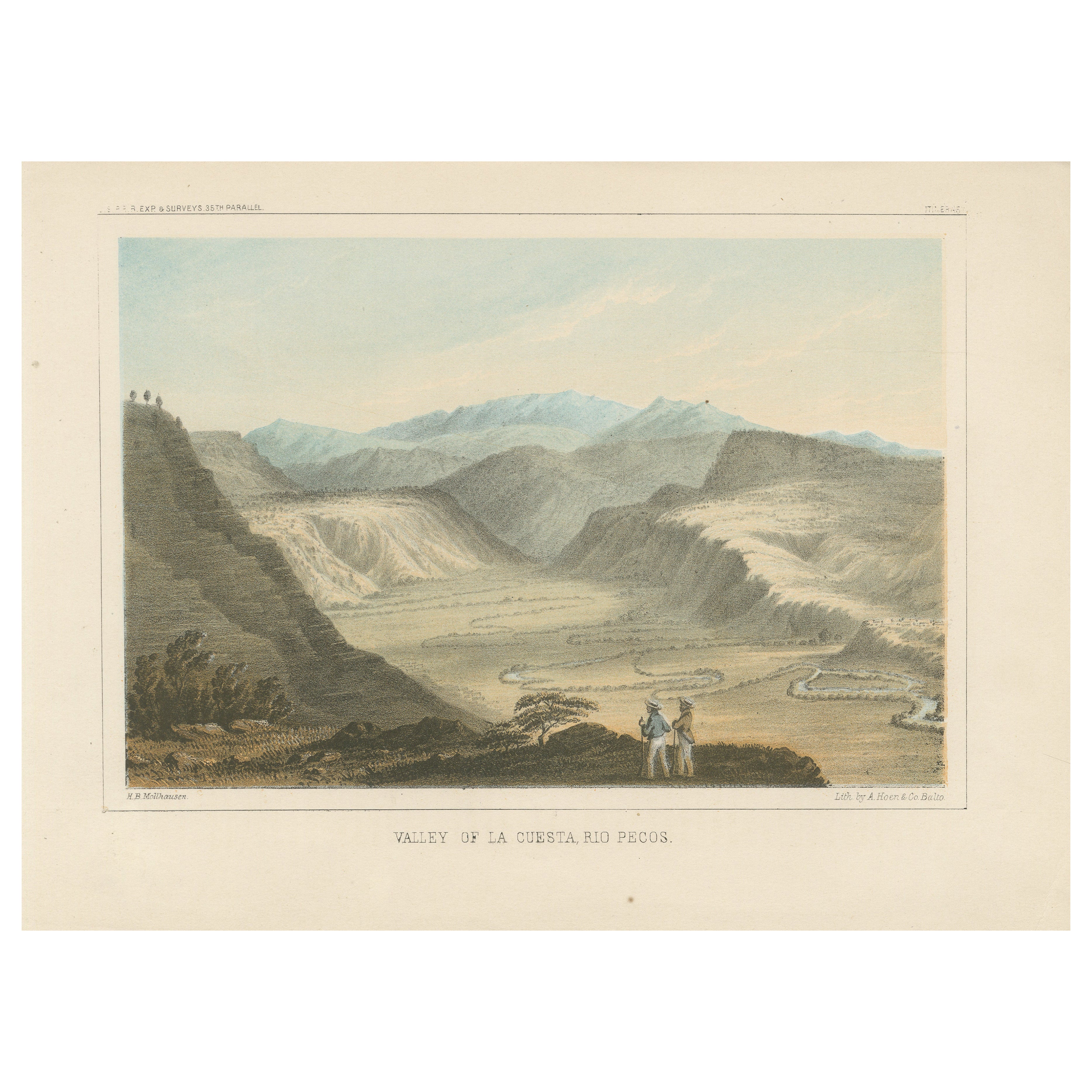
View AllSpectacular View of Valley La Cuesta, Rio Pecos - 19th Century Lithograph
Located in Langweer, NL
Title: Spectacular View of Valley La Cuesta, Rio Pecos - 19th Century Lithograph
Description: This breathtaking lithograph captures the scenic beauty of the Valley of La Cuesta al...
Category
Antique 1850s Prints
Materials
Paper

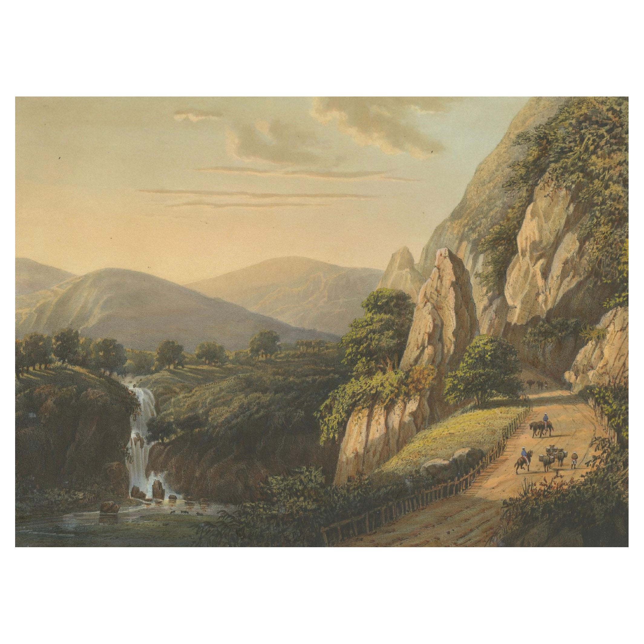
Mountain Road and Waterfall in the Tengger Range – Java Lithograph, circa 1872
Located in Langweer, NL
Mountain Road and Waterfall in the Tengger Range – Java Lithograph, Published 1872
This powerful and richly detailed chromolithograph captures a dramatic stretch of road through the...
Category
Antique 1870s Prints
Materials
Paper

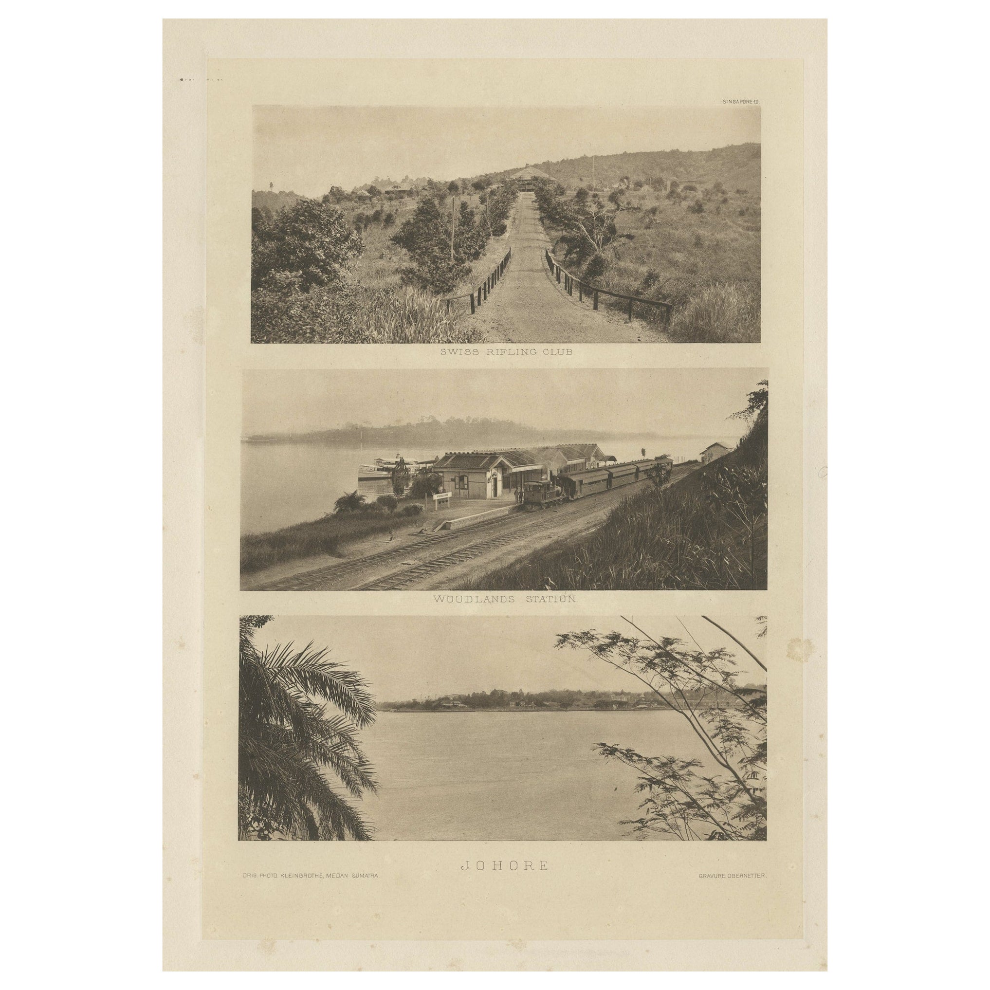
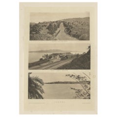
Rare Heliogravures of Singapore and Johore, Published in 1907
Located in Langweer, NL
Rare views of early Singapore and Johore in 1907.
1) Swiss Rifling Club
2) Woodlands Station
3) Johore
These heliogravures are on one leaf from the extremely rare boxed Ma...
Category
Antique Early 1900s Prints
Materials
Paper
$624 Sale Price
20% Off
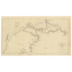
Gregory's 1861 Expedition into the North West of Australia, 1862
Located in Langweer, NL
The map represents the route taken during F.T. Gregory's 1861 North West Australian Expedition.
This exploration was a significant journey that took place over the Pilbara region, starting from the Ashburton River and extending to the Dampier Archipelago and the De Grey...
Category
Antique 1860s Prints
Materials
Paper
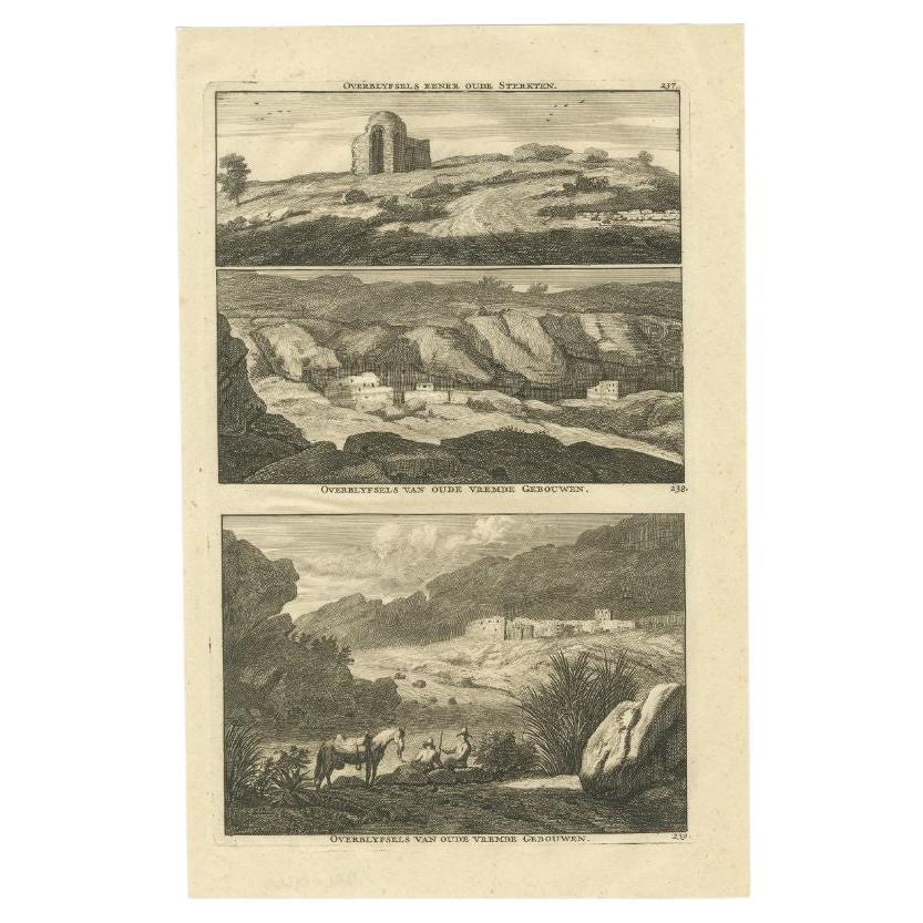
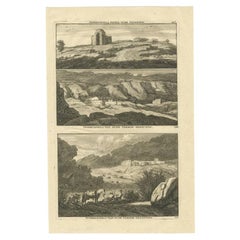
Old and Rare Original Engravings of Ruins in India, 1711
Located in Langweer, NL
Antique print titled 'Overblyfsels eener oude Sterkten - Overblyfsels van oude vremde Gebouwen - Overblyfsels van oude vremde Gebouwen'. View of various ruins in Jaron, India. This p...
Category
Antique 18th Century Prints
Materials
Paper
$134 Sale Price
20% Off
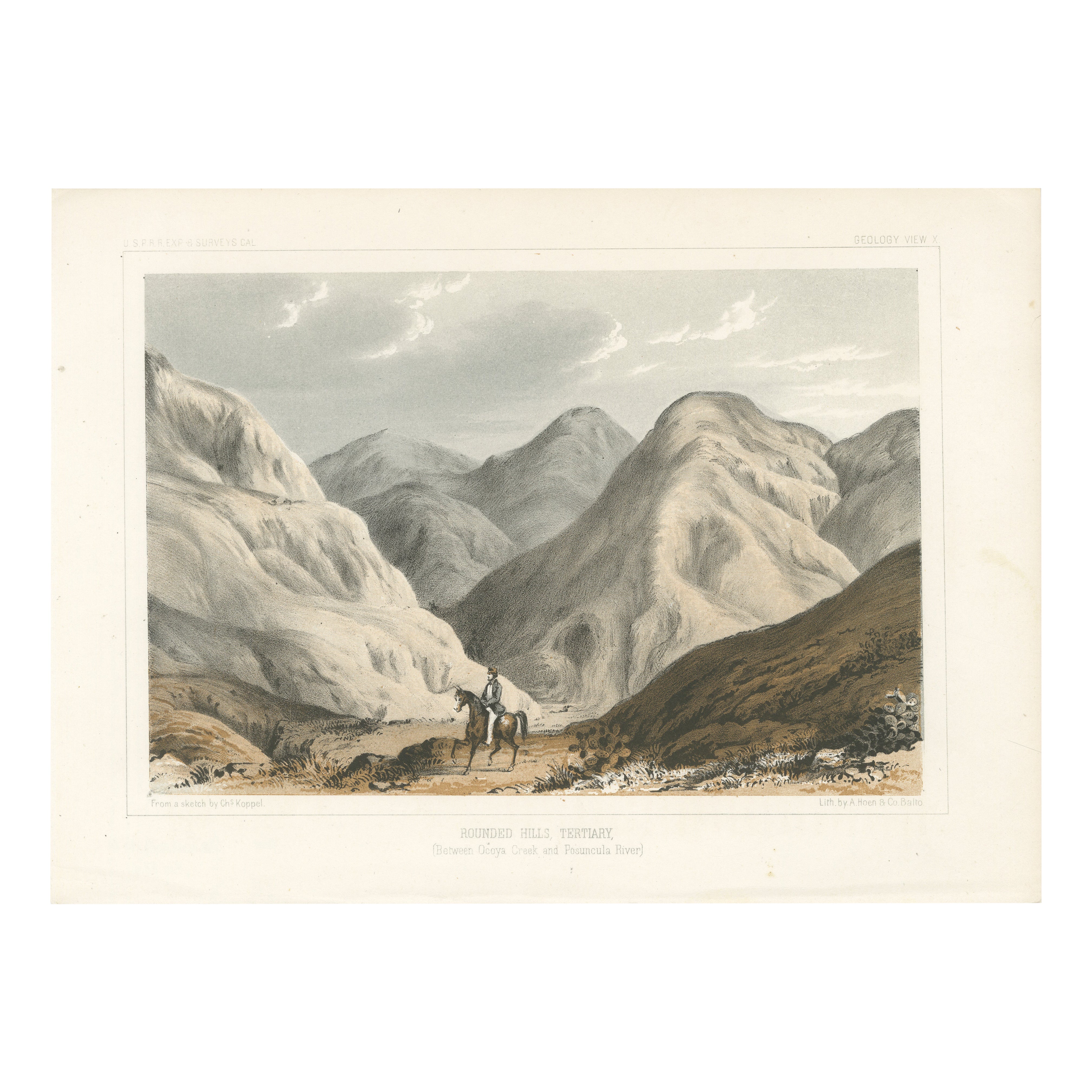
Rounded Hills, Tertiary - Between Ocoya Creek and Posuncula River, Litho of 1856
Located in Langweer, NL
Title: Rounded Hills, Tertiary - Lithograph from Between Ocoya Creek and Posuncula River, 1856
Description: This captivating lithograph, "Rounded Hills, Tertiary," illustrates the...
Category
Antique 1850s Prints
Materials
Paper
You May Also Like
Set of 15 Original Antique Prints of The Himalayas, India, circa 1830
Located in St Annes, Lancashire
Wonderful set of 15 prints of the Himalayas
Steel engravings after Turner, Cox, Roberts, Allom etc.
Published by Fisher 1830-1840.
All dated.
Unframed.
Category
Antique 1830s English Anglo-Indian Prints
Materials
Paper
Malerische Ansichten / Picturesque Views (of first railway lines in Slovenia)
Located in Middletown, NY
FIRST EDITION
Sandmann, František Xaver (1805-1856)
Malerische Ansichten / Picturesque Views (of first railway lines in Slovenia); To commemorate the opening of the railway line from...
Category
Antique Mid-19th Century Austrian Books
Materials
Paper
Ancient View from the Karmel Mountains - Original Lithograph - Mid-19th Century
Located in Roma, IT
Ancient view from the Karmel Mountains is an original modern artwork realized in the mid-19th Century.
Original B/W Lithograph on Ivory Paper.
Inscripted on the lower margin in C...
Category
Mid-19th Century Figurative Prints
Materials
Paper, Lithograph
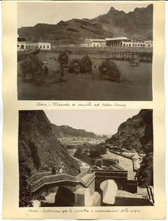
Ancient Views of Aden Photograph - Original Albumen Print - 1880s/90s
Located in Roma, IT
Ancient views of Aden is a set of three original vintage albumen prints on single cardboard: 34 x 26 cm.
Two Images 15 x 21, on the front and on the rear 28 x 22 cm which depicted ...
Category
Late 19th Century Modern Figurative Photography
Materials
Photographic Paper
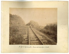
Ancient Landscapes near S. Josè Guatemala - Original Vintage Photo - 1880s
Located in Roma, IT
Ancient Landscapes near S. Josè Guatemalais a lot of two different original albumen prints made in the 1880s.
Prints in very good condition, applied on a single cardboard.
Caption ...
Category
1880s Landscape Photography
Materials
Photographic Paper, Paper
Ancient View ofValley of St. Nicholas - Original Lithograph - Mid-19th Century
Located in Roma, IT
Scene in the Valley of St. Nicholas is an original modern artwork realized in the half of the 19th Century.
Original B/W Lithograph on Ivory Paper.
Inscripted on the lower margin ...
Category
Mid-19th Century Figurative Prints
Materials
Paper, Lithograph
More Ways To Browse
Terre De Fer
John Speed Maps
Antique Map Of Turkish Empire
Antique Portuguese Scales
Canadian Atlas Furniture
Prussia Map
Afghanistan Map
Malabar Map
Antique Compass Made In France
Antique Maps Dublin
Antique Newfoundland Canada
John Speed Antique Maps
Malaysia Map
Sebastian Munster
Antique Map Chile
Antique Map Of Boston
Ipswich Antique Furniture
Maps Balkans