Items Similar to Cartographic Heritage: The 1901 Map of the Vizcaya Province in Spain


Want more images or videos?
Request additional images or videos from the seller
1 of 6
Cartographic Heritage: The 1901 Map of the Vizcaya Province in Spain
$306.99
$383.7420% Off
£228.37
£285.4620% Off
€256
€32020% Off
CA$420.37
CA$525.4720% Off
A$467.40
A$584.2520% Off
CHF 244.05
CHF 305.0620% Off
MX$5,689.38
MX$7,111.7320% Off
NOK 3,113.97
NOK 3,892.4620% Off
SEK 2,917.64
SEK 3,647.0520% Off
DKK 1,948.79
DKK 2,435.9820% Off
Shipping
Retrieving quote...The 1stDibs Promise:
Authenticity Guarantee,
Money-Back Guarantee,
24-Hour Cancellation
About the Item
This is a historical map of the province of Vizcaya (Biscay) in Spain, dated 1901. The title on the map is "VIZCAYA. 1901." It shows the topographical details of the region with contour lines and coloring to represent elevation changes. The map includes cities, towns, rivers, and railroads, with key locations such as Bilbao marked as the capital of the province. The coastline along the Cantabrian Sea is well defined. There are various symbols used to denote features such as railroads, telegraph stations, and roads. The map also includes a scale in kilometers, a legend explaining the symbols used (denoted as "Signos Convencionales"), and an inset detailing the provincial coat of arms. The surrounding areas of Santander, Burgos, Álava, and Guipúzcoa are also partially visible. The map is detailed and likely served for administrative or navigational purposes at the beginning of the 20th century.
The province of Vizcaya, known in Basque as Bizkaia, is rich in cultural, historical, and geographical significance. Here are some interesting facts about this area:
1. **Cultural Identity**: Vizcaya is one of the provinces that make up the Basque Country, an autonomous community in northern Spain. The Basque Country has its own language (Euskera), unique cultural traditions, and a distinct identity within Spain.
2. **Bilbao**: The capital city of Vizcaya is Bilbao, which underwent a significant transformation at the end of the 20th century. The city is famous for the Guggenheim Museum Bilbao, designed by architect Frank Gehry, which is a masterpiece of contemporary architecture and helped to revitalize the city.
3. **Industrial History**: Vizcaya was at the heart of the Industrial Revolution in Spain. The region was a major center for iron ore mining and steel production, which fueled its economic growth.
4. **Natural Landscapes**: The province features diverse landscapes, from the rugged coastline of the Bay of Biscay to the verdant mountains and valleys inland. The Urdaibai Biosphere Reserve is a UNESCO-recognized area of great ecological importance.
5. **Gastronomy**: Vizcaya is renowned for its culinary traditions, including pintxos (small snacks similar to tapas) and high-quality seafood. The region is also part of the Rioja Alavesa wine-producing area, known for its excellent wines.
6. **Language**: The Basque language, Euskera, is one of the oldest languages in Europe and is unrelated to any other known language. It is a central part of Vizcaya's cultural heritage.
7. **Suspension Bridge**: The Vizcaya Bridge, also known as the Puente Colgante, links the towns of Portugalete and Getxo over the Ibaizabal estuary. It's the world's oldest transporter bridge and was declared a World Heritage Site by UNESCO.
8. **Sporting Tradition**: The region has a strong affinity for sports, especially the traditional Basque games like pelota and rural sports, and football, with Athletic Bilbao being one of the most significant and historical football clubs in Spain.
9. **Historical Sites**: Vizcaya is home to numerous historical sites, from prehistoric settlements to medieval churches and modernist architecture, reflecting the region's rich history.
10. **Festivals**: The region is known for its vibrant festivals, such as the Semana Grande/Aste Nagusia of Bilbao, which is a big week-long festival with concerts, bullfights, and fireworks.
These facts reflect the multifaceted nature of Vizcaya, blending a rich cultural heritage with natural beauty and modern innovation.
- Dimensions:Height: 14.77 in (37.5 cm)Width: 20.08 in (51 cm)Depth: 0 in (0.02 mm)
- Materials and Techniques:
- Period:1900-1909
- Date of Manufacture:1901
- Condition:Good condition. Central vertical folding lines as issued. Aged paper with typically warm, yellowish-brown hue, especially around the edges and folding lines, adding to its patina. Check the images carefully.
- Seller Location:Langweer, NL
- Reference Number:Seller: BG-13642-451stDibs: LU3054338033832
About the Seller
5.0
Recognized Seller
These prestigious sellers are industry leaders and represent the highest echelon for item quality and design.
Platinum Seller
Premium sellers with a 4.7+ rating and 24-hour response times
Established in 2009
1stDibs seller since 2017
2,511 sales on 1stDibs
Typical response time: <1 hour
- ShippingRetrieving quote...Shipping from: Langweer, Netherlands
- Return Policy
Authenticity Guarantee
In the unlikely event there’s an issue with an item’s authenticity, contact us within 1 year for a full refund. DetailsMoney-Back Guarantee
If your item is not as described, is damaged in transit, or does not arrive, contact us within 7 days for a full refund. Details24-Hour Cancellation
You have a 24-hour grace period in which to reconsider your purchase, with no questions asked.Vetted Professional Sellers
Our world-class sellers must adhere to strict standards for service and quality, maintaining the integrity of our listings.Price-Match Guarantee
If you find that a seller listed the same item for a lower price elsewhere, we’ll match it.Trusted Global Delivery
Our best-in-class carrier network provides specialized shipping options worldwide, including custom delivery.More From This Seller
View AllNavarra in Cartographic Detail: A 1902 Map of the Crossroads of Northern Spain
Located in Langweer, NL
The original antique map for sale shows the Spanish province of Navarra as it was in 1902. Here's a brief description and a potential title for the map:
Description:
- The map detai...
Category
Antique Early 1900s Maps
Materials
Paper

$326 Sale Price
20% Off
Free Shipping
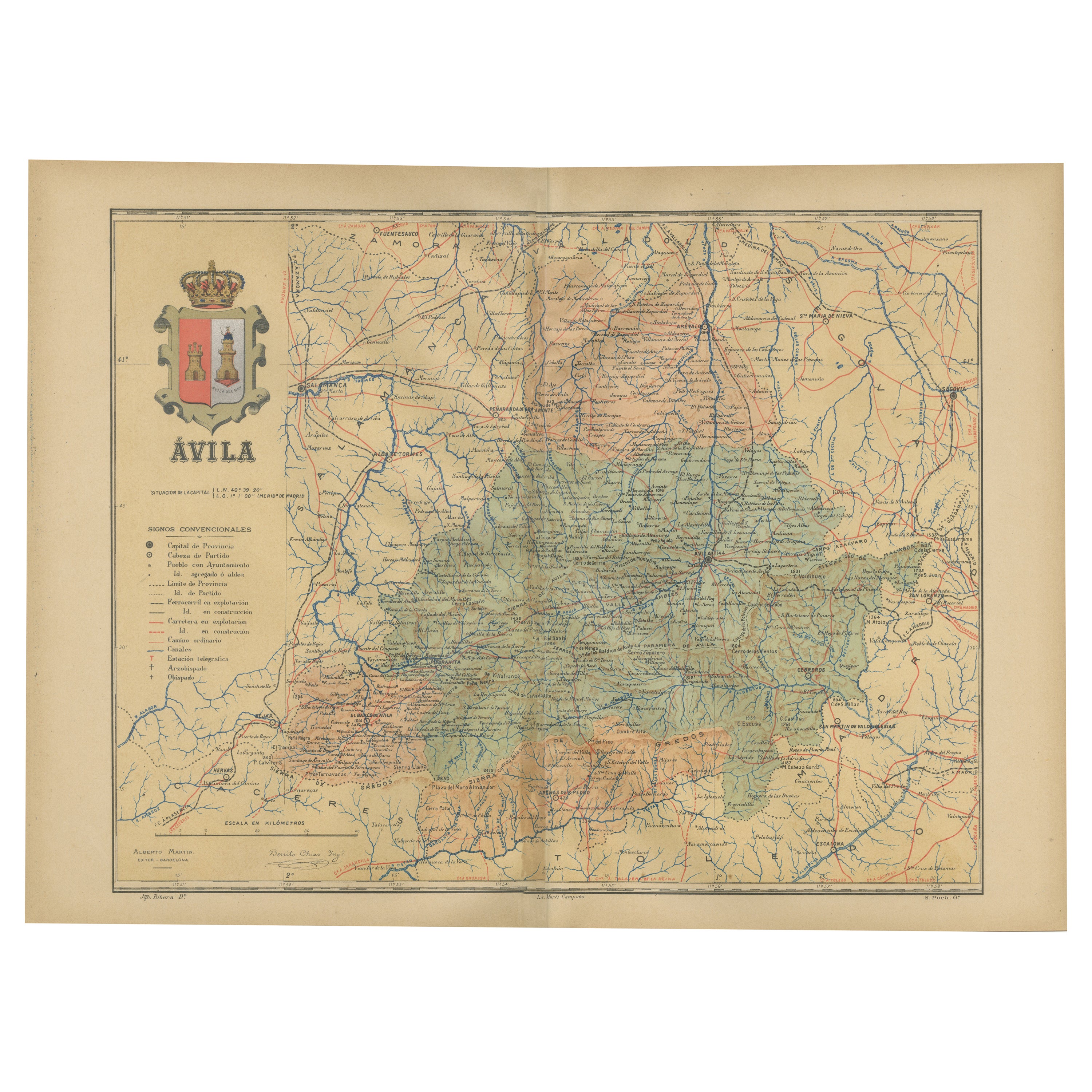
Ávila in a Historical Map of 1902: A Geographic and Administrative Overview
Located in Langweer, NL
The map is of the province of Ávila, one of the provinces of the autonomous community of Castile and León in Spain, and it is dated from 1902. The map illustrates several geographic ...
Category
Antique Early 1900s Maps
Materials
Paper

$278 Sale Price
20% Off
Free Shipping
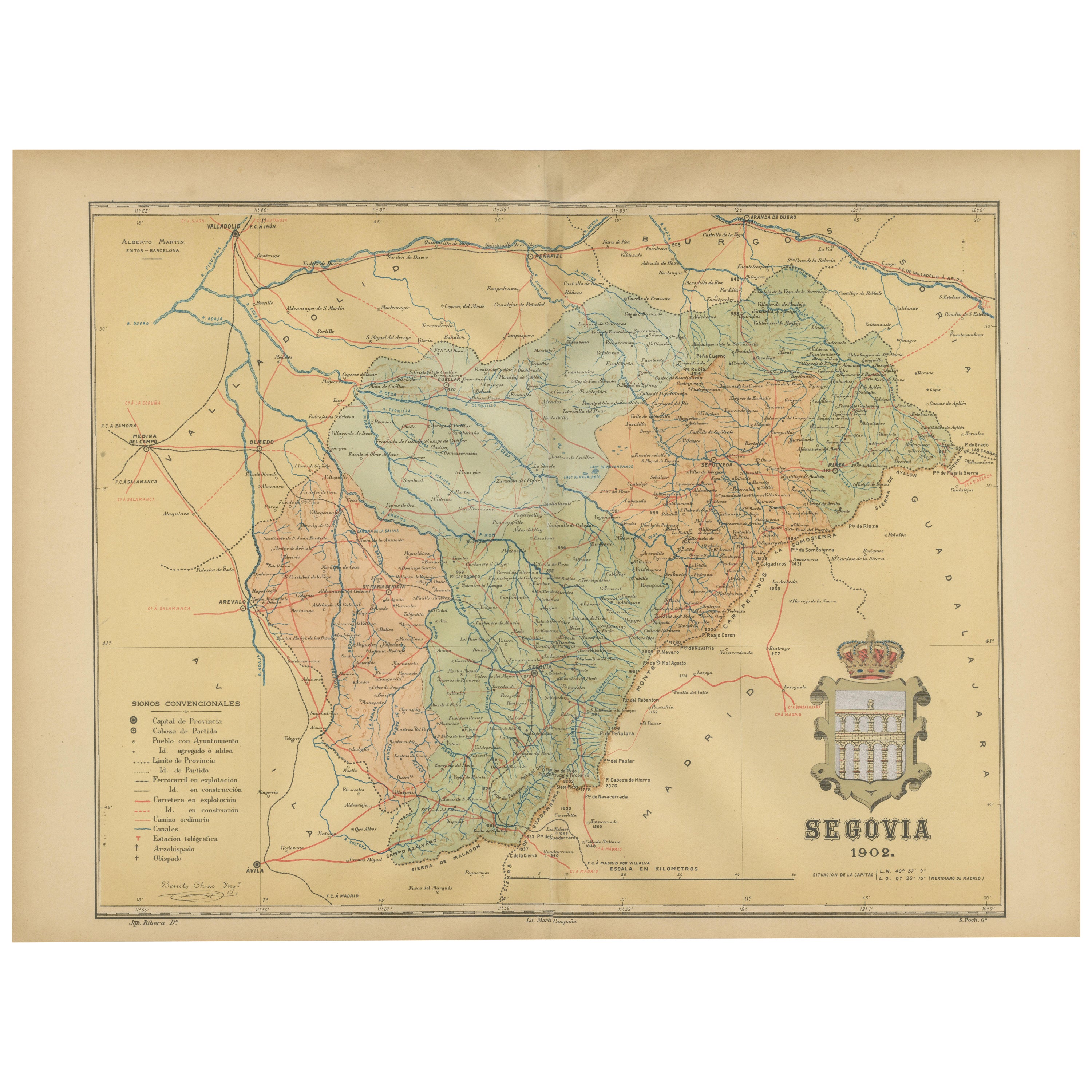
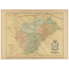
Topographical and Administrative Cartography of Segovia in Spain, 1902
Located in Langweer, NL
An original old map of the province of Segovia from the year 1902. Segovia is a historic area located in the central part of Spain, northwest of Madrid. Known for its rich history, a...
Category
Antique Early 1900s Maps
Materials
Paper
$278 Sale Price
20% Off
Free Shipping
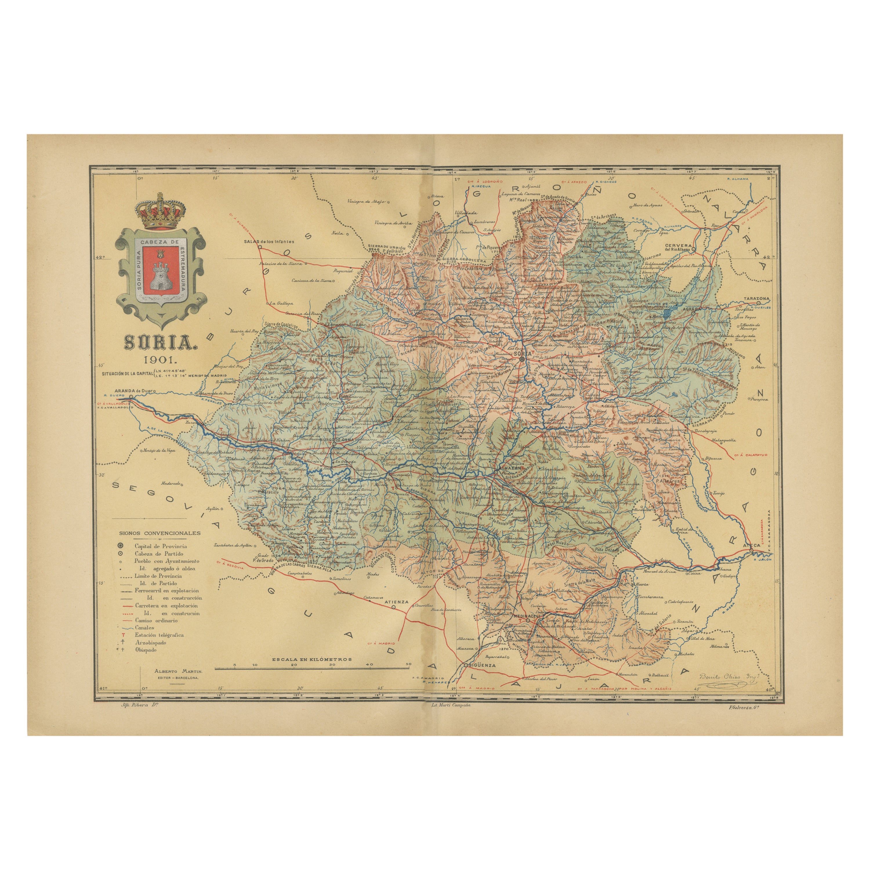
Map of Soria Province, 1901: Detailed Cartography of Northeastern Spain
Located in Langweer, NL
The map is a historical map of the province of Soria from 1901.
A decorative coat of arms enhances the aesthetic of the map, signifying the historical and cultural significance of ...
Category
Antique Early 1900s Maps
Materials
Paper

$316 Sale Price
20% Off
Free Shipping
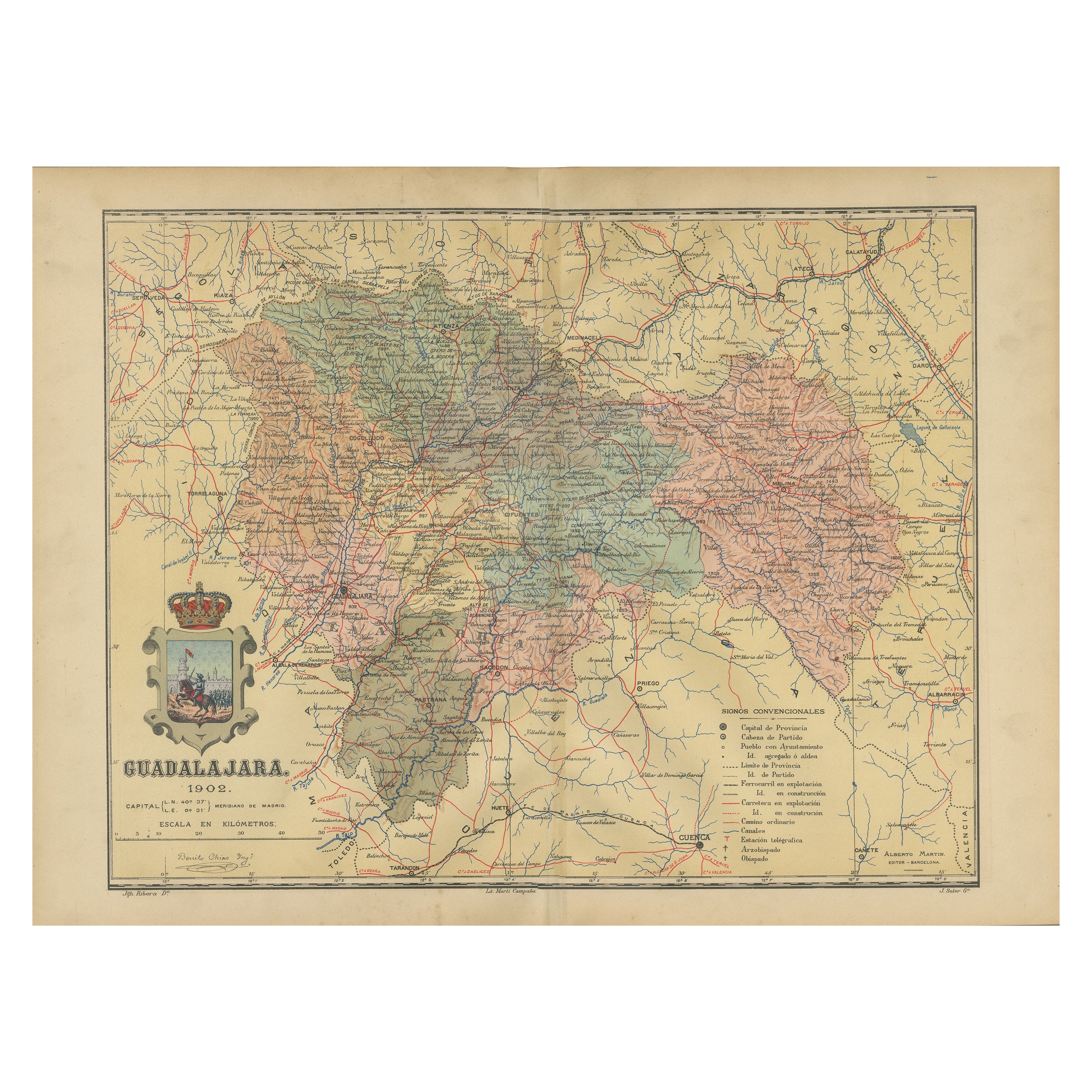
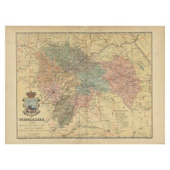
Guadalajara 1902: A Cartographic Image of Castilla-La Mancha's Northern Province
Located in Langweer, NL
The map illustrates the province of Guadalajara, part of the autonomous community of Castilla-La Mancha in Spain, as of 1902. The map includes various geographic and infrastructural ...
Category
Antique Early 1900s Maps
Materials
Paper
$278 Sale Price
20% Off
Free Shipping
Topographical and Infrastructure Map of the Province of Valencia, 1901
Located in Langweer, NL
A historical map of the province of Valencia, dated 1901. The map includes intricate details such as topographical features, with mountain ranges and river systems prominently marked...
Category
Antique Early 1900s Maps
Materials
Paper

$498 Sale Price
20% Off
Free Shipping
You May Also Like
Large Original Vintage Map of Spain, circa 1920
Located in St Annes, Lancashire
Great map of Spain
Original color.
Good condition
Published by Alexander Gross
Unframed.
Category
Vintage 1920s English Maps
Materials
Paper

South America, Eastern Part. Century Atlas antique vintage map
Located in Melbourne, Victoria
'The Century Atlas. South America. Eastern Part'
Original antique map, 1903.
Inset map 'Rio de Janeiro and Vicinity'.
Central fold as issued. Map name and number printed on the rev...
Category
Early 20th Century Victorian More Prints
Materials
Lithograph

Original Antique Map of Spain and Portugal, circa 1790
Located in St Annes, Lancashire
Super map of Spain and Portugal
Copper plate engraving by A. Bell
Published, circa 1790.
Unframed.
Category
Antique 1790s English Other Maps
Materials
Paper

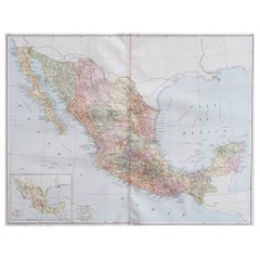
Large Original Vintage Map of Mexico, circa 1920
Located in St Annes, Lancashire
Great map of Mexico
Original color.
Good condition
Published by Alexander Gross
Unframed.
Category
Vintage 1920s English Edwardian Maps
Materials
Paper
South America, North-West Part. Century Atlas antique vintage map
Located in Melbourne, Victoria
'The Century Atlas. South America, North-West Part'
Original antique map, 1903.
Central fold as issued. Map name and number printed on the reverse corners.
Sheet 40cm by 29.5cm.
Category
Early 20th Century Victorian More Prints
Materials
Lithograph

1751 Map of Spain Castilla Robert De Vaugondy 1st Edition, Ric.a001
Located in Norton, MA
Large Spain Castilla Robert De Vaugondy
1751 1st Edition
-Colored- Ric.a001
Coming from a family of cartographers, a descendant of the famous Nicolas Sanson and ordinary geographer of the king, Gilles Robert de Vaugondy makes himself known by his maps of the French provinces.
He published an Essay on the History of Geography (1755) from which he excluded the physical geography "too systematic". After a Small Atlas (1748), he draws a universal Atlas (1758), a portable Atlas (1762).
His Atlas of the revolutions of the globe remains unpublished. His warnings and prefaces, his book reviews reveal a Cartesian mind and solid knowledge.
Very early, he associates with his works his son Didier who publishes, since 1742, the methodical tables of Nicolas Sanson, two Globes, one terrestrial, the other celestial (1752).
He is credited with a map of Poland...
Category
Antique 18th Century Unknown Maps
Materials
Paper

More Ways To Browse
Spanish Provincial
Sports Football
Antique Football
Antique Basque
Gehry Contour
Antique Oushak
Mid Century Danish Directors Chairs
Moller 70
Argentina Travel Poster
Century Furniture Faux Bamboo
Early American Chairs
Hans Muller
Vintage Wood Table With Glass Top
19th Century Square Table
Antonio Bonet
Galle Chairs
Large Chinese Rug
1940s Vintage French Art Deco